The St. Lucie County Map brings together two very different urban areas on Florida’s Atlantic side: the inlet city of Fort Pierce and the much broader municipal footprint of Port St. Lucie. To the east, the Indian River and Atlantic coast form a long water edge. Farther inland, I-95 and Florida’s Turnpike cross the county from north to south, while local roads tie the coastal communities to the western interior. This page uses the three maps actually included in the package—a county map, a city-connections map, and a terrain-and-water map—to explain those relationships without adding map types that are not present.
You can view each map in the article and download the matching files as a ZIP containing three high-resolution A3 JPG maps. The county map is best for roads, places, and boundaries; the city map simplifies the relative position of the incorporated municipalities; and the water map makes the Indian River, St. Lucie River system, Atlantic coast, and named creeks easier to follow.
Table of Contents
Two urban centers on one long coastal county
Fort Pierce sits in the east-central part of St. Lucie County close to the Indian River, while Port St. Lucie occupies a much larger area across the southern half of the county. North of Fort Pierce, the map labels St. Lucie Village and Lakewood Park. Between Fort Pierce and Port St. Lucie, White City and River Park help show how the developed part of the county continues southward rather than ending at either city boundary. The county outline also makes the Atlantic-facing eastern edge and the angled southern boundary toward Martin County easy to recognize.
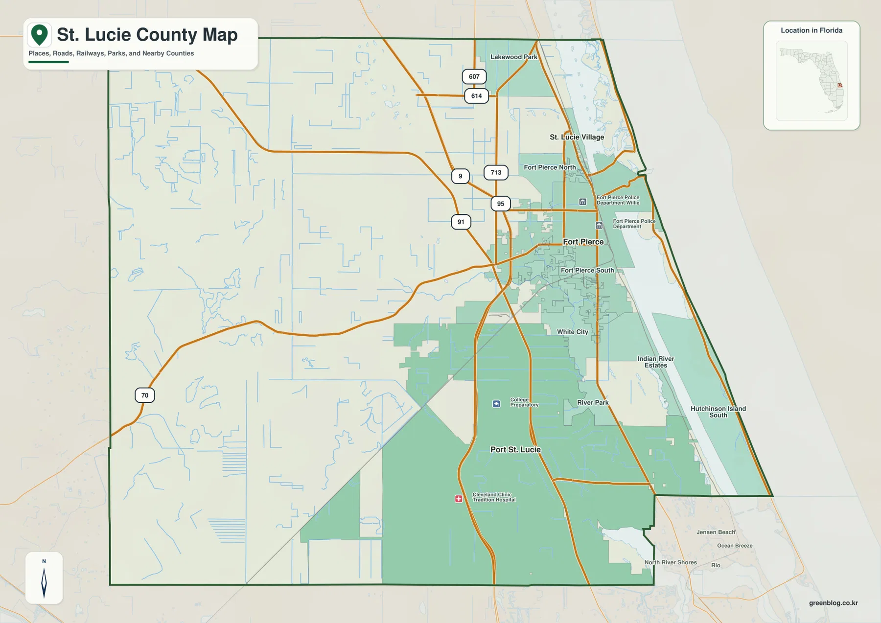
The road pattern is a useful way to orient the map. US 1 follows the more urbanized eastern mainland and links the Fort Pierce and Port St. Lucie areas. I-95 and Florida’s Turnpike run farther inland, creating two strong north-south reference lines. The map also marks SR 70, SR 68, and local route numbers such as 607, 614, and 713, which helps when tracing movement from the coast toward the western county or north toward Lakewood Park. The result is a clear contrast between the denser eastern corridor and the more open interior crossed by canals, creeks, and fewer major place labels.
Reading the city positions from Port St. Lucie
The city-connections map strips away much of the smaller detail and uses Port St. Lucie as the hub. That makes the municipal pattern immediately clear: Port St. Lucie is the southern anchor, Fort Pierce lies to the northeast, and St. Lucie Village sits farther north along the lagoon side of the county. This view is especially helpful when the full county map feels busy, because it focuses attention on the three incorporated municipalities rather than every road and community name.
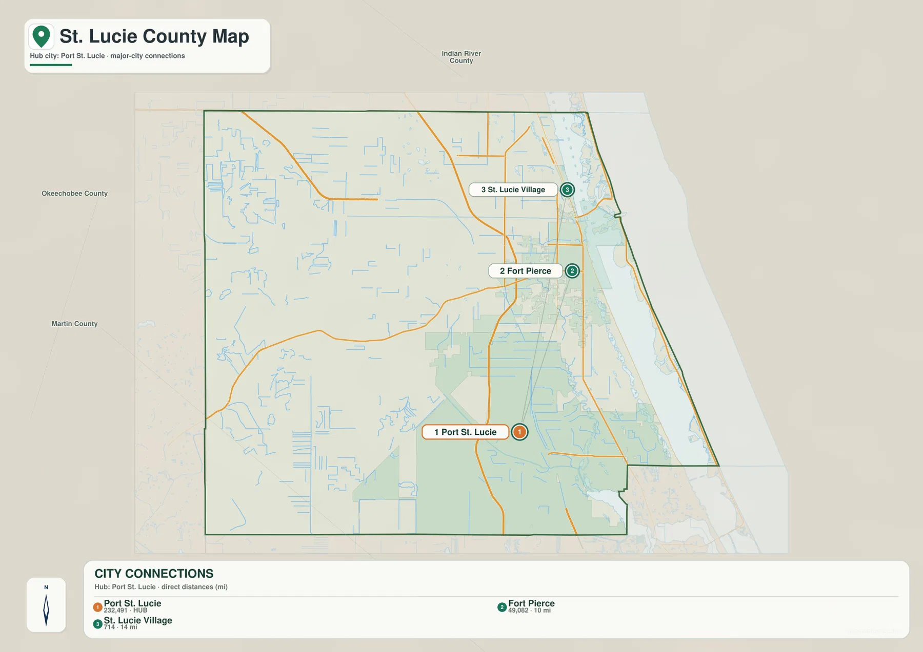
The distance labels need one important qualification. The map identifies Fort Pierce as about 10 miles from Port St. Lucie and St. Lucie Village as about 14 miles away, but these are direct distances, not driving distances. A road trip can be longer because the actual route must follow the available street network and crossings. The city map is therefore best used to answer a simple orientation question—where one municipality lies in relation to another—rather than as a substitute for turn-by-turn travel mileage.
The size difference between the municipalities also explains why the markers do not tell the whole story. Port St. Lucie spreads across a broad southern area and extends west of I-95, while Fort Pierce is more compact and concentrated near the Indian River and inlet side of the county. St. Lucie Village is much smaller still. On the full map, those differences are visible in the municipal footprints; on the city-connections map, the numbered markers keep the comparison simple.
From the Atlantic and Indian River to the North Fork
Water is a defining part of the county’s eastern side, and the terrain-and-water map makes that easier to see than the general road map. The Atlantic Ocean fills the far eastern edge. Immediately inland, the Indian River runs along the coast, while the St. Lucie River and North Fork St. Lucie River extend through the mainland side of the county. The map also labels several smaller creeks, allowing the reader to follow water features from the coast into the interior instead of treating the shoreline as a single blue boundary.
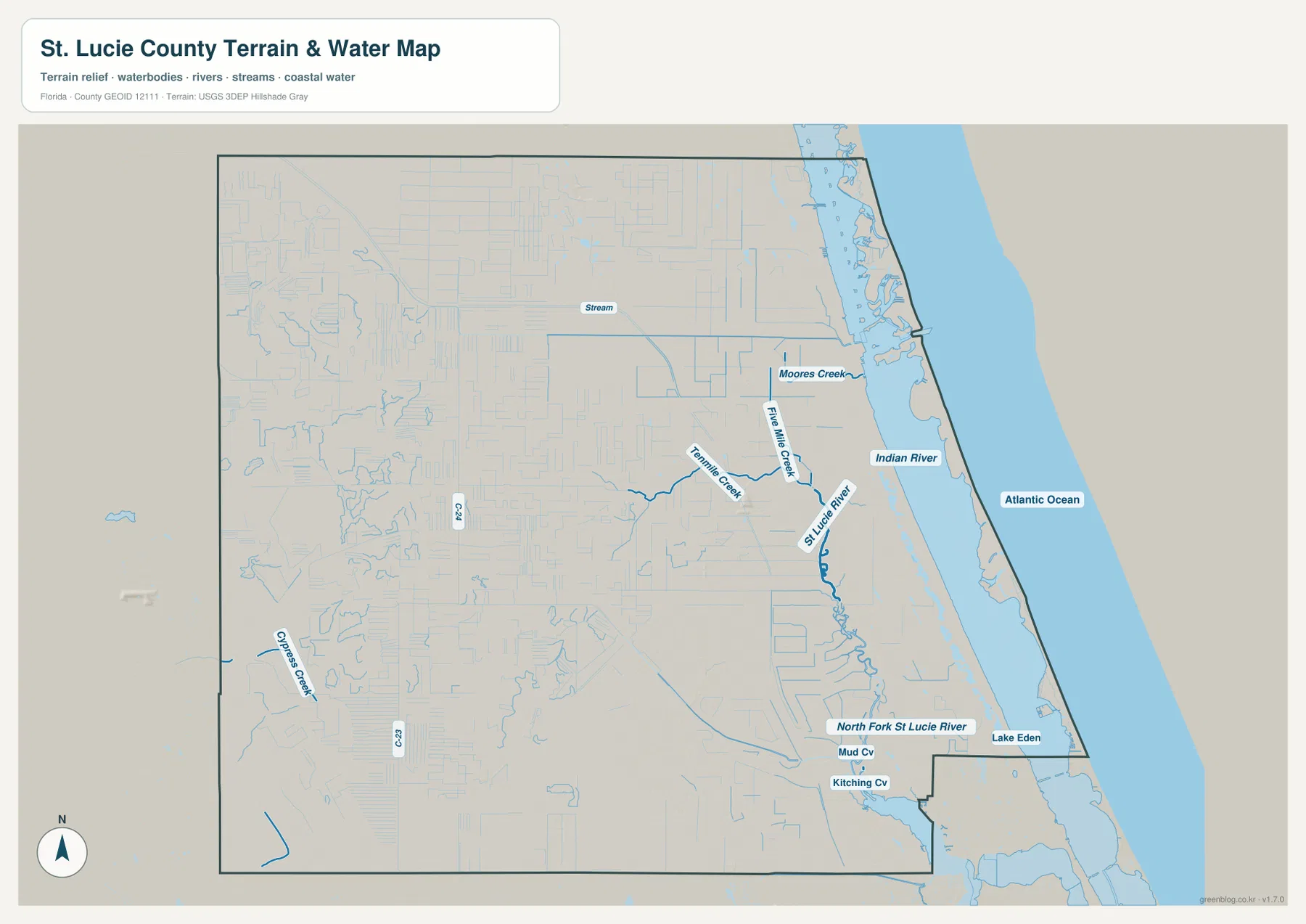
Tenmile Creek and Five Mile Creek are both labeled in the central part of the county near the St. Lucie River system. Moores Creek appears farther north, and Cypress Creek is marked in the western interior. Near the southern boundary, the map also names Mud Cv, Kitching Cv, and Lake Eden. These smaller labels are useful because they show that the county’s water geography is not limited to the obvious coastal strip. Streams and canals extend well inland, while the larger river branches shape the eastern side of Port St. Lucie.
The water map works best as a companion to the county map. It gives the rivers and coastal waters stronger visual emphasis, but it does not carry the same amount of road and community detail. If you need to understand how a creek sits relative to Port St. Lucie or Fort Pierce, first locate the city or road on the county map, then switch to the water map to follow the nearby river or stream. That two-step approach makes the geography much easier to read than trying to force every detail into one image.
Coastal places, inland highways, and the county’s east-west contrast
Place names become more concentrated as the map approaches the Indian River side. Fort Pierce, St. Lucie Village, Fort Pierce North, Fort Pierce South, White City, Indian River Estates, and Hutchinson Island South all help define the eastern half. South of the county line, labels such as Jensen Beach and Rio appear in Martin County, which provides useful context for the county’s southeastern edge. The western side, by comparison, has fewer major city labels and a more open pattern crossed by long roads and numerous narrow drainage lines.
I-95 and Florida’s Turnpike are the clearest inland reference corridors. Port St. Lucie’s large municipal area reaches across and around these highways, including western planned areas described in the source material such as Tradition and St. Lucie West. Fort Pierce remains closer to the Indian River, so the two main cities meet the county’s transportation and water geography in different ways. That difference is useful when explaining the county: Fort Pierce is the compact inlet-side county seat, while Port St. Lucie forms the broad southern urban area stretching from the river side into the interior.
St. Lucie County borders Indian River County to the north, Okeechobee County to the west, and Martin County to the south, with the Atlantic on the east. The county map shows those relationships directly and is useful when a route continues beyond the county line. For example, Lakewood Park sits near the northern side, while the southern Port St. Lucie area approaches the Martin County boundary. Using the boundary together with the road network prevents nearby places in adjacent counties from being mistaken for St. Lucie County locations.
Choosing the map that matches the task
For general orientation, the county map should usually come first. It combines the places, roads, county outline, and surrounding context needed to locate Fort Pierce, Port St. Lucie, Lakewood Park, White City, River Park, and other mapped communities. It is the most useful option for trip planning at a broad scale, county introductions, or any situation where the relationship between roads and place names matters.
The city-connections map is better when the explanation is specifically about the three municipalities. Because it uses Port St. Lucie as the hub and labels the direct distance to Fort Pierce and St. Lucie Village, it communicates the north-south order quickly without the visual weight of every road. The water map serves a different purpose: it is the better choice for showing the Indian River, Atlantic coast, St. Lucie River branches, and named creeks.
The downloadable ZIP keeps all three views together, which makes them easy to use as a set. A printed county map can establish the overall location, the city map can simplify a municipal comparison, and the water map can add river and coastal detail. Since all three cover the same county, readers can move between them without having to learn a new extent or region each time.
Frequently Asked Questions
Why does Port St. Lucie look much larger than Fort Pierce on the county map?
The two cities have very different municipal footprints. Port St. Lucie covers a broad part of southern St. Lucie County and extends west of I-95, while Fort Pierce is more compact and concentrated near the Indian River and inlet side of the county. At the same map scale, Port St. Lucie therefore occupies far more visible area.
Are the 10-mile and 14-mile labels on the city map driving distances?
No. The city-connections map identifies direct distances from the Port St. Lucie hub: roughly 10 miles to Fort Pierce and 14 miles to St. Lucie Village. Actual road mileage depends on the starting point, destination, and route used, so the labels should be treated as straight-line orientation rather than navigation distances.
How can I tell the Indian River from the Atlantic Ocean on the water map?
The Atlantic Ocean is the broad water area on the far eastern side of the map. The Indian River lies immediately to its west, between the mainland and the narrow coastal land. Reading the two together helps explain why Fort Pierce and other eastern communities sit beside an inland lagoon-like waterway even though the open Atlantic is only a short distance farther east.
Map File Information
The ZIP contains high-resolution A3 JPG versions of the St. Lucie County county map, city-connections map, and water map.
- Included Files: County map JPG, city-connections map JPG, water map JPG
Related Maps
- Arcadia Roads and Peace River | DeSoto County Florida Map
- Baker County Florida Map
- Between the Aucilla and Withlacoochee: Madison County Florida Map
Sources
These official and local sources provide county facts, water-recreation context, environmental information, and highway references used alongside the supplied maps.
- U.S. Census Bureau QuickFacts — St. Lucie County, Florida
- St. Lucie County Government — Facts & Stats
- Visit St. Lucie — Water Recreation
- St. Lucie County Greenways and Paddling Trails
- Florida Department of Transportation — I-95 Exit Numbers
Green Map creates custom-edited map images using open geographic data sources such as geoBoundaries, Natural Earth, OpenStreetMap, and government open data.
These maps are edited visual materials, not raw data files, and are provided for education, documents, presentations, and graphic reference.