The St. Johns County Map covers a long stretch of northeast Florida where the Atlantic shore, the St. Augustine area, the fast-growing north, the St. Johns River side, and the inland southwest do not look alike on the map. St. Augustine sits near the east-central coast, while Vilano Beach, Nocatee, Palm Valley, and Sawgrass extend northward. Fruit Cove lies far to the northwest near the St. Johns River, World Golf Village occupies a more central position, and Hastings is well inland in the southwest.
This page includes a general county map for places, roads, and boundaries; a city map that isolates the county’s two incorporated cities; and a water map that emphasizes rivers, creeks, lakes, and the Atlantic Ocean. The matching three high-resolution A3 JPG files are available together in one ZIP download below. If you are new to the county, start with St. Augustine and the St. Johns River as reference points, then compare the coast, the northern communities, and the inland southwest.
Table of Contents
A County Stretched Between the Atlantic and the St. Johns River
St. Johns County has a distinctive shape. It runs a long distance north to south along the Atlantic side of Florida, yet its western side reaches toward the St. Johns River. The material in this package identifies Duval County on the north, Clay County on the northwest and west, Putnam County on the southwest, and Flagler County on the south. The Atlantic Ocean forms the eastern edge, while part of the western boundary follows the St. Johns River. That geometry explains why two places in the same county can belong to very different landscapes.
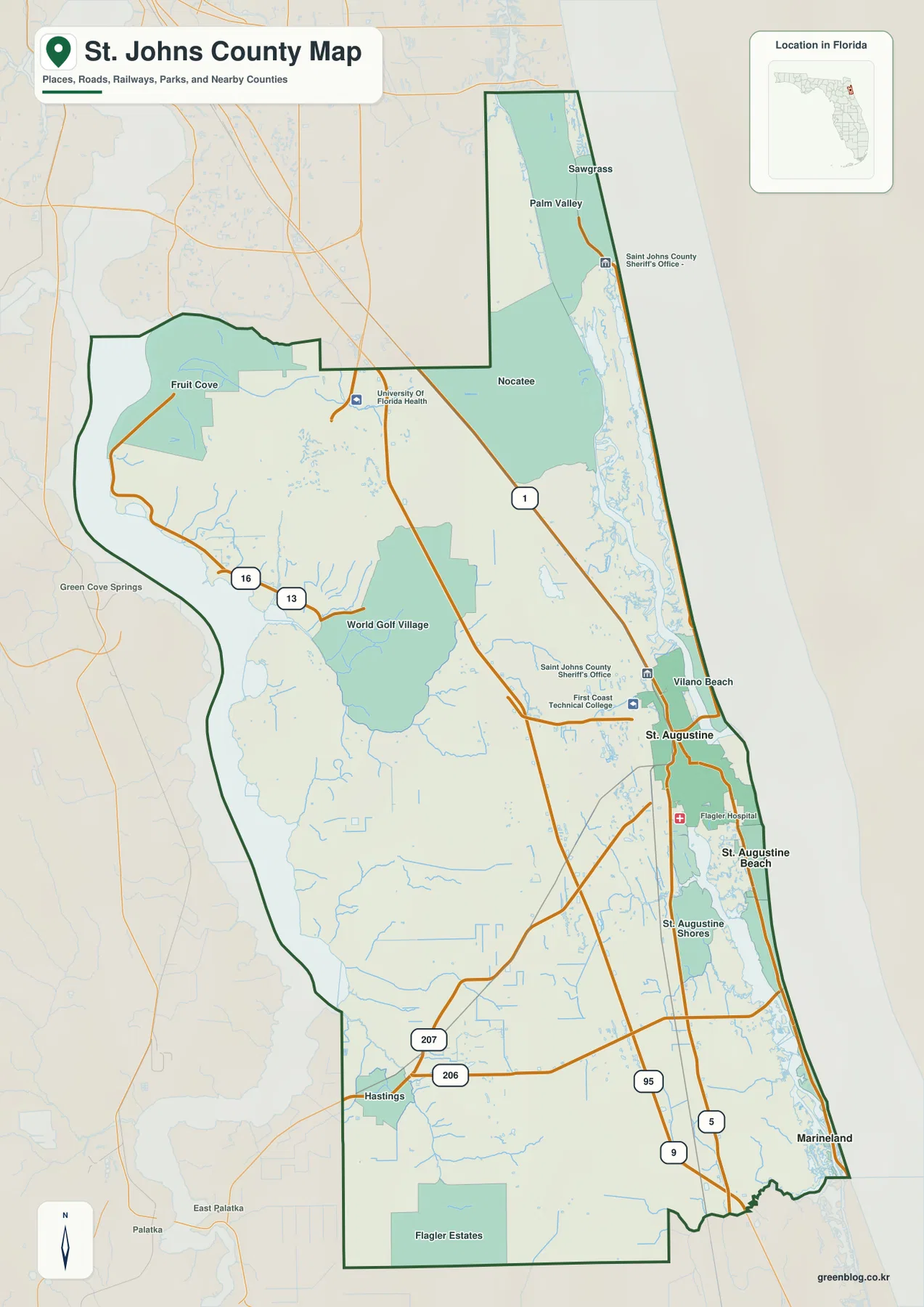
The general map makes that spread easy to see. St. Augustine is the main east-central reference point. Vilano Beach lies just north of it on the coast, while Nocatee, Palm Valley, and Sawgrass are much farther north. Fruit Cove appears in the northwest near the river side of the county. World Golf Village is closer to the middle, Hastings is in the southwest, Flagler Estates is in the southern interior, and Marineland appears near the southeastern coastal end. A map focused only on St. Augustine would miss much of this geographic range.
Roads provide the clearest way to connect these separated areas. The map shows U.S. 1 and I-95 running north and south through the county, with SR 16, SR 13, SR 207, and SR 206 serving different east-west or inland directions. SR 16 links St. Augustine with World Golf Village and the western side, while SR 207 heads southwest from the St. Augustine area toward Hastings. Those two routes are especially useful to distinguish because both lead inland but reach different parts of the county.
St. Augustine and St. Augustine Beach Are Two Different Cities
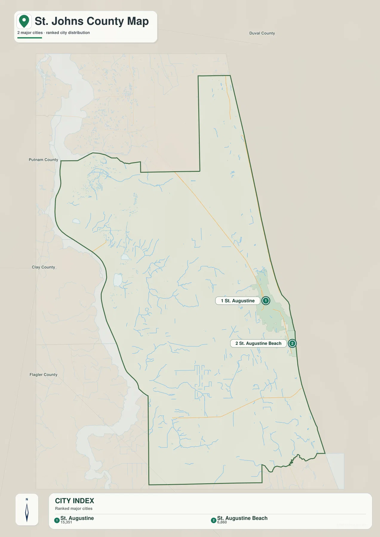
St. Augustine is the county seat, but it is not simply the same place as the beach community directly to its southeast. The current county material identifies St. Augustine and St. Augustine Beach as the county’s two incorporated cities. St. Augustine occupies the mainland side near the local river and estuarine system, while St. Augustine Beach sits farther south and east on the coastal side. The general map keeps the labels separate, and the city map makes the distinction even clearer.
The city map in this package deliberately shows only those two incorporated cities. Its ranked labels display St. Augustine with a value of 15,315 and St. Augustine Beach with 6,860. Those figures are part of the supplied city-map graphic and are useful here mainly because they accompany a very simple location comparison: St. Augustine is the northern and more inland of the two points, while St. Augustine Beach lies to the southeast near the Atlantic side.
Many well-known names on a St. Johns County map are not incorporated cities. The county information included with this package lists places such as Ponte Vedra, Nocatee, Fruit Cove, Vilano Beach, Crescent Beach, Switzerland, Tocoi, Picolata, Orangedale, and Hastings among unincorporated communities. That distinction matters when reading the general map: a prominent place label tells you where a community is, but it does not by itself indicate a separate municipal government or city boundary.
Nocatee, Fruit Cove, and World Golf Village Occupy Different Parts of the North
Northern St. Johns County can look like one continuous growth area at first glance, but the map separates several distinct clusters. Nocatee and Palm Valley are on the eastern side between the coast and the U.S. 1 corridor. Fruit Cove is much farther west, near the St. Johns River side. World Golf Village lies south of both, closer to the I-95 and SR 16 area. These communities share a northern location relative to St. Augustine, yet they do not use the same roads or face the same waterways.
The source material describes CR 210 as an important east-west route across the north, connecting the Fruit Cove area with I-95, U.S. 1, and access toward the eastern side. SR 13 is useful for understanding the western river-side communities, including the Switzerland area. By contrast, Nocatee and Palm Valley are easier to place by looking at their position between U.S. 1 and the coast. Reading the north as several corridors rather than one neighborhood makes the county map much clearer.
The general map also includes selected public and institutional landmarks. These labels can help orient the viewer, particularly in the north and around St. Augustine, but they should not be treated as a complete inventory of county facilities. For this page, their value is mainly as reference points that help distinguish one road or community from another.
Rivers, Creeks, and Estuarine Waterways Shape the County
The water map shows why a simple road map cannot explain the whole county. The St Johns River occupies the western side, while the Atlantic Ocean forms the long eastern edge. Between them is a network of named waterways. Cunningham Creek and Durbin Creek appear in the north. Farther south and west are Mill Creek, Turnbull Creek, Sixmile Creek, Mc Cullough Creek, and Moccasin Branch. Near St. Augustine, Hospital Creek and Maria Sanchez Lake are labeled, and the Matanzas River runs along the eastern side south of the city area.
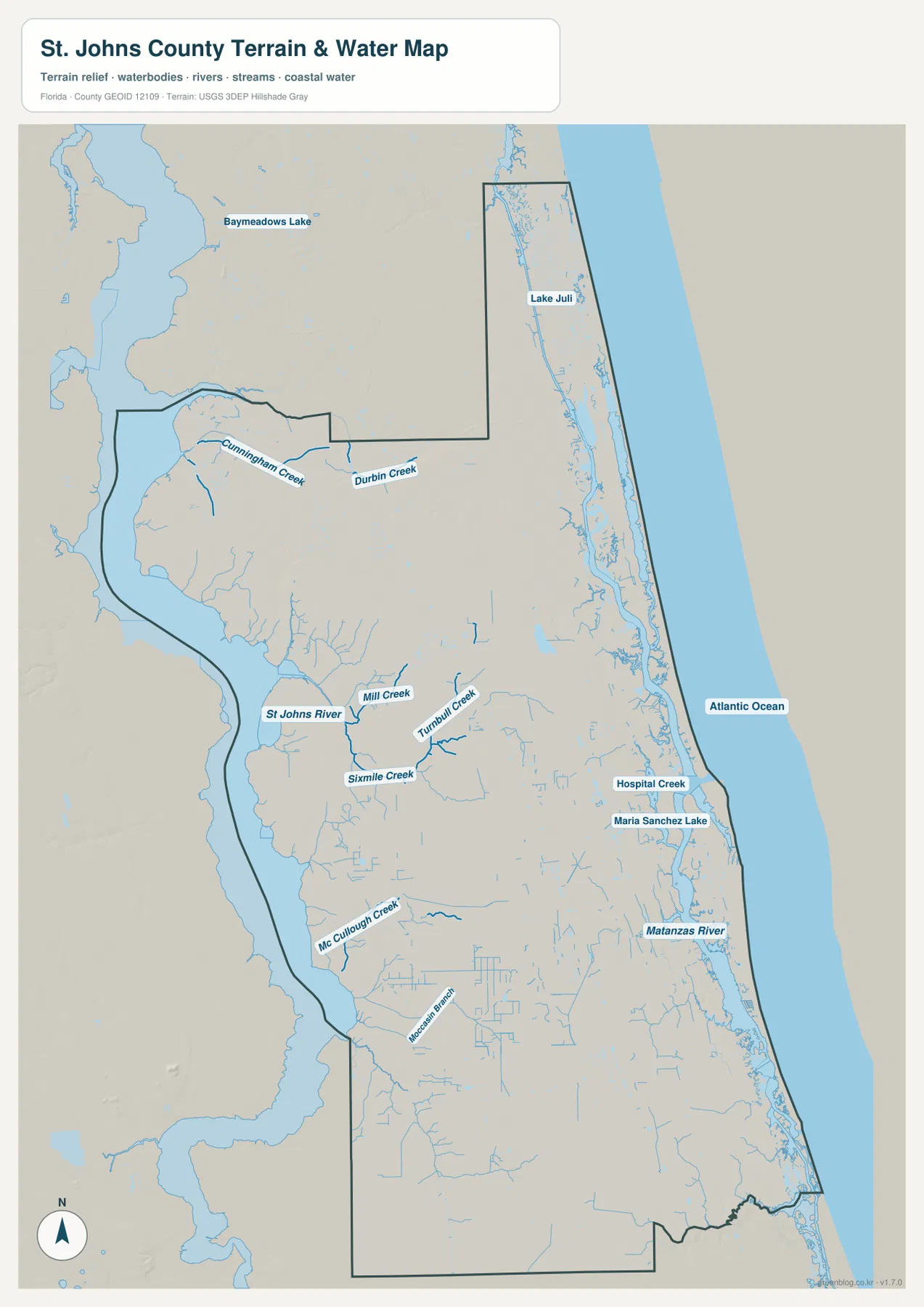
The existing county text also explains that the Tolomato River to the north and the Matanzas River to the south are named reaches of the Intracoastal Waterway. Marshes, creeks, islands, and shallow estuarine areas lie between much of the mainland and the ocean. The Guana Tolomato Matanzas National Estuarine Research Reserve protects part of this coastal system. For a map reader, the important point is that the eastern edge is not one uninterrupted beach line with roads running straight across it.
Those waterways directly affect how routes work. Two points may look close across the map, yet a driver must use available bridges and causeways rather than travel in a straight line across marsh or open water. That is especially relevant around St. Augustine, the barrier-island side, and the northern coast. This water map is intended for geographic orientation; it is not a flood-zone map, a navigation chart, a parcel-boundary map, or a source for water-quality decisions.
Hastings Shows the County’s Inland Southwest
Hastings is one of the best place names for understanding how different the southwest is from the St. Augustine coast. On the general map it lies inland near SR 207 and SR 206, well away from the Atlantic side. The material in this package describes the Hastings-Elkton area as part of an inland agricultural district known for potato and vegetable production. That land-use setting contrasts with the coastal communities and the more suburban northern part of the county.
Hastings also has an important administrative detail. According to the county information supplied in the package, the town government dissolved in 2018 and Hastings is now part of unincorporated St. Johns County. Older maps can therefore show a town boundary that no longer represents the current municipal structure. When comparing historic and current maps, the date of the source matters.
Flagler Estates and Marineland provide two additional southern reference points. Flagler Estates appears in the southern interior, while Marineland is on the southeastern coast. They are both south of St. Augustine but lie in very different directions. Seeing both on the full county map makes the long north-south extent of St. Johns County easier to appreciate.
Which St. Johns County Map Should You Use?
For a first look, use the general county map and find St. Augustine. Then compare Nocatee and Palm Valley to the north, Fruit Cove to the northwest, World Golf Village inland, and Hastings to the southwest. If roads matter, start with I-95 and U.S. 1, then separate SR 16 from SR 207 before tracing a route west. The same map is also the best choice for locating Vilano Beach, Flagler Estates, Marineland, and the county boundary.
Use the city map when you only need the relative positions of the two incorporated cities. It removes most other labels and leaves St. Augustine and St. Augustine Beach as the main points. Use the water map when the St. Johns River, Matanzas River, Durbin Creek, Turnbull Creek, or the Atlantic shoreline is more important than the road network. Looking back and forth between the county and water maps is especially helpful when a route seems indirect because water lies between two places.
The A3 JPG files in the ZIP below are intended for printing and document use. Choose the county map for a broad mix of roads and place names, the city map for a clean comparison of the two incorporated cities, and the water map for rivers, creeks, and coastal water. All three cover the same county but emphasize different information, so you can use only the file that matches your purpose.
Frequently Asked Questions
Why does the city map show only two incorporated cities?
The county information included with this package identifies St. Augustine and St. Augustine Beach as the two incorporated cities. Names such as Nocatee, Ponte Vedra Beach, Vilano Beach, Crescent Beach, Fruit Cove, and Hastings refer to unincorporated communities. They may appear on the general map because they are useful geographic labels, but they are not shown as equivalent municipalities on the city map.
Is Hastings still an incorporated town?
No. The county material in this package states that Hastings dissolved its town government in 2018 and is now part of unincorporated St. Johns County. Older maps may still show the former municipal boundary, so the source date should be checked when comparing administrative maps.
Why can two coastal places look close on the map but require a longer road trip?
The eastern side of St. Johns County includes the Tolomato and Matanzas waterways, marshes, creeks, and barrier-island terrain between the mainland and the Atlantic. Roads must use available bridges and causeways, so a straight-line map distance does not always resemble the actual driving route. The water map is useful for seeing why those detours occur.
Map File Information
Download the St. Johns County county map, city map, and water map as high-resolution A3 JPG files.
- Included Versions: county map, city map, water map
- Included Files: 3 high-resolution A3 JPG images
Related Maps
- Arcadia Roads and Peace River | DeSoto County Florida Map
- Baker County Florida Map
- Between the Aucilla and Withlacoochee: Madison County Florida Map
Sources
For county organization, incorporated cities, and unincorporated communities, see St. Johns County Government and the U.S. Census Bureau QuickFacts for St. Johns County. The county’s information about Hastings after the 2018 dissolution is available from St. Johns County’s Hastings information page. Coastal and estuarine context can be checked through the Guana Tolomato Matanzas National Estuarine Research Reserve, while official state road context is available from the Florida Department of Transportation map resources.
Green Map creates custom-edited map images using open geographic data sources such as geoBoundaries, Natural Earth, OpenStreetMap, and government open data.
These maps are edited visual materials, not raw data files, and are provided for education, documents, presentations, and graphic reference.