You can download four high-resolution A3 JPG map files directly from this Lawrence County Alabama Map page. The downloadable ZIP includes a general county map, a ranked city map, a water map, and an elevation map, while the WebP previews let you review each version before choosing the file you need. Moulton, Wheeler Lake, the northern road corridor, and the wooded southern uplands give the county a clear geographic contrast that is easy to follow across the four maps.
The county is easiest to understand as a set of connected but visibly different areas. Moulton sits near the center-south and provides the strongest administrative and road reference point. Courtland, North Courtland, Town Creek, and Hillsboro cluster much farther north, closer to the Wheeler Lake corridor. The water map shows that the interior is crossed by a dense network of creeks rather than one or two isolated streams, while the elevation map shows a clear rise from the northern reservoir plain toward higher ridges and valleys in the southern part of the county.
Table of Contents
Moulton, Main Roads, and the County Boundary
Lawrence County lies in northwestern Alabama. The Tennessee River and Wheeler Lake shape much of the northern edge, with Lauderdale and Limestone counties on the opposite side of the river-reservoir corridor. Colbert and Franklin counties are to the west, Morgan and Cullman are to the east, and Winston County borders the south. The county outline is therefore irregular in the north, where water creates coves and bends, while the southern edge appears much straighter on the general map.
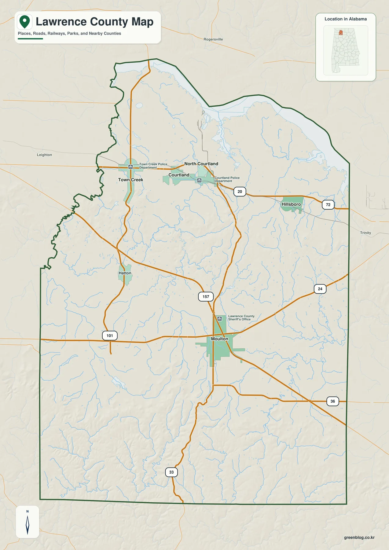
Moulton is the county seat and the most practical place to begin reading the map. It is located a little south of the county’s midpoint, where Alabama 24 crosses the broader north-south road system and Alabama 33 continues toward the forested southern county. Alabama 157 also provides an important connection north of Moulton. The Lawrence County Sheriff’s Office is labeled in town, reinforcing Moulton’s role as the administrative center rather than simply another small settlement on the road network.
The northern communities form a different pattern. Courtland and North Courtland sit close together, with Town Creek farther west and Hillsboro farther east. The main map shows an east-west highway corridor through this part of the county, including route shields for 20 and 72 near the Courtland-Hillsboro side. These communities are much closer to Wheeler Lake than Moulton is, and their road pattern is more strongly oriented east and west across the northern plain.
Hatton provides a useful reference between Moulton and the northwestern part of the county. Alabama 101 and Alabama 157 help connect rural western and central areas, while Alabama 36 appears east of Moulton and Alabama 33 continues south. No Interstate highway runs through the county, so U.S. and Alabama routes remain especially important for understanding regional movement. The general map is helpful here because it keeps the roads, streams, county line, and nearby places together instead of isolating one type of information.
| State | Alabama |
|---|---|
| County | Lawrence County |
| County seat | Moulton |
| 2025 population estimate | 33,843 |
| 2020 census population | 33,073 |
| Land area | 690.68 square miles |
| Roads visible on the map | AL 20, AL 24, AL 33, AL 36, AL 101, AL 157, US 72 corridor, and local roads |
| Major mapped waters | Wheeler Lake, Wilson Lake, Big Nance Creek, Mallard Creek, Town Creek, and others |
| Elevation map range | About 154–333 m; mean about 208 m |
QuickFacts gives a July 1, 2025 population estimate of 33,843, while the 2020 census counted 33,073 residents. Lawrence County also covers 690.68 square miles of land. Those figures help explain the map: this is a large county with a relatively small set of incorporated population centers, not a continuous urban landscape. Roads and place labels are concentrated around Moulton and the northern towns, while the southern part becomes increasingly dominated by forest, valleys, and smaller waterways.
Five Ranked Cities and the Northern Settlement Pattern
The city map simplifies the county to five ranked places: Moulton, Town Creek, Courtland, Hillsboro, and North Courtland. Removing much of the road and background detail makes one geographic fact especially clear. Moulton stands by itself in the central-southern part of the county, while the other four cities are grouped across the northern half near the Wheeler Lake side. The city view does not replace the general map—places such as Hatton and surrounding communities still matter—but it is much easier to use when the main question is how the principal named cities relate to one another.
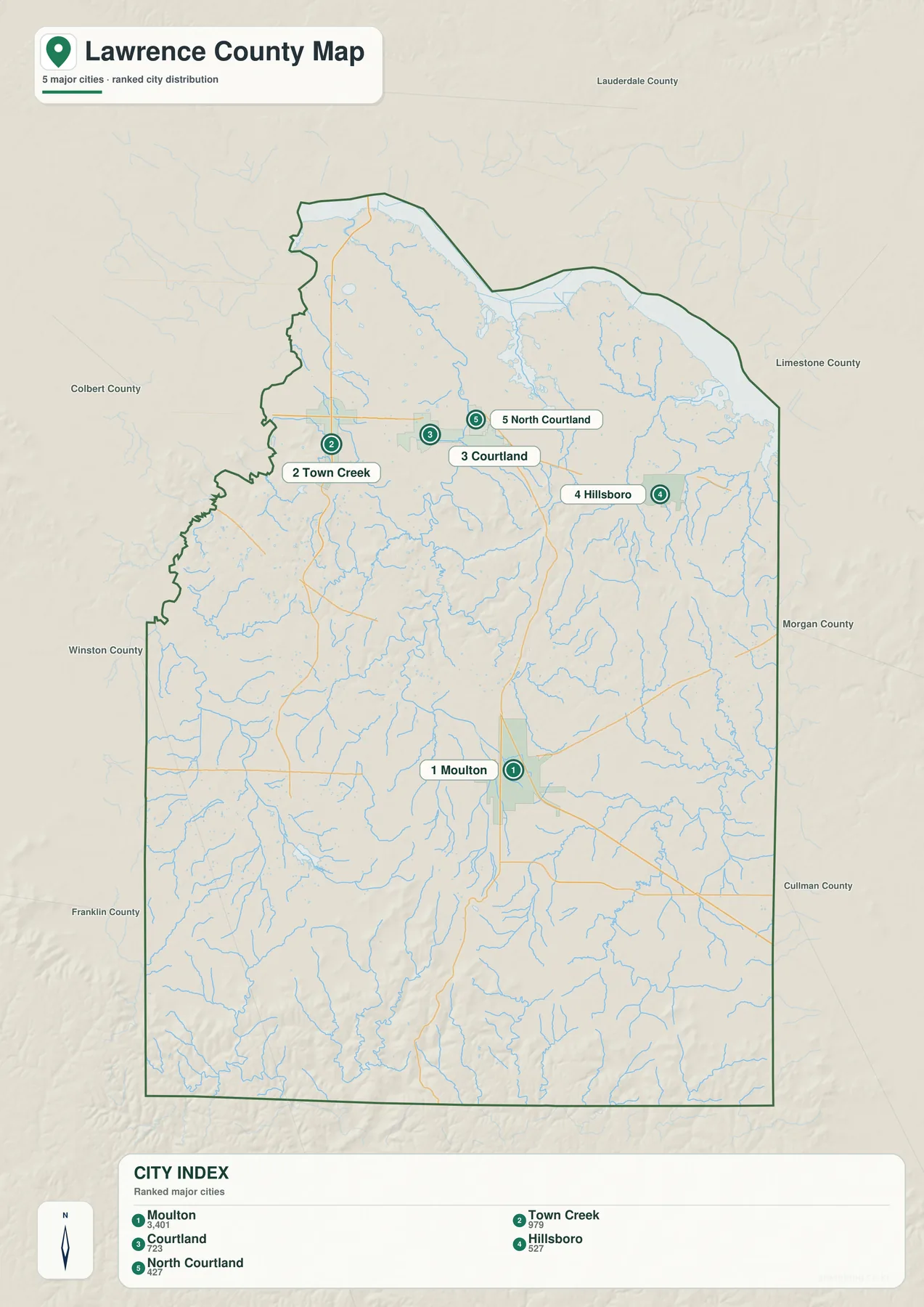
The city index on the map lists Moulton at 3,401 residents, Town Creek at 979, Courtland at 723, Hillsboro at 527, and North Courtland at 427. Those values are useful as a map reference because they show why Moulton is visually separated as the county’s largest municipal center. Even so, the numbers should not be read as the county’s total settlement pattern. Much of Lawrence County’s population lives outside these five incorporated places in rural communities and unincorporated areas.
Courtland and North Courtland are nearly adjacent, and the map places them within the same northern travel area. Courtland sits close to the east-west highway corridor that continues toward Hillsboro and Decatur. Town Creek is farther west, near routes leading through the northwestern agricultural area. The arrangement is not a straight row of towns along the shoreline; rather, the places are scattered across the relatively lower land south of Wheeler Lake and connected by the main road network.
Hillsboro is the easternmost of the five ranked places and is well positioned for travel toward Morgan County and Decatur. County background material also identifies Pond Spring, the General Joe Wheeler Home, near this northern corridor, giving the area a historic reference point in addition to farms, roads, and river-related development. Moulton, by contrast, is the gateway from the northern settlement belt into the more rugged southern county. This difference is easier to appreciate after comparing the city map with the water and elevation maps below.
Wheeler Lake, Big Nance Creek, and the Interior Waterways
Water defines the northern edge of Lawrence County. Wheeler Lake occupies the broad Tennessee River corridor along the north, and Wilson Lake is labeled near the northwestern side. On the water map, the reservoirs have a very different scale from the narrow creeks inside the county. Their irregular shorelines create coves and inlets along the county boundary, while the interior is filled with branching streams that generally follow lower valleys toward larger channels.
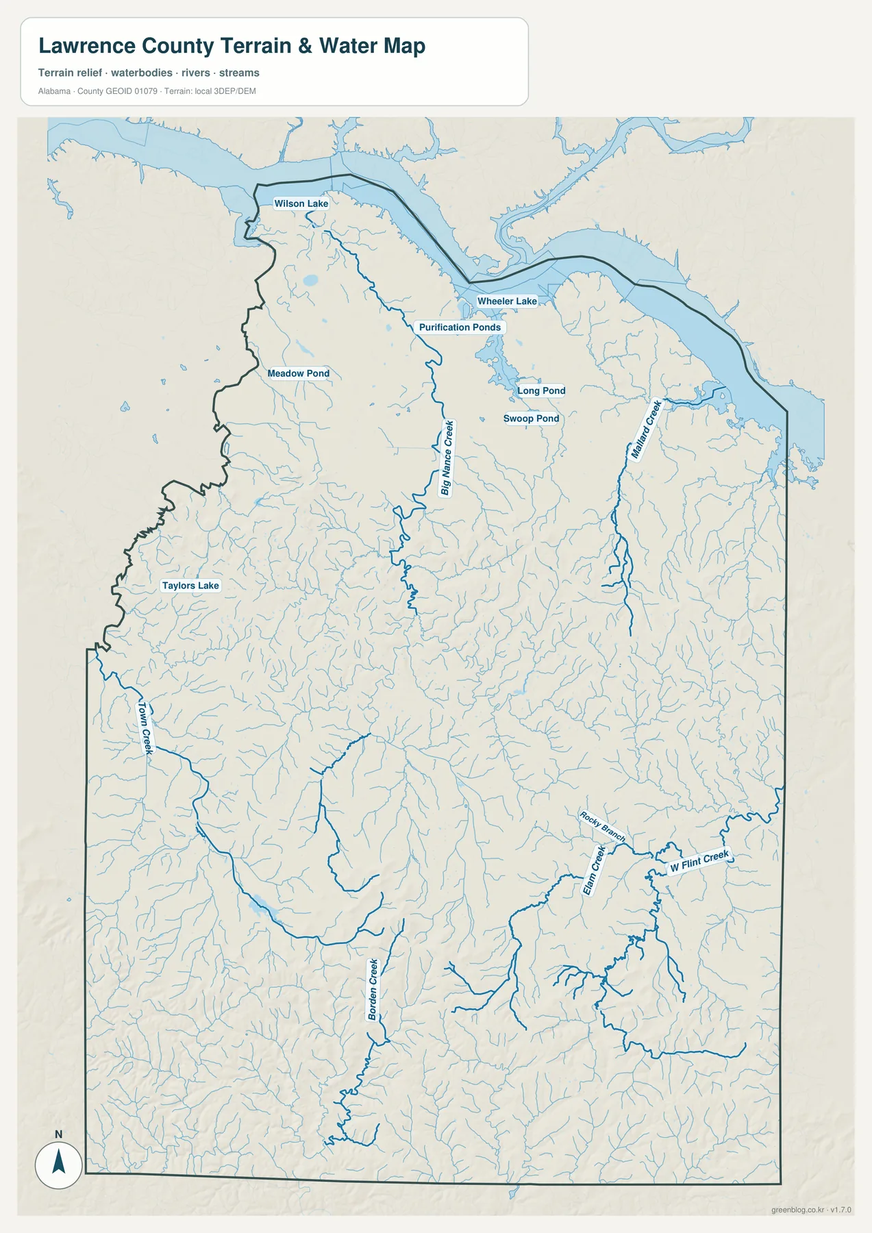
Big Nance Creek is one of the clearest named interior streams. It runs through the northern-central part of the county and gathers many smaller branches. Mallard Creek is prominent in the northeast and reaches the Wheeler Lake side, while Town Creek forms a long drainage on the western side. Farther south, Borden Creek becomes a strong reference line, and the map also labels East Bee Branch, West Flint Creek, and Rocky Branch among a much denser network of smaller channels.
Several smaller water bodies are labeled as well, including Purification Ponds, Long Pond, Swoop Pond, Meadow Pond, and Taylors Lake. They are minor when compared with Wheeler Lake, but they are useful for local orientation in areas where town labels are sparse. The water map is particularly valuable south of Moulton because the general county map can make the forested interior look relatively empty. In reality, those hills and valleys are crossed by many small streams.
Tennessee Valley Authority material describes Wheeler Reservoir as a major Tennessee River impoundment extending through several north Alabama counties. In Lawrence County, it helps shape the county boundary and provides an important geographic reference for the northern settlements. This water map, however, is a reference map for the location of lakes, creeks, and streams. It should not be used as a flood-risk map, legal shoreline map, parcel map, or navigation chart.
Elevation Rising toward the Southern Forested Uplands
The elevation map shows one of the strongest contrasts in Lawrence County. The actual mapped range is about 154 to 333 meters, with a mean near 208 meters. Broad green areas dominate the north around Wheeler Lake, indicating lower terrain. Moving south from that reservoir plain, more yellow, tan, and brown areas appear, and the shaded relief becomes increasingly rugged. The highest terrain is concentrated near the southern boundary, where closely spaced ridges and valleys create a much rougher surface than the northern towns occupy.
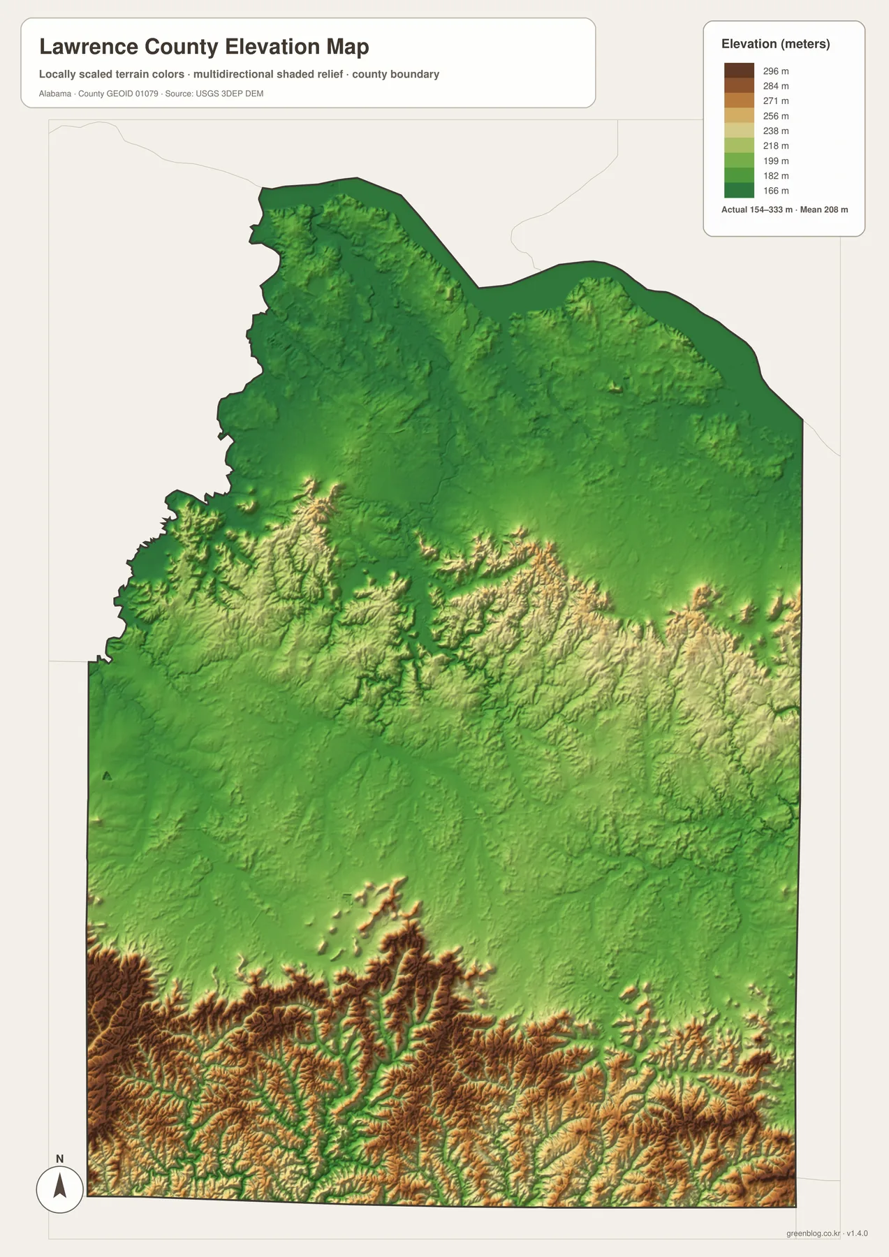
Moulton occupies a middle position in this transition. From town, Alabama 33 runs south toward increasingly rugged land, and the elevation colors change noticeably along that direction. The shaded relief also reveals repeated narrow valleys, not one single mountain ridge. This matches the county background information describing Bankhead National Forest and the Sipsey Wilderness area as a landscape of forested slopes, gorges, waterfalls, and stream valleys.
Courtland, North Courtland, Town Creek, and Hillsboro are all on the lower northern side of the county. Near Wheeler Lake, the terrain is generally smoother and the river-reservoir plain is broader. Small tributaries still cut through the landscape, but the relief is less dramatic than in the south. Comparing this map with the city view helps show why the largest concentration of incorporated towns appears north of the most rugged terrain, even though terrain alone does not determine where people live or roads are built.
The southern elevation map should be read as a generalized surface rather than survey-grade measurement. It is excellent for seeing where the county rises, where valleys cut through the uplands, and how Moulton sits between the lower north and higher south. For engineering, property, or site-specific elevation work, the source data from the U.S. Geological Survey 3D Elevation Program is the better reference.
Choosing a Map for Print, Class, or Local Reference
Start with the general county map when you need orientation. It gives the clearest combination of Moulton, the northern towns, road numbers, the county line, streams, and nearby counties. Switch to the city map when the task is simply to compare the locations and relative sizes of the five ranked cities. The water map is much better for explaining Wheeler Lake and the creek network, while the elevation map is the strongest choice for showing the change from the northern lowlands to the rugged southern hills.
- General county map: useful for Moulton, roads, county boundaries, nearby places, and overall orientation.
- City map: useful for comparing Moulton with Town Creek, Courtland, Hillsboro, and North Courtland.
- Water map: useful for Wheeler Lake, Wilson Lake, Big Nance Creek, Mallard Creek, Town Creek, and smaller tributaries.
- Elevation map: useful for comparing the lower northern reservoir plain with the higher terrain toward Bankhead National Forest.
For a classroom presentation, one effective approach is to pair the city map with the elevation map. The first shows where the principal cities are concentrated, and the second shows the terrain beneath that settlement pattern. For an environmental or geography lesson, the water and elevation maps work well together because the low stream valleys can be compared with the surrounding ridges. The general county map is best for travel orientation, but it is not a real-time navigation product and should not replace current road-condition information.
The downloadable archive contains four A3 JPG files at 3638 by 2572 pixels. They are larger than the WebP previews on the page and are intended for printing, reports, presentations, classroom materials, and other situations where labels need to remain readable. You can open only the map needed for a specific task or keep all four together when comparing roads, settlements, water, and elevation across the same county boundary.
When printing, keep the original aspect ratio and check the printer’s fit-to-page settings so labels or the county boundary are not cropped. For websites or slide decks, a resized copy is often more practical than inserting the full A3 image. These maps are designed for general geographic reference. Legal boundaries, parcel ownership, current road closures, flood hazards, and precise site elevations should be checked against the appropriate government source.
Frequently Asked Questions
Where is Moulton within Lawrence County?
Moulton is the county seat and sits slightly south of the county’s center. Alabama 24 crosses the area, Alabama 33 continues toward the southern uplands, and Alabama 157 links Moulton with the northern part of the county. Because the other ranked cities are concentrated farther north, Moulton is a practical reference point for understanding the county’s road and settlement pattern.
Where is Wheeler Lake on the Lawrence County map?
Wheeler Lake follows the northern side of Lawrence County as part of the Tennessee River system. The water map shows it as the largest water body along the county edge, with Big Nance Creek, Mallard Creek, and smaller tributaries leading toward the reservoir. Using Wheeler Lake as the northern reference makes it easier to orient Courtland, North Courtland, Town Creek, and Hillsboro.
How different is the terrain in southern Lawrence County?
The elevation map shows a clear change. The mapped range is about 154 to 333 meters, with a mean near 208 meters. Land along the Wheeler Lake side is generally lower and smoother, while the southern part of the county contains higher ridges, narrow valleys, and much stronger relief toward the Bankhead National Forest area.
Map File Information
Lawrence County A3 Map Files
- Included Files: Four high-resolution A3 JPG maps
- File Type: JPG files in one ZIP archive
- Intended Use: Printing, education, presentations, and map reference
Related Maps
- Abbeville, Headland, and Lake Eufaula on the Henry County Alabama Map
- Autauga County Map
- Barbour County Alabama Map
Sources and Map Data
- U.S. Census Bureau QuickFacts – Lawrence County, Alabama
- Lawrence County Chamber county overview
- Alabama Department of Transportation map resources
- Tennessee Valley Authority – Wheeler Reservoir
- USGS National Hydrography
- USGS 3D Elevation Program
Green Map creates custom-edited map images using open geographic data sources such as geoBoundaries, Natural Earth, OpenStreetMap, and government open data. These maps are edited visual materials, not raw data files, and are provided for education, documents, presentations, and graphic reference.