A Lauderdale County Alabama Map is especially useful when Florence, the Tennessee River, and the county’s long east-west shape are viewed together. Lauderdale occupies Alabama’s northwestern corner, with Tennessee immediately to the north and Mississippi close to the west. Florence sits near the southern edge on the north side of the Tennessee River, while smaller communities spread east toward Rogersville and north toward Lexington and Anderson. This page includes four map views and a downloadable ZIP containing four high-resolution A3 JPG files for printing, classroom work, trip planning, and local reference.
The maps are meant to complement one another rather than repeat the same information. The main county map combines roads, places, waterways, nearby communities, and the county outline. The city map simplifies the page to six ranked places so their relative positions are easy to compare. A separate water map emphasizes the Tennessee River, Cypress Creek, Shoal Creek, and a dense network of smaller streams, while the elevation map shows how the low river corridor differs from the rolling northern uplands. Together they explain why Florence dominates the south, why the eastern towns follow highway corridors, and why much of the north and west remains more rural.
Table of Contents
Florence, County Edges, and the Northwest Alabama Setting
Lauderdale County reaches the extreme northwest of Alabama. Tennessee forms the northern state line, Mississippi lies off the western side, Limestone County is to the east, and Lawrence and Colbert counties are south of the county. The outline is broad across the north, narrows and bends along the Tennessee River to the south, and extends westward toward Waterloo. That shape matters because the county is not organized around a single central town. Florence is near the southern river edge, while the northern and western countryside stretches a considerable distance away from it.
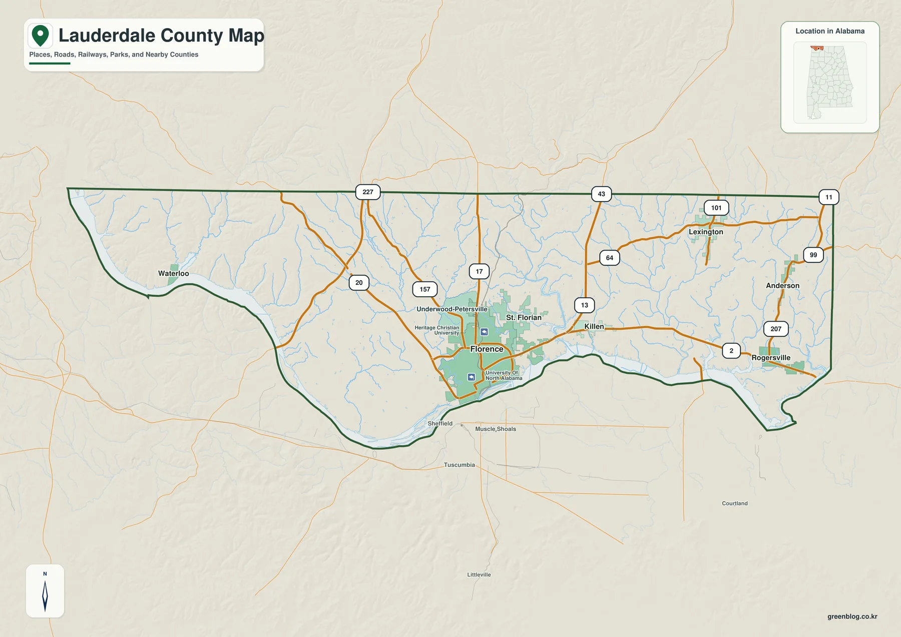
Florence is the county seat and the clearest urban reference point. The map shows a noticeably denser street and development pattern around Florence than anywhere else in the county. The University of North Alabama and Heritage Christian University are labeled near the city, helping locate the built-up area even before individual streets are examined. Across the Tennessee River, Sheffield, Muscle Shoals, and Tuscumbia appear in Colbert County. They are outside Lauderdale County, but their proximity explains why Florence is commonly understood as part of the larger Shoals region rather than as an isolated county-seat city.
U.S. 43 provides the strongest north-south reference through Florence. It connects the city with the Tennessee line to the north and crosses the river toward the Colbert County side of the metro area. U.S. 72 is the main east-west line, running from Florence through Killen and Rogersville toward Limestone County and the Athens-Huntsville direction. The map also labels routes such as Alabama 20, 17, 64, 101, 157, 207, and others that tie rural communities back to Florence and the two principal U.S. highways.
The western side has a much different appearance. Waterloo sits near the river in a sparsely settled part of the county, separated from Florence by long stretches of rural road and stream valleys. The county map makes this contrast visible without needing a population layer: Florence has the densest cluster of roads and developed land, while the west and far north contain fewer named places and much more open space. For orientation, it is helpful to think of Lauderdale as a southern Florence–Shoals urban area attached to a much larger rural interior.
| State | Alabama |
|---|---|
| County | Lauderdale County |
| County seat | Florence |
| 2025 population estimate | 97,135 |
| 2020 census population | 93,564 |
| 2020 land area | 668.01 sq mi |
| 2020 population density | 140.1 per sq mi |
| Key roads shown | U.S. 43, U.S. 72, AL 20, AL 17, AL 64, AL 101, AL 157, AL 207 and others |
| Major waters shown | Tennessee River, Cypress Creek, Shoal Creek, Bluewater Creek and tributaries |
Census figures also help put the map in context. The 2025 population estimate is 97,135, compared with 93,564 people counted in the 2020 census. Lauderdale has 668.01 square miles of land, so the population is spread across a substantial area even though a large share of services and employment is concentrated around Florence. The county therefore combines a regional city with small towns, river communities, and broad rural districts rather than forming one continuous urban area.
Six Labeled Cities and the Road Network Around Them
The city map strips away most of the visual detail and ranks six places: Florence, Rogersville, Killen, St. Florian, Lexington, and Anderson. That simpler view makes the settlement pattern easy to understand. Florence is clearly the dominant center in the south, while the other five places lie mostly to the east and northeast. Waterloo is important on the general map but is not one of the six ranked places in this city view, so it is best to compare both maps when studying the western part of the county.
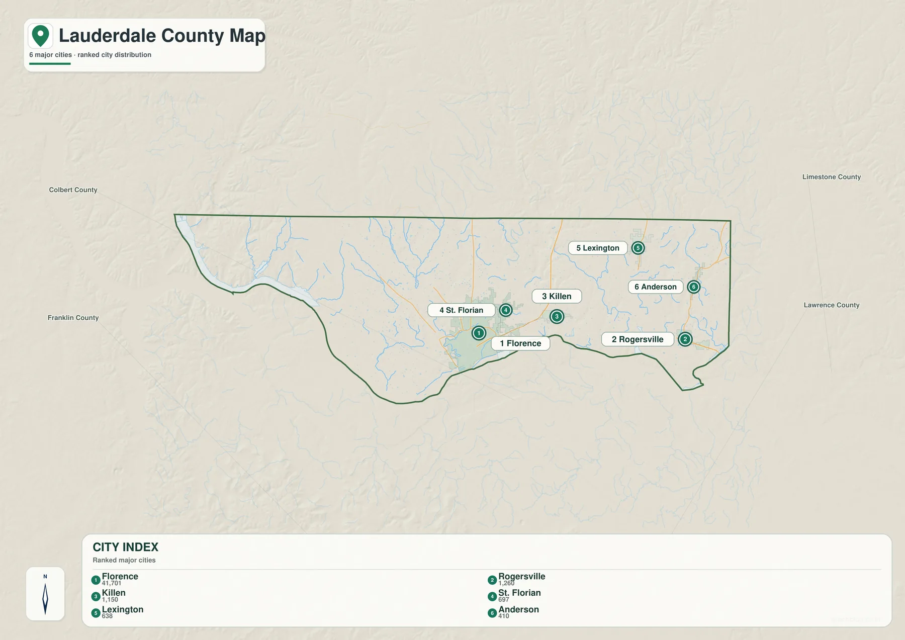
Killen and Rogersville form the most obvious eastern pair. Both are connected to Florence by U.S. 72, but they occupy different positions along the corridor. Killen is closer to the Florence urban edge, while Rogersville is farther east near the Limestone County side. On the general map, that highway continues beyond Rogersville, making it the clearest route for anyone tracing a path from Florence toward Athens and the Huntsville area.
St. Florian sits just northeast of Florence. Its position is useful because it marks the change from the denser Florence road pattern to the more dispersed roads of the interior. Underwood-Petersville, which appears on the general county map rather than the six-city ranking, helps show a similar transition northwest of Florence. These places demonstrate that the Florence urban area does not end at one abrupt line; residential and local-road development gradually gives way to farms, woods, creek valleys, and smaller communities.
Lexington and Anderson are farther north and east, much closer to the Tennessee border than to the riverfront core of Florence. Their road setting is rural, with fewer major routes and a greater reliance on state highways and local roads. Lexington lies near the AL 101 corridor, and Anderson is near the eastern side where AL 207 provides an important connection. For a traveler entering from Tennessee or for a student comparing county settlements, these two towns help define the northern tier of Lauderdale County.
Because there is no Interstate highway cutting through the center of Lauderdale County, U.S. and Alabama routes play an outsized role in local orientation. U.S. 43 and U.S. 72 create the main framework around Florence, while AL 20 carries traffic westward and the numbered state routes distribute travel across the northern and eastern countryside. When printed, the general map is useful for tracing those routes, while the city map is better when the goal is simply to show where the main named communities sit in relation to one another.
Tennessee River, Cypress Creek, and the Smaller Waterways
The Tennessee River is the defining water feature on the Lauderdale County map. It follows much of the southern edge, bends around the western side toward Waterloo, and broadens near the Florence-Shoals area. On the water map, the river is shown as a thick blue corridor, making its scale immediately different from the many narrow tributaries that drain the interior. The map also makes clear that the county’s water system is not limited to one large river; the interior is cut by a dense branching network of creeks and smaller streams.
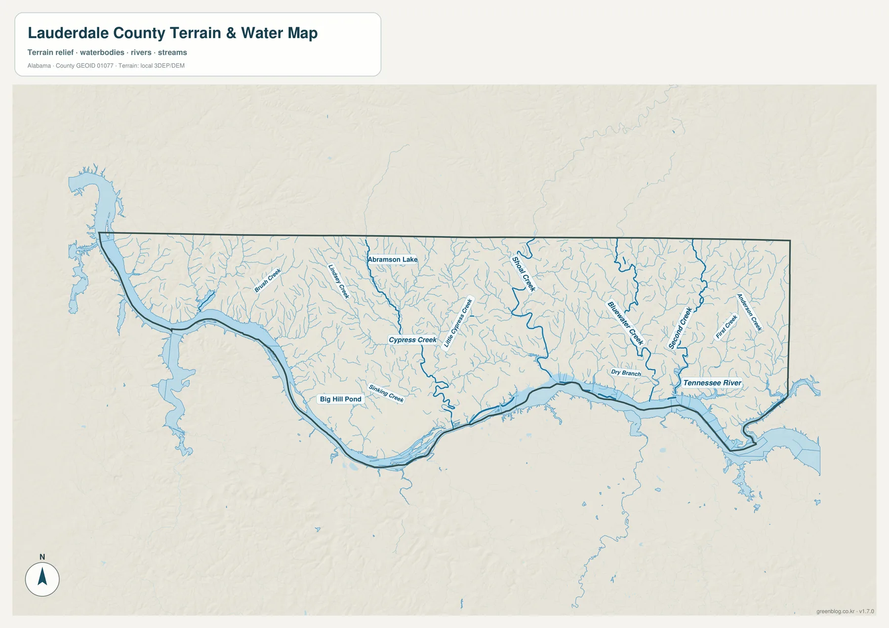
Cypress Creek is one of the most prominent named tributaries. It runs through the central part of the county and gathers water from numerous smaller branches before reaching the Tennessee River system. On the map, the creek and its tributaries create a visible corridor through the interior, which helps explain why nearby roads and settlements do not follow a perfectly regular grid. Stream valleys divide the rolling land and create repeated low routes through otherwise higher terrain.
Farther east, Shoal Creek and Bluewater Creek stand out, along with Second Creek, First Creek, Dry Branch, and many unnamed or less prominent tributaries. Rogersville, Lexington, and Anderson sit within this more dissected eastern landscape. The waterways generally work their way south toward the Tennessee River, so the county can be read as a series of small drainage valleys feeding one much larger river corridor. That is easier to see on the water map than on a standard road map.
Abrahamson Lake and Big Hill Pond are also labeled. They are small compared with the Tennessee River, but they provide useful local reference points in parts of the county where towns are few and road names may be less familiar. For outdoor planning or a classroom lesson, these smaller water bodies make it possible to compare the scale of a pond or lake with the much larger river channel and reservoir-like reaches along the southern edge.
Wilson Dam, between Florence and the Muscle Shoals side of the river, is part of the wider geographic story even when the main purpose is simply to locate the county. TVA records show that the dam was built from 1918 to 1925 and became a major part of navigation, power generation, and industrial development in the Shoals. The river is therefore both a natural boundary and a piece of regional infrastructure. It separates Lauderdale and Colbert counties on paper while also concentrating bridges, travel, employment, and development along both banks.
Elevation from the River Lowlands to the Northern Ridges
The elevation map adds a layer that the city and road maps cannot show. Within the county boundary, elevations on this map range from about 125 meters to 278 meters, with a mean near 193 meters. The lowest greens closely follow the Tennessee River and the larger stream valleys. Higher tan and brown areas are much more common across the north and northeast, where closely spaced ridges and valleys create a visibly rougher surface.
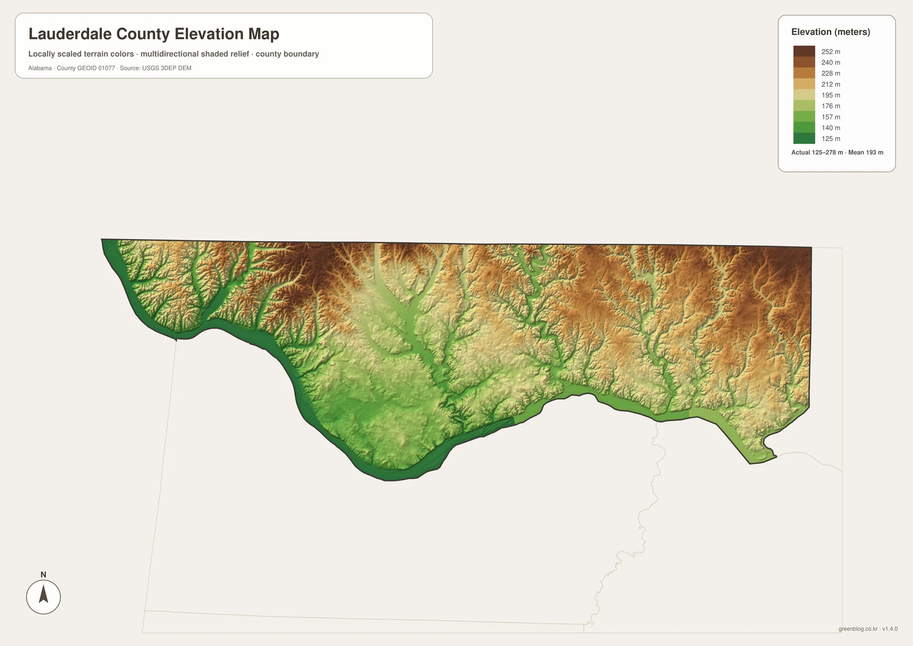
Florence and the river corridor occupy the lower southern part of this pattern. Green colors spread along the Tennessee River and extend into the larger creek valleys, including the central Cypress Creek drainage. This does not mean every part of Florence is at river level; the city occupies higher ground as well. Instead, the map shows a broader contrast in which the major river and tributaries cut lower paths through a rolling landscape.
The northern half is more rugged. Around the Lexington and Anderson side, narrow valleys divide higher uplands, and the shaded relief makes the ridges easy to distinguish. The western interior near Waterloo shows a similar relationship: land beside the river is low, but elevations rise quickly away from the channel. This helps explain why a straight line between two places can cross several ridges and valleys even when the county looks relatively compact on a simple boundary map.
Comparing the elevation and water maps is particularly useful. The darkest green low areas usually line up with the largest rivers and creek bottoms, while higher colors occupy the land between them. A student can use the pair to see how water follows lower terrain, and a traveler can use it to understand why local roads bend through valleys rather than always taking the shortest geometric route. The elevation map is also useful for presentations because it communicates the county’s relief at a glance without requiring detailed contour lines.
Choosing the Best Map for a Print or Reference Task
For a first look at Lauderdale County, start with the general county map. It provides the best combination of the boundary, surrounding places, roads, waterways, and named communities. If the main question is where the larger towns are located, switch to the city map because it removes much of the background detail. For river, creek, or drainage work, the water map is far more informative, and the elevation map is the best choice when the difference between river bottoms and upland terrain matters.
- General county map: best for roads, boundaries, nearby places, and overall orientation.
- City map: best for comparing Florence with Rogersville, Killen, St. Florian, Lexington, and Anderson.
- Water map: best for the Tennessee River, creek valleys, and smaller water bodies.
- Elevation map: best for comparing the low river corridor with the higher northern and northeastern uplands.
The downloadable archive contains all four maps as high-resolution JPG files sized for A3 output. Each image is 3638 by 2572 pixels, providing more detail than the on-page WebP previews. That makes the archive a better choice for posters, lessons, reports, printed travel references, and presentations where labels need to remain legible. You can use a single JPG or place two map types side by side to compare roads with terrain or waterways with settlement patterns.
For printing, keep the original aspect ratio and check the printer’s fit-to-page setting so the map is not cropped. If you are placing a map on a website or in a document, resizing a copy is usually more practical than using the full A3 JPG at its original pixel dimensions. These maps are designed for geographic reference rather than real-time navigation or legal boundary determination, so current road conditions, property boundaries, and official jurisdiction questions should be checked with the appropriate government source.
Frequently Asked Questions
Are Florence and Muscle Shoals in the same county?
No. Florence is in Lauderdale County, while Muscle Shoals, Sheffield, and Tuscumbia are across the Tennessee River in Colbert County. They remain closely connected by bridges, employment, shopping, education, and cultural activity, which is why the communities are often discussed together as the Shoals region.
Why does the Tennessee River matter so much on this county map?
The river shapes much of Lauderdale County’s southern edge, separates Florence from Colbert County, and receives many of the county’s creeks. It also helps explain the location of bridges, Wilson Dam, and the broader Shoals urban area. On the elevation map, the river corridor is among the lowest parts of the county, so it is important for understanding both transportation and terrain.
Which map should I open first?
Begin with the general county map if you are unfamiliar with Lauderdale County because it shows roads, towns, waterways, and the boundary together. Use the city map next for a cleaner view of the principal communities. The water and elevation maps are best when your task focuses on rivers, streams, relief, or the relationship between settlement and terrain. The ZIP download includes all four, so you can move between them as needed.
Map File Information
Lauderdale County A3 Map Files
- Included Files: 4 high-resolution A3 JPG map files shown in this article
- File Type: JPG files in a ZIP archive
- Intended Use: Printing, education, presentations, and map-based projects
Related Maps
- Abbeville, Headland, and Lake Eufaula on the Henry County Alabama Map
- Autauga County Map
- Barbour County Alabama Map
Sources and Data References
- U.S. Census Bureau QuickFacts – Lauderdale County
- U.S. Census Bureau TIGER/Line boundary data
- Alabama Department of Transportation map resources
- USGS National Hydrography
- USGS 3D Elevation Program
- Tennessee Valley Authority – Wilson Dam
Green Map creates custom-edited map images using open geographic data sources such as geoBoundaries, Natural Earth, OpenStreetMap, and government open data. These maps are edited visual materials, not raw data files, and are provided for education, documents, presentations, and graphic reference.