Download the Tuscaloosa County Map as one ZIP containing four original A3 high-resolution JPGs: a county-and-roads map, a six-place ranked city map, a terrain-and-water map, and an elevation map. Tuscaloosa and Northport form the main urban pair on opposite sides of the Black Warrior River, but the county extends far beyond that core. Lake Tuscaloosa and North River define much of the north, while Brookwood, Coaling, Vance, and Lake View help orient the east and southeast. Keeping those subjects in separate maps makes the county easier to understand and gives you larger files for printing or classroom use.
Tuscaloosa County covers a large area, so the central city pair should not be treated as a miniature version of the whole county. Roads and development are concentrated around Tuscaloosa and Northport, while the north contains broad lake and stream country and the west opens into much more rural terrain. The eastern and southeastern communities follow different road corridors, and the elevation map shows that the northern and northeastern parts of the county are noticeably more rugged than the lower southern half. Moving from the general map to the city, water, and elevation views adds detail without crowding everything into one image.
Table of Contents
Start with Tuscaloosa, Northport, and the west-central Alabama setting
Tuscaloosa County lies in west-central Alabama. The supplied background places Fayette and Walker Counties to the north, Jefferson and Bibb to the east, Hale and Greene to the south, and Pickens to the west. That position helps explain why the county connects the Birmingham direction with western Alabama and the Mississippi side while also stretching north into a much less urban lake-and-stream landscape.
| State | Alabama |
|---|---|
| County | Tuscaloosa County |
| County seat | Tuscaloosa |
| 2025 population estimate | 241,368 |
| 2020 census population | 227,036 |
| 2020 land area | 1,320.85 sq mi |
| Major road references | I-20/I-59, U.S. 82, U.S. 43, AL 69, AL 171 |
| Major water references | Black Warrior River, North River, Sipsey River, Lake Tuscaloosa, Holt Lake |
| Elevation shown | Actual 30-237 m, mean 109 m |
The source package gives a July 1, 2025 population estimate of 241,368, compared with 227,036 in the 2020 Census. It also gives a 2020 land area of 1,320.85 square miles. Those figures matter because the compact Tuscaloosa-Northport core occupies only a portion of a very large county. Northern reservoir country, western rural communities, and the southeastern interstate side should therefore be read as distinct areas rather than as uninterrupted extensions of the central city.
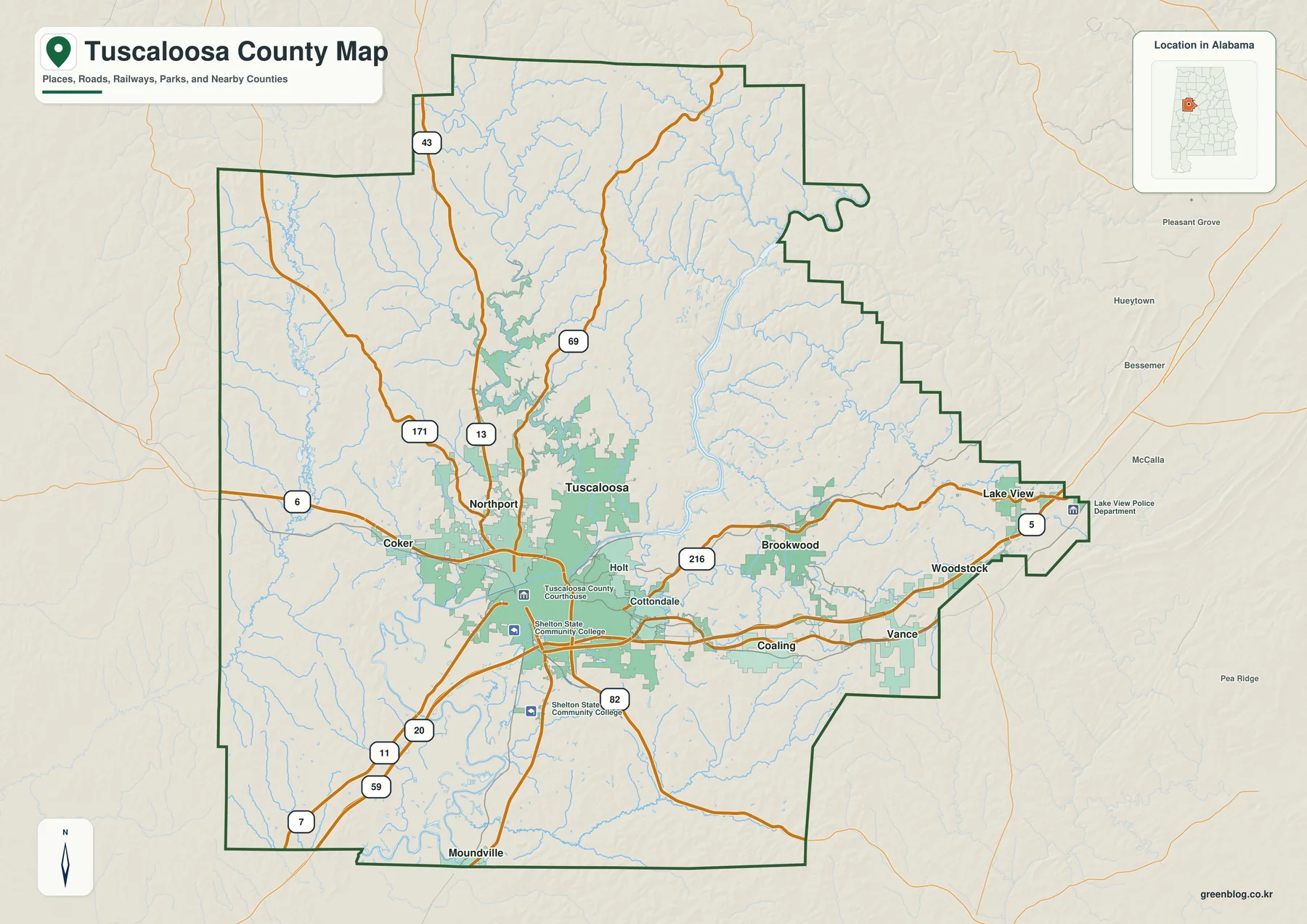
U.S. 82 is the clearest east-west road reference through the urban area, continuing toward Coker on the west and the Brookwood side on the east. U.S. 43 leaves Northport toward the northern county, while Alabama 69 and 171 add northward routes through the interior. I-20/I-59 and U.S. 11 cross the southern side of the Tuscaloosa area, and Route 216 appears as an eastern connection through the Holt-Brookwood direction. The map is easier to use when these broad travel directions are identified before smaller roads are considered.
Six ranked places show a dominant city pair and smaller eastern centers
The city map ranks six selected places. Tuscaloosa is printed at 111,038 and Northport at 31,218, followed by Lake View at 4,063. Brookwood is shown at 2,706, Coaling at 2,573, and Vance at 2,105. These are the values printed on the supplied map, so they work best as a comparison among the selected places rather than as a replacement for a separately dated population table.
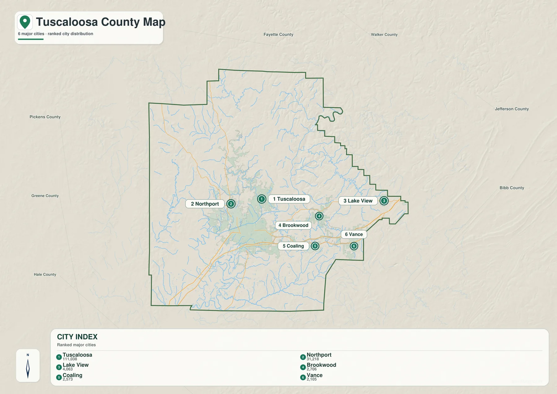
Tuscaloosa and Northport are best understood as a paired urban center rather than two unrelated dots. Their municipal cores sit on opposite banks of the Black Warrior River, with bridges and major roads connecting them. Moving north from that core leads toward the Lake Tuscaloosa watershed, where development becomes less continuous and the water-and-relief setting changes substantially. The city ranking therefore shows size, while the general and water maps explain why the two leading places function as one broad metropolitan area.
The four smaller ranked places occupy a different geography. Lake View lies near the eastern edge, Brookwood follows the U.S. 82 side, and Coaling and Vance are farther south near the interstate corridor. Their positions show that eastern Tuscaloosa County is not one continuous suburban strip. Development is instead separated into communities aligned with different roads, stream valleys, and terrain.
Coker, Holt, Cottondale, Woodstock, Moundville, and other labels remain visible on the general county map but do not appear in the six-place ranking. That distinction is intentional. Use the ranked graphic when relative size and the selected eastern distribution are the main questions; use the general map when the broader network of communities and roads is needed.
Black Warrior River and Lake Tuscaloosa define different water landscapes
The Black Warrior River is the strongest central feature on the water map. Broad water from the Bankhead Lake side reaches the county from the northeast, narrows and continues through Holt Lake, then moves toward the Tuscaloosa-Northport area. Numerous smaller tributaries feed the system along the way. Removing the road and city emphasis makes it much easier to see how the county’s central valleys are organized around the river.
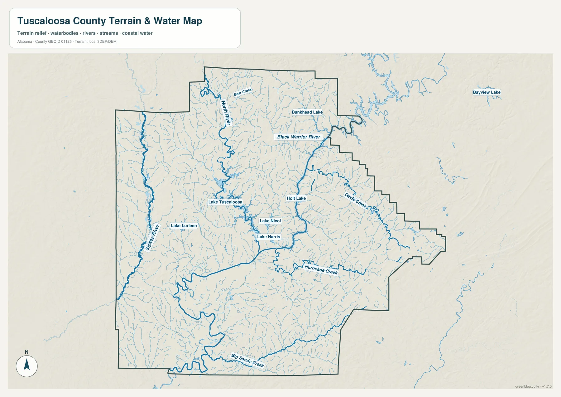
Lake Tuscaloosa belongs to a different part of the county’s water story. The supplied background says it was created in 1970 by damming North River, covers 5,885 acres, and stores about 40 billion gallons. It also identifies the reservoir as Tuscaloosa’s primary drinking-water source. Lake Nicol and Harris Lake are additional named waters in the same broad northern area, so the upper county combines municipal water supply, wooded shorelines, streams, and scattered development.
On the western side, the Sipsey River runs for a long distance through the county, with Lake Lurleen positioned to its east. Davis Creek is prominent on the eastern side, Hurricane Creek crosses the southeast, and Big Sandy Creek appears near the southern boundary. Bear Creek is labeled in the north. These features show that water is not limited to the main urban river; smaller valleys shape much of the county beyond Tuscaloosa and Northport.
The existing article material describes Holt Lake as beginning northeast of Tuscaloosa and extending for about 18 miles with roughly 3,200 surface acres. That context helps distinguish the elongated reservoir reach from the urban riverfront downstream. The map is still a geographic reference rather than a flood, legal-boundary, navigation, or site-drainage product, so specialized tasks require the appropriate official data.
Elevation rises from the southern lowlands into the northern and eastern hills
The elevation map reports an actual range from 30 to 237 meters and a mean of 109 meters. Large areas in the south and around the Black Warrior River appear in lower green tones, while the north and northeast contain more yellow, orange, and brown ridges. The far eastern and northeastern sections are especially textured, creating a strong contrast with the broader low ground south of the urban area.
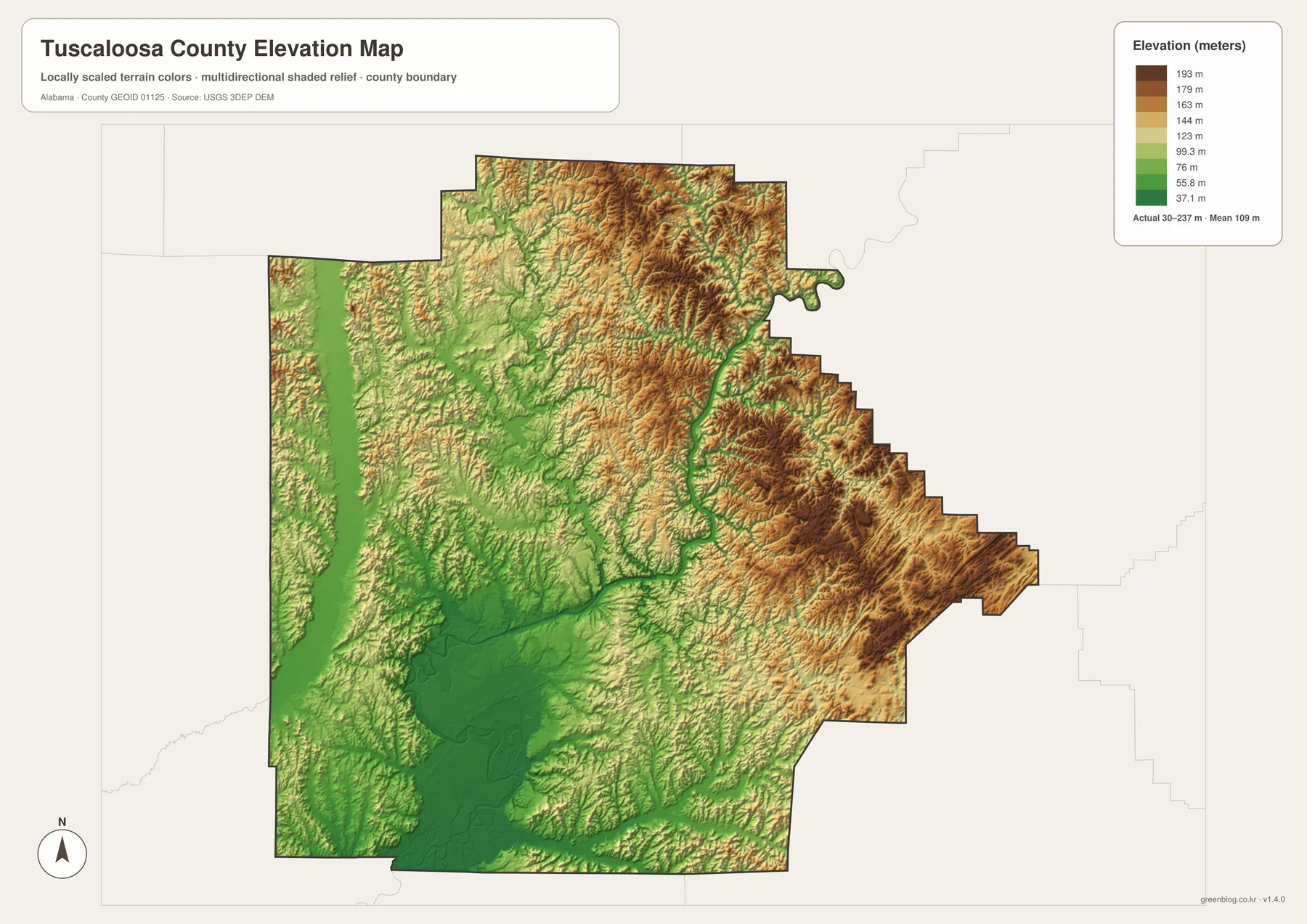
This terrain helps explain why northern roads and streams do not form a simple grid. U.S. 43 and other northward routes pass through country where ridges and drainage valleys repeat, and the northeastern county is noticeably rougher than the south-central lowlands. The general map may make two locations look close in straight-line distance, but the relief layer shows why the route between them can follow a more complicated course.
The western county also alternates between low stream valleys and narrow uplands. Around Lake Tuscaloosa and North River, water occupies lower terrain with higher ground rising nearby. Comparing the water and elevation maps therefore adds a simple physical explanation to the labeled map: major rivers and reservoirs sit in low corridors, while roads and communities must work around the surrounding hills.
This relief map is intended for county-scale comparison. It is useful for teaching, travel context, local orientation, and personal map design when the question is where terrain is relatively high or low. Surveying, construction, engineering, or parcel-level elevation work requires more precise source data.
U.S. 82, U.S. 43, and I-20/I-59 point toward different parts of the county
U.S. 82 is the most useful road for understanding the central east-west relationship. It crosses the Tuscaloosa-Northport area, continues west through the Coker direction, and reaches east toward Brookwood and beyond. U.S. 43 creates the clearest northward line from Northport, while Alabama 69 and 171 provide additional routes toward the northern county. These roads are especially useful when the destination is Lake Tuscaloosa country or a community well outside the urban core.
I-20/I-59 organizes the southern and southeastern side differently. The interstate passes south of central Tuscaloosa and is the key reference for the Cottondale-Coaling-Vance direction. U.S. 11 and roads toward Moundville add southern connections. The map therefore has several major travel frames rather than one universal axis: U.S. 82 for east-west orientation, U.S. 43 for the north, and the interstate for the southern corridor.
Northport’s riverbank position also adds historical context to modern travel. The supplied source material links the city with an early river crossing and navigation point opposite Tuscaloosa. Road traffic now dominates everyday movement, but the Black Warrior River still creates the most obvious physical division between the two municipal centers while bridges keep the pair closely connected.
Choose the Tuscaloosa County map that matches the task
Use the general county map when boundaries, major roads, the Tuscaloosa-Northport core, and a broad selection of communities need to remain visible together. It is the best all-purpose image for tracing U.S. 82, U.S. 43, the interstate, and places such as Coker, Holt, Brookwood, Coaling, Vance, and Moundville. The ranked city map is quicker when the goal is to compare the six selected places without the extra road and place labels.
Choose the water map when Black Warrior River, North River, Sipsey River, Lake Tuscaloosa, Holt Lake, Bankhead Lake, or smaller named waters are the focus. Choose the elevation map when terrain matters more than labels. Its strongest message is the transition from lower southern and river terrain to increasingly hilly northern and northeastern sections.
For printing, classroom work, regional comparison, or a personal map project, the four files work well as complementary references. Begin with place and road orientation, simplify the settlement pattern with the city ranking, then add water and elevation when the physical landscape becomes important. Keeping those functions separate makes each image easier to read while still providing a detailed county set.
Frequently Asked Questions
Why do Tuscaloosa and Northport read as one urban area on the maps?
Their municipal centers face each other across the Black Warrior River and are connected by major roads and bridges. They remain separate cities, but geographic orientation is easier when they are treated as the paired core of the county. The ranked city map shows the size difference, while the general and water maps explain the river relationship.
Is Lake Tuscaloosa part of the Black Warrior River?
The supplied material treats them as different water systems within the county. Lake Tuscaloosa was created by damming North River and serves as Tuscaloosa’s primary drinking-water reservoir, while the Black Warrior River passes between Tuscaloosa and Northport and connects with the Holt and Bankhead reservoir system.
Where is the higher terrain in Tuscaloosa County?
The elevation map places more of the higher and rugged terrain in the north and northeast. Its actual range is 30 to 237 meters with a mean of 109 meters. Much of the south and the main river corridor is lower, so the most useful pattern is the rise from southern lowlands toward the northern and eastern hills.
Map File Information
Tuscaloosa County map files
- Included Versions: county, city, water, elevation
Related Maps
- Abbeville, Headland, and Lake Eufaula on the Henry County Alabama Map
- Athens to Wheeler Reservoir on the Limestone County Alabama Map
- Autauga County Map
Sources and references
- U.S. Census Bureau — 2020 population and land-area background plus the supplied 2025 estimate
- Tuscaloosa County Commission — county government and courthouse reference
- City of Tuscaloosa Lakes Division — Lake Tuscaloosa, Lake Nicol, and Harris Lake background
- U.S. Army Corps of Engineers — Black Warrior-Tombigbee navigation system and Holt/Oliver Lake background
- City of Northport — Northport and Black Warrior River local history context
- USGS 3D Elevation Program — elevation reference
Green Map creates custom-edited map images using open geographic data sources such as geoBoundaries, Natural Earth, OpenStreetMap, and government open data. These maps are edited visual materials, not raw data files, and are provided for education, documents, presentations, and graphic reference.