Download the Walker County Alabama Map as one ZIP containing four original A3 high-resolution JPGs: a county-and-roads map, a six-city ranked map, a terrain-and-water map, and an elevation map. Jasper is the county seat and the main central reference, but the map also spreads west to Carbon Hill, southeast to Cordova, Dora, and Sumiton, and south toward Parrish and Oakman. The waterways and relief matter just as much as the roads because Walker County is cut by the Sipsey and Mulberry Fork systems and by numerous smaller stream valleys.
The county’s settlement pattern is a product of both present-day transportation and older industrial geography. I-22 and U.S. 78 provide the clearest regional route through Jasper, while former mining and railroad communities remain separated across the plateau. On the water map, Blackwater Creek, Rock Creek, Bean River, Lost Creek, and other streams reveal how deeply the land is divided. The elevation map adds the final piece, showing an actual range from 43 to 246 meters with a mean of 144 meters. Together the maps explain why towns that appear close in straight-line position can still occupy different valleys and travel corridors.
Table of Contents
Walker County between Birmingham and northwestern Alabama
Walker County lies in northwestern Alabama. The supplied source material places Winston County to the north, Cullman County to the northeast, Blount and Jefferson Counties to the east, Tuscaloosa County to the south, and Fayette and Marion Counties to the west and northwest. That location puts Walker County between the Birmingham metropolitan side of the state and the more rural northwest. The general map makes this position easy to see because roads converge around Jasper and then spread toward communities at several county edges.
| State | Alabama |
|---|---|
| County | Walker County |
| County seat | Jasper |
| 2025 population estimate | 65,140 |
| 2020 census population | 65,342 |
| 2020 land area | 791.03 sq mi |
| Major roads | I-22, U.S. 78, and connecting state/local routes |
| Major water references | Sipsey Fork, Mulberry Fork, Blackwater Creek, Bean River, and smaller tributaries |
| Elevation shown | Actual 43-246 m, mean 144 m |
The source package gives a July 1, 2025 population estimate of 65,140 and a 2020 census population of 65,342, with 791.03 square miles of land. Those figures provide useful background, but they do not describe a single continuous urban area. Jasper is the strongest center, while smaller communities are widely separated across the county. The spacing visible on the map is consistent with a landscape where mining camps, railroad stops, stream valleys, and later highway connections produced several distinct local centers.
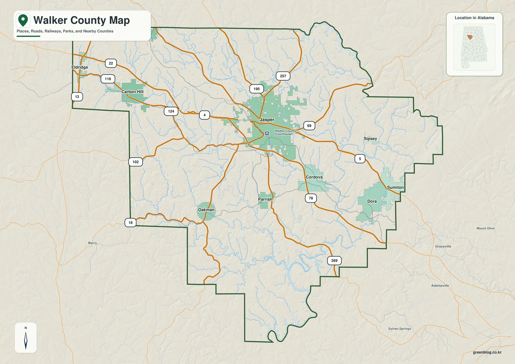
Jasper is the easiest place to use as a road reference because several important routes meet near the center. Westward roads lead toward Carbon Hill and the Fayette-Marion side, while the southeast direction reaches Cordova, Dora, Sumiton, and eventually the Jefferson County side. Parrish and Oakman help locate the southern part of the county. The road network is not a regular grid; it bends around valleys and uplands, which is one reason the same route map becomes more informative after the water and elevation layers are considered.
Six ranked cities show a dominant Jasper and separate outer centers
The ranked city map selects six places. Jasper is printed at 14,442, far ahead of the other entries. Dora follows at 2,668 and Sumiton at 2,459, while Carbon Hill is shown at 1,536, Cordova at 1,511, and Parrish at 1,222. These figures are the values printed on the supplied city graphic, so they are best used to compare the selected places rather than as a replacement for a separately dated population table.
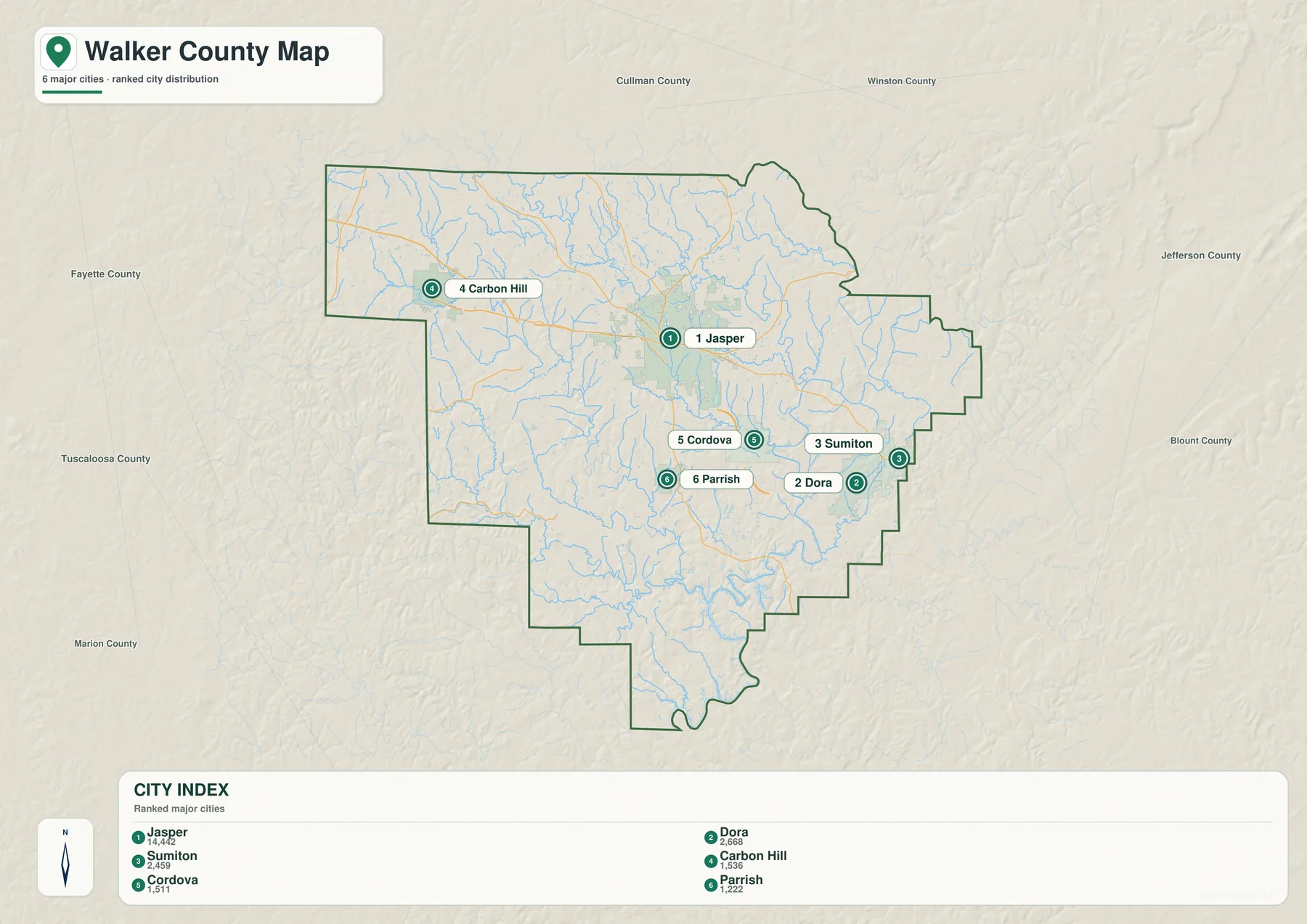
The second- and third-ranked places are notable because Dora and Sumiton lie together near the southeastern edge rather than next to Jasper. Their location is closer to Jefferson County and the Birmingham-facing side of Walker County. Carbon Hill sits far to the west, while Cordova occupies the east-central to southeastern side near the Mulberry Fork system. Similar-sized communities therefore represent very different parts of the county.
Parrish provides a southern reference below Jasper. Oakman, Sipsey, Eldridge, and other labels appear on the general county map but not in the six-place ranking, so the city graphic is not a complete list of municipalities. It is more useful as a simplified comparison of the selected urban centers. When a broader location inventory is needed, the general map should be used alongside it.
The distribution also reflects Walker County’s industrial history. The existing source material places the county within the Warrior Coal Field and connects late nineteenth-century coal, timber, and railroad growth with Jasper, Cordova, Dora, Carbon Hill, and many smaller mining settlements. Present-day populations have changed, but the map still shows how several communities developed as separate centers instead of merging into one broad city.
The Sipsey and Mulberry Forks divide a dense network of smaller streams
The terrain-and-water map makes Walker County look very different from the road map. Sipsey Fork is a major reference on the eastern and northeastern side, while Mulberry Fork is clearly labeled farther southeast. Both belong to the Black Warrior River Basin described in the source material. Between them, a close network of creeks and smaller channels cuts across nearly every part of the county.
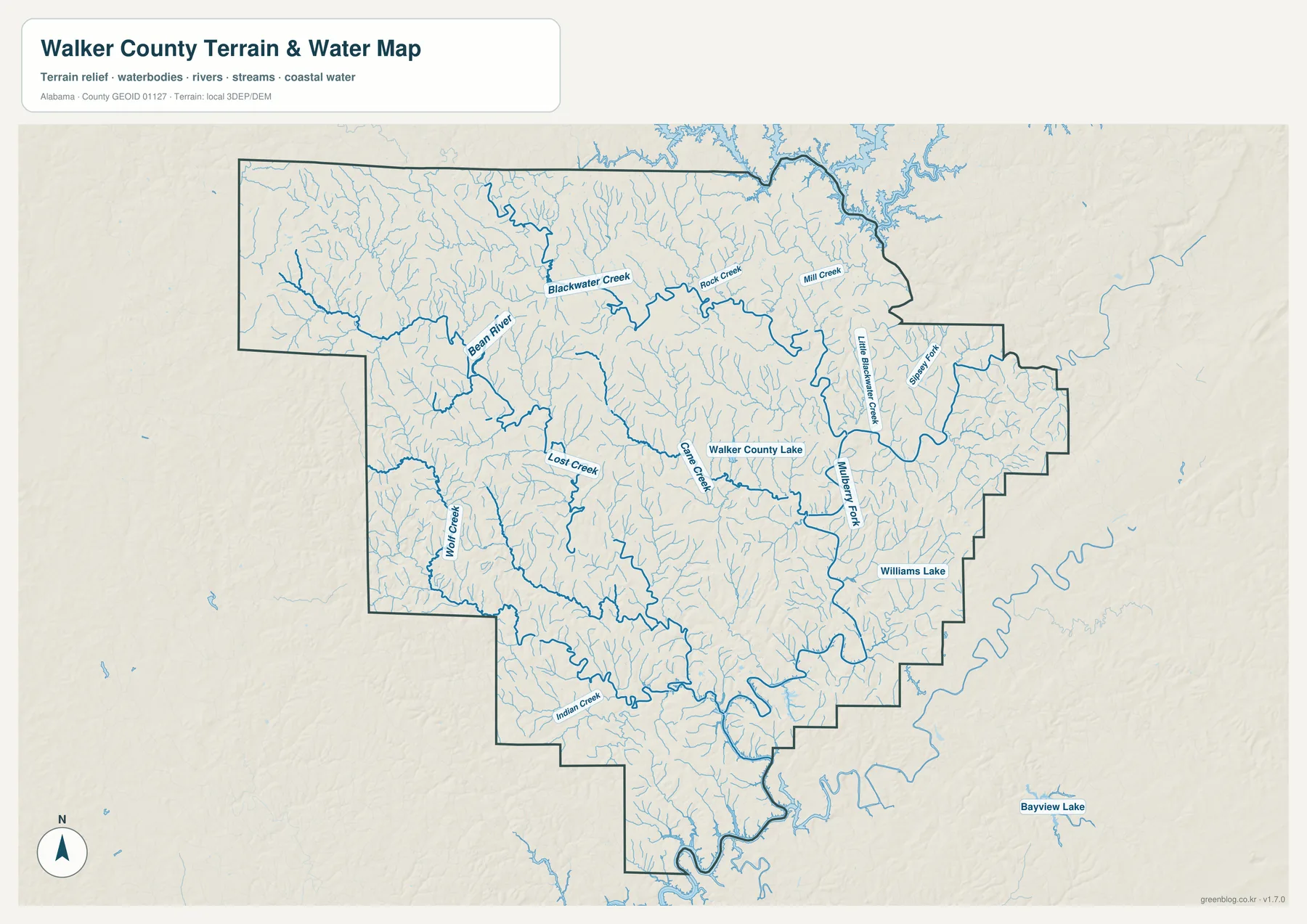
Blackwater Creek and Bean River are useful northwestern references, while Rock Creek and Mill Creek run across the north-central area. Lost Creek appears west of the middle, Cane Creek crosses the interior, and Wolf Creek and Indian Creek help orient the southwest. Little Blackwater Creek is labeled farther east. These names matter because the fine stream network explains why the county’s surface is broken into so many narrow valleys rather than one open plain.
Walker County Lake is labeled near the center, and Williams Lake appears on the eastern side. Large water is also visible beyond the northern county edge. The source package explains that northeastern Walker County is connected with Lewis Smith Lake, a reservoir on the Sipsey Fork shared by Cullman, Walker, and Winston Counties. It is therefore more accurate to treat Smith Lake as a regional upper-basin feature than as a lake contained entirely within Walker County.
The water map is intended for geographic reference. It works well for finding named streams and lakes and for comparing different parts of the Black Warrior drainage, but it is not a flood-risk map, legal water-boundary record, navigation chart, or site-specific drainage study. Those uses require more specialized and current data.
Elevation reveals high northern uplands and deeply cut stream valleys
The elevation map reports an actual range from 43 to 246 meters and a mean of 144 meters. Higher brown and tan terrain is widespread across the north and northwest, while lower green corridors follow streams through the center and south. The eastern and southeastern sides also contain repeated ridges and valleys, giving the county a textured surface rather than a broad flat floor.
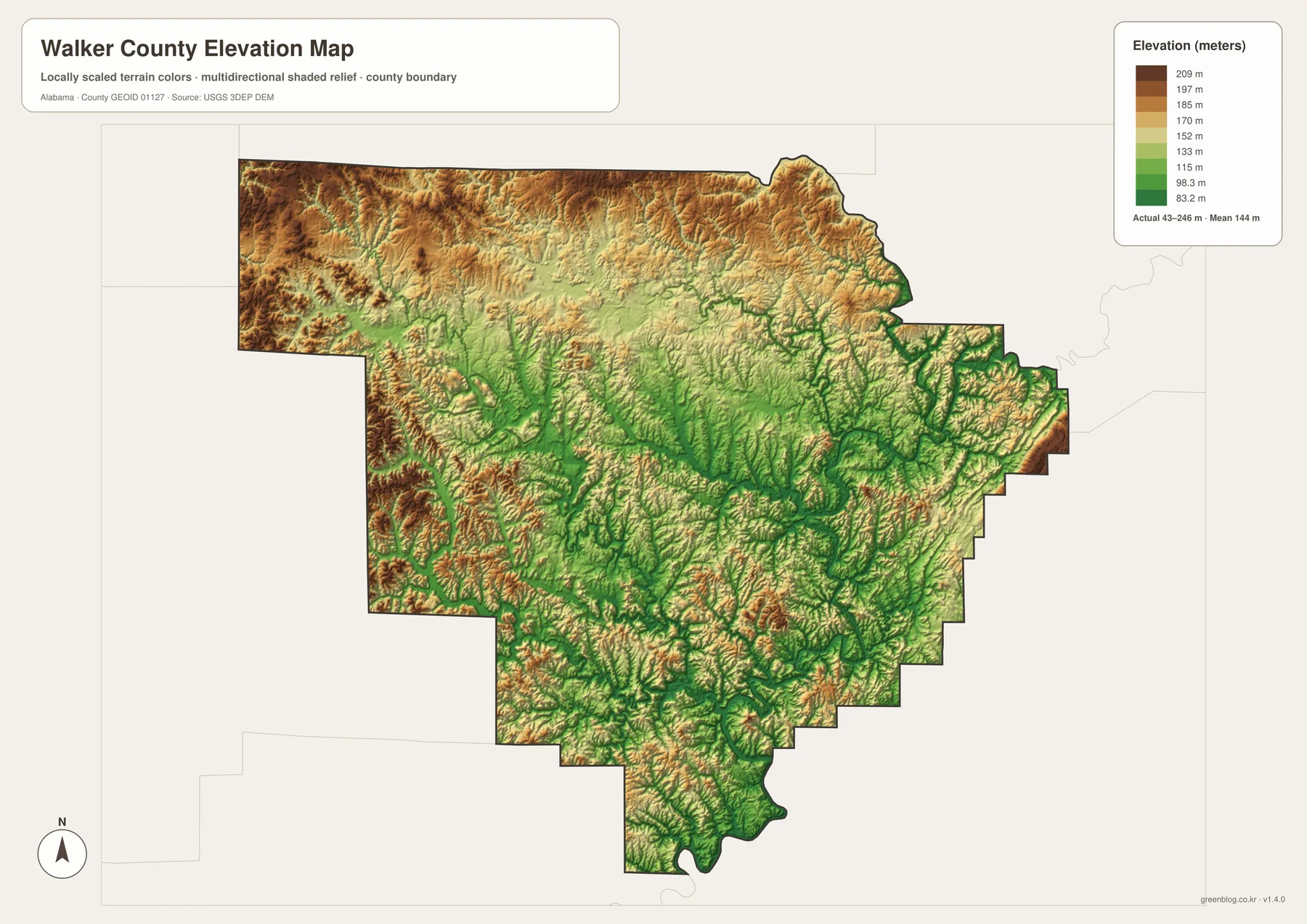
The supplied background identifies Walker County with the Cumberland Plateau section of the Appalachian Highlands. That description fits the relief image well: broad uplands are repeatedly cut by narrow valleys rather than rising into a few isolated mountain peaks. Pine and oak woodland is also part of the county background in the source material. The shape of the terrain helps explain why roads, rail corridors, and settlements often follow lower passages instead of crossing the highest ridges directly.
The same terrain is relevant to the county’s coal history. Coal seams of the Warrior Coal Field, stream valleys, and rail access contributed to the locations of industrial communities such as Carbon Hill, Cordova, and Dora. The elevation map does not identify coal seams or historical rail lines directly, but it supplies the physical background that makes their separated locations easier to understand. It should not be treated as survey-grade elevation for a parcel, construction site, or engineering calculation.
I-22 and U.S. 78 connect a landscape shaped by coal and railroads
I-22 is Walker County’s clearest modern regional highway. The official county source in the package states that roughly 42 miles of interstate cross the county and describes I-22 as part of the Birmingham-Memphis route. U.S. 78 remains another important east-west reference through Jasper. Once those two roads are located, the western Carbon Hill side and the Cordova-Dora-Sumiton side are much easier to place.
Railroads and mining belong to an earlier transportation era, but they remain important for explaining why the settlement map looks the way it does. Coal and timber expansion in the late nineteenth century brought railroad construction and mining camps to different valleys, while Jasper grew as the county’s administrative and commercial center. Carbon Hill, Cordova, and Dora developed in other industrial settings, leaving Walker County with several separated towns instead of one continuous built-up area.
The southeastern Dora-Sumiton area is closer to Jefferson County and the Birmingham side, while Carbon Hill gives the map a western reference toward Fayette and Marion Counties. Jasper occupies the middle of those directions, and Cordova sits near the Mulberry Fork side of the county. This is why the road map and the city map answer different questions: one explains travel connections and the other simplifies the relative size and distribution of selected communities.
Choose the Walker County map that matches the job
The general county map is the best starting point when boundaries, roads, streams, and a broad set of place names must remain visible together. It is useful for locating Jasper, Carbon Hill, Cordova, Dora, Sumiton, Parrish, Oakman, and Sipsey while keeping the main road directions in view. The ranked city map is faster when the goal is simply to compare the six selected places and see how much larger Jasper is than the other entries.
Choose the water map when the Sipsey Fork, Mulberry Fork, Blackwater Creek, Bean River, or smaller streams and lakes are the focus. Choose the elevation map when the main question is terrain: its strongest pattern is the contrast between higher northern uplands and the low, branching stream valleys that cut through the county. Comparing the water and relief layers also makes it easier to see how many of the lowest corridors follow waterways.
For teaching, printing, regional comparison, or personal cartography, the four files work well as complementary references. Start with the county map for location and travel, use the city map for the settlement hierarchy, then add water and elevation when the physical landscape becomes important. Keeping those subjects separate avoids the clutter that would result from putting every label and terrain layer into a single image.
Frequently Asked Questions
What is the county seat of Walker County?
Jasper is the county seat. It sits near the center of the general map where several important roads meet, and it also has the highest printed value on the six-city ranking at 14,442. Those two roles make Jasper the easiest starting point for orienting the rest of the county.
Is Lewis Smith Lake entirely inside Walker County?
No. The supplied source material describes Lewis Smith Lake as a reservoir on the Sipsey Fork shared by Cullman, Walker, and Winston Counties. It is part of the northeastern water setting but should not be treated as a lake contained only within the Walker County boundary.
Is Walker County mostly flat?
No. The elevation map reports an actual range of 43 to 246 meters and a mean of 144 meters. Higher uplands are widespread in the north and northwest, while lower stream valleys cut through the center and south, which fits the county’s Cumberland Plateau setting.
Map File Information
Walker County map files
- Included Versions: county, city, water, elevation
Related Maps
- Abbeville, Headland, and Lake Eufaula on the Henry County Alabama Map
- Athens to Wheeler Reservoir on the Limestone County Alabama Map
- Autauga County Map
Sources and references
- U.S. Census Bureau QuickFacts — Walker County, Alabama — population and area background
- Walker County, Alabama official website — county government and I-22 transportation context
- Encyclopedia of Alabama — Walker County — Cumberland Plateau, mining, railroad, and regional background
- Encyclopedia of Alabama — Lewis Smith Dam and Lake — Smith Lake and Sipsey Fork context
- USGS National Hydrography — water-feature reference
- USGS 3D Elevation Program — elevation reference
Green Map creates custom-edited map images using open geographic data sources such as geoBoundaries, Natural Earth, OpenStreetMap, and government open data. These maps are edited visual materials, not raw data files, and are provided for education, documents, presentations, and graphic reference.