Download the Washington County Alabama Map as one ZIP containing four original A3 high-resolution JPGs: a county-and-roads map, a Chatom-centered city-connections map, a terrain-and-water map, and an elevation map. Washington County stretches between the Mississippi state line on the west and the Tombigbee River on the east. Chatom provides the inland administrative reference, Millry anchors the north, and McIntosh sits much closer to the southeastern river corridor. Looking at those places together with waterways and relief gives a much clearer picture than a single boundary map can provide.
This is a large, lightly populated rural county rather than a continuous urban area. The source package gives a 2025 population estimate of 14,822, a 2020 population of 15,388, and 1,080.20 square miles of land. McIntosh, St. Stephens, and Leroy belong to the eastern Tombigbee side, while Chatom, Millry, and Fruitdale are better understood through the inland road network. The Escatawpa River creates a separate drainage system in the west and southwest, so even the county’s water does not all move toward the same river.
Table of Contents
A county framed by Mississippi on the west and the Tombigbee on the east
Washington County occupies southwestern Alabama. Choctaw County lies to the north, Clarke County to the east, and Mobile County to the south, while Mississippi forms the western state boundary. The contrast between the two sides is obvious on the general map: the western edge is comparatively straight, but the eastern boundary bends with the Tombigbee River and its lowland landscape. That makes the county easy to orient once those two edges are identified.
| State | Alabama |
|---|---|
| County | Washington County |
| County seat | Chatom |
| 2025 population estimate | 14,822 |
| 2020 census population | 15,388 |
| 2020 land area | 1,080.20 sq mi |
| 2020 population density | 14.2 per sq mi |
| Major road references | U.S. 43, U.S. 45, AL 17, and connecting local routes |
| Major water references | Tombigbee River, Escatawpa River, and numerous creeks and lakes |
| Elevation shown | Actual 1-130 m, mean 44 m |
The low population density helps explain why town labels are widely separated. Chatom is the county seat, but it does not sit inside a large continuous built-up area. Millry, Fruitdale, McIntosh, Leroy, St. Stephens, and other communities are divided by broad rural land and stream basins. For practical map reading, the most useful first step is to locate those communities in relation to major roads and waterways rather than expecting a dense street network.
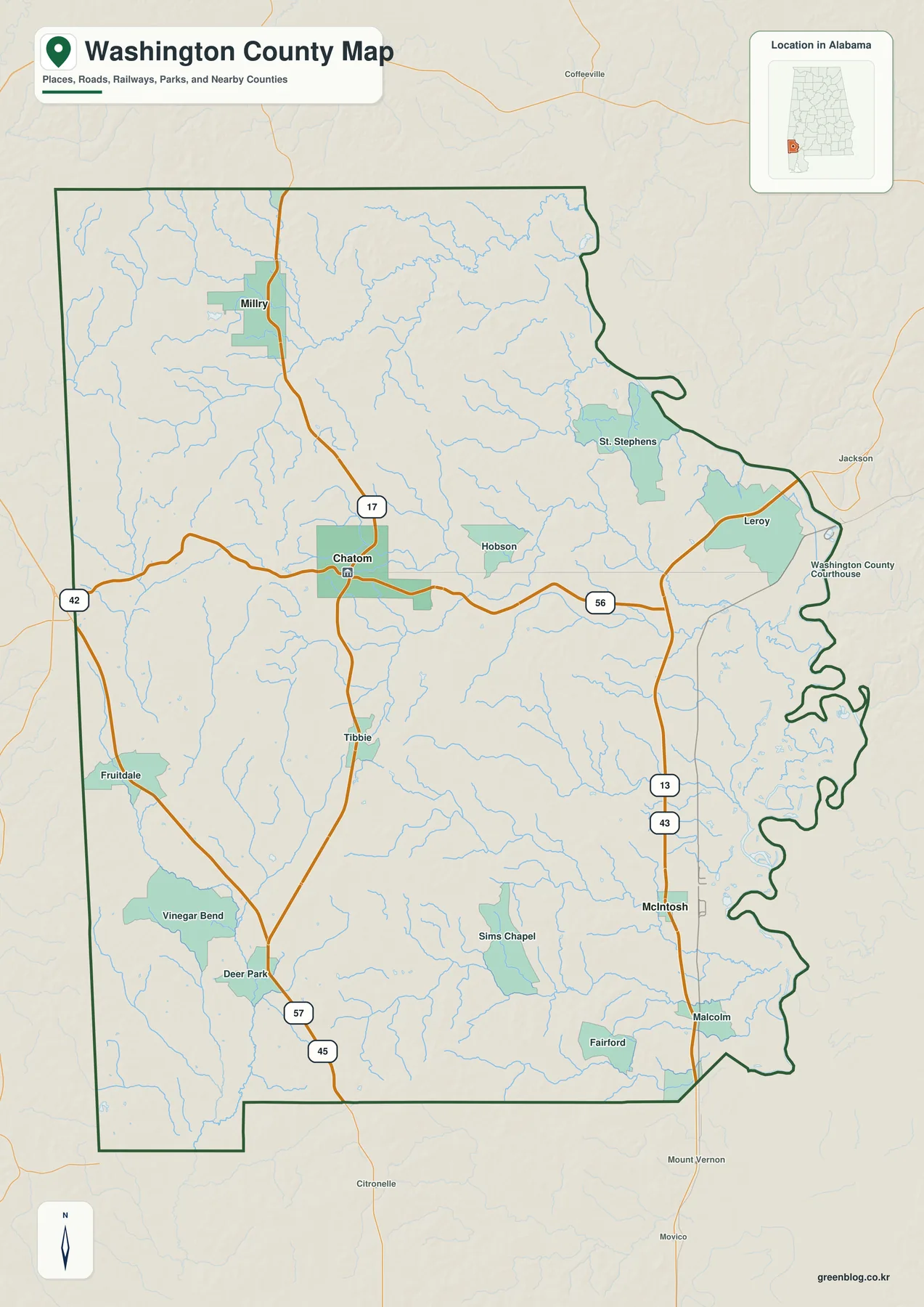
Chatom is the easiest inland road reference. Alabama 17 connects the Chatom area with Millry to the north, while eastbound local routes lead toward Leroy and the Tombigbee side. U.S. 43 runs north-south through the eastern part of the county near McIntosh, tying the river corridor toward Mobile and Clarke County. U.S. 45 provides a southwestern reference toward Mississippi and Mobile County, and the map also shows numbered routes such as 42 and 57 around the western side.
Chatom connects the northern interior with the southeastern river side
The city-connections map intentionally reduces the county to three selected places so distance and direction are easy to see. Its index prints Chatom at 834, Millry at 520, and McIntosh at 364. More importantly, the connector labels place Millry about 21 miles from Chatom and McIntosh about 20 miles from Chatom. Those are straight-line distances, not driving distances, so actual road travel will depend on the route taken.
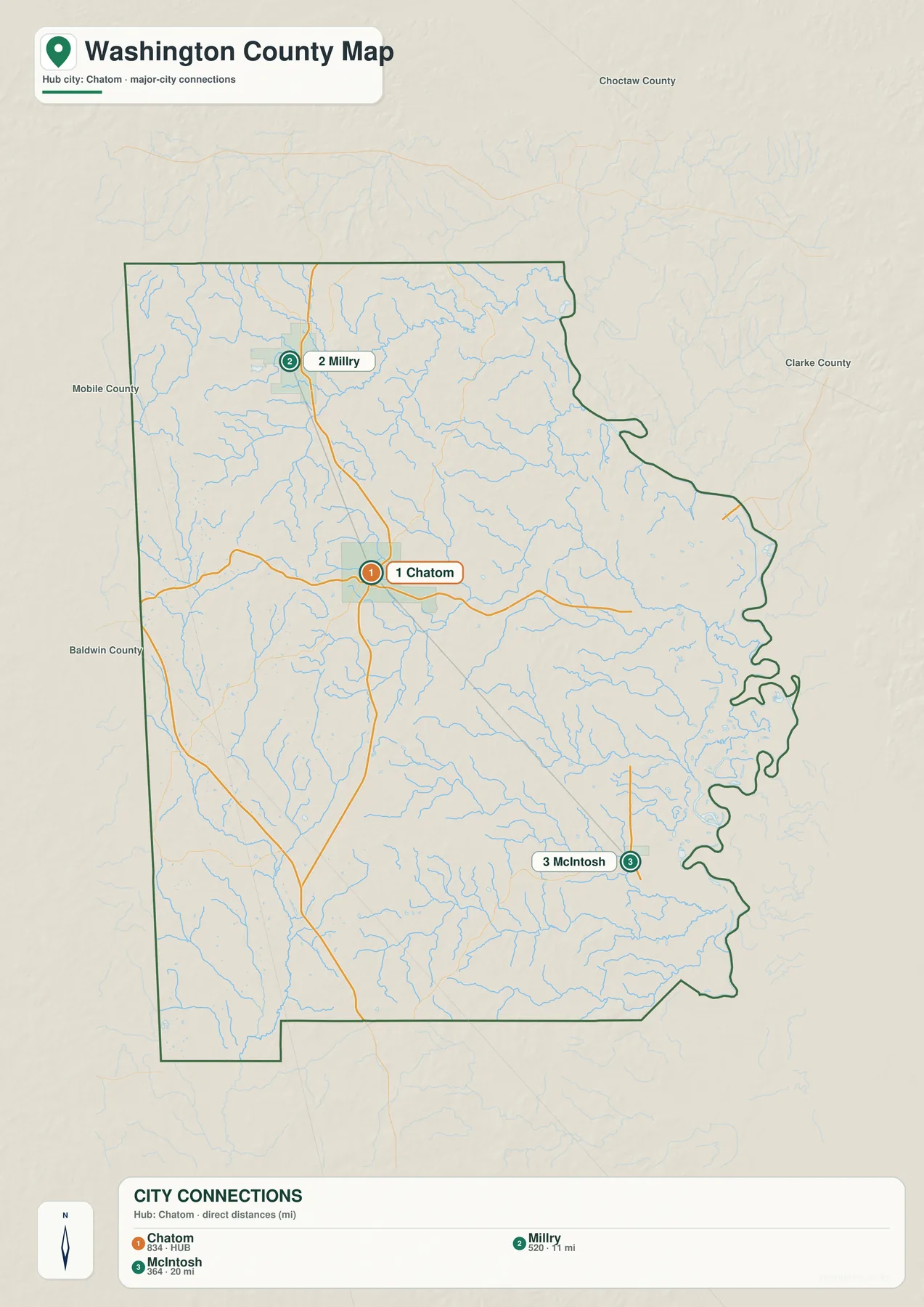
The similar distance figures can be misleading if geography is ignored. Millry lies north of Chatom in the inland part of the county, while McIntosh is southeast and much closer to the Tombigbee corridor and U.S. 43. The existing source material describes a large natural salt dome beneath the McIntosh area and notes that salt mining and chemical production expanded there beginning in the 1950s. McIntosh therefore represents an industrial river-and-highway setting that differs sharply from the more administrative role of inland Chatom.
Chatom has served as the county seat since 1907 according to the supplied background. On the map it is useful less as a large-city marker than as a central point for finding Millry, McIntosh, Fruitdale, Leroy, and St. Stephens. The city-connections graphic is not a complete municipality list; it is a simplified way to compare a northern interior place and a southeastern river-side place from the same hub.
The Tombigbee and Escatawpa systems send water in different directions
The eastern edge is dominated by the Tombigbee River. McIntosh, St. Stephens, and Leroy all sit closer to this side of the county, where the broad river and its lowlands form a strong geographic boundary. Western Washington County tells a different story. The source package describes the Escatawpa River as beginning within Washington County less than a mile from the Mississippi line and flowing southward rather than east toward the Tombigbee. That distinction prevents the county from being reduced to one simple river basin.
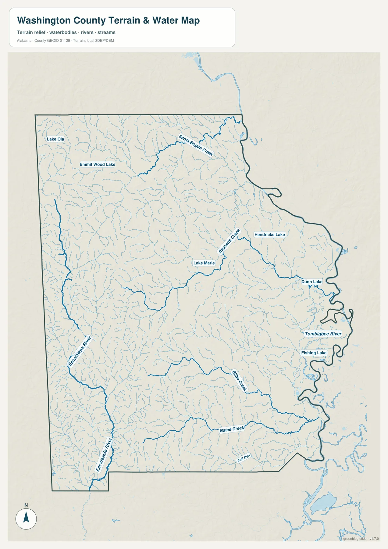
The dedicated water map adds names that are difficult to notice on the general county image. Lake Ola and Emmitt Wood Lake appear in the north, and Santa Bogue Creek runs across the northeastern interior. Bassetts Creek and Lake Marie provide central references, with Hendricks Lake and Dunn Lake farther east. Bilbo Creek and Bates Creek are prominent in the south, while Fishing Lake sits close to the Tombigbee side. Smaller channels fill the spaces between these labeled features.
St. Stephens adds historical meaning to the eastern river corridor. The supplied Washington County background describes the settlement on a limestone bluff above the Tombigbee, notes that it once served as the capital of Alabama Territory, and identifies it as one of the county’s former seats. Comparing that river-oriented location with modern inland Chatom helps explain how government and transportation priorities changed over time.
The water map is a geographic reference rather than a regulatory product. It is useful for locating rivers, creeks, and lakes and for comparing the eastern and western drainage systems, but it should not be used as a flood-risk map, parcel boundary source, boating chart, or site-specific drainage study. Those tasks require more specialized current data.
Elevation falls toward the Tombigbee lowlands and rises across the west
The elevation map shows an actual countywide range from 1 to 130 meters and a mean of 44 meters. Darker green low terrain is widespread along the eastern Tombigbee side, while tan and brown uplands become more common toward the west and northwest. The center is a mixture of gentle ridges and stream-cut low corridors. The overall relief is modest compared with mountainous northern Alabama, but the east-west difference is still obvious.
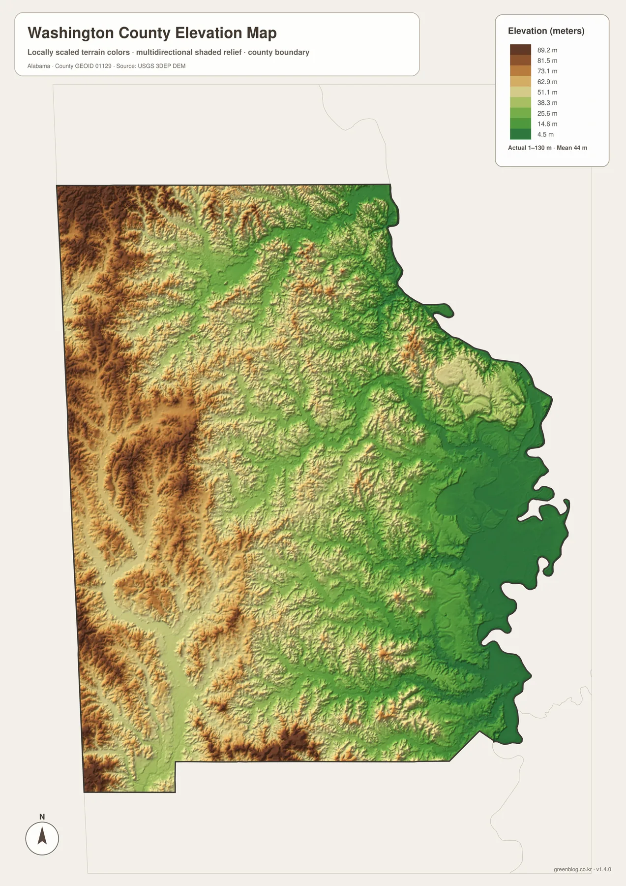
The existing county material places Washington County in Alabama’s Coastal Plain and describes extensive pine forest and generally low, gently rolling terrain. The relief image fits that description. It does not show a few dominant peaks; instead, modest ridges are repeatedly divided by stream valleys. Comparing the elevation and water maps also makes it easy to see that many of the darkest low corridors follow rivers and creeks.
This relief map is intended for county-scale comparison. It is useful for explaining which parts of Washington County are relatively low or high and for adding terrain context to roads and waterways. It is not survey-grade elevation for a parcel, construction site, engineering design, or drainage calculation, where more precise source data would be required.
U.S. 43 serves the river corridor while Chatom anchors the inland road network
The eastern transportation pattern is easiest to understand with U.S. 43. It runs north-south through the McIntosh side of the county and provides a clear connection toward Mobile and Clarke County. Leroy and St. Stephens also belong to the eastern half where the Tombigbee is an important geographic reference. In McIntosh, the relationship among highway access, river proximity, rail transportation, and the salt-based industrial history described in the source package gives the community a role very different from Chatom’s.
Chatom sits inland from that river corridor. Alabama 17 leads north toward Millry, and east-west local roads connect the county seat toward Leroy. The southwestern side turns toward Fruitdale, U.S. 45, Mississippi, and Mobile County. These different travel directions help explain why a county with a small population can still have several recognizable local centers spread over a large area.
The communities are also useful for understanding historical change. Chatom represents modern county administration, McIntosh represents a river-and-industry setting, and St. Stephens represents an earlier period when the Tombigbee was closely tied to government and trade. Millry and Fruitdale help fill in the inland north and west. Reading place names through roads and waterways produces a more useful county picture than treating each label as an isolated dot.
Choose the Washington County map according to the detail you need
Use the general county map when boundaries, major roads, streams, and a broad selection of place names need to remain visible together. It is the best all-purpose reference for locating Chatom, Millry, McIntosh, Leroy, St. Stephens, and Fruitdale between the Mississippi line and the Tombigbee side. The city-connections map is simpler when the main question is how Millry and McIntosh relate to Chatom; remember that its 21-mile and 20-mile labels are straight-line distances rather than road mileage.
Choose the water map when the Tombigbee River, Escatawpa River, Santa Bogue Creek, Bassetts Creek, Bilbo Creek, Bates Creek, or named lakes are the focus. Choose the elevation map when the main question is terrain rather than labels. Its most visible pattern is the transition from low eastern river country to somewhat higher rolling ground in the west and northwest.
For teaching, printing, regional comparison, or a personal map project, the four files work best as complementary references. Begin with the county map for orientation, use the city graphic for distance and direction from Chatom, then add water and elevation when the physical landscape matters. Separating those subjects keeps each image readable while still allowing the set to describe a large rural county in detail.
Frequently Asked Questions
What is the county seat of Washington County?
Chatom is the county seat. The supplied background says it has served in that role since 1907. Its inland location also makes it a convenient map reference for finding Millry to the north, McIntosh to the southeast, and other communities in different parts of the county.
How far are Millry and McIntosh from Chatom on the city map?
The map labels Millry at about 21 miles from Chatom and McIntosh at about 20 miles. These are straight-line distances, so road mileage can be longer depending on the route.
Which river system matters besides the Tombigbee?
The Escatawpa River is the important western and southwestern counterpart. The supplied source material says it begins in Washington County close to the Mississippi line and flows southward, while the eastern side is organized around the Tombigbee River and its tributaries.
Map File Information
Washington County map files
- Included Versions: county, city, water, elevation
Related Maps
- Abbeville, Headland, and Lake Eufaula on the Henry County Alabama Map
- Athens to Wheeler Reservoir on the Limestone County Alabama Map
- Autauga County Map
Sources and references
- U.S. Census Bureau QuickFacts — Washington County, Alabama — population, land area, and density background
- Encyclopedia of Alabama — Washington County — Chatom, St. Stephens, Coastal Plain, waterways, and local history
- Encyclopedia of Alabama — McIntosh — salt dome, industry, and Tombigbee River setting
- Alabama Department of Transportation — Washington County Highway Map — road and community layout
- USGS National Hydrography — water-feature reference
- USGS 3D Elevation Program — elevation reference
Green Map creates custom-edited map images using open geographic data sources such as geoBoundaries, Natural Earth, OpenStreetMap, and government open data. These maps are edited visual materials, not raw data files, and are provided for education, documents, presentations, and graphic reference.