Lawrence County is centered on Bedford, with Oolitic immediately to the north, Mitchell farther south, and smaller communities spread through a deeply cut hill-and-creek landscape. You can download the high-resolution JPG ZIP directly from this page when you need larger road shields, creek names, settlement labels, or elevation shading. This Lawrence County Indiana Map page connects the Bedford road network with the short Bedford–Oolitic and Bedford–Mitchell city distances, the Leatherwood and Salt Creek systems, and a 141–285 meter relief surface.
Bedford is the easiest place to use for orientation because U.S. 50 runs across the center and Route 37 passes north-south through the Bedford–Oolitic–Mitchell corridor. Williams lies to the west, Heltonville to the northeast, and Tunnelton and Lawrenceport provide references in the southeast. Avoca, Needmore, and Judah occupy the northern interior, where the road pattern becomes more rural and creek valleys increasingly shape the map.
The terrain views reveal a much rougher county than the road map suggests. The elevation legend gives an actual range of about 141 to 285 meters and a mean of 201 meters. Low green creek valleys wind through the middle and north, while high brown ridge groups rise along the western side, across the northeast, and again in the southwest. Leatherwood Creek, Little Salt Creek, Back Creek, Guthrie Creek, and other channels repeatedly cut into those uplands.
Table of Contents
Bedford anchors the U.S. 50 and Route 37 road framework
Bedford has the largest developed footprint on the general map. U.S. 50 crosses the city and continues east as the 50E corridor, while Route 37 runs north toward Oolitic and south toward Mitchell. Indiana University Health Bedford is labeled on the western side of the city and provides another easy visual reference. Lawrence County’s official site identifies Bedford as the county seat and its largest city, which matches the strong central role it plays on the map.
Oolitic is just north of Bedford near the Route 37 corridor. Needmore, Avoca, and Judah sit farther north and northwest, with Route 54 leading toward Avoca and Route 458 approaching the Bedford side. The developed areas remain separate rather than merging into one continuous urban strip, and small streams and hills occupy the spaces between them.
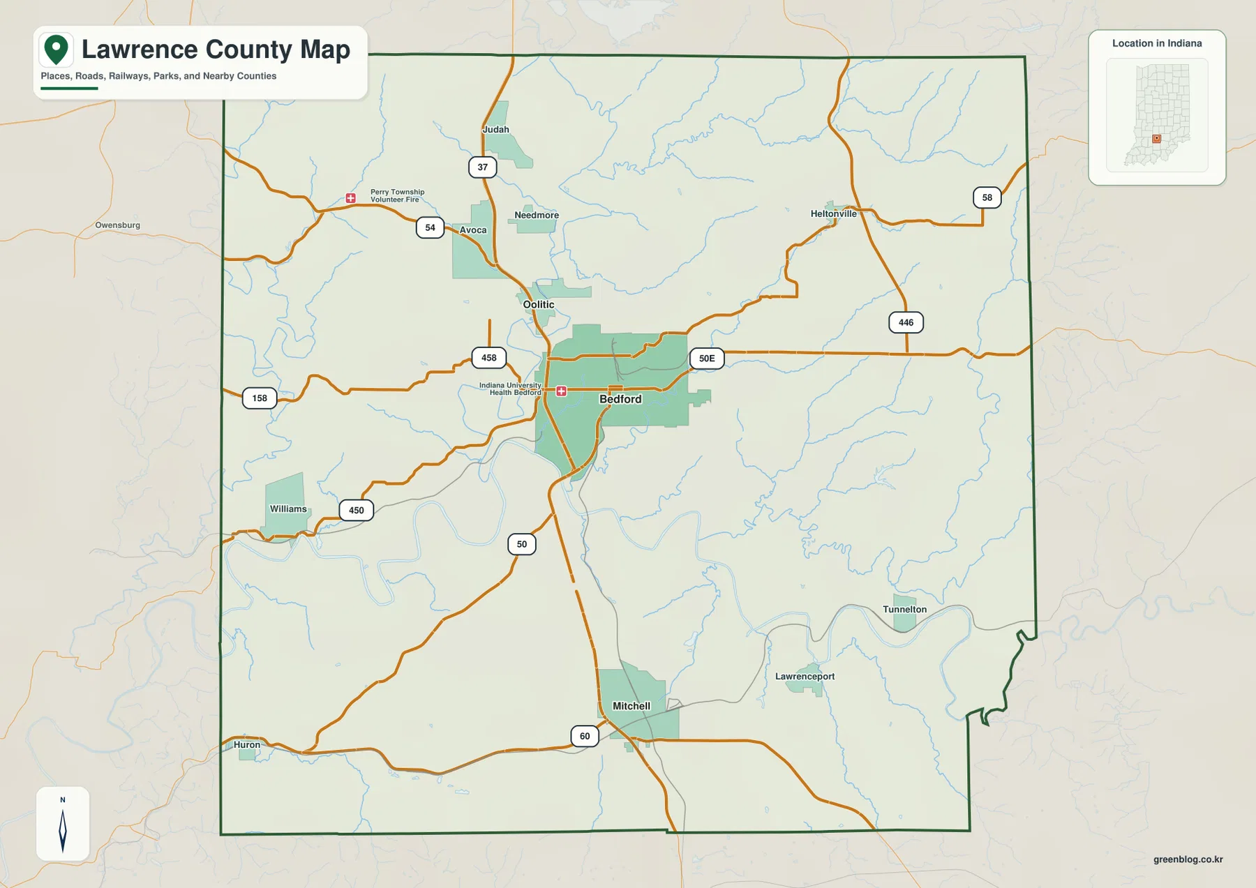
Williams provides a useful western reference near Route 450. Route 158 crosses the west-central area farther north, and the county boundary bends around several broad creek valleys rather than following only straight survey lines. When roads and town names disappear on the terrain views, that boundary shape helps keep the western side recognizable.
Heltonville anchors the northeast near Routes 58 and 446. Farther southeast, Tunnelton and Lawrenceport lie close to winding lowland corridors. This side of the county has fewer large developed areas, so the relationship between roads, creek valleys, and the irregular eastern boundary becomes more useful than any single town label.
The city-connections map compares Oolitic and Mitchell directly with Bedford
The supplied connector map uses Bedford as the hub and highlights Oolitic and Mitchell. The printed index values are 13,837 for Bedford, 3,937 for Mitchell, and 1,522 for Oolitic. Those figures belong to this map edition rather than a live demographic feed. The useful geographic message is simple: Oolitic sits very close to Bedford on the north side, while Mitchell lies farther south along the same broad Route 37 corridor.
| Map rank | Place | Value printed on map | Straight-line distance from Bedford | Direction |
|---|---|---|---|---|
| 1 | Bedford | 13,837 | Hub | Central |
| 2 | Mitchell | 3,937 | 8 mi | South |
| 3 | Oolitic | 1,522 | 3 mi | North |
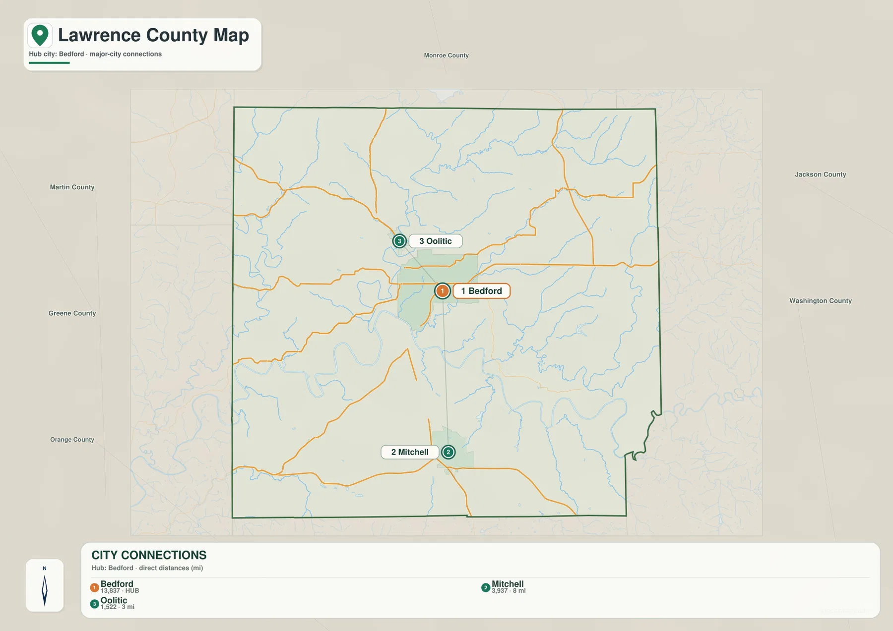
The 3- and 8-mile labels measure direct point-to-point distance, not the mileage of a driving route. Actual travel distance depends on the road selected and on the exact starting and ending locations. The general map is therefore the better companion when you want to see how Route 37 links the three communities rather than just how far apart their mapped centers are.
This connector graphic is deliberately limited to three highlighted places. It does not define municipal boundaries, commuting areas, traffic volumes, or the location of every settlement in Lawrence County. Williams, Heltonville, Avoca, Judah, Tunnelton, and other names remain available on the general map.
Leatherwood and Salt Creek valleys break the hill country into narrow low corridors
Leatherwood Creek is the strongest long water reference in the east-central part of the terrain-and-water map. It bends southwest through the interior, with South Fork Leatherwood Creek joining from the east. De Witt Creek and Back Creek cut additional valleys into the eastern uplands, while Guthrie Creek creates another long drainage line farther south. On the relief map, each of these channels occupies lower green terrain between higher ridges.
Little Salt Creek provides a northern reference, and Salt Creek occupies a separate west-central corridor. Indian Creek appears close to the western edge, while Beaver Creek is farther south. The map therefore does not revolve around one interior river; instead, multiple named creeks divide the county into a dense network of valleys and ridge blocks.
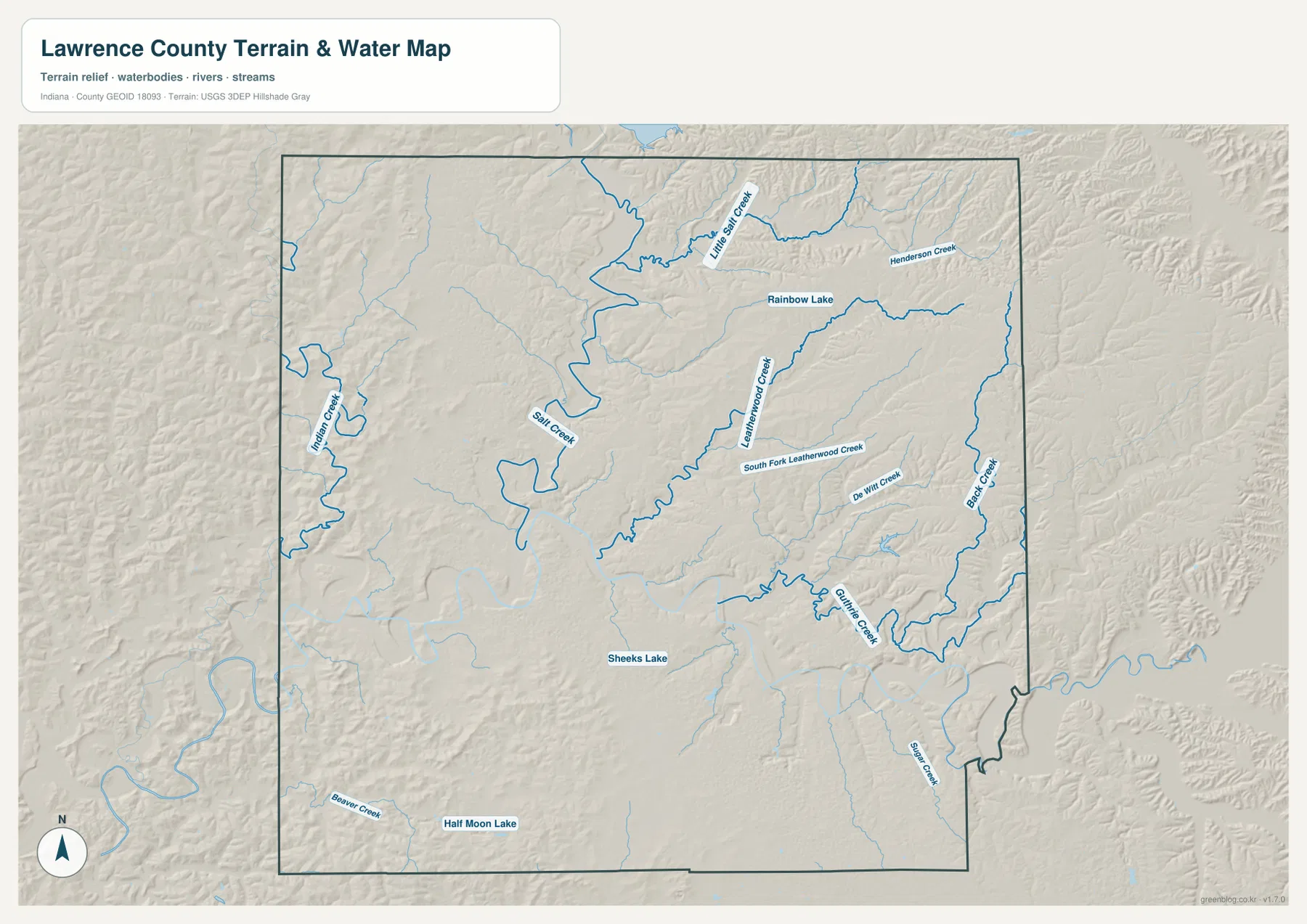
Rainbow Lake, Sheeks Lake, and Half Moon Lake provide small but useful water landmarks. Rainbow Lake lies in the northeastern interior, Sheeks Lake near the middle-south, and Half Moon Lake in the southwest. None is a county-scale reservoir, but each helps re-establish position once roads and settlement names have been removed from the terrain view.
Shaw Creek appears in the southeastern portion near the Mitchell–Lawrenceport side of the county. Nearby, Spring Mill State Park has an official State Road 60 address in Mitchell; Indiana DNR describes the park’s cave springs and the historic use of constant spring water to power early mills. The supplied county water map is a location-and-terrain reference, not a flood map, current water-level report, legal stream-boundary record, or property survey.
The 141–285 m surface contrasts creek lowlands with high western and eastern ridges
The elevation legend gives an actual Lawrence County range of about 141 to 285 meters and a mean of 201 meters. Green areas mark lower terrain, while yellow, tan, and brown indicate progressively higher ground. Broad creek valleys occupy much of the central and northern interior. The strongest ridge relief appears along the western side, across the northeast, and in the southwest.
Bedford lies near a transition between lower valley terrain and surrounding hills. North and west of the city, low corridors spread through the interior. To the east, Leatherwood Creek and its tributaries cut narrower green channels between higher ridges. The general road map may look relatively open across these rural areas, but the relief image shows how frequently the terrain rises and falls.
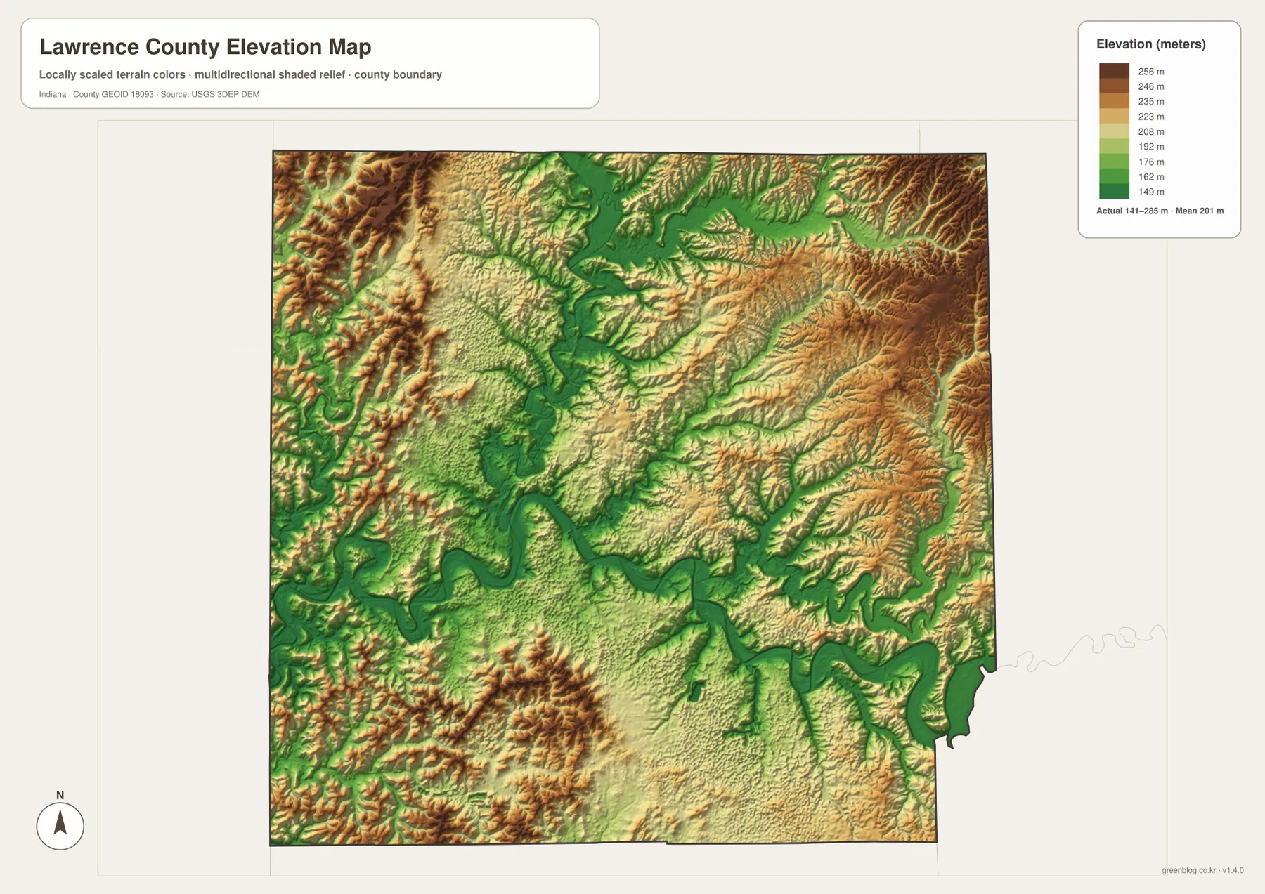
The northeastern hills are especially dissected. Little Salt Creek and Henderson Creek occupy lower channels, and the Back–Guthrie Creek side is cut by numerous tributary valleys. This is not one smooth upland surface; it is a sequence of ridges separated by narrow drainage corridors.
The southwest contains another strong hill group around the Williams–Mitchell side. Beaver Creek and smaller channels form lower cuts between the ridges. The south-central area becomes gentler, but the eastern boundary returns to deeply incised creek terrain. A useful county-scale picture is a lower central valley network surrounded by several separate belts of higher ground.
The 141–285 meter range summarizes generalized county relief. It is suitable for comparing valleys and ridges, but it is not a surveyed elevation for a parcel, foundation, road grade, or drainage design. Precise site work should use source elevation data such as the USGS 3D Elevation Program or measurements from a qualified survey.
Start with Bedford, then match the city distances to the creek valleys and surrounding ridges
For roads and settlements, begin with Bedford at the U.S. 50 and Route 37 corridor. Place Oolitic to the north, Mitchell to the south, Williams to the west, and Heltonville to the northeast. Smaller names such as Avoca, Judah, Tunnelton, and Lawrenceport are easiest to find on this detailed general view.
The connector map is the quickest way to compare Bedford with Oolitic and Mitchell. It shows straight-line distances of roughly 3 and 8 miles, respectively. Those direct measurements should not be substituted for driving mileage, which depends on the route and exact endpoints.
For physical geography, locate Leatherwood Creek and Little Salt Creek first and then add South Fork Leatherwood, Back, and Guthrie creeks. Switching to the elevation image at those same locations shows the stream corridors as low green cuts and the western, northeastern, and southwestern hills as higher terrain. The side-by-side comparison makes Lawrence County’s strongly dissected landscape much easier to understand.
The WebP images on the page are reduced previews. The Lawrence County archive contains four 3638×2572-pixel JPG originals covering the general road map, Bedford connector view, terrain-and-water map, and elevation map. The larger files are better for reading small road numbers, creek labels, and relief colors or for printing the maps.
A practical comparison is to keep Bedford fixed as the reference point. Find Oolitic and Mitchell on the general map, check their direct spacing on the connector map, move to the water view to trace Leatherwood and Salt Creek valleys, and finish on the relief map by comparing those low corridors with the surrounding ridge belts. That sequence links settlement, drainage, and terrain without requiring every small creek or road number to be memorized.
Frequently Asked Questions
How far are Oolitic and Mitchell from Bedford on the connector map?
The supplied graphic places Oolitic about 3 miles north of Bedford and Mitchell about 8 miles south. Both measurements are straight-line distances between mapped place points, so road-driving mileage and travel time will differ.
Which water features are easiest to recognize?
Leatherwood Creek and South Fork Leatherwood Creek are strong eastern references, Little Salt Creek lies to the north, and Salt Creek and Indian Creek help orient the west. Back Creek and Guthrie Creek divide the eastern hills, while Rainbow Lake, Sheeks Lake, and Half Moon Lake provide smaller water landmarks. The map shows geographic location rather than flood status or legal water boundaries.
Can the 141–285 m elevation range be used for exact site elevations?
No. The relief image gives a county-wide range with a mean of 201 meters and is intended for comparing creek valleys with the surrounding hills. For a Lawrence County parcel, building site, drainage plan, or road-grade question, use original elevation data or a qualified local survey rather than this county-scale relief image.
Map File Information
The Lawrence County ZIP combines the general road-and-place map, Bedford city-connections map, terrain-and-water map, and elevation map as full-resolution JPG originals.
- File Type: ZIP containing four 3638×2572px JPG files
Related Maps
Sources and References
The article is based primarily on the supplied Lawrence County map set and asset manifest. The following official sources provide county, Spring Mill, boundary, hydrography, and elevation context.
- Lawrence County, Indiana – official county government and Bedford county-seat information
- Indiana DNR – Spring Mill State Park – official information on the Mitchell-area park, cave springs, and natural setting
- U.S. Census Bureau TIGER/Line Shapefiles – county-boundary and geographic reference data
- USGS National Hydrography – creek and lake reference data
- USGS 3D Elevation Program – source terrain data for precise elevation work
Green Map creates custom-edited map images using open geographic data sources such as geoBoundaries, Natural Earth, OpenStreetMap, and government open data.
These maps are edited visual materials, not raw data files, and are provided for education, documents, presentations, and graphic reference.