LaPorte County reaches from Michigan City on the Lake Michigan shoreline through the inland city of La Porte and south into a much more rural landscape. Michigan City and La Porte are the two strongest urban references, while Westville, Trail Creek, Kingsford Heights, Wanatah, Rolling Prairie, Fish Lake, and La Crosse help organize the rest of the county. You can download the high-resolution JPG ZIP directly from this page for closer inspection of road shields, lake names, river labels, and relief shading. This LaPorte County Map page brings the settlement pattern together with the Pine–Clear Lake group, the Kankakee drainage, and a 177–289 meter terrain surface.
Michigan City is the obvious northwestern anchor because it sits immediately south of Lake Michigan. Trail Creek lies close to its eastern side. La Porte is a separate inland center farther southeast, surrounded by several lakes and connected to Westville, Rolling Prairie, Fish Lake, Kingsbury, and the southern towns by a broad road network. South of La Porte, the map becomes progressively less urban, with Wanatah and La Crosse providing widely spaced western references.
The relief map adds a strong topographic contrast. Its legend gives an actual range of about 177 to 289 meters and a mean of 223 meters. The Lake Michigan side and much of the far south are low and green. In between, a broad belt of high tan and brown ridges crosses the north-central interior and expands again toward the northeast. The Kankakee and Little Kankakee waterways occupy lower ground on the eastern and southeastern side of that upland belt.
Table of Contents
Michigan City and La Porte create two clear road-and-place anchors
Michigan City has the largest developed footprint on the general map and sits directly below Lake Michigan. U.S. 20 and the 35 corridor pass south and east of the city, while the 94 route crosses the northern county. Trail Creek is immediately to the east, and the map also labels Pottawattamie Park and LaPorte County Emergency Medical nearby. Using the shoreline and Michigan City together makes the northwest corner easy to recognize.
La Porte occupies a separate central location. Route 35 approaches from the north, Routes 2 and 100 cross the city area, and the 90/80 road pair lies farther west. Rolling Prairie is northeast of La Porte, while Fish Lake sits farther southeast. The city’s surrounding lakes are already visible on the general map and become the most useful landmarks when switching to the terrain-and-water view.
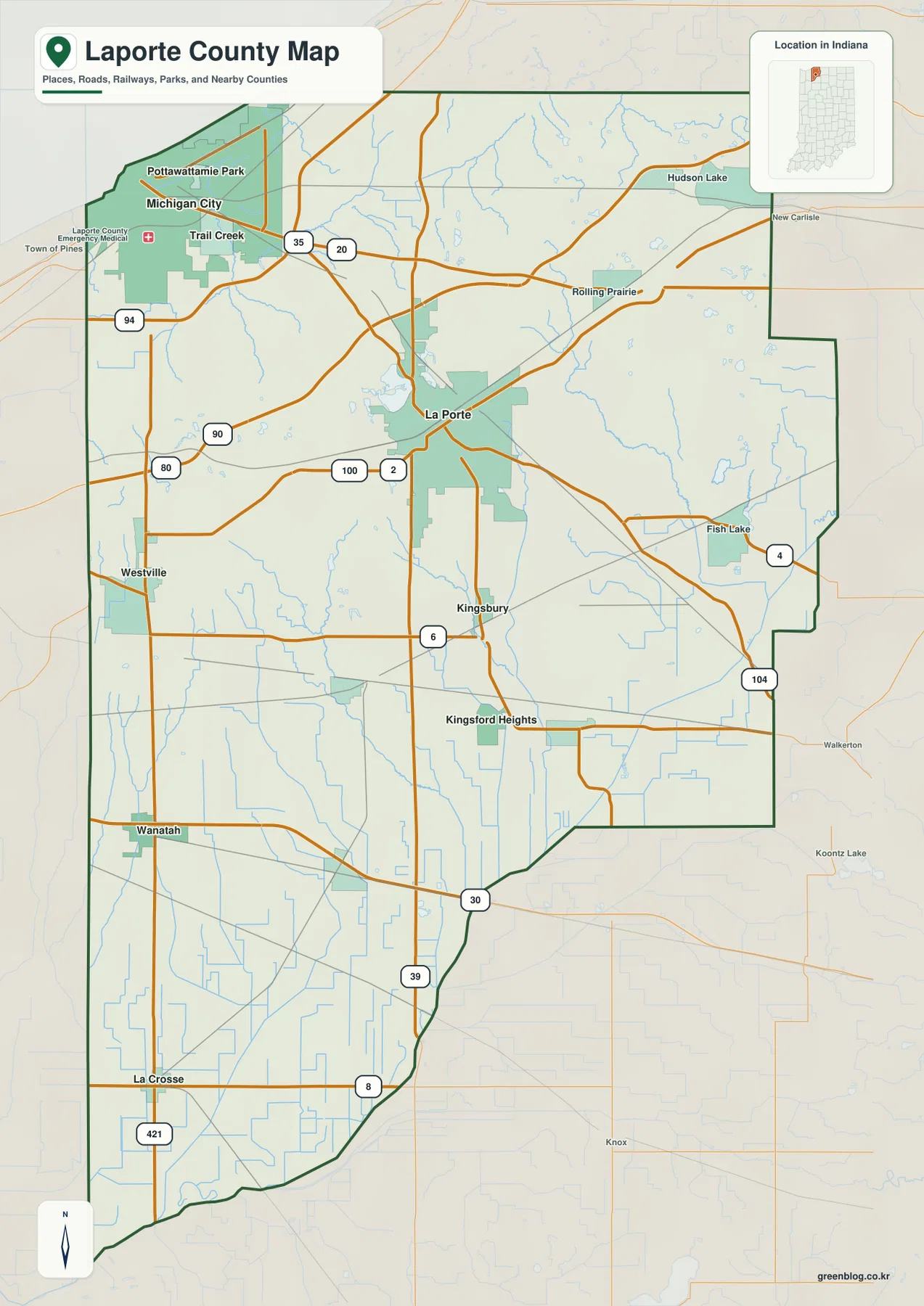
Westville sits west of La Porte, and Wanatah is farther south near the western boundary. La Crosse provides the final major settlement reference near the southwest. The 421 corridor passes the La Crosse side, and Routes 39 and 8 help locate the southern interior. Compared with the Michigan City–La Porte half, the lower county contains much larger gaps between developed areas.
Rolling Prairie and Fish Lake are the most useful named references in the east. Rolling Prairie lies on the northeast road corridor, while Fish Lake is farther south near Routes 4 and 104. Kingsbury and Kingsford Heights occupy the middle-south between La Porte and the lower boundary. These locations become especially helpful on the water map, where Kingsbury Creek and the Fish Lake system replace many of the road labels.
The six-place city index separates a large shoreline city from a second inland center
The supplied city index highlights six places. Michigan City is printed at 31,814 and La Porte at 22,449. Westville follows at 5,279, Trail Creek at 2,351, Kingsford Heights at 1,358, and Wanatah at 1,178. These are values printed on the supplied map edition, not a live demographic feed. Their main value here is spatial: the two large centers are separated, while the four smaller entries spread through the west, center, and southwest.
| Rank | Place | Value printed on map | Position |
|---|---|---|---|
| 1 | Michigan City | 31,814 | Northwest / Lake Michigan side |
| 2 | La Porte | 22,449 | Central |
| 3 | Westville | 5,279 | West-central |
| 4 | Trail Creek | 2,351 | East of Michigan City |
| 5 | Kingsford Heights | 1,358 | South-central |
| 6 | Wanatah | 1,178 | Southwest |
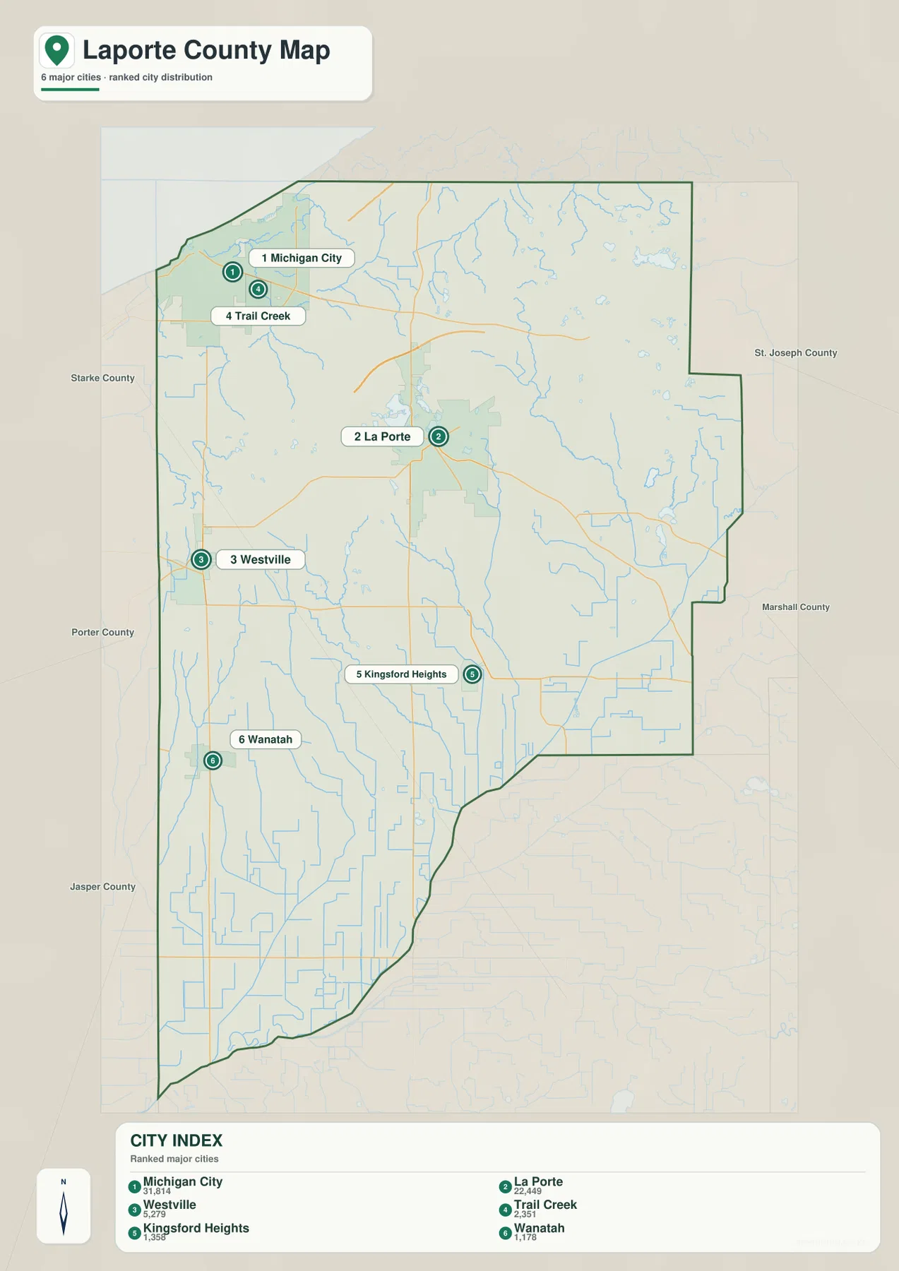
Michigan City and Trail Creek are close together in the northwest, but they remain separate highlighted places. La Porte is much farther inland and forms its own central cluster. Westville lies to its west, Kingsford Heights to the south, and Wanatah still farther southwest. That arrangement makes the city index a quick way to see that LaPorte County does not revolve around a single urban center.
The detailed general map includes additional names such as Rolling Prairie, Fish Lake, Kingsbury, and La Crosse. Those places disappear from the simplified index, so the two views answer different questions. Use the road map for detailed location and the index for a clean comparison of the six highlighted centers. For current population counts, use an up-to-date official statistical source rather than the printed map values.
Pine and Clear lakes surround La Porte while Kankakee waterways define the east
The terrain-and-water map makes the La Porte lake group immediately recognizable. Pine Lake and Clear Lake sit close together, with Fishtrap Lake just to the north. The City of La Porte’s official site highlights Pine Lake and Clear Lake as part of the community’s lake-oriented outdoor setting, which matches their prominent position around the central city on the supplied map.
Farther northeast, Galena River winds through the upper interior, and Saugany Lake and Hudson Lake provide separate water landmarks. Little Kankakee River becomes the strongest eastern channel and continues toward the Upper Fish Lake and Lower Fish Lake area. The larger Kankakee River appears farther south along the southeastern side. Following those features from north to south makes the eastern half much easier to understand.
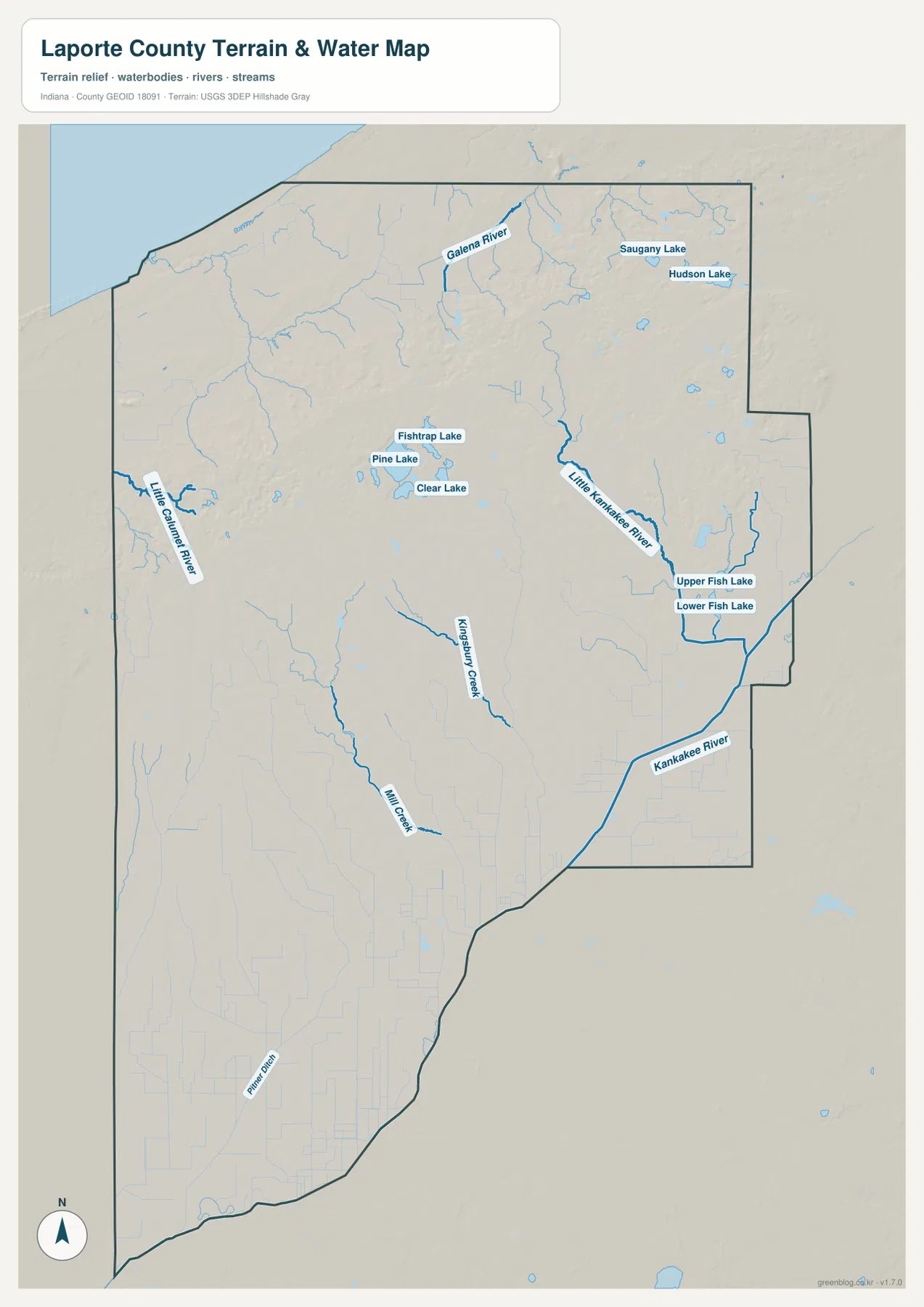
Little Calumet River appears on the western side, while Kingsbury Creek runs through the south-central interior. Mill Creek and Pine Ditch provide additional lower-county drainage lines. Indiana DNR’s Kingsbury Fish & Wildlife Area information describes a landscape of marshes, drainage ditches, a lake, and Kankakee River access in the Kingsbury area, giving useful real-world context for the water-rich southern interior shown on the map.
The blue lines and water polygons on this page are geographic references, not legal or hazard determinations. They do not establish a floodplain, current water level, water-quality condition, navigation right, or parcel boundary. Those questions require the current source maintained by USGS, FEMA, Indiana DNR, or the relevant local agency.
The 177–289 m elevation surface rises sharply into the north-central and northeastern ridges
The elevation legend gives an actual LaPorte County range of about 177 to 289 meters and a mean of 223 meters. The Lake Michigan side is broadly low and green, and the far south is also dominated by lower terrain. Between those areas, a large belt of tan and brown high ground crosses the north-central interior and expands toward the northeast.
La Porte sits near an important transition. Pine Lake, Clear Lake, and the city occupy lower basins, while substantially higher ridge terrain rises just north and northwest. The contrast is easy to miss on the road map but becomes obvious on the relief image. This explains why the central lake group and the surrounding uplands look so different even though they are close together.
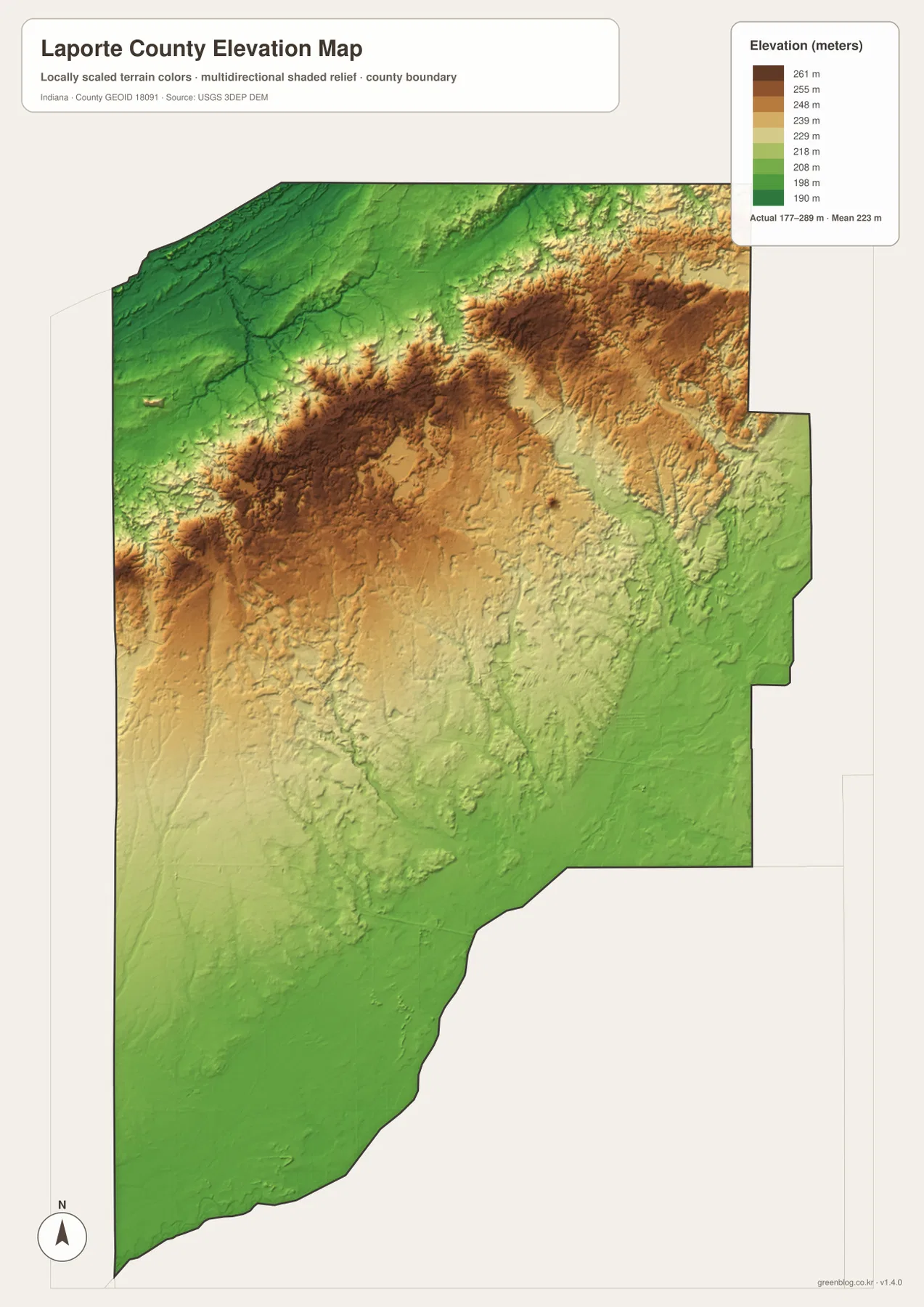
The northeast stays high overall but is cut by lower channels and lake basins. Galena River and Hudson Lake occupy lower ground within the uplands, and Little Kankakee River forms a greener corridor farther southeast. The eastern side therefore alternates between high ridges and stream-cut low areas rather than forming one continuous plateau.
The southern half is much gentler. From Wanatah and La Crosse toward the lower boundary, green terrain covers broad areas, with Kingsbury Creek, Mill Creek, and Pine Ditch adding narrow drainage lows. A useful county-scale picture is a low Lake Michigan edge, a high north-central/northeastern belt, and a lower southern plain.
The 177–289 meter values describe generalized county relief, not survey-grade site elevation. A parcel corner, building pad, road grade, or drainage project needs original elevation data such as the USGS 3D Elevation Program or measurements from a qualified survey. The map is best used to compare the shoreline lowland, central lake basins, high ridges, and southern flats.
Begin with Michigan City and La Porte, then follow the lakes and Kankakee system into the relief map
For roads and settlements, start at Michigan City below Lake Michigan and then find La Porte in the center. Westville, Rolling Prairie, Fish Lake, Wanatah, and La Crosse provide the next layer of orientation. The southern road network is less urban, so the county outline and stream lines become increasingly useful as place labels thin out.
The city index gives a clean comparison of the two large centers and four smaller highlighted places. Michigan City leads the printed values, La Porte follows, and Westville, Trail Creek, Kingsford Heights, and Wanatah supply western and southern references. Use a current official demographic source if current population totals are required.
For physical geography, locate the Pine–Clear Lake cluster around La Porte first, then trace Galena River in the northeast and the Little Kankakee and Kankakee rivers down the east. Switch to the elevation surface at those same locations and the relationship becomes clear: lake and river basins sit below the north-central ridge belt, while the southern county returns to much lower ground.
The WebP images on this page are reduced previews. The ZIP below contains four original 2572×3638-pixel JPG files—the general county map, city index, terrain-and-water map, and elevation map. The larger files are the better choice for printing or reading small road, lake, and stream labels.
A useful comparison is to keep La Porte fixed as the central reference. Find Michigan City and La Porte on the general map, compare their scale on the city index, move to the water view to identify Pine Lake, Clear Lake, and the Kankakee drainage, and finish on the elevation image by comparing the lake basins with the higher ridge belt. The same method works from Fish Lake or Rolling Prairie if the eastern half is your main interest.
Frequently Asked Questions
Which places have the largest values on the supplied city index?
Michigan City is printed at 31,814 and La Porte at 22,449. Westville follows at 5,279, Trail Creek at 2,351, Kingsford Heights at 1,358, and Wanatah at 1,178. These values belong to the supplied map edition rather than a live statistical feed.
Which water features are easiest to recognize?
Pine Lake, Clear Lake, and Fishtrap Lake form a distinctive group around La Porte. Galena River and Hudson Lake help orient the northeast, while Little Kankakee River, Upper Fish Lake, Lower Fish Lake, and Kankakee River define the eastern and southeastern drainage. The map shows geographic position, not flood status or legal water boundaries.
Can the 177–289 m elevation range be used for exact site elevations?
No. The elevation image gives a county-wide range with a mean of 223 meters and is intended for comparing shoreline lowlands, lake basins, high ridges, and southern flats. Parcel, construction, drainage, or engineering work requires original elevation data or professional survey measurements.
Map File Information
The LaPorte County ZIP combines the road-and-place map, six-place city index, terrain-and-water map, and elevation map as full-resolution JPG originals.
- File Type: ZIP containing four 2572×3638px JPG files
Related Maps
Sources and References
The article is based primarily on the supplied LaPorte County map set and asset manifest. The following official sources provide county, city-lake, Kingsbury natural-area, boundary, hydrography, and elevation context.
- La Porte County Government – official county government information
- City of La Porte – official city information including local lake recreation
- Indiana DNR – Kingsbury Fish & Wildlife Area – official information on the Kingsbury landscape and Kankakee River access
- U.S. Census Bureau TIGER/Line Shapefiles – county-boundary and geographic reference data
- USGS National Hydrography – river, creek, and lake reference data
- USGS 3D Elevation Program – source terrain data for precise elevation work
Green Map creates custom-edited map images using open geographic data sources such as geoBoundaries, Natural Earth, OpenStreetMap, and government open data.
These maps are edited visual materials, not raw data files, and are provided for education, documents, presentations, and graphic reference.