Butte County Idaho Map files are available as a ZIP of high-resolution A3 JPG maps, with WEBP previews on the page for fast browsing. The four views make it easy to locate Arco, Moore, and Butte City, follow US 20, US 26, and US 93, trace the Big Lost and Little Lost river systems, and compare the broad lower plain with the much higher northern ranges.
Arco is the easiest place to use as a reference point. From there, the county stretches north into long mountain valleys, east across open lower country, and southwest through a narrower arm of rugged terrain. The maps make that irregular shape easier to understand because roads, towns, rivers, and elevation all point to the same contrast between valley corridors and high ranges.
Table of Contents
Arco anchors the middle of an unusually shaped county
Idaho’s official county information identifies Arco as the county seat, and the general map shows why it works well as the main orientation point. Arco sits near the junction of several numbered highways and close to the Big Lost River. Moore lies north in the same broad corridor, while Butte City is only a short distance to the east on the lower plain.
The boundary is far from rectangular. A tall northern section, a broad eastern block, and a tapering southwestern arm give Butte County a stepped outline. Instead of trying to memorize that shape, it is easier to divide the county into the Arco plain, the northern valleys, the eastern open country, and the southwestern mountain arm.
Three highlighted communities sit close to the lower central corridor
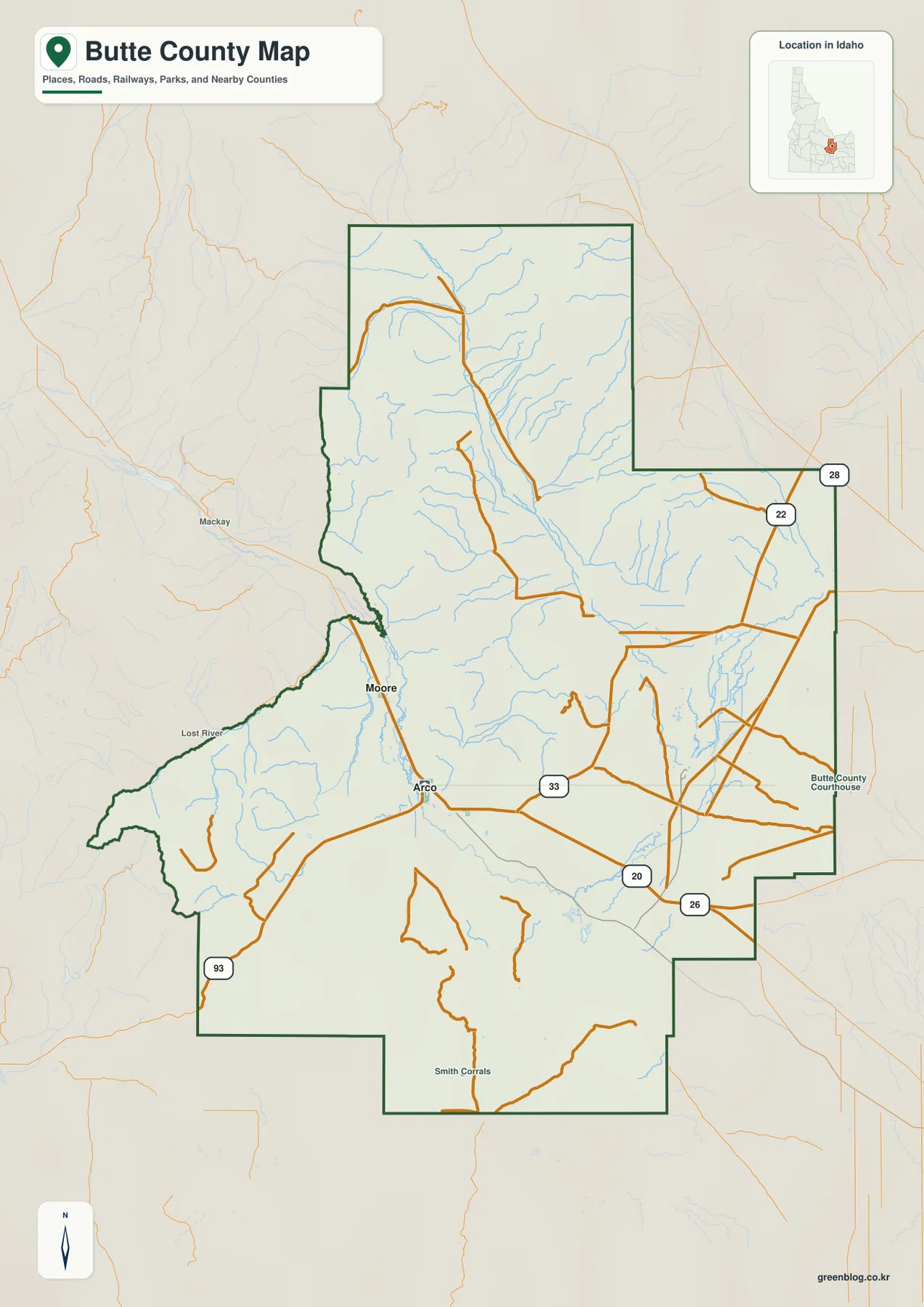
The city-connections map highlights Arco, Moore, and Butte City. Arco is used as the hub. Moore is shown about eight miles away and Butte City about four miles away. Those figures are straight-line distances on the city map, not driving distances along the road network.
The simplified city view makes the settlement pattern obvious. The marked communities are concentrated in lower terrain rather than scattered across the highest ranges. Moore continues north from Arco along the Little Lost River side of the county, while Butte City sits east of Arco on flatter ground. This view is especially useful when the dense stream network on the other maps makes place names harder to spot.
Highways converge around Arco before spreading across the plain
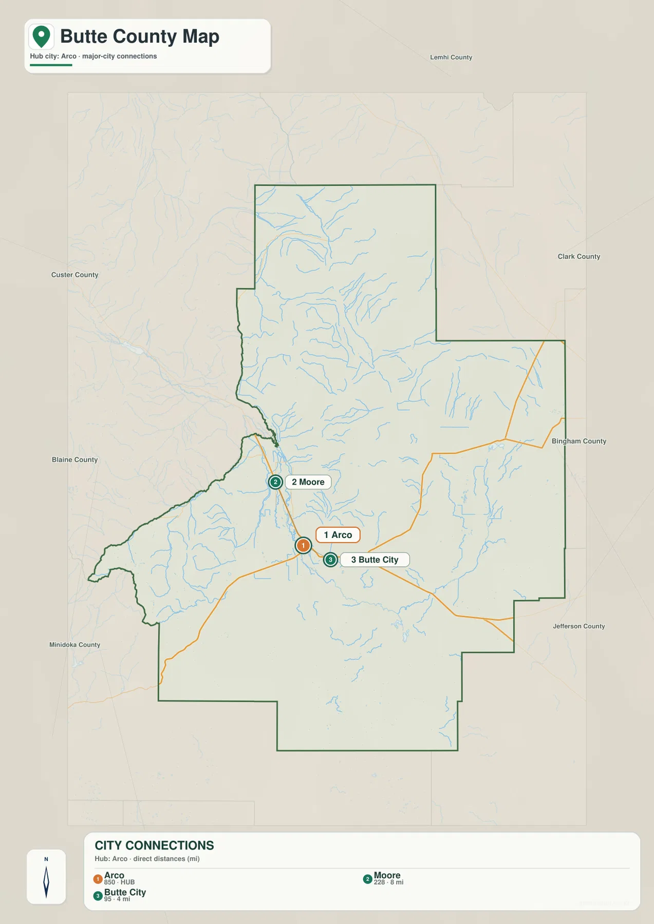
US 20 and US 26 pass through the Arco area and form the strongest east-west route shown on the map. US 93 approaches from the southwest and also ties into the central corridor. State routes 22, 28, and 33 appear farther east and northeast, giving the lower half of the county a much more visible road network than the rugged northern mountains.
That pattern matches the relief. The highways stay on broad low ground or follow valley passages, while the higher northern ridges have fewer prominent through routes. Comparing the overview with the elevation map helps explain why the roads bend around mountain blocks instead of crossing them in straight lines.
Big Lost River and Little Lost River define separate valley systems
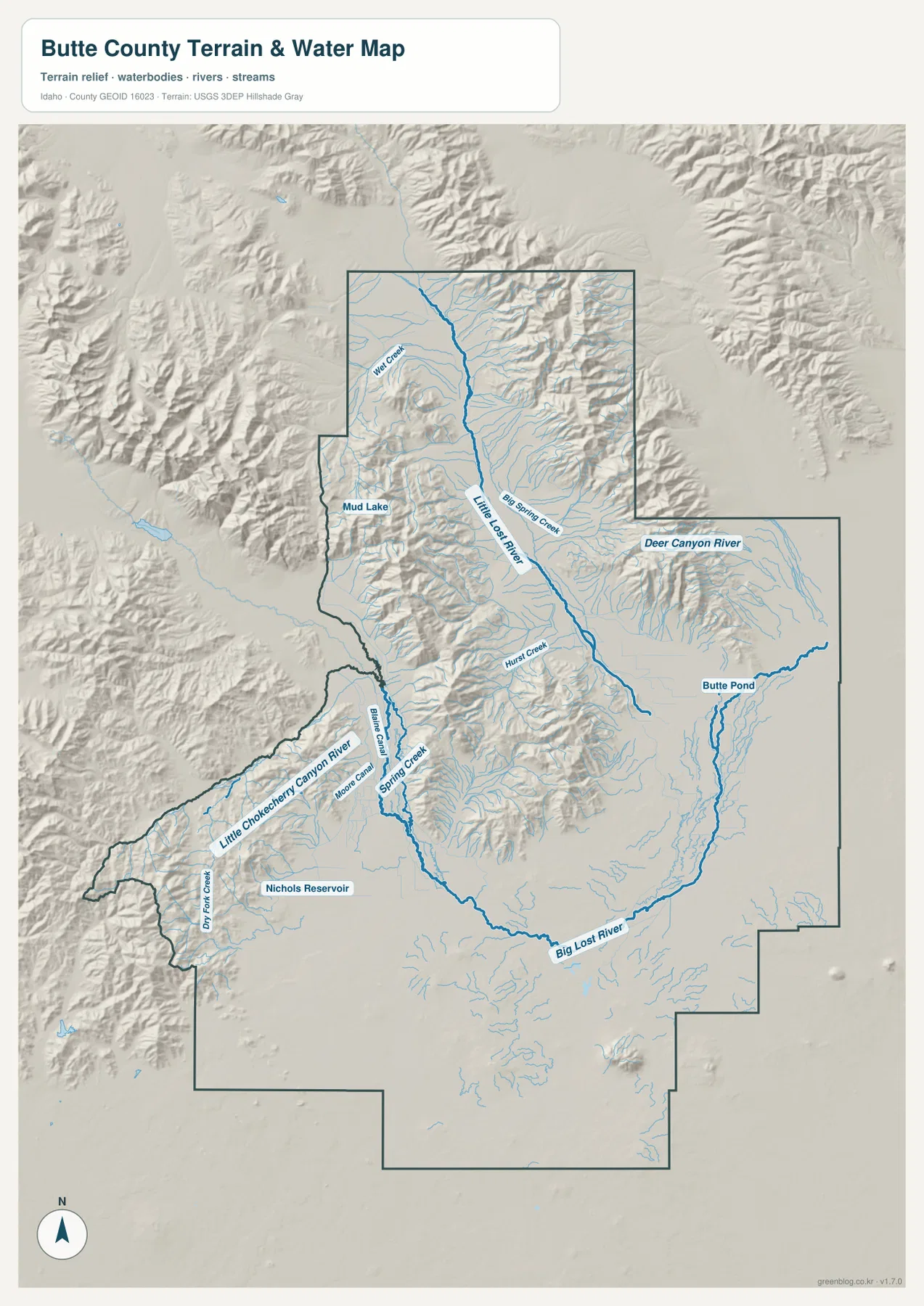
The terrain-and-water map is dominated by the Big Lost River and Little Lost River. The Little Lost River runs down the long northern valley, while the Big Lost River passes the Arco area and bends across the lower central part of the county. Their separate courses make them useful reference lines for understanding the county’s mountain-and-basin geography.
Big Spring Creek, Deer Canyon River, Hunt Creek, Spring Creek, and many smaller tributaries are also labeled. Nichols Reservoir appears in the southwest, Mud Lake is marked near the northwestern side, and Butte Pond provides another recognizable water feature in the east. The branching creeks are much denser where the shaded relief becomes steeper.
This is a geographic water-reference map rather than a flood, parcel, legal-boundary, depth, or navigation map. Its main value is showing where rivers, reservoirs, and mountain streams sit in relation to the county’s terrain.
Elevation climbs sharply from the southern plain into the northern ranges
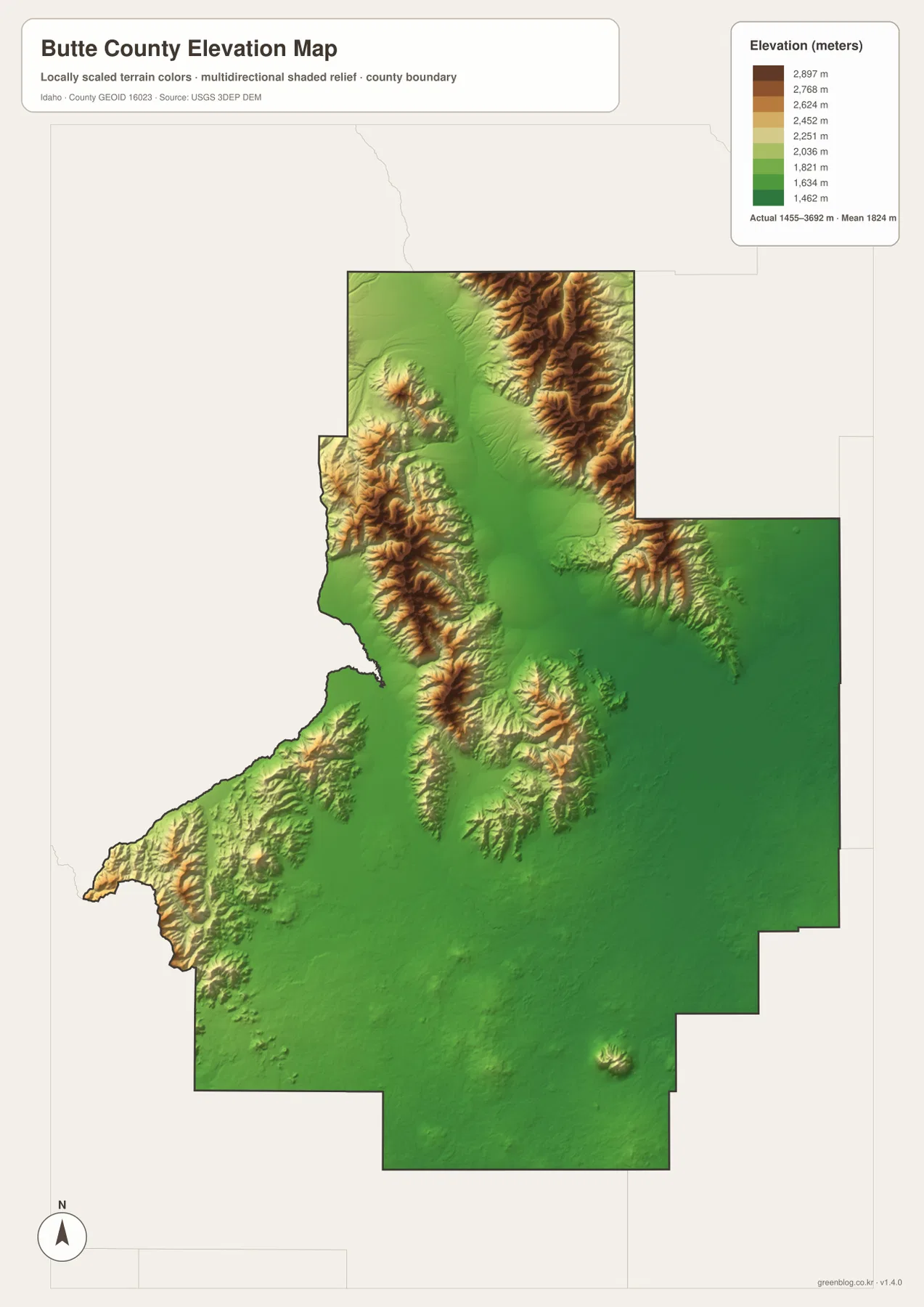
The elevation map gives Butte County one of its clearest visual contrasts. Much of the southern and eastern county is shown in green, indicating broad lower terrain. North and northwest of Arco, the colors shift rapidly through yellow and tan into dark brown along the high mountain belts. The Little Lost River valley remains a lower strip between those ridges.
The map reports an actual elevation range of about 1,455 to 3,692 meters and a mean near 1,824 meters. Those values are useful for county-scale comparison, especially when deciding whether a location lies on the lower plain or within the mountain belts. The generalized surface should not be treated as survey-grade or engineering-grade elevation for a specific site.
Choose the map that matches the question you are trying to answer
For basic orientation, the county overview is the best starting point because it combines towns, roads, rivers, and nearby areas. The city map is cleaner when the goal is simply to compare Arco, Moore, and Butte City. The terrain-and-water view is more useful for following river corridors and tributaries, while the elevation map quickly separates the broad lower plain from the high ranges.
Using the maps together adds context. You can find Arco on the city view, check its highway connections on the overview, follow the Big Lost River on the water map, and then compare the surrounding terrain on the elevation map. That sequence works well for classroom assignments, local reports, presentations, and county-to-county comparisons.
Frequently Asked Questions
What is the main town in Butte County?
Arco is the county seat and the strongest map reference point. Moore lies north of Arco and Butte City is a short distance to the east, so those three communities form the main highlighted settlement group on the city map.
Are the Big Lost River and Little Lost River the same waterway?
No. They occupy different valley systems. The Little Lost River runs down the long northern valley, while the Big Lost River crosses the Arco area and the lower central part of the county.
Where is the highest terrain shown on the elevation map?
The highest colors are concentrated in the northern and northwestern mountain belts. The southern and eastern plain is much lower, and the map lists an overall actual elevation range of about 1,455 to 3,692 meters.
Map File Information
The ZIP contains high-resolution A3 JPG versions of the Butte County overview, city, terrain-and-water, and elevation maps.
- File Type: JPG files inside one ZIP archive
Related Maps
Sources and references
- Butte County Idaho official website
- Butte County Idaho — Communities
- U.S. Census Bureau TIGER/Line Shapefiles
- USGS National Hydrography
- USGS 3D Elevation Program
Green Map creates custom-edited map images using open geographic data sources such as geoBoundaries, Natural Earth, OpenStreetMap, and government open data.
These maps are edited visual materials, not raw data files, and are provided for education, documents, presentations, and graphic reference.