Oldham County Texas map|Vega, Route 66 towns, and Canadian River ranch country

Oldham County is crossed by one of the best-known highway corridors in the United States, yet most of its land lies far beyond the service stations and Route 66 landmarks seen from Interstate 40. The Oldham County Texas map places Vega and Adrian along the southern travel corridor, then reaches north to Boys Ranch, historic Tascosa, and the broken terrain of the Canadian River. The county had an estimated 1,823 residents in 2024 across 1,500.52 square miles of land.

This is a ranch-centered county with two contrasting geographic zones. The south follows the level Llano Estacado and the Amarillo–New Mexico route, while the north is cut by the Canadian River valley and associated breaks. The map set preserves that separation so communities are not made to appear closer than they are.

Continent: North America
Country: United States
State: Texas
County: Oldham County
Location in State: Western Texas Panhandle east of the New Mexico line
Adjacent Regions: Hartley County, Moore County, Potter County, Deaf Smith County, Quay County
Major Places: Vega, Adrian, Boys Ranch, Wildorado, Tascosa
Geographic Features: Canadian River, Canadian River Breaks, Llano Estacado

What the map covers from the state line to Amarillo

The county touches Quay County, New Mexico, on the west and extends east toward Potter County and the Amarillo area. Interstate 40 enters near Adrian, passes Vega, and continues toward Wildorado. Hartley County lies to the north, Deaf Smith County to the south, and Moore County touches the northeastern side.

Vega is the county seat and the main government and service point. Adrian is smaller but has a national road-trip identity because it is promoted as the midpoint of historic Route 66 between Chicago and Los Angeles. Wildorado sits near the eastern approach to Amarillo and extends into the neighboring county setting.

Route 66 travel occupies only one band of the county

The old highway and modern interstate brought restaurants, fuel stops, motels, and freight traffic to the southern corridor. Vega preserves historic roadside buildings and continues to serve local residents and long-distance travelers. Adrian’s midpoint identity gives it a tourism role that is unusual for a place with a very small permanent population.

Leaving I-40 changes the scale of travel quickly. County and ranch roads lead across large parcels where livestock operations, grain fields, and energy infrastructure are more common than compact settlements. U.S. 385 at Vega is one of the principal routes for reaching places north or south of the interstate.

Tascosa records an earlier ranching network

Before the railroad towns and paved highways became dominant, Tascosa served as an important trading and supply place in the Canadian River country. Large Panhandle ranches used the river valley for water, grass, crossings, and access between distant grazing areas. When new rail centers captured commerce, Tascosa declined and became a historic site rather than a modern service town.

Boys Ranch occupies another part of the northern county and represents a living community within the broad ranch landscape. Its location near the Canadian River is geographically separate from the Vega–Adrian corridor, a distinction that is easy to miss on road maps focused only on I-40.

Population growth does not reduce the rural scale

The estimated population increased from 1,763 in 2020 to 1,823 in 2024, a gain of 3.4 percent. Even after that increase, the density remains close to 1.2 residents per square mile. Most public services and permanent addresses are concentrated in a few communities, leaving extensive areas devoted to ranching and agriculture.

Surface water accounts for only about 0.06 percent of the county’s official area. The Canadian River is nevertheless a major landscape feature because its valley interrupts the level plains and helped determine historic ranch locations, routes, and settlement patterns.

Color Map

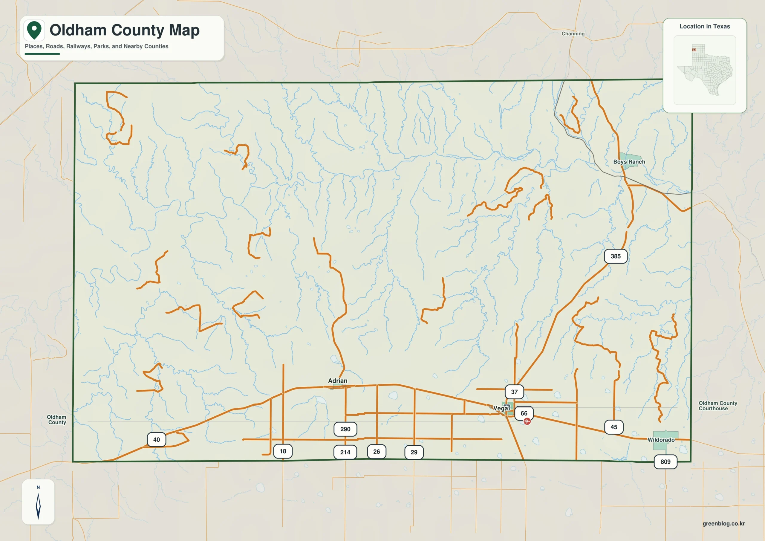
The Oldham County Texas map color edition separates the county from Quay County in New Mexico and from Hartley, Moore, Potter, and Deaf Smith counties in Texas. Vega and Adrian identify the southern I-40 band, while Boys Ranch and Tascosa draw attention to the much more remote northern half. The Canadian River provides the key geographic break between those settlement groups. Wildorado near the east side helps orient the county toward Amarillo, while the western border shows the approach from Tucumcari and New Mexico.

Color map of Oldham County with Vega, Adrian, Boys Ranch, Tascosa, and neighboring counties
Color-separated view of the southern highway towns and northern Canadian River breaks

Black-and-White Map

The monochrome edition retains community names and boundary lines without relying on colored areas. Vega remains easy to locate at the I-40 and U.S. 385 connection, and Adrian can be compared with the western state line. The clean background also leaves room to trace Route 66 or add a northbound route toward Boys Ranch and Tascosa.

Black-and-white Oldham County map with selected communities and county boundaries
Monochrome county reference for travel, ranch history, and print layouts

Outline Map

The outline file removes printed place names and fills, leaving the county perimeter and included internal linework. Users can label Vega, Adrian, Wildorado, Boys Ranch, and Tascosa, then draw the Canadian River or the I-40 corridor. The surrounding counties and New Mexico boundary can be added to create a custom western Panhandle study map.

Blank outline map of Oldham County and included boundary lines
Unlabeled base for adding highways, river valleys, historic places, and adjacent counties

Download the printable county maps

The A3 JPG package contains color, black-and-white, and outline editions. The labeled files support travel, county, and historical reference, while the blank version is suitable for highway diagrams, ranch-history lessons, and custom annotations.

County Map File Information

The download includes three Oldham County map styles. Selected place names appear on the color and monochrome editions, while the outline edition retains boundary linework without labels or area fills.

  • Included Versions: Color, Black and White, Outline
  • File Type: JPG
  • Printable Size: A3
  • Map Coverage: County perimeter, included internal boundaries, neighboring county and state context
  • Suggested Uses: Printing, Route 66 planning, reports, lessons, and custom labels
Download Oldham County Map Files

Frequently Asked Questions

Which town is the Oldham County seat?

Vega is the county seat and the location of the courthouse and primary county offices.

Why is Adrian associated with Route 66?

Adrian is identified as the midpoint of the historic highway between Chicago and Los Angeles, giving the small community a prominent road-trip identity.

Are Boys Ranch and Tascosa near Interstate 40?

No. They are in the northern Canadian River country and are geographically separated from the Vega–Adrian interstate corridor.

Official and historical references

Green Map creates custom-edited map images using open geographic data sources such as geoBoundaries, Natural Earth, OpenStreetMap, and government open data.

These maps are edited visual materials, not raw data files, and are provided for education, documents, presentations, and graphic reference.
Leave a Comment

Your email address will not be published. Required fields are marked *

Scroll to Top