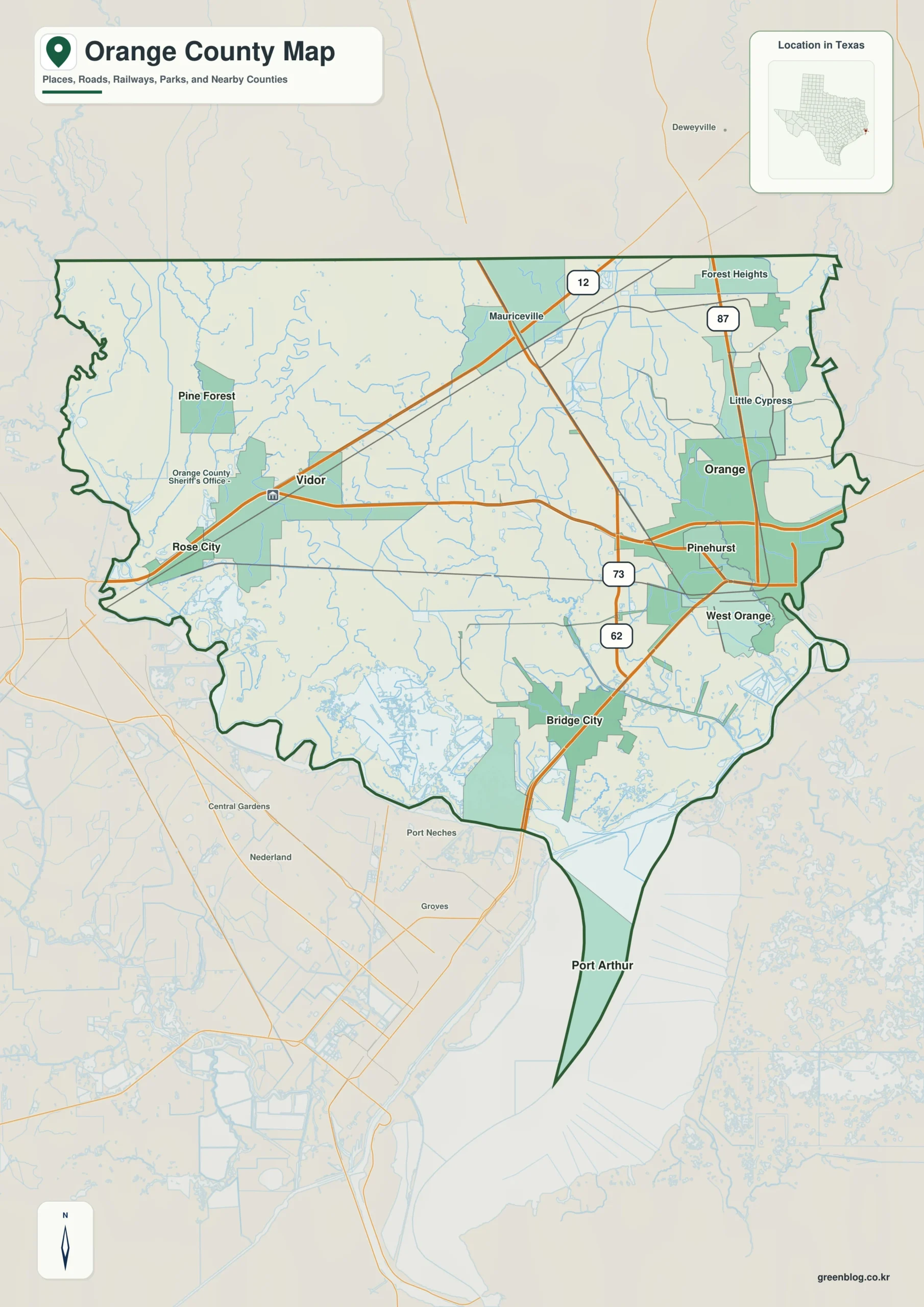
You can download four high-resolution A3 JPG maps of Orange County, Texas, in one ZIP directly from this page. The package includes a general county map, a ranked city map, a terrain-and-water map, and an elevation map. The supplied maps show Orange, Vidor, Bridge City, West Orange, Pinehurst, Pine Forest, numbered roads including 12, 87, 73, and 62, plus Cow Bayou, Adams Bayou, Little Cypress Bayou, several creeks and canals, and an actual elevation range of about -6 to 31 meters.
The county is easiest to understand by separating the eastern Orange urban cluster from Vidor in the west and the very low, water-rich southern end near Bridge City. Orange, Pinehurst, and West Orange sit close together. Vidor and Pine Forest form a separate western group, while Bridge City lies farther south where bayous, canals, and broad wet lowlands become more prominent. The elevation map reinforces that pattern: the north and upper interior are slightly higher, but the southern and bayou corridors fall to only a few meters above sea level, with some locally scaled values below zero.
Table of Contents
Orange and Vidor provide the two clearest mainland orientation points
Orange is the strongest settlement label on the general county map. Pinehurst and West Orange lie close to its southwestern side, and Little Cypress appears just to the north. Forest Heights provides another northern reference. This tight eastern grouping contrasts with the broader open interior to the west.
Vidor sits in the west-central part of the county. Rose City lies southwest of it, while Pine Forest is farther northwest. A major east-west road corridor connects the Vidor side with the Orange side, making those two cities the simplest first pair to locate. Mauriceville, north of the central corridor, helps establish the upper half of the county before the map reaches the less developed northern boundary.
Among the clearly labeled numbered roads, Route 12 provides a northeastern reference, Route 87 follows the Orange side north to south, and roads 73 and 62 help locate the area southwest of Orange and toward Bridge City. South of the main urban cluster, road labels become less dominant as drainage channels and broad low areas occupy more of the map.

The ranked city layer shows a compact eastern cluster and a separated western pair
The city map ranks six major communities. Orange is number 1, Vidor number 2, Bridge City number 3, West Orange number 4, Pinehurst number 5, and Pine Forest number 6. The CITY INDEX prints 19,177 for Orange, 9,708 for Vidor, 9,640 for Bridge City, 3,420 for West Orange, 1,999 for Pinehurst, and 519 for Pine Forest.
No year is shown for those index values, so this article treats them only as figures printed on the supplied map rather than confirmed current population counts. Their locations are more useful. Orange, Pinehurst, and West Orange are closely grouped in the east, Vidor and Pine Forest are separated to the west, and Bridge City lies farther south in a much more water-dominated setting.
Jefferson County is labeled to the west, Newton County to the northwest, Hardin County to the southwest, and Jasper County farther north. These surrounding names help place the irregular county outline. The eastern boundary is much less straight than the western side, reflecting the network of river and bayou channels that also appears on the terrain-and-water layer.

Cow Bayou forms the main central drainage reference
Cow Bayou is one of the easiest water features to follow across the middle of the terrain-and-water map. It runs generally southward through the central interior and receives numerous smaller branches. On the western side, Tenmile Creek, Tiger Creek, and Caney Creek occupy neighboring drainage corridors, giving the Vidor-side landscape far more water detail than the general road map first suggests.
East of Cow Bayou, Cole Creek and Sandy Creek run through separate low corridors. They approach the Adams Bayou system farther east and divide the central part of the county into a series of narrow drainage areas. The map therefore shows Orange County as a closely connected web of bayous and creeks rather than a flat surface crossed only by roads.
Adams Bayou and Little Cypress Bayou organize the eastern lowlands
Adams Bayou runs through the east-central interior, while Little Cypress Bayou occupies a separate corridor farther northeast. These two waterways are useful for understanding the land around Orange and Little Cypress. Numerous smaller branches feed into them, creating a complex pattern between the urban area and the irregular eastern boundary.
Farther south, Coon Bayou and Old River Bayou appear within a much broader network of channels. Sabine River Authority Canal is also labeled across the lower part of the county. This southern section is visibly different from the narrower northern creeks because large water surfaces, canals, and low branching channels occupy a much greater share of the mapped area.
The terrain-and-water layer is intended for geographic reference. It can help match Cow Bayou, Adams Bayou, Little Cypress Bayou, Cole Creek, Sandy Creek, and the lower canal system to Orange, Vidor, and Bridge City, but it should not be treated as a legal water-boundary, navigation, parcel, or flood-hazard product. For road access, locate the water feature first and then compare the same place with the general county map.

Small elevation changes matter across a county averaging only four meters
The elevation map reports an actual range of about -6 to 31 meters and a mean elevation of about 4 meters. Orange County is therefore very low overall, but the map still shows a clear internal pattern. The north and upper-central interior contain much of the higher brown and tan terrain, while the south, southwest, and many eastern drainage corridors are greener and lower.
North of Vidor and around the Mauriceville side, the ground is generally higher than the bayou country farther south. Following Cow Bayou toward the lower county, the elevation colors shift into broader green lowlands. Adams Bayou and Little Cypress Bayou also coincide with low corridors, and the area south of Orange toward Bridge City is predominantly low.
The narrow southern extension and surrounding channel country are among the lowest parts of the map. The locally scaled data include values down to about -6 meters, while isolated points elsewhere reach the displayed maximum of about 31 meters. Those values are useful for county-wide comparison, not for determining the exact elevation of a house, road surface, or individual parcel.
The total difference between the displayed minimum and maximum is about 37 meters. That is modest compared with hillier Texas counties, yet it is meaningful here because bayous and canals occupy extremely low terrain. Comparing the slightly higher northern interior with the Orange-Vidor middle and the Bridge City southern lowlands provides the clearest terrain overview.

Moving south from Orange to Bridge City reveals the strongest change in map character
Start at Orange and move through Pinehurst and West Orange toward Bridge City. The general map shifts from dense urban shading and road lines to increasingly open water and drainage. On the water map, Coon Bayou, the canal system, and many smaller channels become prominent, while the elevation layer expands into broad green low terrain. This is the clearest transition from the eastern city cluster into the county’s southern water landscape.
The Vidor and Pine Forest side provides a different comparison. Roads and settlement blocks remain easy to identify, while Tenmile Creek, Tiger Creek, and Caney Creek occupy narrower drainage corridors. Moving southwest eventually reaches broader low areas, but the central-western landscape does not have the same concentration of bayous and canals seen around the lower Orange-Bridge City side.
A practical reading order is to locate Orange, Vidor, Bridge City, and the numbered roads first, match Cow Bayou, Adams Bayou, and Little Cypress Bayou to those same positions, and then compare elevation. Small labels such as Cole Creek and Sandy Creek are often easier to inspect in the downloadable high-resolution JPG files than in the browser previews.
Frequently Asked Questions
Which communities are ranked on the Orange County city map?
Orange is ranked first, followed by Vidor, Bridge City, West Orange, Pinehurst, and Pine Forest. The CITY INDEX also prints values for each community, but no year is shown, so this article does not treat those figures as confirmed current population counts.
Which water features are the best starting points?
Cow Bayou is the clearest central reference. Adams Bayou and Little Cypress Bayou organize the eastern side, while Tenmile Creek, Tiger Creek, and Caney Creek help locate the western interior. In the south, Coon Bayou and Sabine River Authority Canal provide useful references around the broader channel network.
What elevation range is shown for Orange County?
The supplied elevation map reports an actual range of about -6 to 31 meters and a mean elevation of about 4 meters. The north and upper interior are relatively higher, while the bayou corridors, Bridge City area, and southern channel country occupy much lower terrain.
Sources and Reference Data
- U.S. Census Bureau TIGER/Line Shapefiles — official county-boundary and road geometry for geographic reference.
- USGS National Hydrography — official resources for bayous, creeks, canals, and other water features.
- USGS 3D Elevation Program — official elevation resources used for terrain information.
- USGS The National Map Viewer — an official viewer for comparing boundary, water, and elevation layers.
Map File Information
Download four high-resolution A3 JPG maps of Orange County, Texas, in one ZIP file.
- Included Files: county map, ranked city map, terrain and water map, elevation map
- File Type: JPG
Related Maps
Green Map creates custom-edited map images using open geographic data sources such as geoBoundaries, Natural Earth, OpenStreetMap, and government open data.
These maps are edited visual materials, not raw data files, and are provided for education, documents, presentations, and graphic reference.