The Columbia County Florida Map is easiest to understand by separating Lake City from the interstate interchange northwest of downtown. Lake City is the main urban and administrative center, while I-75 and I-10 meet outside the core city area. Farther southwest, Fort White sits near SR 47, US 27, the Ichetucknee River, and the Santa Fe River. The northeastern side looks very different again, with broad forest and wetland areas and fewer large settlement labels. This page uses only the three maps supplied in the package: the county reference map, the city map, and the terrain-and-water map. Download the high-resolution A3 JPG map ZIP from the file box below when you need the full-size versions of all three maps.
Table of Contents
Lake City and the I-75/I-10 Interchange Are Separate Map Anchors
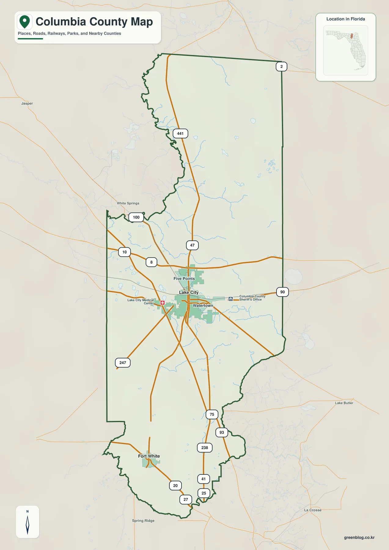
The general county map places Lake City in the northern half of Columbia County, but the I-75/I-10 interchange is northwest of downtown rather than in the middle of the city. The existing FDOT-based material in the package identifies the interchange with I-75 Exit 435 and I-10 Exits 296A and 296B. Downtown Lake City is better located by US 90 running east-west and US 41/441 running through the city area. Keeping those two points separate prevents a common orientation error when reading the county at highway scale.
Five Points appears just north of Lake City, while Watertown is labeled to the east. The county map also shows local facilities such as Lake City Medical Center and the Columbia County Sheriff’s Office, which help indicate where the developed area is concentrated. US 441 extends north through the county, and I-10 crosses the northern half from west to east. Outside the county outline, White Springs and Jasper provide western and northwestern references, while Lake Butler and La Crosse help orient the eastern and southeastern sides.
The population figures already supplied with the package add useful scale. The U.S. Census Bureau reported 69,698 residents in the 2020 Census and estimated 74,094 residents on July 1, 2025. The existing material also lists 797.55 square miles of land. Those numbers fit what the map shows: a recognizable Lake City urban core surrounded by large rural, forested, agricultural, and wetland areas rather than one continuous built-up county.
Fort White Marks the Shift from Highway Country to Spring-Fed Rivers
Fort White lies southwest of Lake City near the meeting of SR 47 and US 27. That location gives the southern part of the county a very different geographic character from the interstate-centered north. Around Fort White, roads are important, but the Ichetucknee and Santa Fe rivers become equally useful references. Following SR 47 south from Lake City is one of the clearest ways to connect the county seat with the spring-and-river landscape near the southwestern boundary.
Ichetucknee Springs State Park lies west of Fort White. The Florida State Parks source already included in the package explains that the park extends across both Columbia and Suwannee counties. The Ichetucknee River is formed by major springs and flows south into the Santa Fe River. The Santa Fe then continues west and eventually joins the Suwannee River. That connected sequence is more useful for map reading than treating the three river names as isolated features.
The southern county map also shows a cluster of numbered roads around Fort White, including 75, 93, 238, 41, 25, 27, and 20. A reader does not need to memorize all of them to understand the area. SR 47 and US 27 provide the clearest road framework, while the Ichetucknee and Santa Fe rivers explain the natural side of the same landscape. For actual driving directions, a current navigation map is still necessary; this county map is best for regional orientation.
The City Map Shows the Large Gap Between Lake City and Fort White
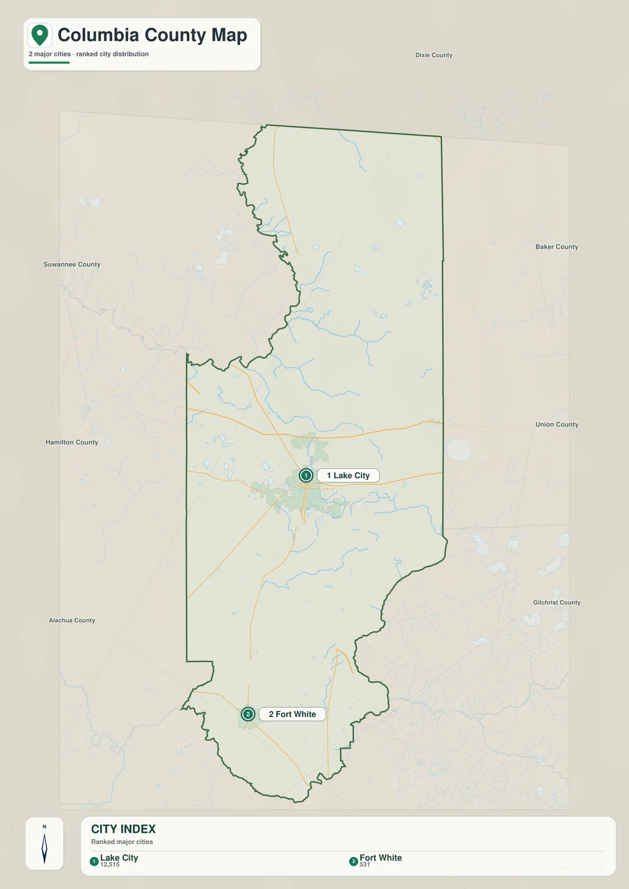
The city map strips away many secondary labels and highlights Lake City and Fort White as the two incorporated municipalities in the package. The CITY INDEX lists Lake City at 12,515 and Fort White at 531, making the size difference obvious as well as the geographic separation. Lake City sits north of the county center, while Fort White is much farther southwest near the river-and-springs area. The map therefore shows two municipal centers separated by a broad rural interior rather than a continuous urban corridor.
Neighboring counties are labeled around the outside: Hamilton to the north, Suwannee to the west, Baker to the east, Union to the southeast, Gilchrist to the southwest, and Alachua to the south. Lake City is closer to the county’s main regional highway connections, while Fort White is more closely associated with the southwestern county edge and the Ichetucknee-Santa Fe river country. Other names seen on the general map, such as Watertown and Five Points, are useful local references but should not automatically be read as equivalent incorporated municipalities.
Lake City functions as the county seat and concentrates most county government and urban services. Fort White is far smaller but gives the southwestern part of Columbia County a clear municipal reference close to US 27, SR 47, and the spring-fed rivers. A county profile that focuses only on Lake City would therefore miss a large part of the county’s geography, especially the southern natural areas and the northeastern forest zone.
Alligator Lake, Falling Creek, and the Southern Rivers Add a Second Map Structure
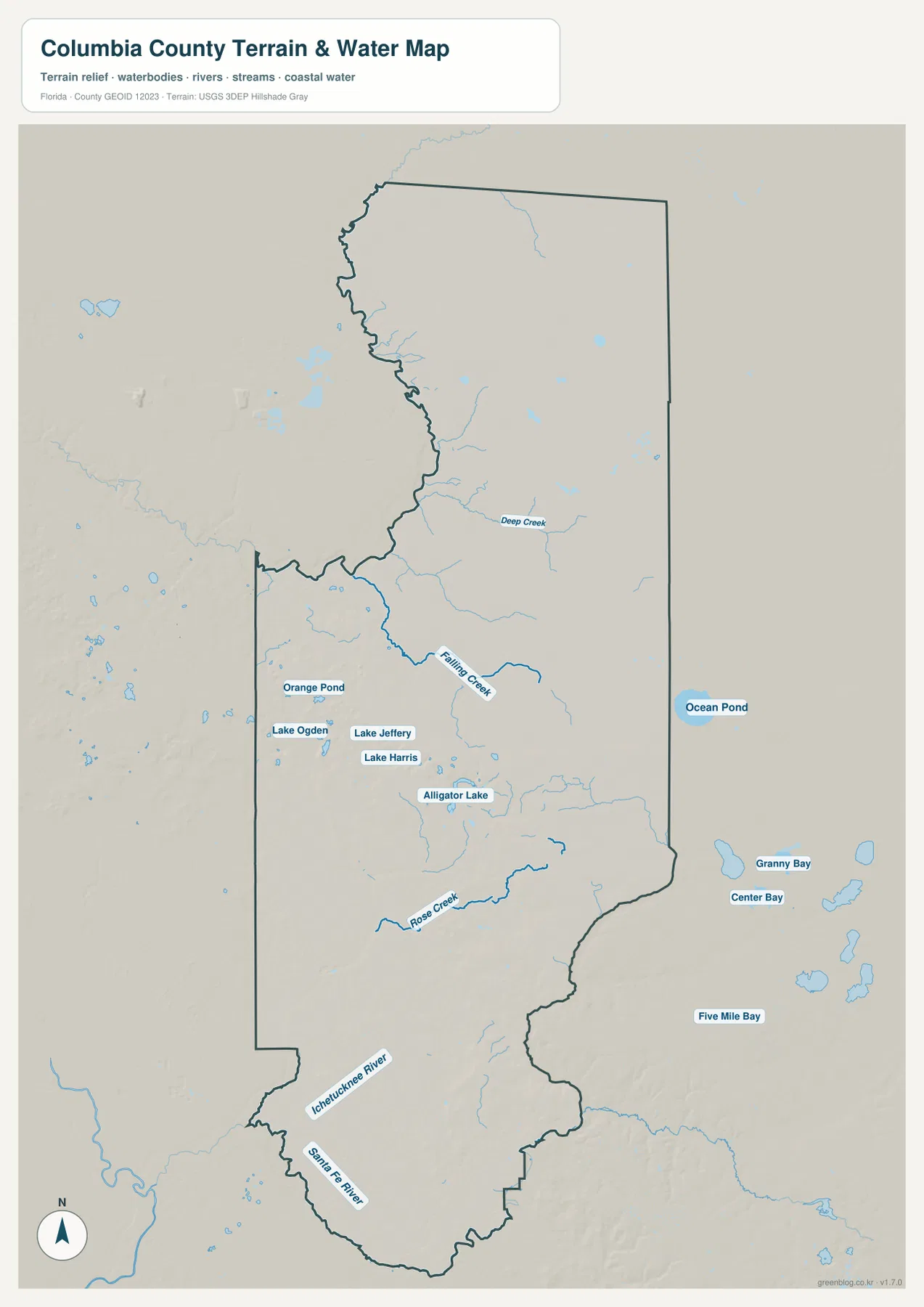
The terrain-and-water map changes the emphasis from roads to water. Alligator Lake is one of the clearest named lakes near the Lake City area. To the northwest are Lake Jeffery, Lake Harris, Lake Ogden, and Orange Pond, while Deep Creek and Falling Creek appear farther north and northeast. These labels make it clear that the Lake City side of Columbia County is not only a highway landscape; small lakes and streams form a second geographic layer around the developed corridor.
Ocean Pond is labeled beyond the eastern side, and the map also shows Granny Bay, Center Bay, and Five Mile Bay southeast of the county. Those surrounding features are useful orientation references and should not all be assumed to lie inside Columbia County. The eastern landscape connects with the Osceola forest region. The U.S. Forest Service source in the package describes the Osceola Wildlife Management Area as extending from northwestern Baker County into northeastern Columbia County, which helps explain why that side of the county carries fewer major settlement labels.
In the south, Rose Creek, the Ichetucknee River, and the Santa Fe River are labeled directly on the water map. The Ichetucknee runs toward the Santa Fe near the Fort White side, and the Santa Fe is an important natural reference along the southern county boundary. The existing USGS source points to a Santa Fe River monitoring location at O’Leno State Park, and the current county material describes the river’s well-known karst behavior in that area, where water goes underground and later re-emerges at River Rise. That southern landscape is very different from the interstate interchange around Lake City.
The Northeast Forest and Southwest Spring Country Create a Strong County Contrast
A Lake City-centered road map does not tell the whole Columbia County story. The northeast connects with the Osceola National Forest landscape of pine flatwoods and wetlands, while the southwest is defined more strongly by groundwater-fed springs, short clear rivers, and the Santa Fe drainage. The northern and central county is where the main regional highways and the largest city are concentrated. These three settings—highway and city, forest and wetland, spring and river—make the county much more varied than its interstate-junction reputation suggests.
That contrast also helps a reader choose the right map. The general county map is best for Lake City, the interstate relationship, road numbers, and surrounding communities. The city map is faster when the question is simply where Lake City and Fort White sit relative to each other. The water map is the better choice for Alligator Lake, Falling Creek, the Ichetucknee River, the Santa Fe River, and the broader wetland landscape. Each map becomes more useful when it is used for the information it shows most clearly.
A County Overview Works Best When Roads and Rivers Are Read Together
For highway orientation, begin with the I-75/I-10 interchange northwest of Lake City, then move separately to downtown along US 90 and US 41/441. For a south-county trip, follow SR 47 toward Fort White and compare that road with US 27, the Ichetucknee River, and the Santa Fe River. For a boundary lesson, use the surrounding labels for Hamilton, Baker, Union, Alachua, Gilchrist, and Suwannee counties. Those county-specific combinations are more informative than treating the map as a generic road diagram.
No elevation map is included in this package, so exact elevations or contour lines should not be inferred from these files. The water map is not a flood-zone, parcel-boundary, engineering, or navigation product, and the county road map does not show live traffic or construction. Within those limits, the supplied maps work well for county profiles, classroom material, trip orientation, and documents that need a clear visual reference for settlements, major roads, lakes, streams, and rivers.
For printing or larger documents, use the ZIP below rather than relying only on the smaller web previews. The archive contains three A3 high-resolution JPG files corresponding to the county, city, and water maps shown on this page. Each JPG can be used separately, so a project can include only the map that fits the task.
Frequently Asked Questions
Do I-75 and I-10 meet in downtown Lake City?
No. The FDOT-based material supplied in the package places the interchange northwest of downtown. Lake City’s central area is better located with US 90 and US 41/441, so the interstate junction and downtown should be treated as two separate map anchors.
How do the Ichetucknee and Santa Fe rivers connect near Fort White?
The Ichetucknee River begins in the spring area west of Fort White and flows south into the Santa Fe River. The Santa Fe forms an important natural reference along the south and continues west toward the Suwannee River. Reading those rivers as one connected drainage sequence makes the southwestern county much easier to understand.
Why does the city map emphasize only Lake City and Fort White?
The package identifies Lake City and Fort White as Columbia County’s incorporated municipalities. Other labels such as Watertown and Five Points help with local orientation, but they are not equivalent municipal entries, so the simplified city map focuses on the two incorporated places.
Map File Information
Download one ZIP containing the three A3 high-resolution JPG files that match the county map, city map, and terrain-and-water map shown on this page.
- Included Files: County map, city map, and terrain-and-water map JPGs
- File Type: ZIP containing 3 JPG files
Related Maps
- Baker County Florida Map
- Blountstown, SR 20, and the Apalachicola River | Calhoun County Florida Map
- Brevard County Map
Sources
- U.S. Census Bureau QuickFacts — Columbia County, Florida — population and land-area reference
- Florida State Parks — Ichetucknee Springs State Park — spring, river, and park-location reference
- Florida Department of Transportation — Official Transportation Map — interstate and highway reference
- U.S. Forest Service — Osceola Wildlife Management Area — northeastern forest-area reference
- U.S. Geological Survey — Santa Fe River at O’Leno State Park — southern river reference
Green Map creates custom-edited map images using open geographic data sources such as geoBoundaries, Natural Earth, OpenStreetMap, and government open data. These maps are edited visual materials, not raw data files, and are provided for education, documents, presentations, and graphic reference.