This Brevard County Map is easiest to understand as a long mainland corridor beside lagoons, islands, and the Atlantic coast. Titusville occupies the northern part of the county, Cocoa and Rockledge form a central cluster, and Melbourne, West Melbourne, and Palm Bay make up the larger southern urban area. East of the mainland, Merritt Island, Cape Canaveral, and Cocoa Beach are separated from the inland cities by broad waters. The page uses only the three map types actually supplied in the package—a county reference map, a major-city map, and a water map. You can download high-resolution JPG versions of all three maps together in the ZIP on this page.
A simple way to orient yourself is to begin with the mainland and then move toward the coast. I-95 and U.S. 1 provide two strong north-south reference lines, while routes such as SR 528, SR 520, and U.S. 192 help explain how mainland communities connect eastward toward the islands and beachside places. The package material identifies Titusville as the legal county seat and Palm Bay as the county’s largest city, while Viera contains a central County Government Center. Those distinctions matter because the administrative seat, largest municipality, and central government campus are not the same geographic point.
Table of Contents
The mainland corridor from Titusville to Palm Bay
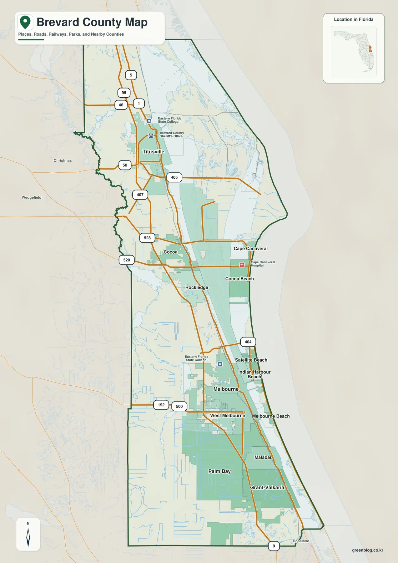
On the county reference map, Brevard County looks long and narrow compared with many inland Florida counties. Titusville is the main northern city shown inside the boundary. Moving south, Cocoa and Rockledge appear in the central part of the county, followed by Melbourne, West Melbourne, and Palm Bay. I-95 stays farther inland and runs almost the full length of the mapped county, while U.S. 1 follows a more easterly line closer to the Indian River side. Those two roads provide an easy framework for locating most of the major mainland communities before adding the more complex coastal geography.
The east-west roads show where the mainland is tied to the coast. Around Titusville, SR 50 reaches the city from the west and SR 405 continues toward the eastern side of the county. In the Cocoa area, SR 528 and SR 520 cross toward Merritt Island and the Cape Canaveral side. Farther south, U.S. 192 and SR 500 cross the Melbourne area, while SR 404 is shown near the central-southern coast. These routes are not presented as a turn-by-turn navigation network; the map is better used to compare the direction of the major highways and to see which urban areas are connected by the same corridor.
The neighboring counties help explain Brevard’s position in east-central Florida. Volusia County is to the north, Orange and Osceola Counties are to the west, and Indian River County is to the south. The Atlantic Ocean is on the east side. The western edge is not simply a straight inland line; the water map shows the St. Johns River system close to that side of the county. This gives Brevard two very different edges: an Atlantic and lagoon coast to the east and wet inland river country along portions of the west.
Six major cities form three distinct parts of the county
The city map isolates six major municipalities and makes their north-south spacing much easier to read. Palm Bay is ranked first on the map and occupies the southern part of the county. Melbourne is immediately to its north, while West Melbourne sits beside the same southern urban belt. Rockledge and Cocoa form a closer pair in the center. Titusville is farther north and stands apart from the central and southern clusters. The result is not one continuous downtown area from end to end, but three recognizable groups: northern Titusville, central Cocoa–Rockledge, and the larger Melbourne–Palm Bay region.
The map also includes comparison values in its city index. They should be treated as values printed on this particular map rather than as a substitute for a current Census lookup, but they still make the relative ranking clear. Palm Bay is shown far above the others, followed by Melbourne and Titusville, then Rockledge, West Melbourne, and Cocoa. For a visitor trying to understand the county, the geographic spacing is more important than the exact figures. The map makes it obvious that the most populated southern communities are well removed from Titusville, even though all of them belong to the same county.
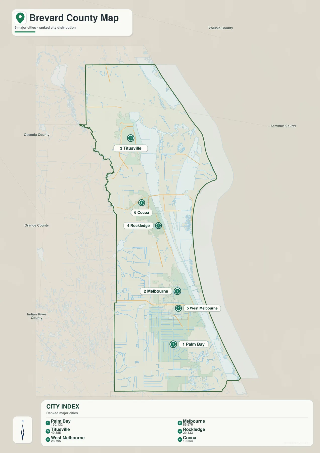
The outer labels reinforce that long shape. Volusia County appears beyond the north end, while Orange and Osceola Counties lie to the west and Indian River County is beyond the southern end. Titusville is comparatively close to the north side, while Palm Bay occupies a large southern area. Cocoa and Rockledge sit in the middle and visually bridge the northern and southern sections. That pattern is useful for planning a regional itinerary, explaining where a community sits within Brevard, or choosing which part of the county to study in more detail.
Indian River waters, the Atlantic, and the western river edge
Brevard’s water geography is the feature that most clearly separates it from a simple strip of coastal development. The water map places the Atlantic Ocean along the full eastern side and labels the Indian River through much of the county. In the north, Griffis Bay and Marsh Bay Cove appear near the Indian River area. Addison Creek is labeled farther south, followed by the Barge Canal and Newfound Harbor in the central county. The map then shows smaller rivers, creeks, and canals around the Melbourne and Palm Bay area, including the Eau Gallie River, Crane Creek, James Green Creek, Sawalice Creek, and the Sebastian Canal.
The St. Johns River appears on the western side, which is important because it shows that Brevard is influenced by major water systems on both sides of the mainland corridor. The Atlantic and lagoon waters dominate the east, while the St. Johns system lies toward the interior. Between them are the roads, cities, wetlands, and lower-density tracts that make up the mainland portion of the county. A large open area on the map should therefore not automatically be interpreted as unused land; in Brevard, broad wet areas, conservation lands, and federal property are part of the regional geography.
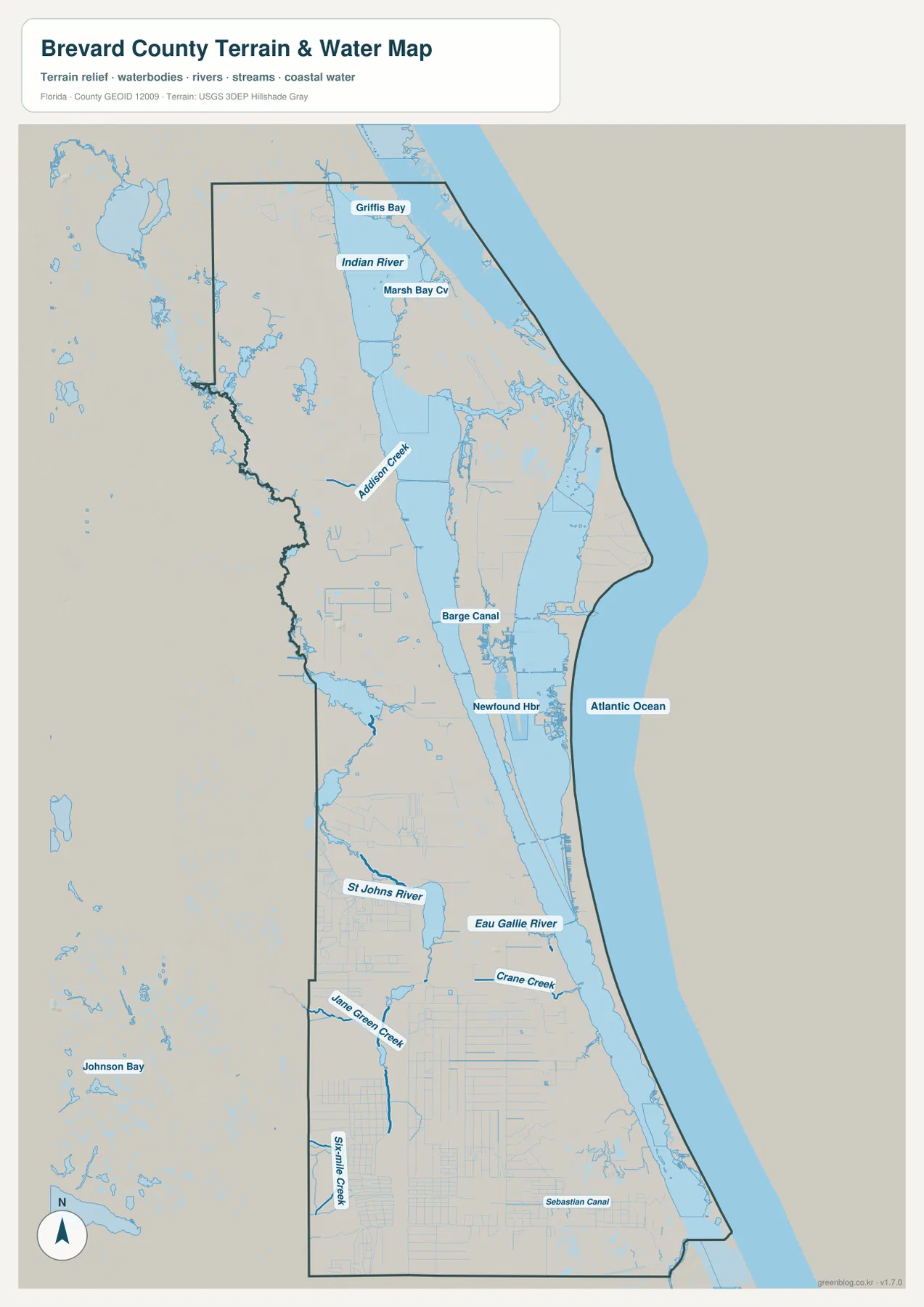
This image is a water-and-terrain reference map, not a flood-risk, navigation, parcel, or depth chart. The background provides some terrain context, but the package does not include a separate elevation map, so the shaded surface should not be used to estimate a location’s exact height or slope. Its strongest use is positional: it shows how long the Indian River extends through the county, where the Atlantic sits relative to the inland communities, where the St. Johns River reaches the western side, and how short local waterways enter the lagoon system around the central and southern cities.
Why the Space Coast label makes sense on a county map
Brevard’s Space Coast identity is tied directly to the northern and central coastal geography. The package’s verified material identifies Kennedy Space Center on northern Merritt Island and places Cape Canaveral and Port Canaveral farther south along the central coast. On the county reference map, the broad area east of Titusville contains far fewer conventional city streets than the mainland corridor. The map therefore helps explain that this is not simply a gap between towns; it is a large zone shaped by federal space facilities, conservation lands, wetlands, and water.
Kennedy Space Center and Merritt Island National Wildlife Refuge occupy overlapping northern coastal geography. The source material in the package describes the refuge as roughly 140,000 acres and notes habitats such as coastal dunes, salt marsh, scrub, pine flatwoods, and hardwood hammocks. That is a very different landscape from the built-up Melbourne–Palm Bay area farther south. Reading the map with this context prevents the northern coastal tract from being mistaken for a large undeveloped suburb. It is a specialized landscape where space operations and protected habitat exist side by side.
The central coast has a different role. Port Canaveral and Cape Canaveral are tied to the Cocoa area by SR 528, and Cocoa Beach lies farther along the Atlantic side. This east-west line combines highway access, port activity, beach communities, and travel related to the space industry. By comparison, the Melbourne–Palm Bay section is a broader residential and urban area that extends southward along the mainland. The county is therefore easier to understand when divided into a northern space-and-conservation zone, a central port-and-beach corridor, and a southern metropolitan belt rather than treated as one uniform coastal strip.
Choosing the map that fits the question
Use the county reference map first when you need boundaries, roads, and a general sense of where the major places sit. It is the best page image for comparing Titusville, Cocoa, Melbourne, Palm Bay, I-95, U.S. 1, and the principal east-west highways in one view. If your question is specifically about the main municipalities, the city map is faster because it removes much of the other detail and emphasizes the six-city distribution. That version is especially useful for seeing how far the northern, central, and southern urban groups are separated.
Use the water map when the location of rivers, lagoons, creeks, canals, bays, and the Atlantic shoreline matters. The Indian River, St. Johns River, Eau Gallie River, Crane Creek, and Sebastian Canal are much more prominent there than on the general map. Comparing maps also gives a richer picture of the same place. Melbourne, for example, appears as a major road-and-city node on the reference map, a second-ranked city in the city index, and a community close to the Indian River and several named waterways on the water map.
The WebP images in the article are sized for quick viewing in a browser. For printing or keeping larger copies, the ZIP below contains the matching high-resolution JPG files for the county map, city map, and water map. Each file can be used separately, and the archive name includes both Brevard County and Florida so it is easy to identify when stored with maps from other counties. These are regional reference maps, however, so legal boundary decisions, surveying, flood determinations, marine navigation, and other precision tasks should rely on the latest specialized records from the responsible agency.
Frequently Asked Questions
Is Palm Bay the county seat of Brevard County?
No. The verified material in this package identifies Titusville as the legal county seat. Palm Bay is the largest city shown in the county material, but largest city and county seat are different concepts. Brevard also has a County Government Center in Viera, so a map reader should distinguish the legal seat in Titusville, the large southern population center around Palm Bay, and the centrally located government campus.
Why do Cocoa Beach and Cape Canaveral look separated from the mainland?
They are part of a coastal system divided by broad lagoon waters and islands. The package material describes the Indian River Lagoon and Banana River as important waters between the mainland, Merritt Island, and the Atlantic-side barrier communities. A useful reading order is to find the mainland first, then the lagoon and island areas, and finally the Atlantic coast. That prevents Cocoa Beach or Cape Canaveral from being mistaken for a simple eastward continuation of the mainland street grid.
Which map should I use to find rivers and canals in Brevard County?
Use the water map. It directly labels features such as the Indian River, St. Johns River, Eau Gallie River, Crane Creek, Sebastian Canal, Barge Canal, and the Atlantic Ocean. If you also need roads and city names, compare the same area on the county reference map afterward. The package does not include a separate elevation map, so the terrain shading on the water image should not be treated as an exact elevation source.
Map File Information
This ZIP contains high-resolution JPG versions of the Brevard County reference map, city map, and water map. Use it when you need files larger than the on-page WebP images.
- Included Files: 3 high-resolution JPG map files shown in this article
- File Type: JPG files in a ZIP archive
- Intended Use: Printing, education, presentations, and map-based projects
Related Maps
Sources and References
- Brevard County Government — county administration and local reference information
- U.S. Census Bureau QuickFacts — Brevard County, Florida — population, land area, and related county statistics
- NASA Kennedy Space Center — Kennedy Space Center and Space Coast context
- U.S. Fish & Wildlife Service — Merritt Island National Wildlife Refuge — northern coastal conservation landscape and habitat information
- Canaveral Port Authority — Port Canaveral — port location and regional access information
Green Map creates custom-edited map images using open geographic data sources such as geoBoundaries, Natural Earth, OpenStreetMap, and government open data. These maps are edited visual materials, not raw data files, and are provided for education, documents, presentations, and graphic reference.