Lee County is compact enough that its road network, two principal city references, and branching waterways can be compared without losing the county boundary. This Lee County North Carolina Map set includes a county map centered on Sanford and the main highways, a city map that isolates Sanford and Broadway, and a terrain-and-water map showing the Cape Fear River with named creeks, small lakes, and ponds. The WebP images on the page are designed for quick viewing, while the download box below provides matching high-resolution A3 JPG files in a single ZIP.
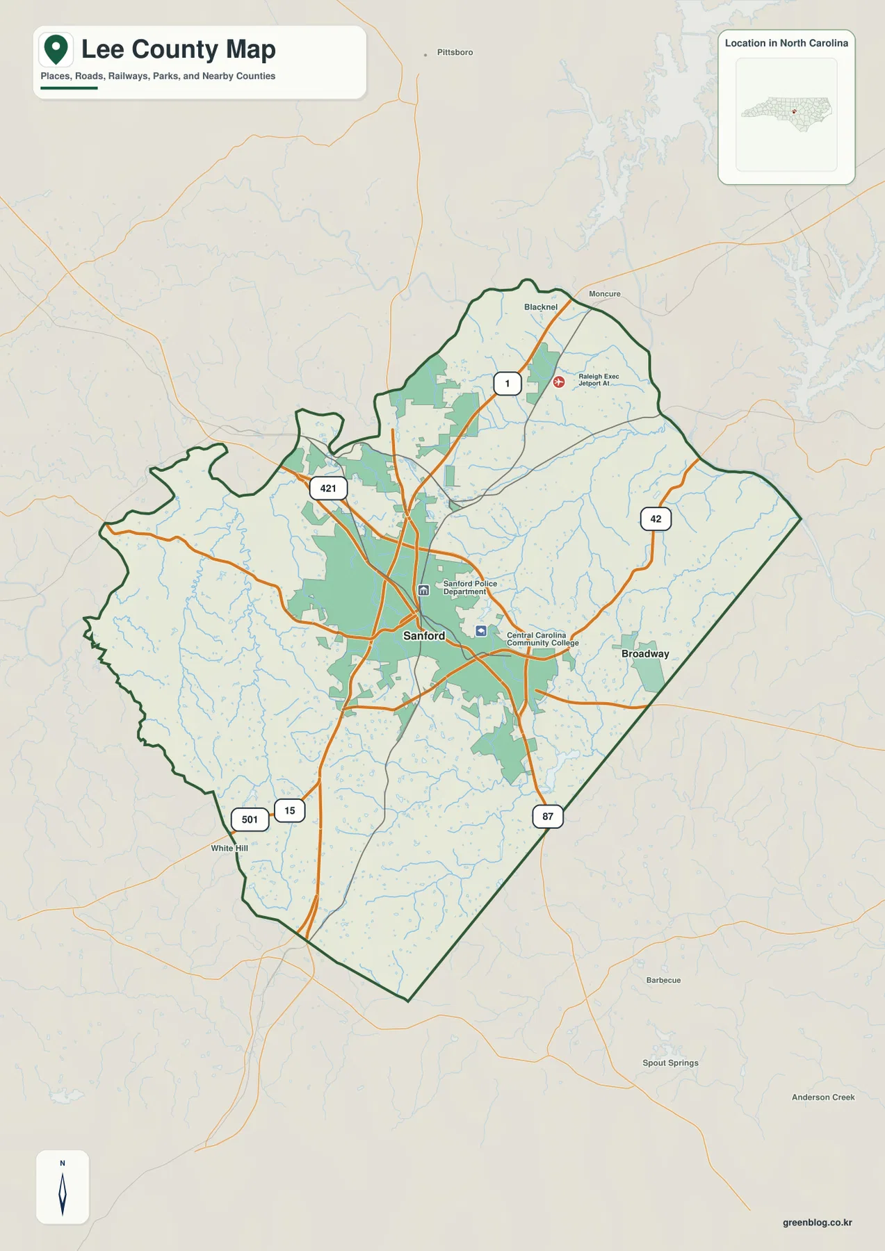
Sanford is the first place to locate because it sits near the middle of the county and is surrounded by the densest road pattern on the general map. US 1 and US 421 approach the northern and central part of the county, US 15 and US 501 are marked toward the south, NC 42 leads east toward Broadway, and NC 87 is visible near the southeastern side. The county outline is irregular rather than rectangular: the western boundary bends repeatedly, the eastern edge runs on a long diagonal, and the county narrows toward its southern end. Reading the roads together with that outline makes the relative positions much easier to remember.
Table of Contents
Sanford is the road-network reference point
On the county map, Sanford is labeled close to the center and is surrounded by the largest green built-up area. Central Carolina Community College and the Sanford Police Department are also marked nearby, adding recognizable local references without turning the map into a street-level guide. From this center, major roads extend in several directions. US 1 continues toward the northern side, US 421 enters from the northwest, and the paired US 15 and US 501 markers appear to the south. Several smaller roads spread outward from the same area, so Sanford works well as the starting point for learning the county’s orientation.
The broader map also prevents Sanford from becoming the only point of reference. Broadway is clearly separated to the east, while a Blacknel label appears near the northern side. Outside the county boundary, places such as Pittsboro, Moncure, White Hill, Barbecue, Spout Springs, and Anderson Creek remain visible as background orientation points. Those labels should not be read as places inside Lee County; the heavy green county outline is the correct guide for administrative location. Their value is directional: they show where the map sits in relation to nearby communities beyond the county line.
Broadway gives the eastern side a second city reference
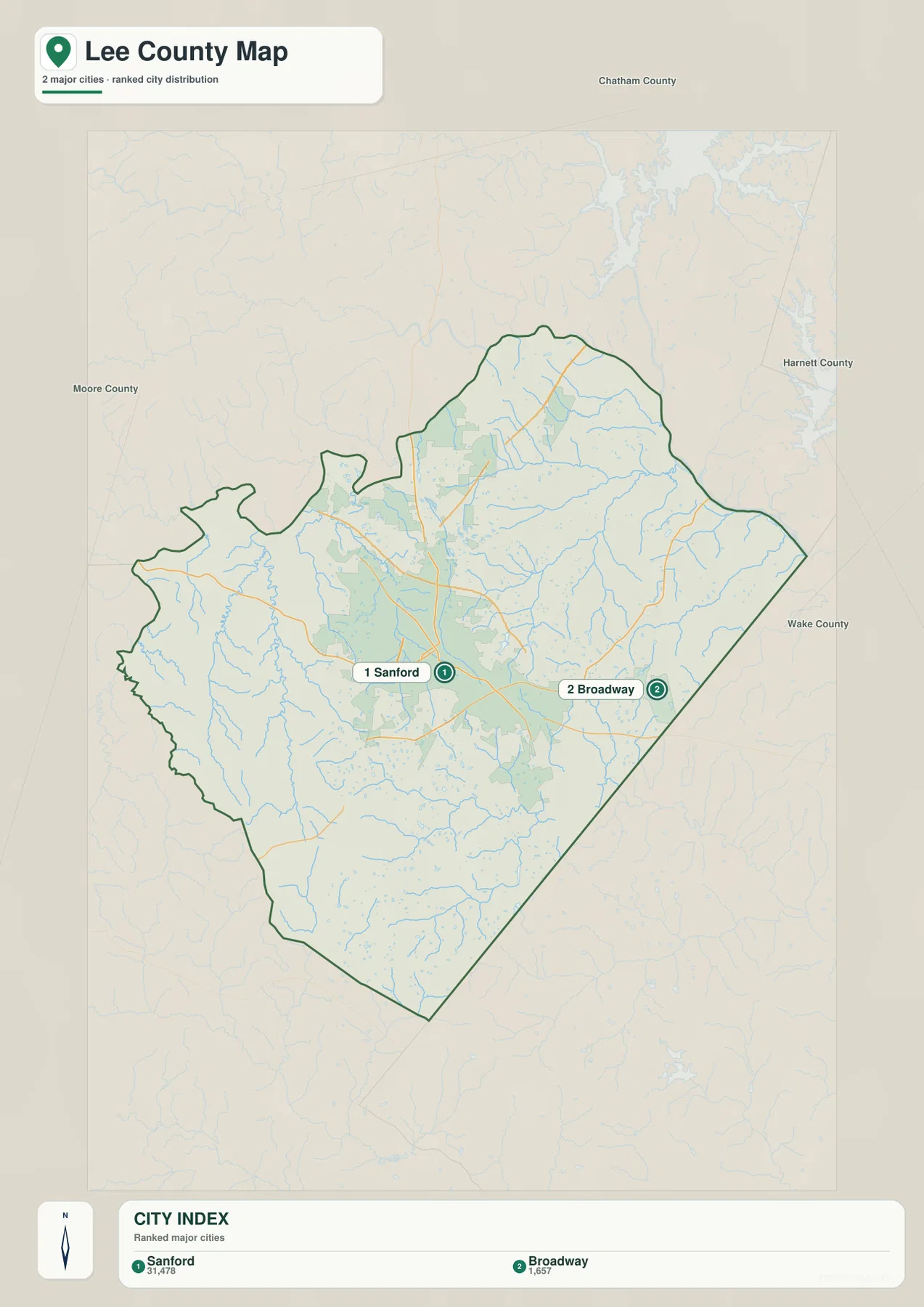
Broadway is much smaller on the map than Sanford, but its location makes it especially useful. It lies close to the long diagonal eastern boundary, with NC 42 providing a clear road reference between the eastern side and the Sanford area. Once Broadway is located, the shape of Lee County’s east side becomes easier to follow because the settlement sits near the part of the outline that descends toward the southeast. Sanford explains the county’s central road concentration; Broadway helps explain where the eastern edge is and how far the county extends beyond the central city.
The city map removes most secondary labels and presents only Sanford and Broadway as ranked major cities. Its City Index lists Sanford at 31,478 and Broadway at 1,657. These should be treated as the values printed on this particular map rather than silently replaced with a different current population series. For map reading, the most useful point is the contrast: Sanford occupies the central portion of Lee County, while Broadway is clearly offset to the east. That simplified view is useful before returning to the general map and adding highways, streams, and the irregular county outline back into the picture.
US 1, US 421, US 15/501, NC 42, and NC 87 divide the travel directions
The highway pattern is useful because each side of Lee County has a different visual cue. US 1 runs across the northern part of the county and passes the Sanford area, while US 421 approaches from the northwest. US 15 and US 501 are marked close together in the southern portion, giving the lower part of the map a clear north-south reference. NC 42 heads toward Broadway on the east, and NC 87 appears near the southeastern diagonal boundary. This is not a navigation map with turn-by-turn routing, but it makes it easy to answer a basic county-scale question: which major route is closest to the part of Lee County you are trying to locate?
Using the county outline at the same time adds another layer of orientation. The west side has several bends and small protrusions, so a road that looks west of Sanford is not necessarily close to a straight county edge. The east side is simpler visually because the boundary forms a long diagonal near Broadway and continues toward the southern point. The north opens into a broader area above Sanford, whereas the south narrows considerably. Remembering those shapes along with the highway numbers is more effective than trying to memorize every local road shown on the map.
Cape Fear River and named creeks organize the water map
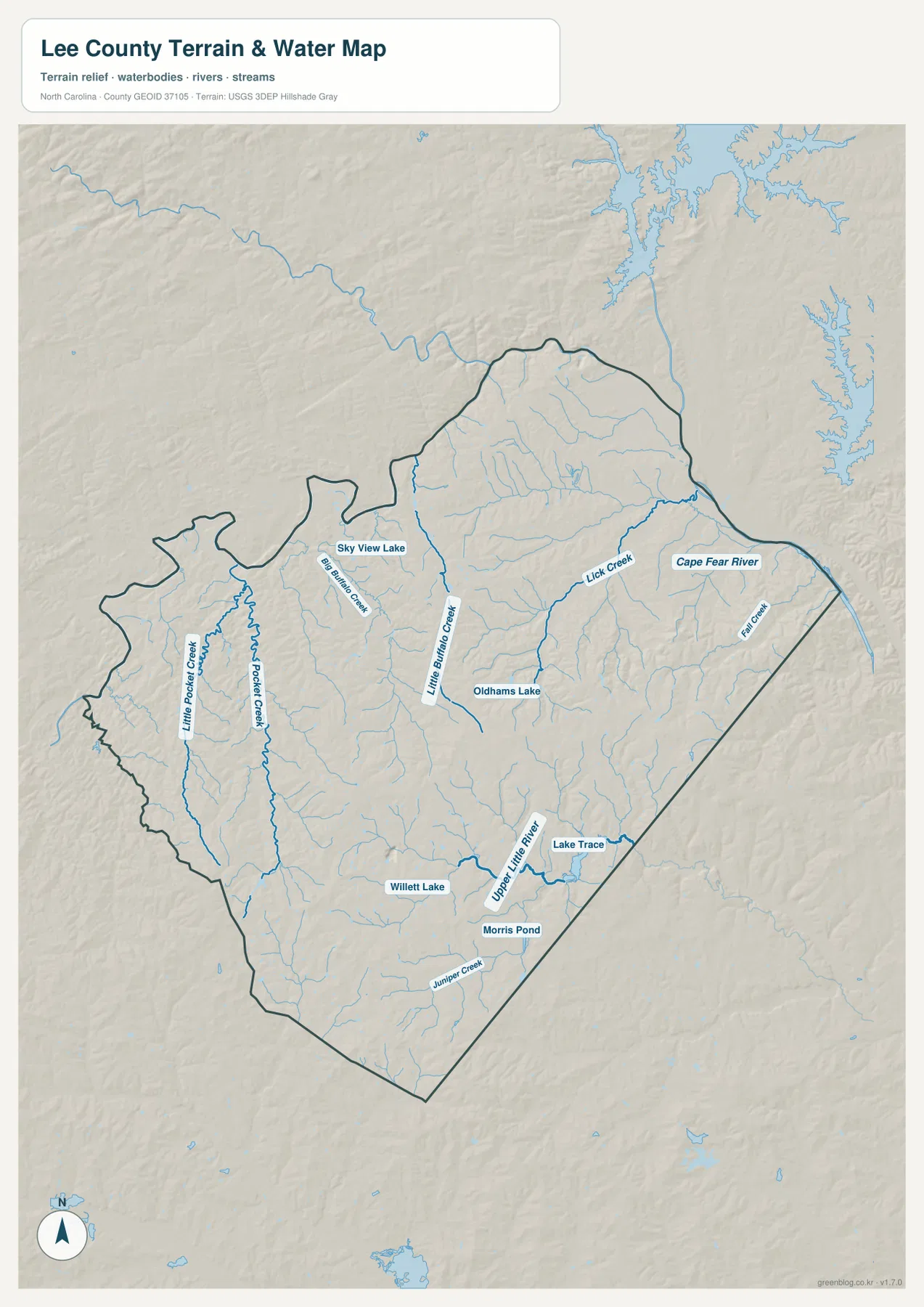
The terrain-and-water map changes the emphasis completely. Roads disappear from the foreground and the Cape Fear River becomes the largest named water feature along the eastern and northeastern side. Lick Creek and Fall Creek are labeled toward that river. Farther inside the county, Little Buffalo Creek forms a long central reference, with Big Buffalo Creek to its west. Pocket Creek and Little Pocket Creek are shown in the western part of the county, while Upper Little River and Juniper Creek appear in the south. Together, these names show that Lee County contains many small drainage lines even though the general road map makes the central urban area the most noticeable feature.
Several smaller water bodies provide additional location clues. Sky View Lake is labeled in the northwestern interior, Oldhams Lake appears nearer the center, and Willett Lake, Morris Pond, and Lake Trace are shown farther south. None of these small water bodies defines the county by itself, but they help a reader place the larger creeks in context. For example, finding Little Buffalo Creek first makes it easier to see where Oldhams Lake lies, while Upper Little River provides a reference for the cluster of southern water features. The result is a more detailed picture of local water geography than the county road map alone can provide.
Relief shading is best used as context, not as a precise elevation scale
The water map includes shaded relief, but it is not a separate elevation map and it does not provide survey-grade height measurements. Within the county, the terrain appears rolling and subdued rather than mountainous, and the shading is most helpful when it is read together with streams and river courses. Instead of trying to infer exact elevations from the tones, look for the subtle low corridors that accompany the longer creeks and for the way tributaries converge toward larger watercourses. A reader who needs exact elevations or engineering-grade slope information would need a dedicated elevation dataset rather than this general-purpose county map.
The western half is especially useful for comparing Pocket Creek, Little Pocket Creek, and Big Buffalo Creek, while the center is anchored by Little Buffalo Creek. On the east, Lick Creek and Fall Creek lead toward the Cape Fear River, producing a different pattern from the western drainage lines. The southern portion has its own references in Upper Little River and Juniper Creek. Seeing those groups separately makes the county feel less like a small ring around Sanford and more like a compact landscape with several distinct water corridors.
A practical way to move from roads to cities to water
For a first look, start with the general county map and find Sanford. From there, identify US 1, US 421, US 15/501, NC 42, and NC 87, then notice how the irregular county outline changes from west to east and from north to south. Next, switch to the city map and compare Sanford with Broadway without the distraction of smaller labels. Finally, use the terrain-and-water map to look at the same directions again after the roads are removed. Cape Fear River, Little Buffalo Creek, the Pocket Creek pair, and Upper Little River then become the main features instead of the highway system.
This sequence is useful because the three maps are not competing versions of the same information. The general map is best when boundaries, named places, and major roads need to be seen together. The city map is intentionally simpler and helps with the relative position of Sanford and Broadway. The water map is the better choice for rivers, creeks, small lakes, ponds, and the background terrain shading. If you begin with the feature that matters to your task and then check the same area on a second map, it is easier to keep road, settlement, and water information from becoming visually crowded.
Choose the map by the question you need to answer
Use the county map when you need to place Sanford or Broadway within the legal county outline, compare the major numbered routes, or see nearby external places for orientation. Use the city map when the only question is where the two ranked city references sit in relation to one another. Use the terrain-and-water map when a creek, river, pond, or small lake is the important feature. Because Lee County is relatively compact on the page, switching among these views is quick and usually more informative than forcing every label onto one image.
The downloadable archive contains the same map types shown on this page as high-resolution A3 JPG files: the general county map, the city map, and the terrain-and-water map. It does not include a separate land-cover map, parcel map, flood-risk map, or dedicated elevation sheet. The JPG files are most appropriate for printing, classroom or document use, and general county-level reference where the boundary, road network, city placement, and water features need to remain readable at a larger size.
Frequently Asked Questions
Which map makes the Sanford–Broadway separation easiest to see?
The city map is the cleanest choice because it reduces the county to the two ranked city references. Sanford appears in the central part of the county and Broadway lies near the eastern boundary. If you also need the road connection, return to the general map and compare Broadway with NC 42 and the highway network around Sanford.
What named waterways can I find besides the Cape Fear River?
The water map labels Lick Creek, Fall Creek, Little Buffalo Creek, Big Buffalo Creek, Pocket Creek, Little Pocket Creek, Upper Little River, and Juniper Creek. It also marks Sky View Lake, Oldhams Lake, Willett Lake, Lake Trace, and Morris Pond, which provide useful local reference points between the larger creek lines.
What files are included in the Lee County download ZIP?
The archive contains three high-resolution A3 JPG files: a general county map with Sanford, Broadway, major roads, and the boundary; a simplified city map; and a terrain-and-water map showing Cape Fear River, named creeks, small lakes, ponds, and relief shading.
Map File Information
The ZIP contains three high-resolution A3 JPG files matching the Lee County general map, city map, and terrain-and-water map shown on this page.
- Included Files: County map JPG, city map JPG, terrain-and-water map JPG
- File Type: One ZIP containing 3 JPG files
Related Maps
Sources and References
Green Map creates custom-edited map images using open geographic data sources such as geoBoundaries, Natural Earth, OpenStreetMap, and government open data.
These maps are edited visual materials, not raw data files, and are provided for education, documents, presentations, and graphic reference.