Lenoir County is easiest to understand by starting with Kinston and then looking outward. On the county map, Kinston sits near the middle of the main road network, while La Grange lies to the west and Deep Run and Pink Hill extend the settlement pattern toward the south. The three maps on this page separate those ideas so the county does not have to be read from one crowded image: one map emphasizes roads and places, another simplifies the relationship between Kinston and the smaller towns, and the terrain-and-water map brings the Neuse River and smaller streams to the foreground.
High-resolution JPG versions are also available as a single ZIP download. The WebP images in the article are intended for quick viewing in a browser, while the downloadable files are better suited to saving, printing, or using as offline reference material. Because the download contains the same three map subjects shown here, you can first decide which view is most useful and then keep the full-size JPG version.
The strongest local pattern is the way Kinston, the road network, and the county’s waterways overlap. Route 70 gives a clear east-west reference through La Grange and Kinston, while routes 258 and 58 help establish north-south orientation. The water map adds a different layer: the Neuse River is prominent, but Falling Creek, Southwest Creek, the Trent River, and several smaller ponds show that the county’s water network is much denser than a road-focused map suggests.
Table of Contents
Kinston gives the county map its clearest reference point
The general county map places Kinston at the center of the most concentrated group of roads and labeled public facilities. Lenoir County Courthouse, Lenoir Memorial Hospital, and Lenoir Community College are all shown around the city, with Jackson Heights immediately to the south. That concentration makes Kinston useful as a starting point even when the destination is elsewhere in the county: once the city is located, the larger roads provide simple directions toward La Grange, Pink Hill, Deep Run, and the northeastern edge near Grifton.
Route 70 runs in from La Grange on the west, crosses the Kinston area, and continues east. Route 258 provides a strong north-south reference through the southern half of the county, while 55 and 903 help define the southwest. North of Kinston, the map shows 148 and 58, and route 11 appears near the northeastern edge. These road numbers matter because the county is not built around a single compact urban area; the map has a noticeably denser center and a much more open pattern toward the outer settlements.
South of Kinston, the map becomes more useful for seeing separation than density. Deep Run is shown well below the city, and Pink Hill sits near the southern boundary. If you are trying to place an address or a community in broad terms, a practical method is to locate Kinston and Route 70 first, then follow the numbered route that leads toward the correct side of the county. That keeps the irregular county outline, the road network, and the destination in view at the same time.
La Grange and Pink Hill show how settlement spreads away from Kinston
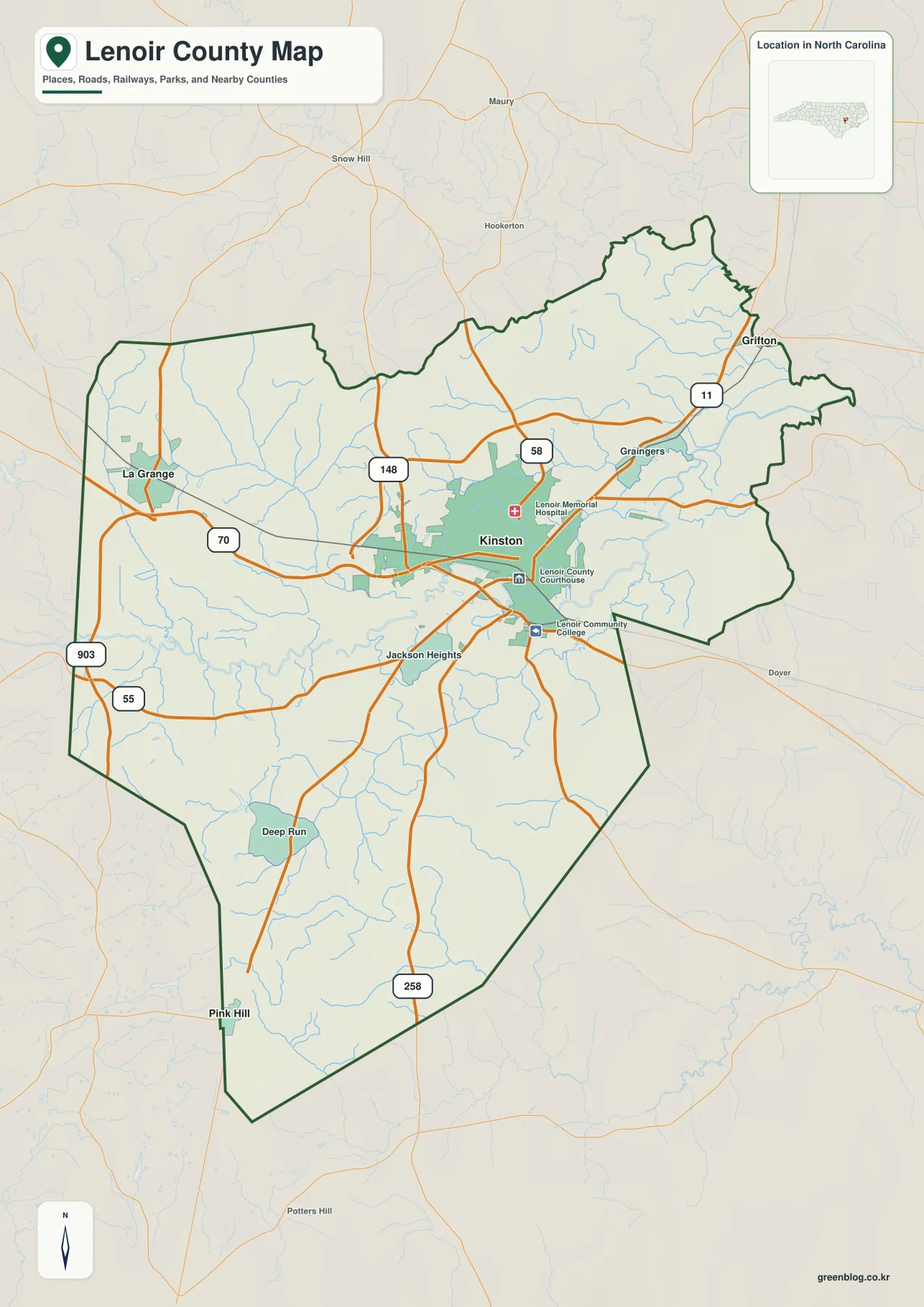
The city-connections map strips away much of the local detail and keeps only three ranked places: Kinston, La Grange, and Pink Hill. Kinston is marked as the hub, La Grange as the second place, and Pink Hill as the third. That simplified presentation is useful when the question is not which road to take, but how the main named settlements are positioned in relation to one another.
The mileage shown on this map is straight-line distance, not driving distance. La Grange is labeled about 11 miles from Kinston, while Pink Hill is about 17 miles away. The difference is visible even before reading the numbers: La Grange sits relatively close to Kinston on the western side of the county, whereas Pink Hill is much farther south. A road trip between the same places may be longer because actual travel follows the road network rather than the direct connector lines used on this map.
Used together, the general map and the city-connections map answer different parts of the same question. The connections view establishes the broad spacing of the three places; the county map then supplies the roads, nearby communities, and boundary shape needed for more detailed orientation. For example, after seeing that La Grange lies west of Kinston, Route 70 on the general map explains the most obvious road relationship between them. Pink Hill, by contrast, is separated from Kinston by a longer north-south span across the southern half of the county.
The Neuse River is only part of a much denser water network
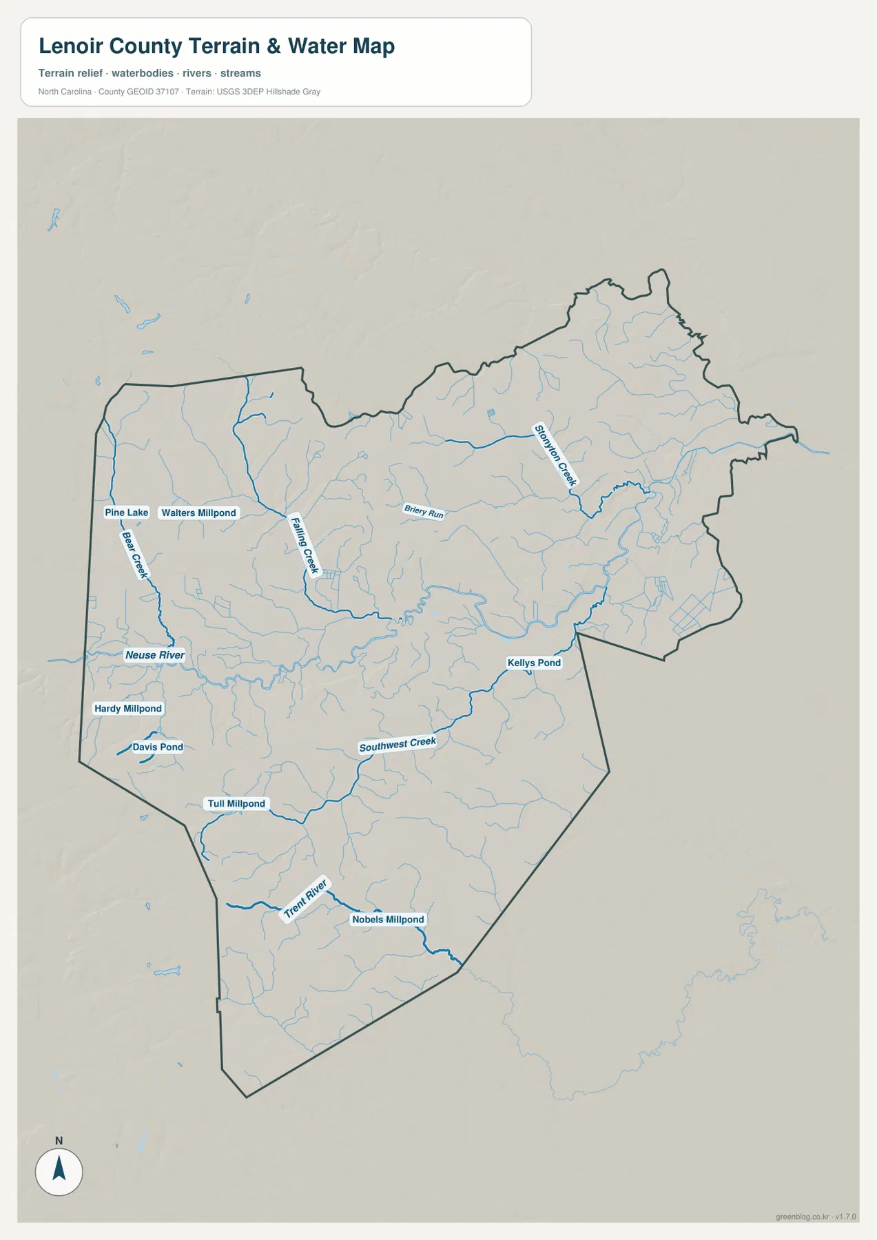
The terrain-and-water map changes the emphasis completely. Instead of making roads dominant, it highlights rivers, creeks, runs, ponds, and millponds in blue. The Neuse River is the most recognizable name, entering from the western side and crossing the central part of the county before continuing east. Around it, smaller tributaries form a branching network that is easy to miss on the general map.
North of the Neuse system, Falling Creek is one of the clearest labeled tributaries, and Briery Run stretches across the central-northern area. Farther northeast, Stonington Creek becomes a prominent local stream. South of the Neuse, Southwest Creek crosses the county and the Trent River provides another major water reference in the southern portion. Looking at these names in sequence shows that Lenoir County is not defined by one river alone; several separate drainage lines divide the map into smaller local areas.
The map also labels smaller standing-water features. Pine Lake and Walters Millpond appear near the west, Hardy Millpond and Davis Pond are south of the Neuse, and Tull Millpond and Nobels Millpond lie farther south near the Trent River system. Kelly’s Pond appears toward the east. These features are useful as local water references, but the map should not be treated as a flood-hazard map, parcel map, or navigation chart. Its purpose is to show the location and relative arrangement of waterways and terrain features at county scale.
Gentle relief makes the creek network easier to notice
The shaded background on the water map does not show dramatic mountain relief. Instead, the surface changes gradually, and the small valleys associated with streams are more important than steep ridges or peaks. That visual character is consistent with the way the water network spreads across the map: many creeks have room to branch through broad, gently changing terrain before joining larger rivers.
This is a generalized terrain reference rather than a survey-grade elevation product. It does not provide exact elevations for individual properties, nor can it determine flood risk, drainage design, or construction suitability. For those tasks, current authoritative elevation, hydrology, and engineering data are required. Here, the shaded relief is most useful as context for understanding why the Neuse, Trent, and smaller creeks occupy the parts of the county that they do.
Choose the map according to the question you are trying to answer
For a first look at Lenoir County, the general map is the most efficient starting point because it combines the boundary, Kinston, smaller communities, and numbered roads. It is also the better choice when you need to relate a place name to a road. After that, the city-connections map can simplify the relationship among Kinston, La Grange, and Pink Hill without the distraction of many secondary features.
If the task is centered on rivers or terrain, begin with the water map instead. Find the Neuse River first, then trace Falling Creek, Southwest Creek, the Trent River, or another named tributary before returning to the general map to see nearby roads and settlements. This two-map comparison is especially helpful because the water view intentionally reduces road detail while the county map does the opposite.
The downloadable JPG files are useful when you want to keep the maps locally or print them at a larger size than the browser preview. The ZIP contains the same county-road, city-connections, and terrain-water subjects shown in the article, so you can save the complete set and use only the view that fits a particular project.
Frequently Asked Questions
Where does the Neuse River appear on the Lenoir County maps?
The terrain-and-water map shows the Neuse River entering from the west and crossing the central part of the county toward the east. Use that map when the river and its tributaries are the priority, and compare it with the general county map when you also need Kinston, numbered roads, or nearby communities.
Are the 11-mile and 17-mile city connections driving distances?
No. The city-connections map uses straight-line distances from Kinston. La Grange is shown at about 11 miles and Pink Hill at about 17 miles. Driving distances can be longer because vehicles must follow the available road network.
What is included in the downloadable ZIP?
The archive contains three high-resolution JPG files covering the same subjects as the article previews: the county road-and-place map, the Kinston-centered city-connections map, and the terrain-and-water map with the Neuse River, Trent River, creeks, ponds, and millponds.
Map File Information
The ZIP contains high-resolution JPG versions of the Lenoir County reference map, city-connections map, and terrain-and-water map.
- File Type: JPG
Related Maps
Sources and References
These official references provide county background and authoritative boundary, hydrography, and elevation data. The maps on this page are designed for general geographic reference; consult current source data directly when a legal, engineering, surveying, or hazard-related decision requires higher precision.
- Lenoir County – About Lenoir County
- U.S. Census Bureau TIGER/Line Shapefiles
- USGS National Hydrography
- USGS 3D Elevation Program
Green Map creates custom-edited map images using open geographic data sources such as geoBoundaries, Natural Earth, OpenStreetMap, and government open data.
These maps are edited visual materials, not raw data files, and are provided for education, documents, presentations, and graphic reference.