Alexander County sits in the western Piedmont of North Carolina, where rolling foothill terrain meets a network of small streams and the long shoreline of Lake Hickory. Taylorsville is the county seat and the easiest reference point for finding the rest of the county, while Hiddenite, Stony Point, and Bethlehem help show how settlement spreads east and southwest from the center. This page brings those places together with the county boundary, numbered highways, waterways, and terrain, and the matching high-resolution A3 JPG map files are available in a downloadable ZIP after the map explanations.
The maps are most useful when they are read as a set rather than as repeated versions of the same picture. The county map keeps roads, communities, nearby counties, and smaller streams visible. The city map strips much of that detail away so Taylorsville can be found immediately, while the terrain-and-water map shifts attention to Lake Hickory, the Lower Little River system, the South Yadkin River, and the many creeks that cut across the foothills. Choosing the map that matches the question makes the county much easier to understand.
A good way to begin is to place Taylorsville near the middle of the county, then follow the east-west road corridor toward Hiddenite and Stony Point or the southwest route toward Bethlehem. After that basic orientation is clear, the water map explains why the county does not look flat or uniform: ridges and narrow valleys are more obvious in the north and northwest, while the southern edge is strongly shaped by Lake Hickory and its tributaries.
Table of Contents
Roads and communities radiating from Taylorsville
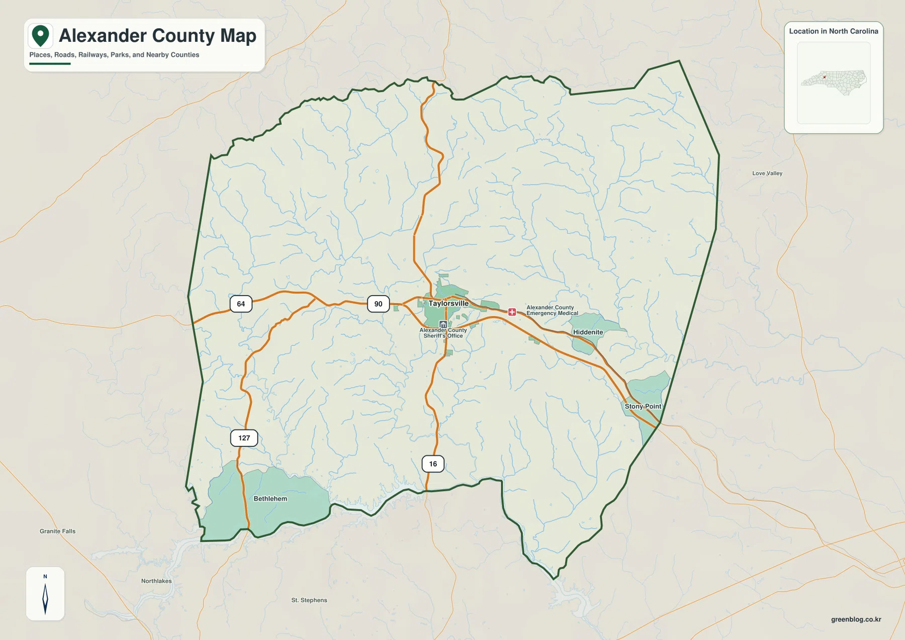
Taylorsville functions as the county seat and as the clearest road reference on the supplied county map. U.S. 64 and North Carolina 90 form the main east-west route through the central part of the county. North Carolina 16 runs through the Taylorsville area on a north-south line, and North Carolina 127 heads toward the southwest and Bethlehem. The official Alexander County government overview also identifies U.S. 64 and NC 90, 16, and 127 as the principal highways serving the county, so the road pattern shown on the map matches the routes residents use to connect the county seat with surrounding communities and neighboring counties.
East of Taylorsville, Hiddenite appears along the central road corridor, with Stony Point farther to the southeast near the Iredell County side. Bethlehem lies in the southwest, close to the northern shore of Lake Hickory. These labels provide a practical set of anchors: instead of trying to recognize every curve in the county boundary at once, a reader can start with Taylorsville, move east toward Hiddenite and Stony Point, or turn southwest toward Bethlehem and the lake.
The neighboring counties also make the outline easier to place within western North Carolina. Wilkes County is to the north, Iredell County to the east, Catawba County to the south and southwest, and Caldwell County to the west. Those four neighbors are also listed by NCpedia. Seeing their names around the outside of the map helps explain where the local roads continue after they leave Alexander County and why the county is often described as part of the foothill area between larger regional centers around Hickory and Statesville.
The map is especially useful for noticing that development is not spread evenly across the county. Road and facility labels are denser around Taylorsville and the central corridor. Hiddenite and Stony Point form additional reference points to the east, while broad areas to the north and west contain fewer prominent settlement labels and a much denser network of small streams. That difference matters when the map is used for local orientation, because a short straight-line distance can cross rolling terrain and multiple drainage valleys.
Four place names that make the county easier to orient
Taylorsville is the official county seat, but a map of Alexander County becomes more useful when several other communities are kept in view. Hiddenite lies east of Taylorsville, Stony Point is farther southeast near the county edge, and Bethlehem occupies the southwest close to Lake Hickory. NCpedia also identifies these communities among the notable places in the county, and the county transportation planning material treats Taylorsville, Bethlehem, Hiddenite, and Stony Point as important local hubs in a largely rural landscape.
Hiddenite is useful for following the eastward continuation of U.S. 64 and NC 90 from the county seat. Stony Point gives the southeast corner a recognizable label and helps readers see the approach to Iredell County. Bethlehem, by contrast, belongs to a different part of the map: it is reached by following NC 127 southwest and sits much closer to the lake. These differences keep the county from being reduced to a single Taylorsville-centered picture.
- Central county: Taylorsville, county offices, and the meeting of the major numbered routes.
- East and southeast: Hiddenite and Stony Point, with roads continuing toward Iredell County.
- Southwest: Bethlehem, NC 127, and the Lake Hickory shoreline.
- North and northwest: more pronounced foothill relief, many small streams, and the Wilkes and Caldwell County sides.
These directions are only a reading aid, not a new set of administrative districts. The actual boundary is irregular, and roads, streams, and local communities do not line up in neat blocks. Using the four place names as anchors simply makes it faster to move from the county-scale view to a specific road, creek, or neighboring county without losing orientation.
Why the city map gives Taylorsville a simpler frame
The city map intentionally reduces the amount of information on the page and highlights Taylorsville as the ranked major city in the supplied city index. It also keeps the surrounding county directions visible, with Wilkes to the north, Iredell to the east, Catawba to the south, and Caldwell to the west. This makes the image useful when a report, lesson, or slide needs a quick answer to one question: where is Taylorsville inside Alexander County?
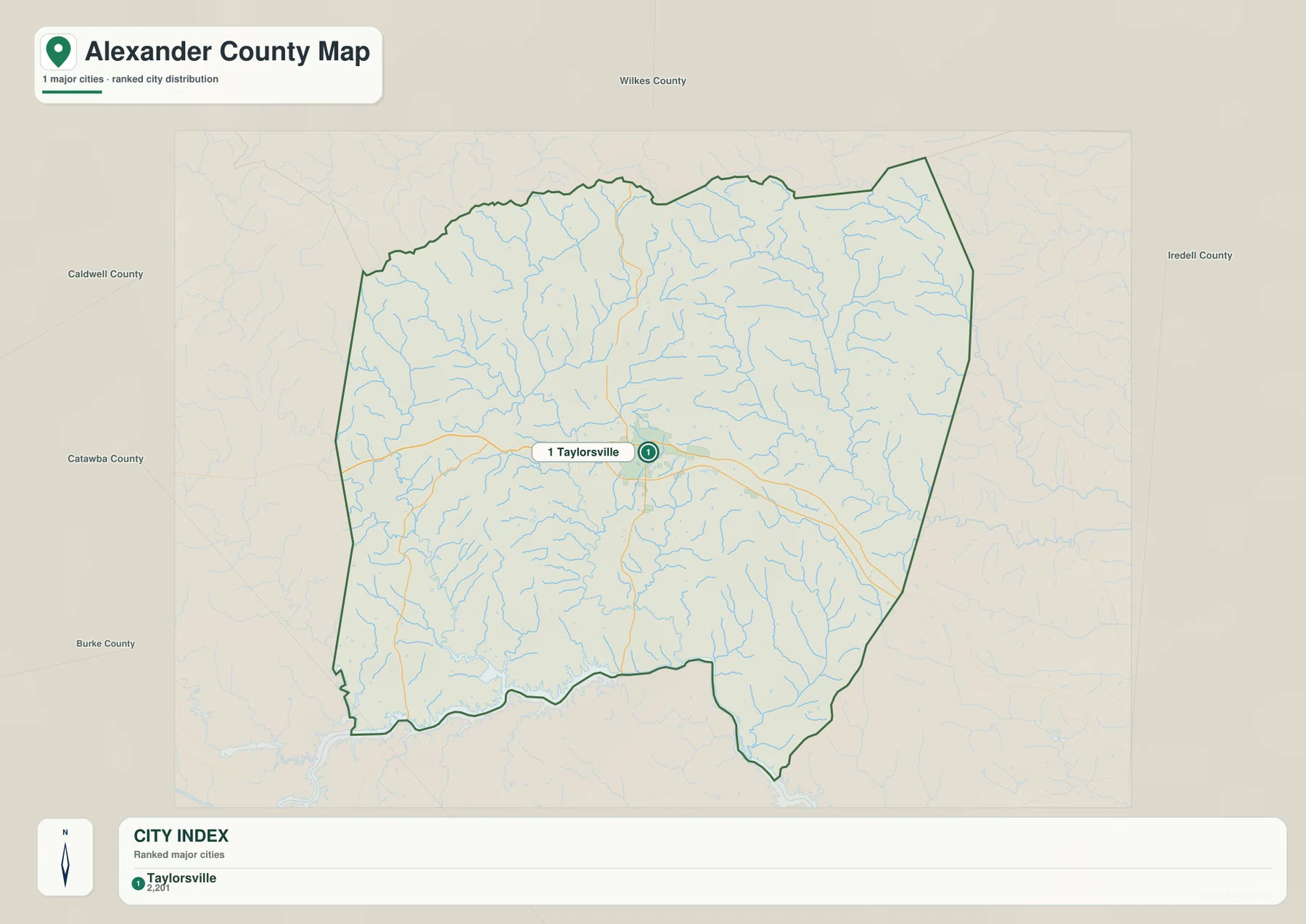
The single highlighted city should not be read as evidence that Hiddenite, Stony Point, or Bethlehem are unimportant. It reflects the purpose of the city-index map, which is to keep the main ranked city label easy to find. The county map is the better choice when several communities, highways, facilities, and local roads need to be compared. Using the two maps together prevents a simplified city index from being mistaken for a complete settlement map.
Taylorsville also works well as the visual center because the major roads pass through or near it. From this central point, U.S. 64 and NC 90 extend east and west, NC 16 provides a north-south reference, and NC 127 leads toward Bethlehem. That arrangement gives the city map more meaning than a simple dot in the middle of the county: it marks the place from which many of the most useful directional comparisons begin.
Lake Hickory and the stream network across the foothills
The terrain-and-water map changes the emphasis completely. Lake Hickory is the most prominent body of water, forming a long, irregular feature along the southern and southwestern edge of the county. Bethlehem lies close to this side of the county, so switching from the road map to the water map immediately explains why the southwest has a different visual character from the central Taylorsville area. The lake shoreline is deeply indented, and many smaller channels approach it from the interior.
Farther north, the map labels the Lower Little River and the East Prong Lower Little River in the northwest, along with the Middle Little River and Duck Creek farther west. The north and northeast include Rocky Creek and the South Yadkin River, while Grassy Creek, Wallace Creek, Third Creek, and Elk Shoals Creek mark additional drainage lines across the interior and eastern side. These named streams are surrounded by many smaller blue tributaries, making it clear that Alexander County is cut by numerous narrow valleys rather than dominated by one single river channel.
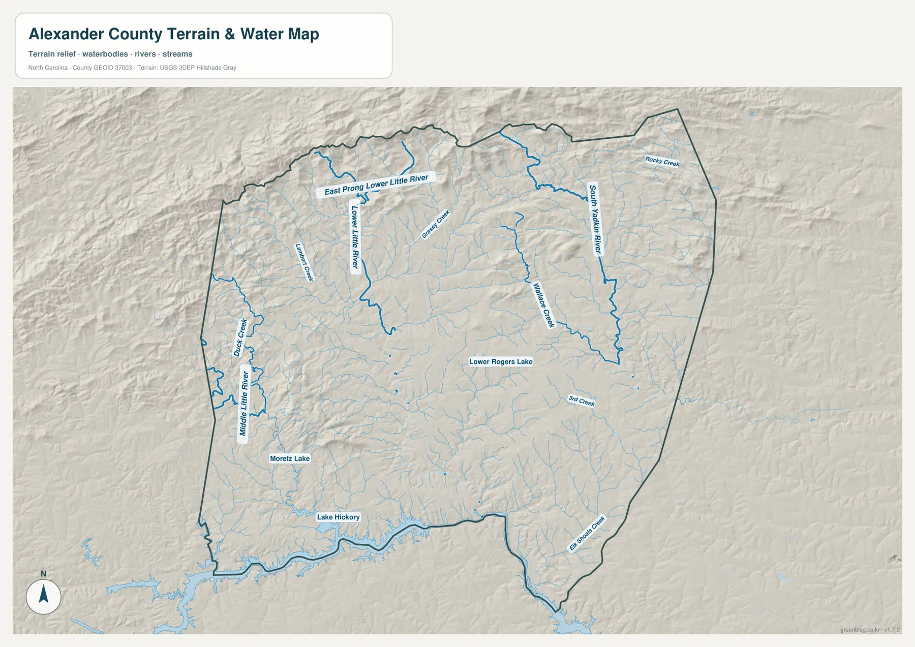
The map also identifies smaller water bodies such as Lower Rogers Lake and Moretz Lake. They are minor compared with Lake Hickory, but their inclusion helps show how water is distributed throughout the interior. In the northwest, the stream lines follow more visibly broken relief, while the southern drainage becomes easier to connect with the Lake Hickory shoreline. The shaded terrain behind the streams is important because it shows the ridges that separate neighboring valleys.
Alexander County government describes the area as a foothill landscape of rolling hills, and the water map makes that description visible without requiring technical terrain analysis. The north and northwest show stronger ridge-and-valley texture, while the central and southern areas open into broader rolling ground before reaching the lake. This does not mean the south is flat; rather, the visual contrast is between more rugged upland relief and lower valleys associated with the larger water bodies.
What becomes clearer when road and water maps are compared
The county map and the water map answer different kinds of location questions. If the goal is to travel from Taylorsville toward Hiddenite or Stony Point, the numbered highways and community labels are the first details to use. If the goal is to understand Bethlehem in relation to Lake Hickory, or to trace the streams in the northern foothills, the terrain-and-water map is more informative. Switching between the two makes it possible to connect human routes with the natural shape of the county.
One useful example starts with NC 127 on the county map. Following it southwest from the Taylorsville area leads toward Bethlehem. On the water map, that same part of the county sits just north of Lake Hickory, so the community can be understood not only as a road location but also as a lakeside part of Alexander County. A second example follows U.S. 64 and NC 90 eastward toward Hiddenite and Stony Point, then uses the water map to show the creeks and rolling terrain around that corridor.
The city map can serve as the first step when only a broad orientation is needed. Find Taylorsville, move to the county map for roads and additional communities, and then open the water map for streams and relief. There is no required order, however. Someone researching a creek can begin with the water map, while a visitor looking for a community can start with the county map and use the other images only when more geographic context is needed.
Choosing the right file for printing or local reference
The county map is the strongest choice when a printed page needs boundaries, highways, several community labels, and surrounding-county context at the same time. The city map is cleaner when the only purpose is to show where Taylorsville sits inside Alexander County. The terrain-and-water map is better for lessons or reference material about Lake Hickory, named streams, foothill relief, or the relationship between valleys and settlement. Selecting one map for one clear purpose usually produces a more readable document than shrinking all three images onto a single page.
The WebP images in the article are previews for on-screen viewing. The download package contains three high-resolution A3 JPG files: the county map, the city map, and the terrain-and-water map. Those JPGs are the better option for printing, editing, or placing in a document because they preserve more detail than the web previews.
After downloading the ZIP, each JPG can be used separately. A county overview handout can use the road-and-boundary map, a simple presentation can use the Taylorsville city map, and a geography or watershed discussion can use the terrain-and-water image. The archive keeps all three together so the reader can choose the level of detail needed without returning to the page to collect separate files.
A few geographic details worth remembering
Alexander County was formed in 1847, and Taylorsville became its county seat. NCpedia places the county in North Carolina’s western Piedmont and lists Caldwell, Catawba, Iredell, and Wilkes as its neighbors. The county government describes a foothill setting with rolling hills and agricultural landscapes. Those descriptions fit the supplied maps: the county has a central road hub at Taylorsville, more broken relief to the north and west, and a strong southern water feature in Lake Hickory.
Administrative boundaries, travel routes, and drainage lines should not be expected to follow the same shapes. The county boundary is a legal outline, while roads continue into neighboring counties and streams cross or approach the boundary according to the terrain. That is why the maps are most informative when the boundary is treated as one reference among several. A route toward Iredell or Caldwell, for example, remains meaningful even after it passes outside the dark county outline.
Lake Hickory and U.S. 64 provide two very different orientation tools. U.S. 64 helps explain east-west travel and the relationship among Taylorsville, Hiddenite, and the surrounding road system. Lake Hickory, by contrast, marks the lower southern edge and helps place Bethlehem within the county’s natural landscape. Adding the smaller rivers and creeks shows how the spaces between those major references are divided by rolling ridges and drainage valleys.
Frequently Asked Questions
How are Taylorsville and Hiddenite positioned on the Alexander County map?
Taylorsville is near the center of the county, while Hiddenite lies to the east along the central road corridor. U.S. 64 and NC 90 provide the clearest road references between them, and Stony Point appears farther southeast near the Iredell County side. For a quick directional explanation, start at Taylorsville and follow the eastward routes toward Hiddenite before looking farther toward Stony Point.
Where is Lake Hickory in relation to Alexander County?
Lake Hickory follows much of the southern and southwestern edge shown on the terrain-and-water map. Bethlehem is close to the lake on the southwest side of the county. The water map is the best supplied image for seeing the lake’s irregular shoreline, nearby tributaries, and the shaded terrain around the southern valleys.
Which map is best for roads and community names?
Use the county map when highways, boundaries, Taylorsville, Hiddenite, Stony Point, Bethlehem, and nearby county directions need to be visible together. The city map is intentionally simpler and emphasizes Taylorsville, while the terrain-and-water map is designed for Lake Hickory, rivers, creeks, and relief. The three files cover different needs rather than duplicating the same information.
Map File Information
Download the Alexander County boundary-and-road map, Taylorsville city map, and Lake Hickory terrain-and-water map as high-resolution A3 JPG files.
- Included Versions: county map, city map, terrain and water map
Related Maps
Sources and references
- NCpedia – Alexander County geography and county information
- Alexander County Government – county overview, history, and major highways
- Alexander County GIS – county mapping and available geographic layers
- USGS National Hydrography – national water data
- U.S. Census Bureau TIGER/Line – boundary and road data
Green Map creates custom-edited map images using open geographic data sources such as geoBoundaries, Natural Earth, OpenStreetMap, and government open data.
These maps are edited visual materials, not raw data files, and are provided for education, documents, presentations, and graphic reference.