Anson County is easiest to understand by starting at Wadesboro and then following the roads, towns, and waterways that spread toward the county edges. This Anson County Map places Wadesboro near the center of the road network, with Polkton to the west, Lilesville to the east, Ansonville to the north, and Morven to the south. The page also includes a separate city map and a terrain-and-water map. High-resolution JPG versions of all three maps are available together in the download box below.
The maps are useful for different kinds of questions. The general county map provides the clearest view of roads, settlements, the county outline, the airport, and the courthouse. The city map reduces some of that detail so the distribution of six named towns is easier to compare. The water map shifts attention away from the road network and toward creeks, lakes, reservoirs, and the broad river along the eastern side. Reading them together makes it possible to move from a simple location question to a more detailed picture of how Anson County is organized.
Table of Contents
Wadesboro at the center of the road network
Wadesboro is the strongest visual reference point on the general county map because several roads meet around it and then separate toward different parts of the county. Route 74 forms the clearest east-west line. It comes from the Polkton side, passes through Wadesboro, and continues toward Lilesville. That single route links three of the most visible settlements on the map and provides an easy way to establish direction before looking at smaller roads or streams.
Other numbered roads spread away from the Wadesboro area in several directions. Route 109 appears in the southwest, Route 742 runs south from the central area, and Routes 52 and 145 are shown toward the southeastern side. Route 218 is marked near Polkton. North of Wadesboro, the map also shows a road connection toward Ansonville. The result is not a simple grid. Instead, the roads converge around the county seat and then fan outward toward smaller communities and the outer boundary.
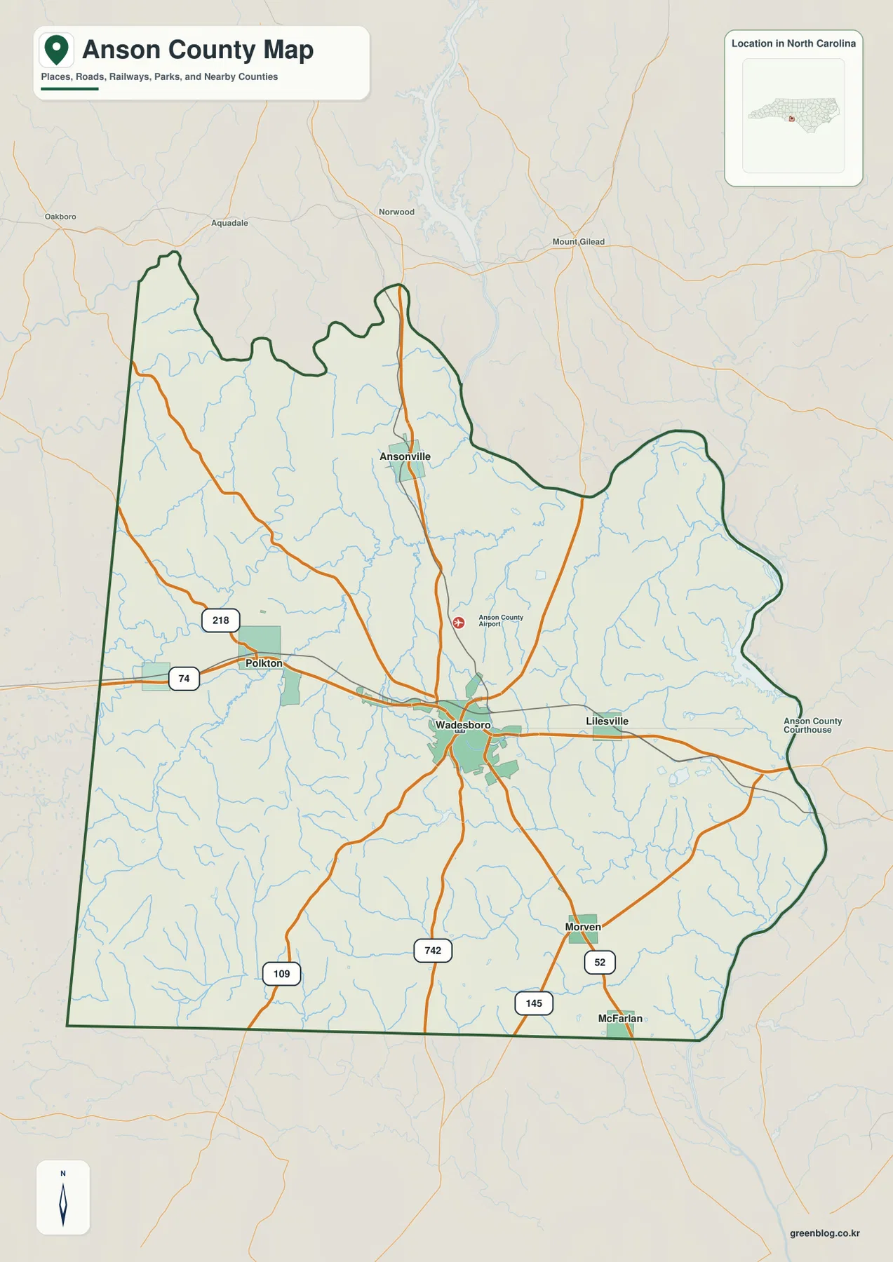
The Anson County Airport is labeled north of Wadesboro, while the courthouse appears farther east on the map. These points help distinguish the main road-and-town map from a purely decorative boundary outline. It can be used to see where local destinations sit in relation to the county seat, but it is best treated as an orientation map rather than a street-by-street navigation product. Its main strength is showing how named places and major routes fit inside the county as a whole.
Six towns spread across different parts of Anson County
The city map highlights six communities: Wadesboro, Polkton, Lilesville, Ansonville, Peachland, and Morven. Wadesboro is ranked first on the map, with Polkton second and Lilesville third. Ansonville, Peachland, and Morven follow. The ranking is useful, but the more important feature for reading the county is where the towns are placed. They are not clustered in one compact urban area. Instead, they provide reference points for the center, west, east, north, and south.
Polkton lies west of Wadesboro and sits close to the Route 74 corridor. Lilesville is east of Wadesboro, also near that east-west route. Ansonville is clearly separated to the north, while Morven anchors the southern part of the city map. Peachland is positioned near the western edge, close to the Union County side. This distribution makes the city map particularly useful when a reader needs to describe the county without treating Wadesboro as the only meaningful location.
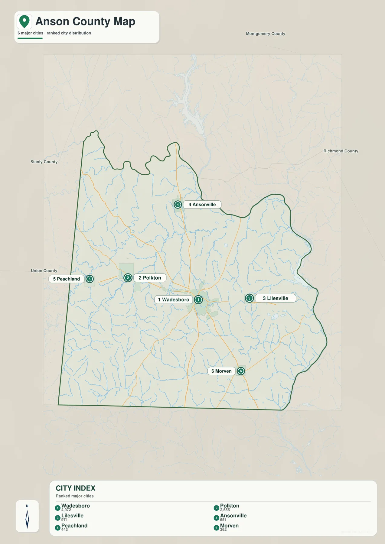
The map also labels neighboring counties outside the Anson boundary. Stanly County is shown to the northwest, Union County to the west, Montgomery County to the north, and Richmond County to the east. Those labels provide context for towns near the edges. Peachland, for example, is easier to place when the Union County side is visible, while Lilesville can be read in relation to Richmond County. The surrounding names make the map more useful for regional orientation without adding unnecessary local street detail.
Creeks and lakes form a dense water network
The terrain-and-water map reveals a different side of Anson County. Small streams appear throughout the county, and several are labeled by name. Lanes Creek runs through the western side, while Brown Creek is visible farther toward the center. Cedar Creek appears in the northeastern portion of the county. In the south and southeast, Jones Creek and South Fork Jones Creek provide additional named references. These waterways are much easier to see on the water map than on the general road map.
Named lakes and ponds are also distributed across the map rather than concentrated in one location. D and J Farms Lake and Jones Pond are shown in the northwest. Wadesboro Municipal Lake and Frank Little Pond lie closer to the central-southern area. Farther east, Hogan Lake, Bonsal Company Lake, and W R Bonsal Tailings Reservoir appear in the same broad part of the county, while Nelson Lake is labeled near the southeastern edge. These features make the water map useful for locating smaller named waters that would be easy to miss on a road-focused map.
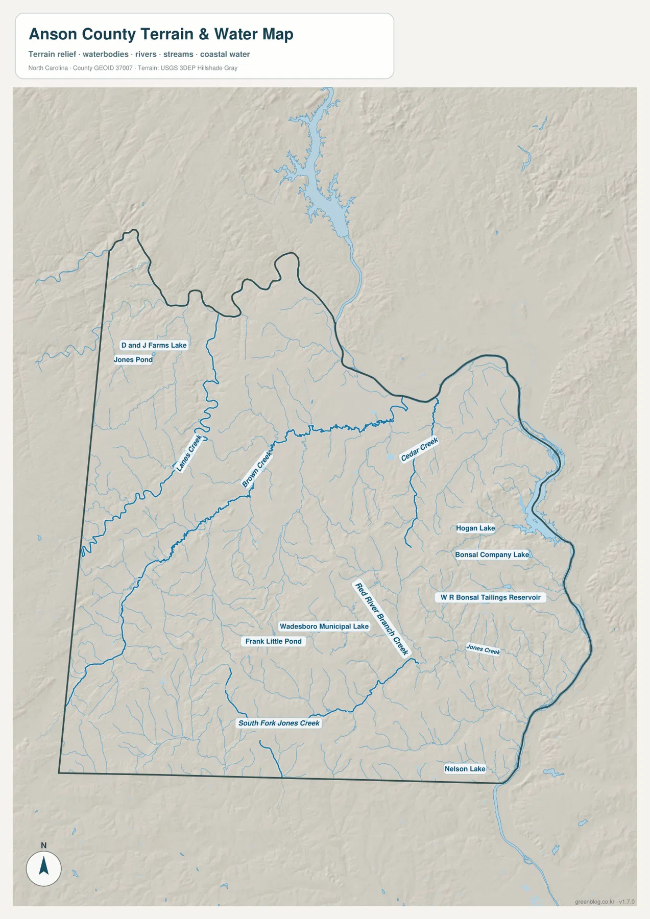
Shaded relief is included behind the water features, but the map does not present spot elevations or a detailed elevation scale. It is therefore better for seeing the relationship between landform and drainage than for measuring height. The relief suggests gently rolling ground cut by many small stream valleys. The branching blue lines make that pattern visible even where no town label is nearby, adding natural reference points to parts of the county that look relatively open on the city map.
The Pee Dee River gives the eastern side a clear natural reference
The eastern side of Anson County is easier to interpret when Lilesville and the Pee Dee River are considered together. Lilesville sits east of Wadesboro along the Route 74 direction, while the large river lies farther toward the county edge. On the general map, this creates a simple progression from the county seat to an eastern town and then to the river-side boundary. It is a practical way to explain direction without relying on compass labels alone.
The water map adds detail to that eastern setting. Cedar Creek descends through the northeastern area, and Jones Creek is labeled farther south. Several lakes and reservoirs also appear east of the county center. When the road and water maps are compared, the eastern side no longer looks like a blank space beyond Lilesville. It contains a distinct set of waterways and named waters that provide natural reference points in addition to roads and town locations.
Choosing the map that fits the task
For a quick county overview, the general map is the best starting point. It shows the county outline, Wadesboro, the other visible towns, major numbered roads, the airport, the courthouse, and a large amount of stream detail without making any one layer dominant. It works well for presentations, basic county orientation, or any task where the reader first needs to understand how the main settlements relate to one another.
The city map is more effective when settlement distribution matters. Because the six highlighted towns are numbered and labeled, it is easy to compare Wadesboro with Polkton, Lilesville, Ansonville, Peachland, and Morven. The neighboring county names add context for places near the boundary. This makes the map useful for explaining which communities lie west, east, north, or south of the county seat without crowding the page with too many secondary labels.
The water map should be used when rivers, creeks, lakes, or the shape of the terrain are the main subject. It brings Lanes Creek, Brown Creek, Cedar Creek, Jones Creek, South Fork Jones Creek, Wadesboro Municipal Lake, and several eastern lakes into view. Because the shaded relief remains visible underneath, it also shows how the stream network cuts across the county. Moving between the three maps lets a reader separate road-based orientation from settlement patterns and natural drainage rather than forcing all information into one crowded image.
Frequently Asked Questions
Why is Wadesboro the easiest place to start when reading the Anson County map?
Several major roads meet around Wadesboro, and Route 74 connects it directly with Polkton to the west and Lilesville to the east. Once Wadesboro is located, Ansonville to the north and Morven to the south provide clear secondary reference points for the rest of the county.
Which waterways are labeled besides the Pee Dee River?
The water map labels Lanes Creek, Brown Creek, Cedar Creek, Jones Creek, and South Fork Jones Creek. It also identifies Wadesboro Municipal Lake, Hogan Lake, Bonsal Company Lake, Nelson Lake, several ponds, and a reservoir, so it provides much more local water detail than the general county map.
What is included in the downloadable ZIP?
The ZIP contains three high-resolution A3 JPG files: the general Anson County map, the city map, and the terrain-and-water map. The WebP images in the article are intended for quick viewing on the site, while the JPG files are better suited to printing or reuse in another document.
Sources and Reference Data
The attached maps provide the place and water labels described above. The following public resources can be used for additional county, boundary, and hydrography reference.
- NCpedia – Anson County geography and county information
- U.S. Census Bureau – TIGER/Line boundary data
- USGS – National Hydrography data
Map File Information
The download contains the full-size A3 JPG versions of the maps shown on this page. All three files are packaged together in one ZIP for printing, reference work, or use in a separate document.
- Included Files: Use only the versions confirmed in the article and supplied images
- File Type: Use the confirmed download contents
- Intended Use: Printing, education, presentations, and map-based projects
Related Maps
Green Map creates custom-edited map images using open geographic data sources such as geoBoundaries, Natural Earth, OpenStreetMap, and government open data.
These maps are edited visual materials, not raw data files, and are provided for education, documents, presentations, and graphic reference.