You can download high-resolution JPG map files for Butte County, South Dakota, after reviewing the county views on this page. Belle Fourche sits near the southwestern edge and provides the easiest starting point for orientation: US 85 runs north from the city, US 212 crosses the county farther east, and SD 34 reaches Belle Fourche from the west. The supplied maps also show Belle Fourche River, Belle Fourche Reservoir, Newell Lake, South Fork Moreau River, and a strong elevation contrast from higher western ground to lower eastern terrain.
Butte County is not organized around a dense group of towns. Most of the named communities on the general map are concentrated in the south and southwest, while the northern and eastern parts contain wide areas crossed by streams and a smaller number of major roads. For that reason, the county becomes easier to understand when Belle Fourche, US 85, and US 212 are used as reference points first, then the water and elevation views are added to explain what lies between the roads.
Table of Contents
Belle Fourche gives the road map an immediate point of reference
On the general county map, Belle Fourche appears close to the southwestern boundary. SD 34 approaches from the west, and US 85 passes through the area before continuing north. Fruitdale and Nisland lie east of Belle Fourche across the southern part of the county, while Vale is farther southeast. This arrangement makes the southern edge the easiest part of the county to read because several named places and major routes are close enough to compare on one screen.
US 212 enters from the east and angles toward the central-southern part of Butte County. Route markers 79 and 168 are also visible farther north, showing that the road network does not follow a simple square grid. These maps are useful for locating roads and communities, but they are not live navigation products. Current closures, travel times, and road conditions should always be checked with an up-to-date transportation or navigation source.
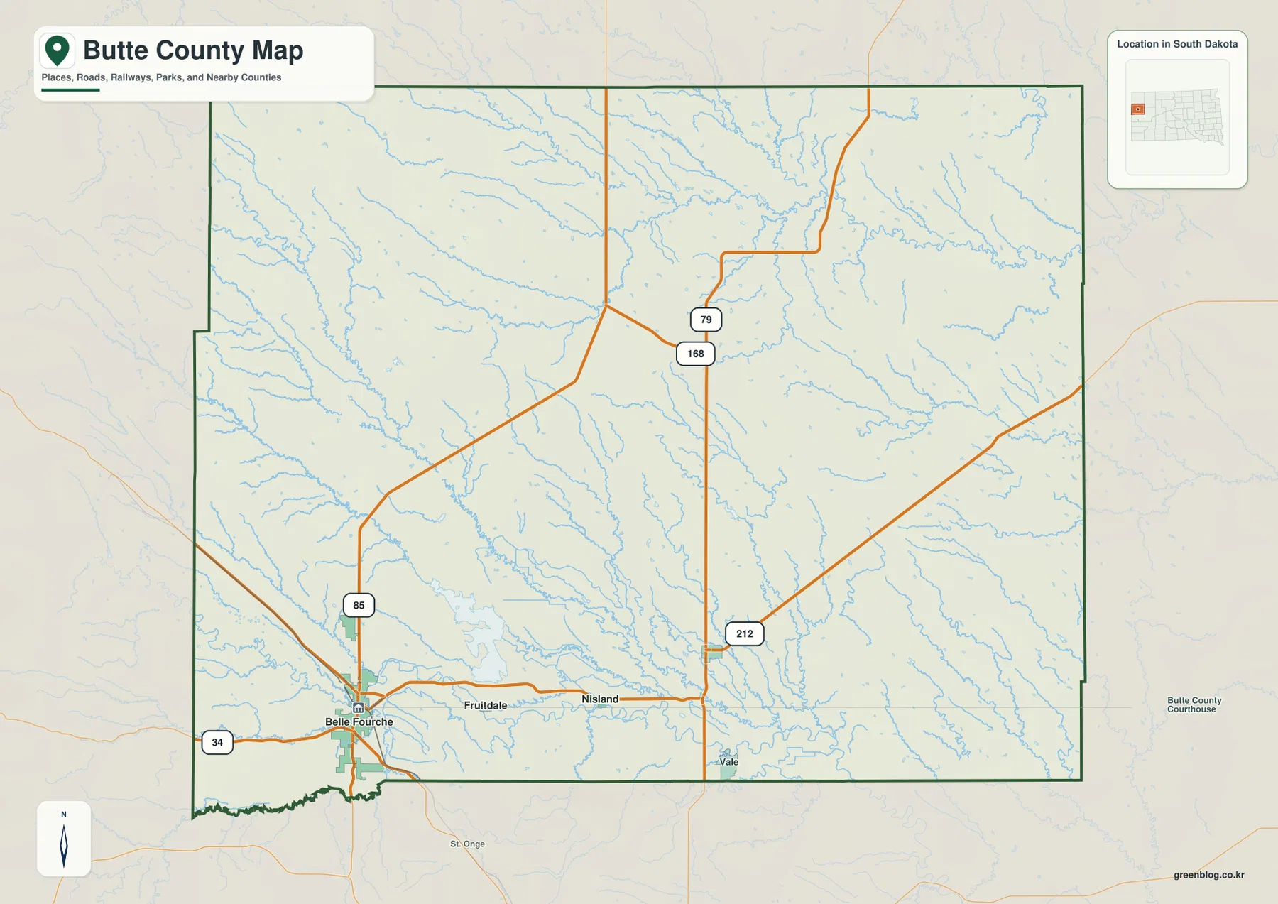
The county outline is broadly rectangular, but the western and southwestern sides are not made of one uninterrupted straight line. Near Belle Fourche, the boundary steps inward and changes direction, which makes the southwest corner easy to recognize. The city-connections view labels Harding County to the north, Lawrence County to the west, and Meade and Perkins counties to the east, giving useful surrounding context without requiring a separate state map.
The Belle Fourche hub diagram separates nearby towns from Newell
The city-connections view uses Belle Fourche as the hub and simplifies the surrounding road detail. Fruitdale is labeled about 8 miles away, Nisland about 15 miles, and Newell about 22 miles. These are straight-line distances, not driving distances, so they should be used to compare relative spacing rather than to predict mileage on a road trip.
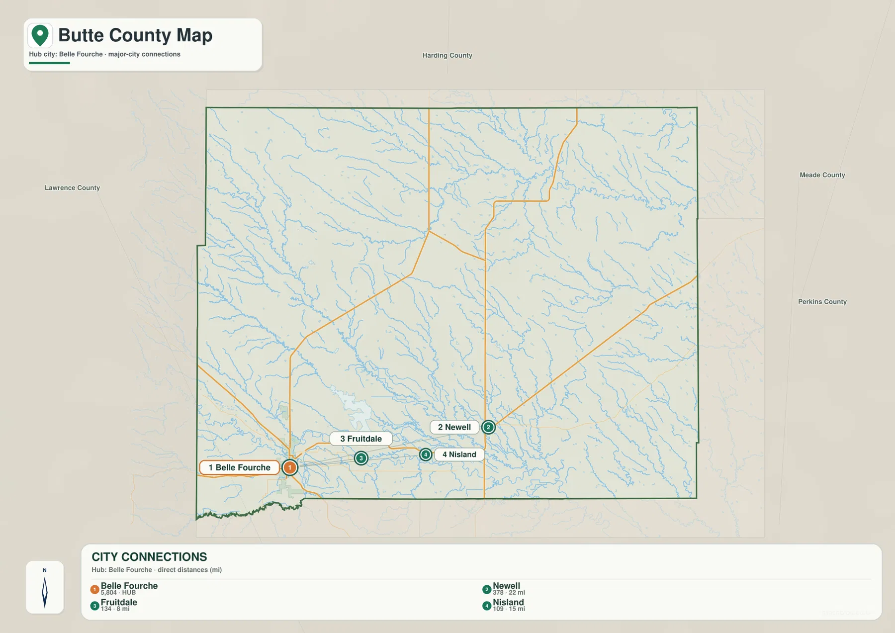
Fruitdale and Nisland sit in the southern portion of the county and are easy to connect visually with Belle Fourche. Newell is farther northeast, so the hub diagram makes its different direction clear even before the general map is consulted. The index printed below the image also lists values beside Belle Fourche, Newell, Fruitdale, and Nisland; this article treats those as values printed in the supplied city index, not as a claim about the latest population estimates.
For practical map reading, the hub image and general county map work best together. The hub view answers the simple distance question, while the county map restores US 85, US 212, SD 34, and the smaller local roads. A reader trying to find Newell can first see that it is the farthest of the three connections from Belle Fourche, then return to the county map to see the road setting around that part of Butte County.
Belle Fourche River and the reservoirs define the southern water network
The terrain-and-water view makes Belle Fourche River the dominant named river in the south. It crosses the southwestern portion of the county and bends eastward, with many smaller creeks joining or running nearby. Owl Creek is labeled to the west, while Redwater River and Hay Creek appear near the southwestern edge. These names help explain why the southern part of Butte County contains far more visible water detail than a road-only map suggests.
Belle Fourche Reservoir is one of the largest labeled water bodies on the map and sits east to northeast of Belle Fourche. Guidinger Reservoir is farther north, while Newell Lake appears deeper in the county interior. The three water bodies are separated enough that they serve as useful landmarks when moving from the road map to the terrain view. This map shows location and names; it does not provide current water level, flood risk, fishing condition, or recreation safety information.
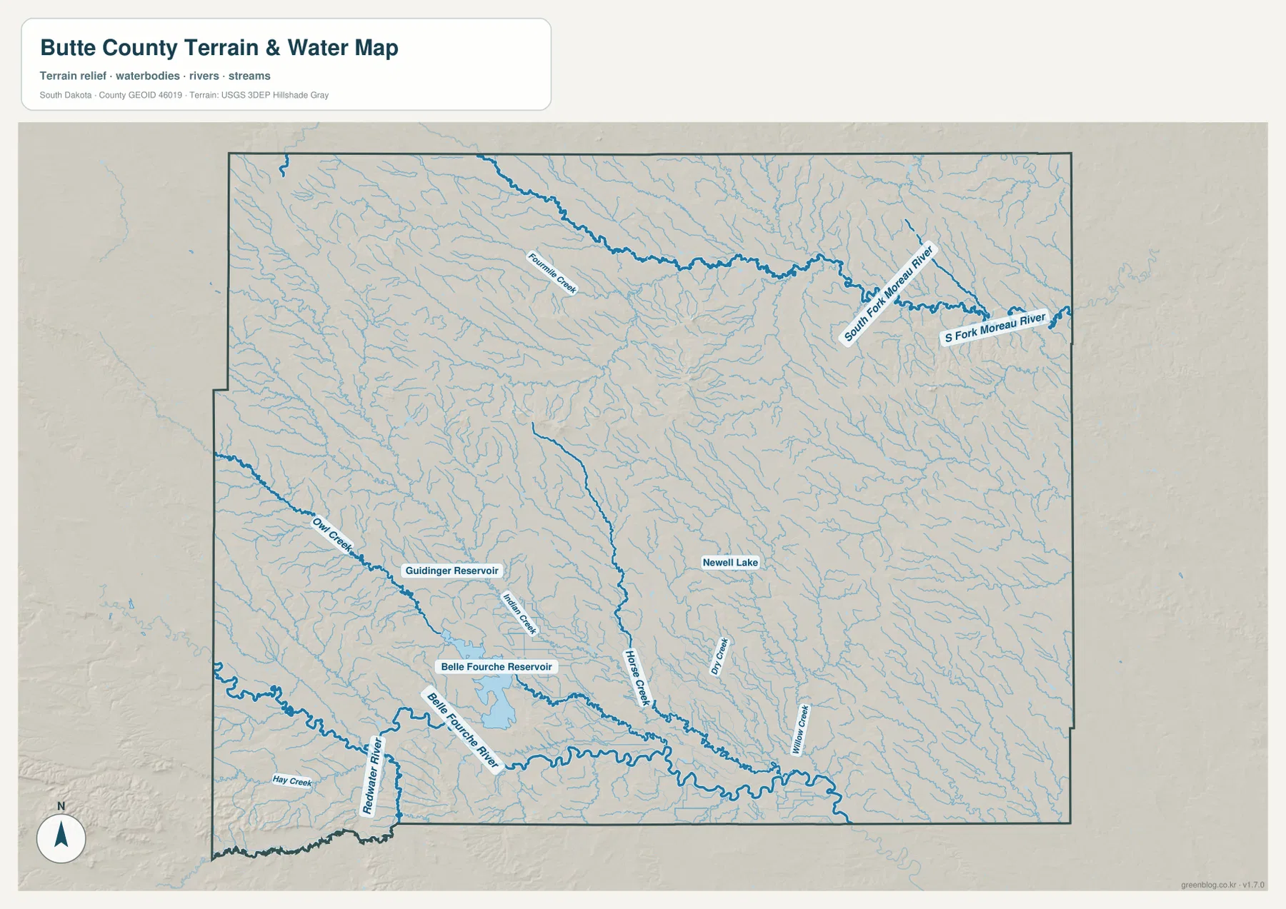
Farther north, Fourmile Creek runs across a broad section of the county, and South Fork Moreau River is labeled in the northeast. The map also shows S Fork Moreau River on the eastern side. Horse Creek extends through the central-southern area, with Dry Creek and Willow Creek farther east. This spread of named streams makes the water map especially useful in the parts of Butte County where communities are sparse.
Around Belle Fourche Reservoir, Indian Creek is labeled north of the reservoir, and Owl Creek approaches from the west. The combination of rivers, creeks, reservoirs, and Newell Lake makes it possible to connect a named place with a nearby water feature without assuming that every blue line has the same size or seasonal behavior. Anyone needing streamflow, water quality, or present reservoir conditions should consult current USGS or South Dakota agency data.
Higher western ground drops toward a broad lower east
The elevation view reports an actual county range of 795 to 1228 meters and a mean of 918 meters. Browns and darker earth tones cover much of the west and southwest, indicating higher ground, while green shades become much more widespread toward the east. A long elevated band is visible in the northwest, and several smaller high features stand out closer to the center of the county.
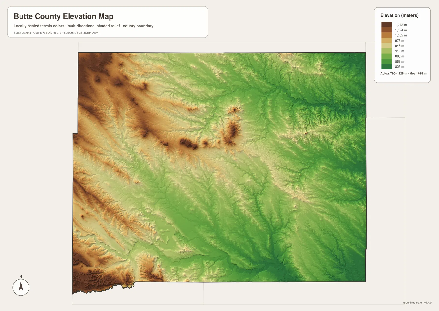
The southwest is particularly interesting because high terrain and the lower Belle Fourche River corridor lie close to one another. The river valley appears lower than nearby uplands, while the far western and southwestern edges contain some of the strongest high-elevation colors. Across the eastern half, the terrain is generally greener and lower, with stream valleys creating additional low lines through the relief.
This elevation surface is designed for county-scale comparison, not parcel or engineering measurement. The 795–1228 meter range is the actual range reported by the supplied elevation map, but the colors generalize the surface so that broad differences are easy to see. A precise elevation for a road point, building, or property should come from detailed USGS 3DEP data or a professional survey.
Following one place across the maps makes the county easier to remember
Belle Fourche is a good example of how the views fit together. On the county map it sits where SD 34 and US 85 meet the southwestern part of the county; on the water map it is close to Belle Fourche River and the large reservoir system; on the elevation view it lies near the transition between higher western terrain and lower river corridors. Looking at the same place in this order produces a clearer picture than reading four unrelated descriptions.
Newell works in a different way. The city-connections image shows it as the farthest of the three labeled connections from Belle Fourche at about 22 straight-line miles, while the water map places Newell Lake in the county interior. In the northeastern part of Butte County, South Fork Moreau River provides another natural landmark away from the Belle Fourche River system. These differences are useful because they show that the county cannot be reduced to one town or one drainage.
If you need roads and community names, begin with the general county map. Use the hub diagram for the straight-line spacing from Belle Fourche, the terrain-and-water map for reservoirs, rivers, and creeks, and the elevation view for the west-to-east relief contrast. The ZIP below contains the same map set as original high-resolution JPG files for printing, classroom work, presentations, or closer inspection. Legal boundaries, parcel work, live travel conditions, flood decisions, and survey-grade elevation require current authoritative data rather than these reference maps alone.
Frequently Asked Questions
Are the 8, 15, and 22 mile labels driving distances from Belle Fourche?
No. The city-connections image labels them as direct distances from the Belle Fourche hub, so they should be read as straight-line distances. Road mileage and travel time will differ according to the route used.
Which map should I use to find Belle Fourche Reservoir and Newell Lake?
Use the terrain-and-water view. It labels Belle Fourche Reservoir, Guidinger Reservoir, Newell Lake, Belle Fourche River, Fourmile Creek, Horse Creek, South Fork Moreau River, and several other streams. It is a location reference, not a current water-level or flood-risk map.
Can the 795–1228 meter range be used as the exact elevation of a property?
No. The range is useful for comparing high and low parts of the county, but the map is generalized at county scale. A location-specific elevation should be checked with detailed USGS 3DEP data or professional survey information.
Map File Information
The Butte County general, city-connections, terrain-and-water, and elevation views are packaged as high-resolution JPG files.
- Included Files: Use only the versions confirmed in the article and supplied images
- File Type: Use the confirmed download contents
- Intended Use: Printing, education, presentations, and map-based projects
Related Maps
Sources and References
The article is based first on the names, roads, water features, and elevation values visible in the supplied Butte County maps. These official sources provide additional county, boundary, hydrography, and elevation reference information.
- Butte County, South Dakota official website
- U.S. Census Bureau QuickFacts – Butte County
- U.S. Census Bureau TIGER/Line Shapefiles
- USGS National Hydrography
- USGS 3D Elevation Program
Green Map creates custom-edited map images using open geographic data sources such as geoBoundaries, Natural Earth, OpenStreetMap, and government open data.
These maps are edited visual materials, not raw data files, and are provided for education, documents, presentations, and graphic reference.