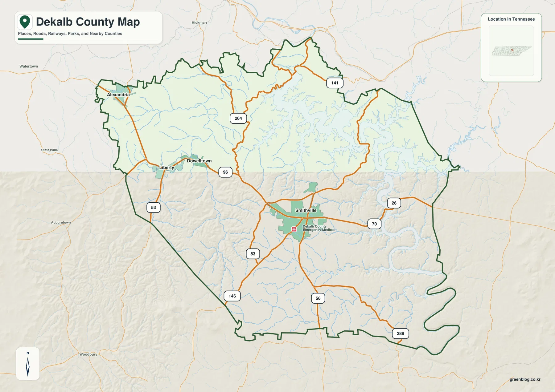
DeKalb County sits in Middle Tennessee, with Smithville near the center of the county and Center Hill Lake occupying a large, irregular section of the east and northeast. This page brings the county boundary, towns, roads, water, and elevation into one place. A ZIP containing four high-resolution A3 JPG maps is also available in the download box below for printing, classroom use, editing, or personal reference.
A useful way to begin is to locate Smithville first. Alexandria lies near the northwestern edge, while Dowelltown and Liberty sit between Alexandria and Smithville. To the east, town labels become less dominant than the winding shoreline of Center Hill Lake, so reading the county from west to east reveals two noticeably different patterns: a town-and-road network in the west and a lake-and-ridge landscape in the east.
Table of Contents
Smithville as the central road and county-seat reference
Smithville is the county seat and the strongest reference point on the general county map. From there, the main roads spread in several directions rather than following a single corridor. US 70 crosses the central part of the county, SR 56 heads south, and SR 83 and SR 146 provide additional links toward the southwest. To the northwest, SR 96 and SR 53 connect the Liberty, Dowelltown, and Alexandria side of the county, while SR 264 and SR 141 reach northward.
The eastern half looks different because road placement is increasingly influenced by the arms of Center Hill Lake and the valleys around them. SR 26 and SR 288 appear on that side of the map, but the shoreline and stream valleys are just as important as the route numbers. A straight line from Smithville toward the eastern boundary can cross several coves or drainage valleys, so the mapped road network gives a more realistic sense of access than simple distance alone.
How Alexandria, Dowelltown, and Liberty relate to Smithville
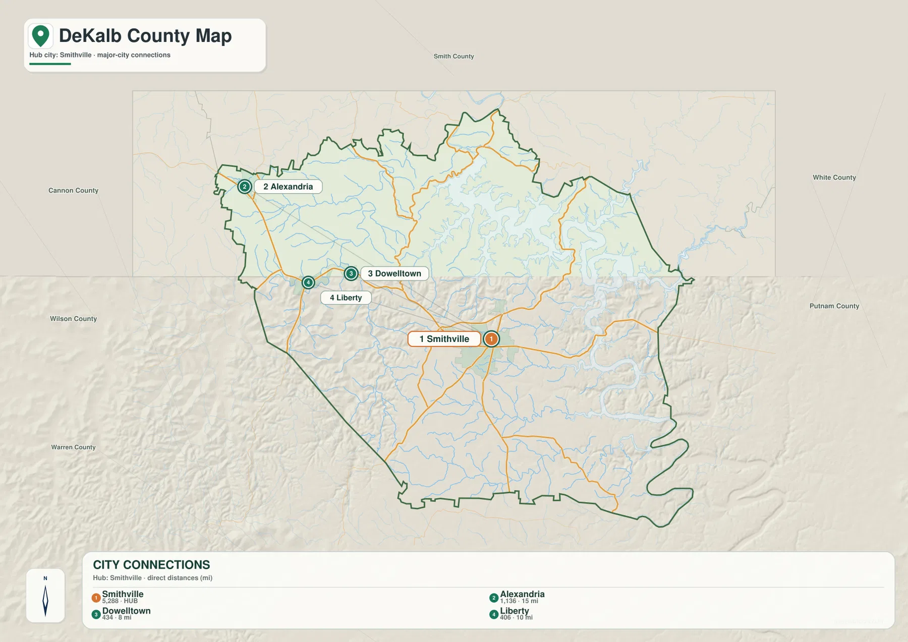
The city-connections map simplifies the settlement pattern. Smithville is shown as the hub, with Alexandria about 15 miles away, Liberty about 10 miles away, and Dowelltown about 8 miles away. Those distances are useful because the three western communities can look close together on a county map even though they occupy different positions along the road network.
Alexandria is closest to the northwestern county edge, making it a useful marker for the Cannon County and Wilson County side of DeKalb County. Dowelltown and Liberty sit farther inside the county and help bridge the map between Alexandria and Smithville. East of Smithville, by contrast, the shoreline of Center Hill Lake becomes the more obvious geographic reference, and fewer large settlement labels appear.
DeKalb County borders Smith, Putnam, White, Warren, Cannon, and Wilson counties. Roads and streams continue across those boundaries, so a label near the edge should be read together with the county outline rather than assumed to belong to DeKalb County simply because it is nearby.
Center Hill Lake and the stream network
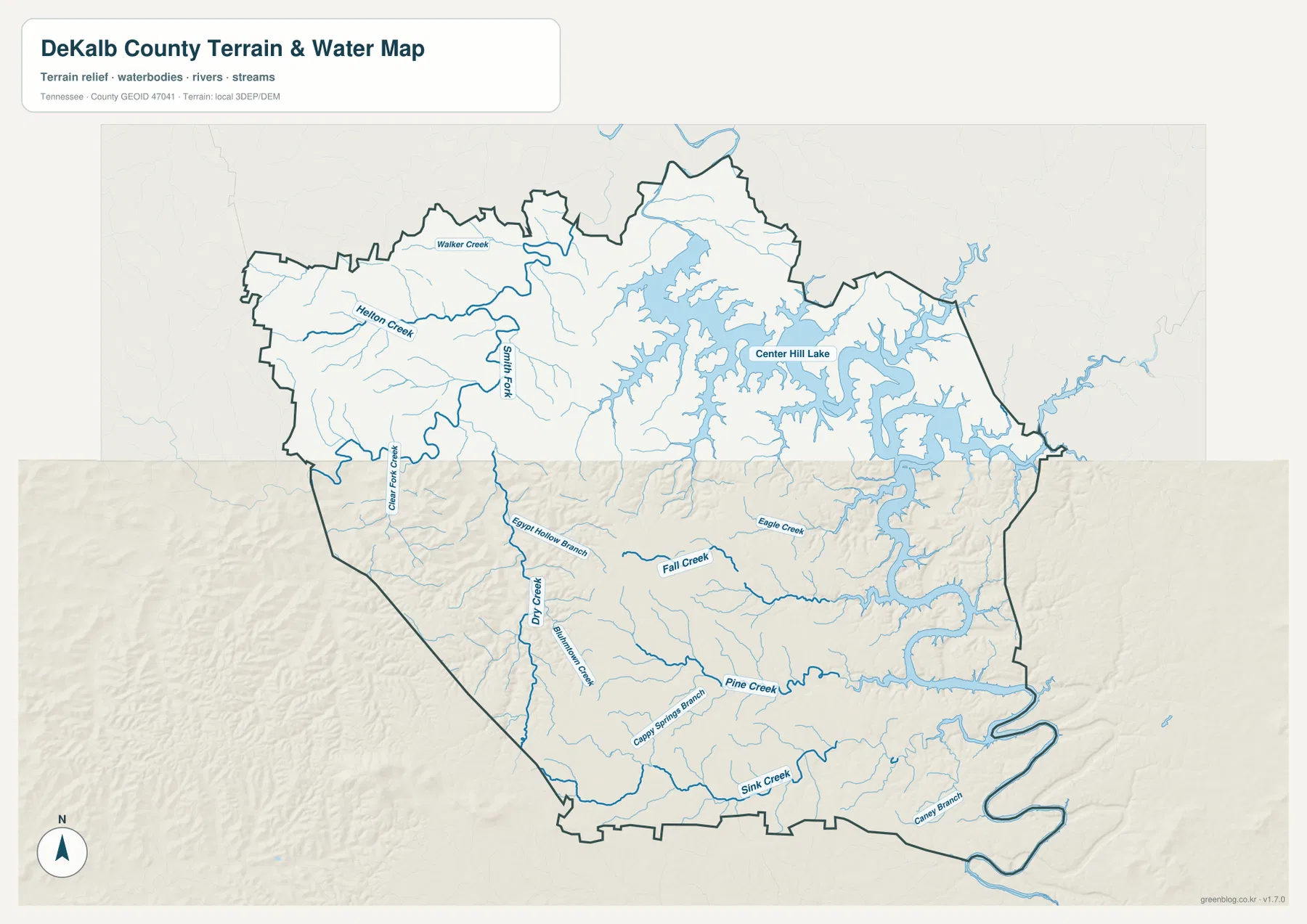
Center Hill Lake is the defining water feature on this set of maps. It spreads across the northeastern and eastern part of DeKalb County with long, branching coves that reach far into the surrounding hills. The shoreline is highly irregular, so places that look close on a small map may be separated by water or by steep ground leading down to the reservoir.
The smaller streams explain much of the interior terrain. Walker Creek and Helton Creek appear in the northwestern area, while Smith Fork runs through the western side. Farther south and east, Fall Creek, Eagle Creek, Pine Creek, Dry Creek, Mountain Creek, and Sink Creek mark separate valleys. These waterways are useful orientation features because they divide the county into a series of ridges and drainage corridors rather than one broad, flat surface.
For boating or fishing, the map is best used to understand the reservoir’s overall location and its relationship to roads and county boundaries. Water levels, launch availability, and access rules can change, so current conditions should be checked with the Tennessee Wildlife Resources Agency or the responsible facility before a trip.
Elevation from lake valleys to higher interior ridges
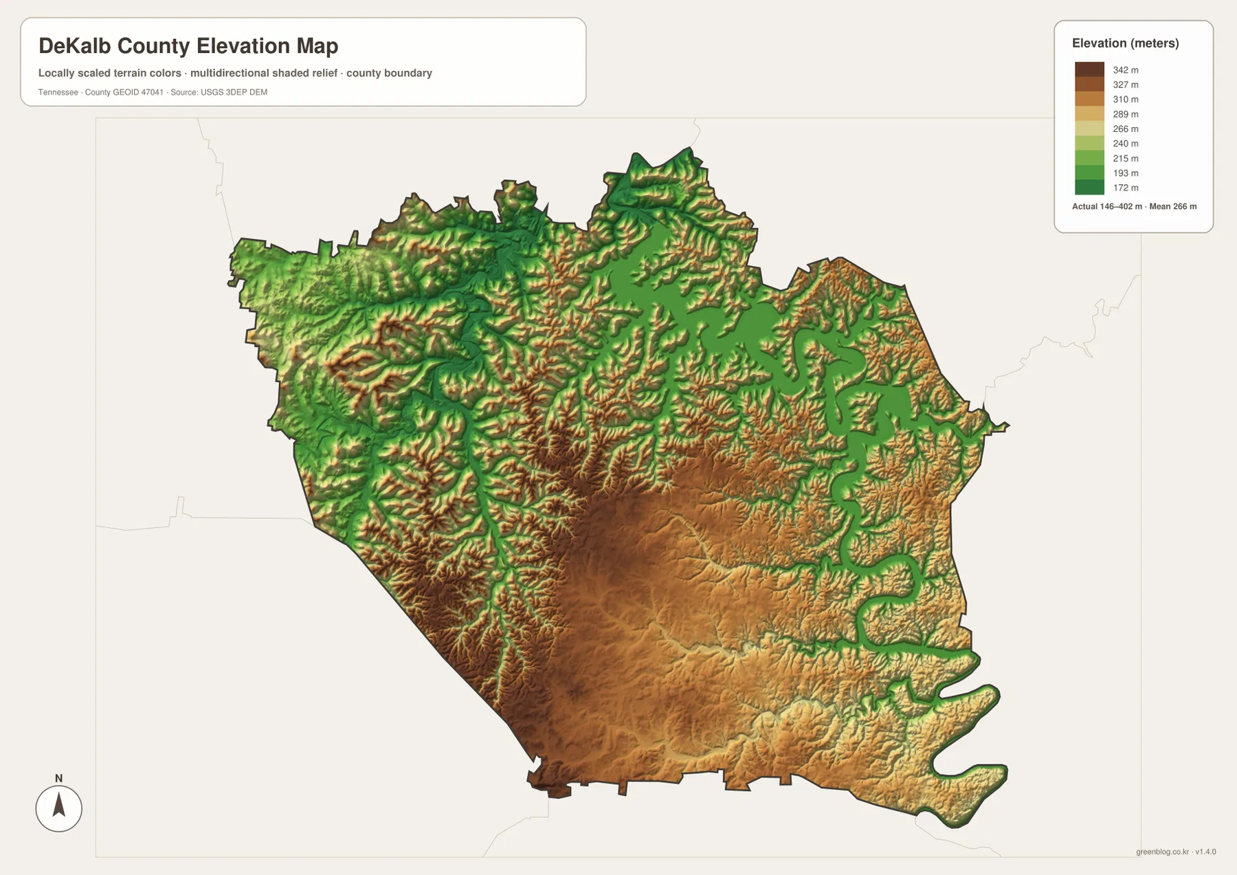
The elevation map reports an actual county range of roughly 146 to 402 meters, with a mean elevation near 266 meters. Lower green areas follow Center Hill Lake and larger stream valleys, while higher brown terrain occupies much of the central, southern, and southwestern interior. The contrast is strong enough to explain why the road pattern bends around ridges and why small streams cut narrow valleys through the county.
Smithville sits within a rolling interior rather than a broad level plain. North and northwest of the city, many narrow ridges and hollows repeat across the map. South and southwest of Smithville, higher ground becomes more continuous, while the eastern reservoir arms create lower, branching corridors that extend deep into the uplands.
This map is intended for county-scale comparison rather than engineering or surveying. It is useful for seeing where land is relatively high or low, but a parcel, trail, construction site, or drainage project requires more detailed elevation data and field verification.
Why roads and water should be read together
Roads alone can make DeKalb County look like a set of lines radiating from Smithville. Adding the lake and streams changes that picture. The western side is easier to understand through town-to-town connections, while the eastern side is shaped by coves, creek valleys, and the reservoir shoreline. That difference is especially important when comparing direct distance with practical driving routes.
For a classroom map or regional presentation, Smithville, Alexandria, Dowelltown, and Liberty work well as settlement anchors. Center Hill Lake and a few named streams then show why the eastern county has a different shape and travel pattern. Adding elevation last makes the relationship between ridges, water, and roads much easier to see without overcrowding the map.
Choosing and downloading the map files
Use the general county map when the main question is boundaries, towns, and major roads. The city map is better for comparing Smithville with the northwestern communities, while the water map makes Center Hill Lake and its feeder streams easier to follow. The elevation map is most helpful when the difference between reservoir valleys and higher uplands matters.
The downloadable JPG files are sized for A3 output and can also be placed in slides, worksheets, reports, or editing software. They are static reference maps, so current road closures, reservoir levels, property lines, and access restrictions should always be checked against the latest official source when those details affect a real-world decision.
Frequently Asked Questions
Where is Smithville compared with Center Hill Lake?
Smithville is near the central part of DeKalb County, while Center Hill Lake occupies much of the east and northeast. US 70 provides a useful first road reference between the central area and the lake side, but the reservoir’s branching coves mean that actual routes are often less direct than the straight-line distance suggests.
How are Alexandria, Dowelltown, and Liberty positioned from Smithville?
All three are northwest of Smithville. The city map shows Alexandria at about 15 miles from the hub, Liberty at about 10 miles, and Dowelltown at about 8 miles. Alexandria lies closest to the northwestern county edge, while Dowelltown and Liberty sit farther inside DeKalb County.
What does the elevation map show about the county?
The actual elevation range is shown as about 146 to 402 meters, with a mean near 266 meters. The lowest areas generally follow Center Hill Lake and major stream valleys, while higher terrain is more common through the central, southern, and southwestern parts of the county.
Map File Information
The ZIP contains high-resolution A3 JPG versions of the county, city, water, and elevation maps for DeKalb County, Tennessee.
- Included Files: County, city, water, and elevation maps
Related Maps
Sources and references
County boundaries and basic road geography can be checked against the U.S. Census Bureau TIGER/Line files. Population and area context is available through U.S. Census Bureau QuickFacts and the Census Gazetteer files.
For current fishing and reservoir-use information, see the Tennessee Wildlife Resources Agency Center Hill Reservoir page. Historical county background is available from the Tennessee State Library and Archives DeKalb County fact sheet.
Additional water and elevation references include USGS National Hydrography and the USGS 3D Elevation Program.
Green Map creates custom-edited map images using open geographic data sources such as geoBoundaries, Natural Earth, OpenStreetMap, and government open data. These maps are edited visual materials, not raw data files, and are provided for education, documents, presentations, and graphic reference.