A Putnam County Florida Map becomes much easier to understand once you use Palatka and the St. Johns River as the main reference points. Putnam County lies inland in northeastern Florida, and Palatka sits on the west bank of the broad St. Johns River. From there, the map spreads west toward Interlachen and south toward Pomona Park, Crescent City, and Welaka, with highways, lakes, and streams explaining why these communities follow different routes even when they appear fairly close together.
This page includes a county reference map with roads and boundaries, a city-connections map centered on Palatka, and a terrain-and-water map that emphasizes the St. Johns River and the county’s many inland waters. The same three map views are also available below as a downloadable ZIP containing high-resolution A3 JPG files. They are designed for countywide orientation, printing, study, and regional comparison rather than parcel research, turn-by-turn navigation, or engineering measurements.
Table of Contents
Palatka as the Road and River Reference Point
On the county map, Palatka immediately stands out as the place where several important routes meet. SR 20 crosses the county from the Interlachen side in the west toward Palatka and East Palatka. US 17 provides the clearest north–south line on the eastern side of the county and continues south toward Pomona Park and Crescent City. SR 19 leaves the Palatka area toward the southwest, SR 100 heads east, and SR 207 branches toward the northeast. This fan of roads makes Palatka a practical starting point for finding nearly every other labeled place.
The boundary outline also places Putnam County in context with its neighbors. Clay and St. Johns counties lie along the northern side, Flagler is to the east, and Volusia is to the southeast. Marion and Alachua counties border the west and southwest, while Bradford lies to the northwest. Although Putnam is part of northeastern Florida and is not far from Atlantic coastal counties, it does not have an ocean shoreline of its own. Its geography is shaped much more strongly by the St. Johns River and a dense scattering of inland lakes and creeks.
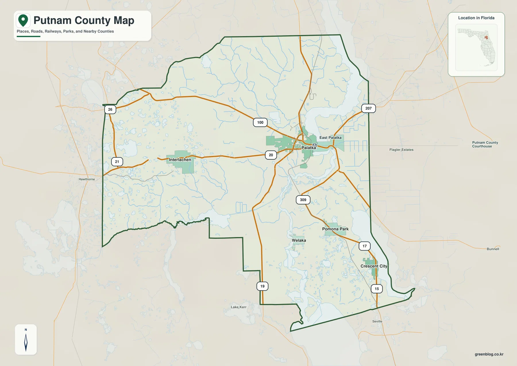
Interlachen provides a useful western reference because SR 20 links it directly with Palatka. Around Interlachen, the background is filled with many small lakes, giving the western part of the county a different appearance from the broad-river landscape near Palatka. Farther south, Pomona Park and Crescent City line up closer to the US 17 corridor. Welaka sits farther east near the St. Johns River, so it should not be treated as another stop on the same highway line simply because it is also in southern Putnam County.
How the Main Communities Sit Around Palatka
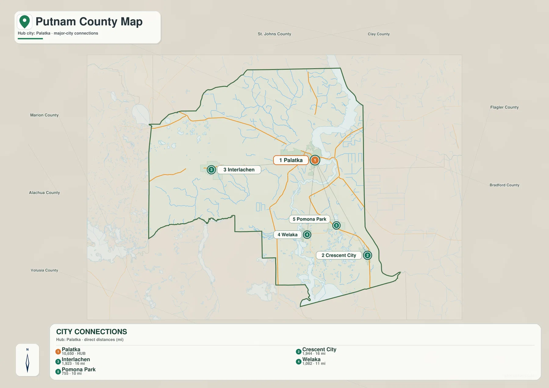
The city-connections view removes much of the extra detail and uses Palatka as the hub. Interlachen is shown to the west, Pomona Park and Crescent City to the south, and Welaka to the southeast near the river. The labels at the bottom include population figures and direct distances from Palatka. Those distance values are straight-line distances, not road mileage, so they are useful for comparing relative spacing but should not be used to estimate driving time.
Interlachen and Crescent City are each labeled at about 16 miles from Palatka in a straight line, yet they lie in almost opposite directions and are reached by different road systems. Pomona Park is shown at about 10 miles from Palatka, while Welaka is about 11 miles away. The map therefore highlights an important feature of Putnam County: similar geographic distance does not mean similar access. Lakes, the St. Johns River, and the direction of the main highways all affect how a traveler would actually move between these places.
The pattern also shows how settlement is distributed rather than concentrated in one continuous urban area. Palatka is the administrative and transportation center in the northeast, while the other incorporated communities are separated by broad stretches of lower-density land and water. This is why a city-only list can be misleading. Looking at the road and water maps alongside the connection graphic explains the spaces between the communities and makes the different travel corridors much easier to understand.
The St. Johns River and Putnam County’s Creek Network
The St. Johns River is the dominant natural feature on the water map. It forms a broad north–south presence along the eastern side of Putnam County and passes directly by Palatka. Its width is visually distinct from the smaller creeks, which helps explain why road crossings and communities on opposite banks need to be read carefully. East Palatka may look close to downtown Palatka, for example, but the river is a substantial physical feature between the two sides.
Several named tributaries are visible farther inland. Rice Creek, Etoniah Creek, and Simms Creek appear in the northern half, while Deep Creek and Sweetwater Creek help define the central and western drainage pattern. The western side is also dotted with many small lakes. Taken together, these features show that Putnam County is not simply a flat road grid around Palatka; water repeatedly interrupts and reshapes the spaces between roads and settlements.
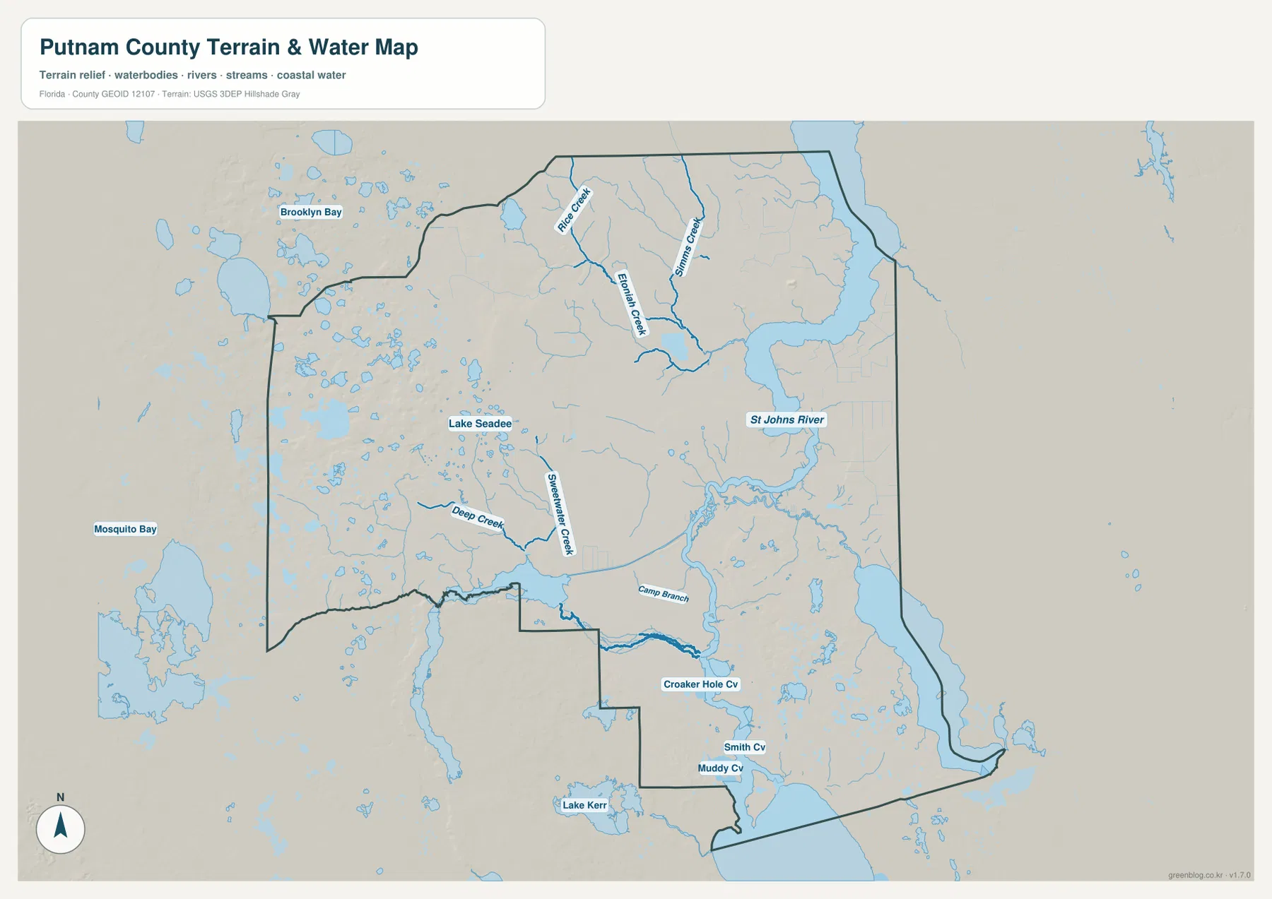
Lake Kerr appears toward the southern part of the water view, and the surrounding area contains numerous other lakes and wet areas. The current source material also identifies Crescent Lake in southeastern Putnam County and notes that Dunns Creek connects it with the St. Johns River. That distinction matters when locating Crescent City: the community is associated with the Crescent Lake side of the county rather than sitting directly on the main St. Johns channel. Welaka, by contrast, is much more closely tied to the river itself.
This is a regional water-reference map, not a flood-zone or boating chart. It does not establish legal water boundaries, safe navigation routes, water depth, parcel access, or current flood risk. For those questions, the county GIS and current water-management resources listed below are more appropriate. The map’s strength is simpler: it shows how the river, creeks, and lake-rich interior fit together at the same county scale as the roads and communities.
Match the Map to the Question You Are Asking
Start with the county map when you need the broadest orientation. It combines the county outline, nearby counties, the main communities, and the most visible highways in one view. Find Palatka first, then follow SR 20 west toward Interlachen or US 17 south toward Pomona Park and Crescent City. That sequence is especially helpful for someone who knows a town name but does not yet know which side of the county it occupies.
Use the city-connections map when relative spacing matters more than road detail. Its simplified hub layout makes it easy to see that Interlachen is west of Palatka while Crescent City and Pomona Park are to the south and Welaka is southeast toward the river. Remember that the distance numbers are straight-line measurements. If the goal is a trip plan, use the city map only to understand direction and then confirm actual road mileage with a current routing service.
The water map is the better choice for questions about why the county’s settlement pattern looks the way it does. The St. Johns River dominates the east, smaller creeks cross the interior, and lakes are especially common across the western and southern sections. Switching between the road map and the water view can clarify why two places that appear close on a county outline may require different approaches or may belong to different local corridors.
Small Details That Change How You Read Putnam County
One detail worth noticing is the relationship between Palatka and East Palatka. The two names sit close together, but the St. Johns River is the major feature between them. When you compare the county and water maps, the route pattern around the crossing becomes clearer: SR 20 provides an east–west connection, while SR 100 and SR 207 continue away from the eastern side in different directions. Reading the river first prevents the road lines from looking like a simple uninterrupted grid.
Southern Putnam County has a similar issue. Pomona Park and Crescent City align more naturally with US 17, while Welaka belongs to the St. Johns River side of the county. Their straight-line spacing can look small on the city map, but the water map explains why that does not create one simple road corridor. This distinction is useful for regional study, route planning at a broad level, and understanding why community connections in a lake-rich county do not always follow the shortest visual line.
The maps are intentionally generalized. Major routes, representative communities, county context, and the largest or most useful water features are emphasized, while local streets and fine property details are reduced or omitted. For classroom work, printed handouts, presentations, or first-stage trip research, that simplification keeps the county readable. For an address, parcel, development decision, flood question, or current construction detour, use a current official source after you have used this page to establish the larger geographic setting.
Frequently Asked Questions
What is the best place to use as a reference point on a Putnam County map?
Palatka is the most useful starting point. It is the county seat, sits on the west side of the St. Johns River, and is surrounded by the county’s most important road junctions. Once Palatka is located, Interlachen, Crescent City, Pomona Park, Welaka, and the main highway directions are much easier to place.
Are the distances on the city-connections map driving distances?
No. They are straight-line distances from Palatka. Interlachen and Crescent City are both shown at roughly 16 miles from the hub, but they lie in different directions and use different road corridors, so real driving distances can be longer and should be checked separately.
Why should Welaka and Crescent City be read as different southern corridors?
Crescent City is associated with the US 17 and Crescent Lake side of southern Putnam County, while Welaka lies farther east near the St. Johns River. Lakes, creeks, and different approach roads separate the two patterns, so their closeness on a county-scale view does not mean they sit on the same direct highway route.
Map File Information
Download the Putnam County reference map, city-connections map, and water map as high-resolution A3 JPG files in one ZIP archive.
- Included Versions: county map, city-connections map, water map
- Included Files: 3 high-resolution A3 JPG maps
Related Maps
- Arcadia Roads and Peace River | DeSoto County Florida Map
- Baker County Florida Map
- Between the Aucilla and Withlacoochee: Madison County Florida Map
Sources and References
- Putnam County Geographic Information Services – official county GIS information for more detailed and current local reference.
- Florida Department of Transportation: County General Highway Maps – official statewide county road-map resources.
- St. Johns River Water Management District: Water in Florida – background on the river basin and Florida water resources.
- U.S. Census Bureau: Putnam County QuickFacts – county population and basic statistical reference.
Green Map creates custom-edited map images using open geographic data sources such as geoBoundaries, Natural Earth, OpenStreetMap, and government open data.
These maps are edited visual materials, not raw data files, and are provided for education, documents, presentations, and graphic reference.