A Santa Rosa County Map makes more sense when the county is read from north to south rather than as a single compact area. Jay sits near the Alabama state line, Milton and Pace occupy the central transportation belt, and Navarre and Gulf Breeze lie much farther south among bays, sounds, and peninsulas. Forest and stream networks dominate much of the northern half, while broad coastal water bodies shape the road pattern and settlement geography near the Gulf side.
This page combines three views of the same county. The first shows boundaries, roads, and place names; the second compares Milton with Jay and Gulf Breeze using straight-line distances; and the third emphasizes rivers, creeks, bays, and coastal water. The same three maps are also available in a ZIP containing three high-resolution A3 JPG files, so visitors who need a printable reference can download them after reviewing the details below.
Table of Contents
Milton anchors the road network in a long north-south county
Milton is the easiest place to use as an orientation point on the general county map. It is the county seat and lies a little south of the geographic middle of Santa Rosa County, close to the central east-west transportation belt. Pace appears just to the west, while East Milton and Harold extend the settled corridor toward the east. U.S. 90 and I-10 cross this part of the county, helping connect the inland communities with neighboring Escambia and Okaloosa counties.
North of Milton, the labels spread farther apart. Allentown, Chumuckla, New York, Wallace, Springhill, and Munson appear among large stretches of forest and a dense network of small streams. Jay is near the northwestern edge close to the Alabama line. This part of Santa Rosa County looks very different from the coastal south: roads are less concentrated, settlement labels are more widely separated, and watercourses thread through a broad rural landscape.
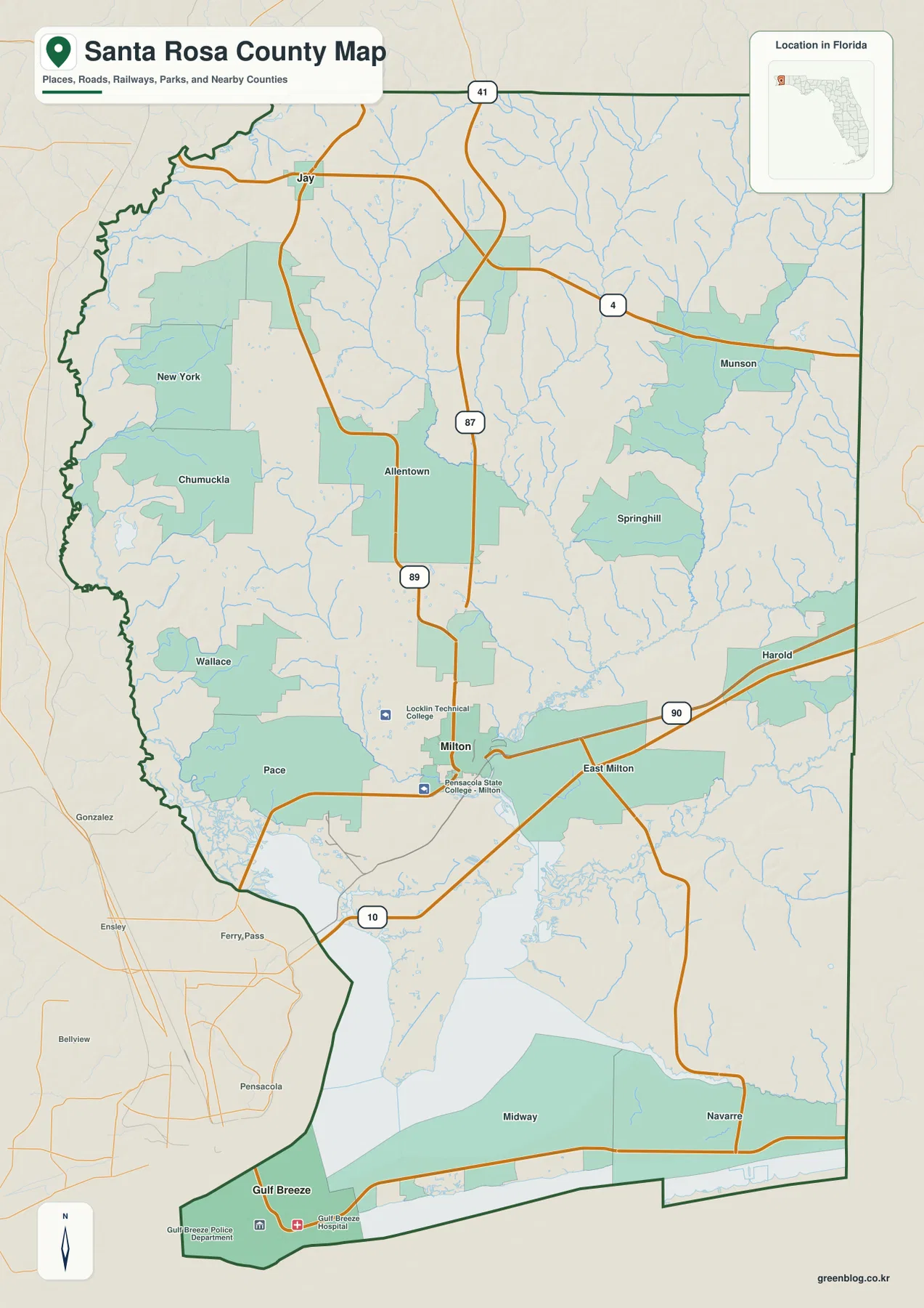
The southern section narrows into a geography controlled by bays and coastal corridors. Midway and Navarre sit along the U.S. 98 side of the county, while Gulf Breeze occupies the southwestern peninsula near the entrance to Pensacola Bay. A destination may look close to Milton on a small map but still require a longer road approach because East Bay, Pensacola Bay, and the connecting waterways interrupt a simple north-south path. State Road 87 provides a direct inland-to-Navarre orientation, while the State Road 281/Garcon Point route provides another way to connect the central area with the U.S. 98 corridor.
The county-frame context is also useful. Escambia County lies along the western side, Okaloosa County is to the east, and Alabama is immediately north of the county line. To the south, the map transitions into Pensacola Bay, Santa Rosa Sound, and the barrier-island coast. That combination explains why Santa Rosa County can feel like several different landscapes joined into one jurisdiction: inland forest, a central highway belt, bayfront peninsulas, and Gulf-side communities all occur within the same county boundary.
Jay and Gulf Breeze sit in opposite directions from Milton
The city-connections map deliberately removes most small place names and focuses on three incorporated municipalities. Milton is the hub. Jay is plotted to the north, while Gulf Breeze appears to the southwest near the coastal end of the county. The map lists Gulf Breeze at about 19 miles from Milton and Jay at about 23 miles. Those figures are straight-line distances between mapped points, not driving distances measured along highways.
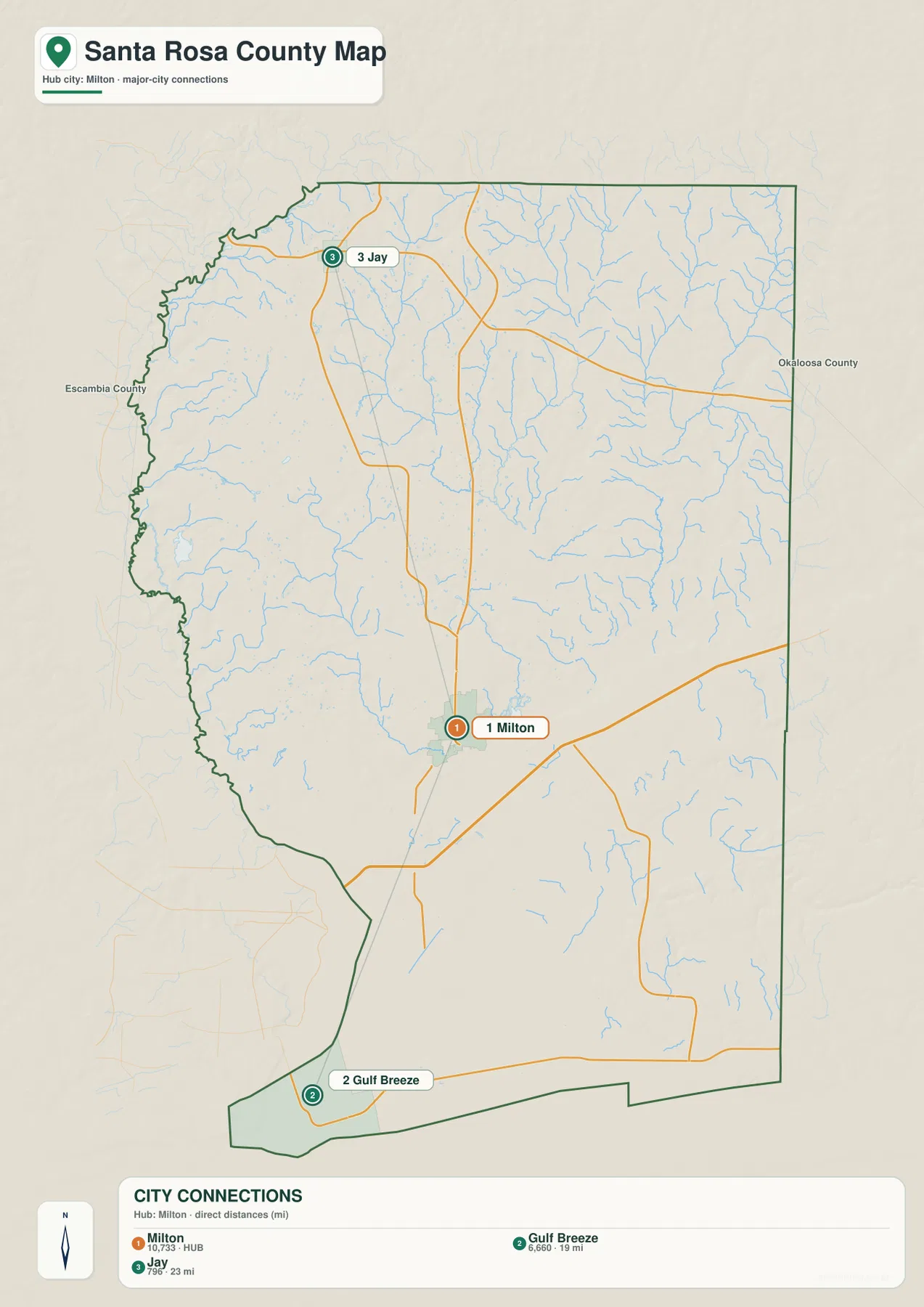
The similarity of the two distance numbers can be misleading if the surrounding geography is ignored. The route toward Jay stays inland through the northern half of the county, where forests and stream valleys are the main physical features. Gulf Breeze lies in a very different setting near large bays and bridge crossings. A straight segment between Milton and Gulf Breeze passes across water and land that a vehicle cannot follow directly, so the real road distance and travel time are necessarily different from the number printed on the connector map.
The map also highlights an important distinction between settlement size and municipal status. Milton, Gulf Breeze, and Jay are incorporated municipalities. Pace and Navarre are not incorporated cities, even though both are prominent communities on the general county map and are important parts of the county’s population pattern. That is why a city-connection graphic can look surprisingly sparse compared with the general map. The two views answer different questions: one shows the legal municipalities selected for comparison, while the other shows the broader set of places residents actually use to orient themselves.
Navarre is especially useful as a southern reference even though it is not one of the three city markers. On the general map, State Road 87 leads south from the Milton side toward Navarre, while Gulf Breeze lies farther west along the U.S. 98 corridor. Treating the whole southern coast as a single destination can therefore hide an important difference. Navarre and Gulf Breeze are both coastal-side communities, but they are reached from the central county by different road approaches and sit on different parts of the bay-and-sound system.
Blackwater River connects an inland stream network with the bays
The terrain-and-water map shifts attention away from roads and toward drainage. Blackwater River is the clearest central feature. It runs through the middle portion of the county and reaches Blackwater Bay south of the Milton area. From there, the water system opens into the much broader East Bay. Looking at this map beside the road map helps explain why Milton developed where an inland route and a major river corridor meet.
The northern half is filled with smaller named waterways. West Fork Big Coldwater Creek runs through the north-central part of the map, while Big Juniper Creek and Sweetwater Creek appear farther east. Bear Lake and McLellan Bay are labeled in the northeastern area. Harris Bay and Pond Creek are visible closer to the western side, and White River appears in the southwest before the landscape opens into the larger bay system. Near the north edge, the map also labels the Conecuh River along the broader drainage setting.
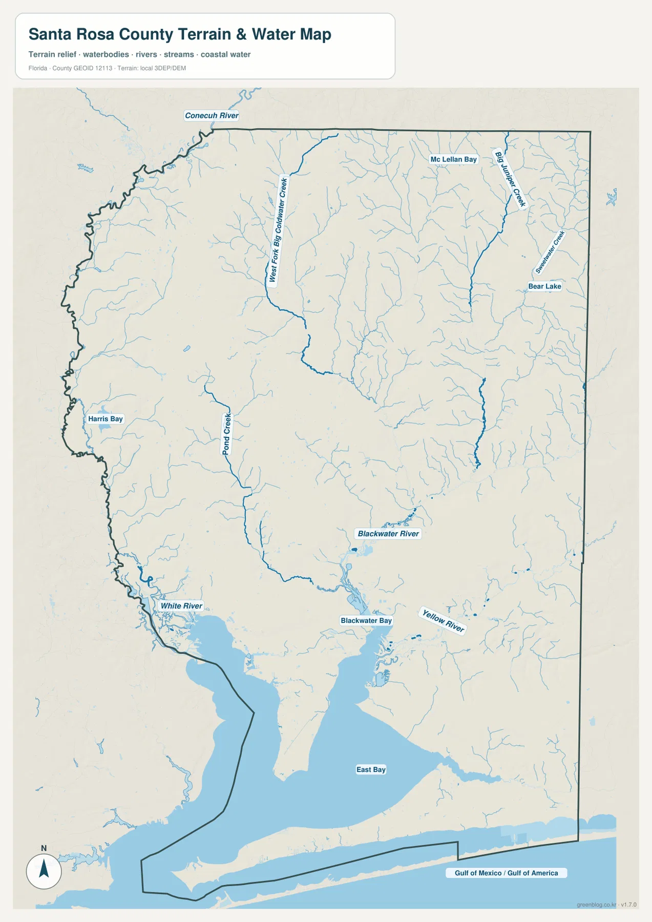
South of Blackwater Bay, the scale of the water features changes dramatically. East Bay occupies a broad area, and the county’s southern edge reaches the long barrier-island and sound system. Gulf Breeze lies on the western peninsula close to Pensacola Bay, while Navarre is farther east along the mainland side of Santa Rosa Sound. Navarre Beach is separated from mainland Navarre by the sound, so the two names represent connected communities in everyday use but different physical locations on the map.
Putting all three views together reveals a strong north-to-south contrast. The northern county is mostly an inland landscape cut by many creeks, the Milton area is organized around the Blackwater River and the main road belt, and the southern county is broken up by large bays and coastal water. This is why road lines that look simple on the general map sometimes bend, spread apart, or converge on a bridge corridor. Water is not just a background symbol here; it is one of the main reasons the settlement and transportation pattern looks the way it does.
The water map is a reference map for the relative location of rivers, streams, lakes, bays, and coastal water. It is not a flood-zone map, parcel map, legal shoreline survey, depth chart, or navigation product. Anyone making a property, insurance, boating, engineering, or emergency-planning decision should use the latest official data for that purpose. For general county orientation, however, this simplified view makes the relationship between Milton, Blackwater River, East Bay, and the coastal communities much easier to see.
A practical way to use the set is to begin with the county map, locate Milton and the principal highways, then switch to the city map to compare Jay and Gulf Breeze in opposite directions. Finish with the water map to see what lies between those places. That sequence explains why two communities with similar straight-line distances from Milton can have very different travel patterns, and why Navarre’s position makes more sense when U.S. 98, State Road 87, East Bay, and Santa Rosa Sound are viewed together.
Frequently Asked Questions
Why is Milton the best starting point for reading the Santa Rosa County map?
Milton is the county seat and sits close to the central road belt where U.S. 90 and I-10 cross the county. It also provides a useful reference for State Road 87 toward the north and Navarre side. Once Milton is located, Pace, Jay, Navarre, Gulf Breeze, and the major water features are easier to place in relation to one another.
Are the 19-mile and 23-mile city-map distances driving distances?
No. The city-connections map shows straight-line distances from Milton to Gulf Breeze and Jay. Roads must follow land, bridge crossings, and established highway corridors, so actual driving distances and travel times can be longer. Use current road or navigation information when planning a trip.
Can the Blackwater River and East Bay map be used to determine flood risk?
No. The terrain-and-water map is intended to show the relative positions of rivers, creeks, bays, lakes, and coastal water. It does not show official flood zones or parcel-level risk. For flood insurance, building, emergency planning, or property decisions, consult the latest FEMA and Santa Rosa County mapping resources.
Map File Information
The Santa Rosa County boundary-and-road map, city-connections map, and terrain-and-water map are available as high-resolution A3 JPG files.
- Included Versions: county map, city map, water map
- Included Files: 3 high-resolution A3 JPG maps
Related Maps
- Arcadia Roads and Peace River | DeSoto County Florida Map
- Baker County Florida Map
- Between the Aucilla and Withlacoochee: Madison County Florida Map
Sources
County statistics can be checked through the U.S. Census Bureau QuickFacts page for Santa Rosa County. For additional highway context, see the Florida Department of Transportation county highway maps. Northern forest and river context is available from the Florida Forest Service page for Blackwater River State Forest, while the coastal barrier-island setting can be explored through the National Park Service Gulf Islands National Seashore maps.
Green Map creates custom-edited map images using open geographic data sources such as geoBoundaries, Natural Earth, OpenStreetMap, and government open data.
These maps are edited visual materials, not raw data files, and are provided for education, documents, presentations, and graphic reference.