Download the Marshall County Alabama Map as a four-file A3 JPG ZIP, with separate county, city, terrain-and-water, and elevation sheets. Together they make the geography around Lake Guntersville much easier to understand than a county outline alone. The lake occupies a large internal space, while Albertville and Boaz sit on higher ground to the southeast and Arab lies on the western uplands.
The maps are designed for readers who need a clear location reference rather than a technical GIS product. You can use them to place Guntersville, Albertville, Boaz, Arab, Grant, and Douglas; follow the main highways; compare the Tennessee River and reservoir with smaller streams; and see how elevation changes from the lake lowlands to surrounding ridges. A ZIP containing four high-resolution A3 JPG files is provided after the map sections.
Table of Contents
County roads and places around Lake Guntersville
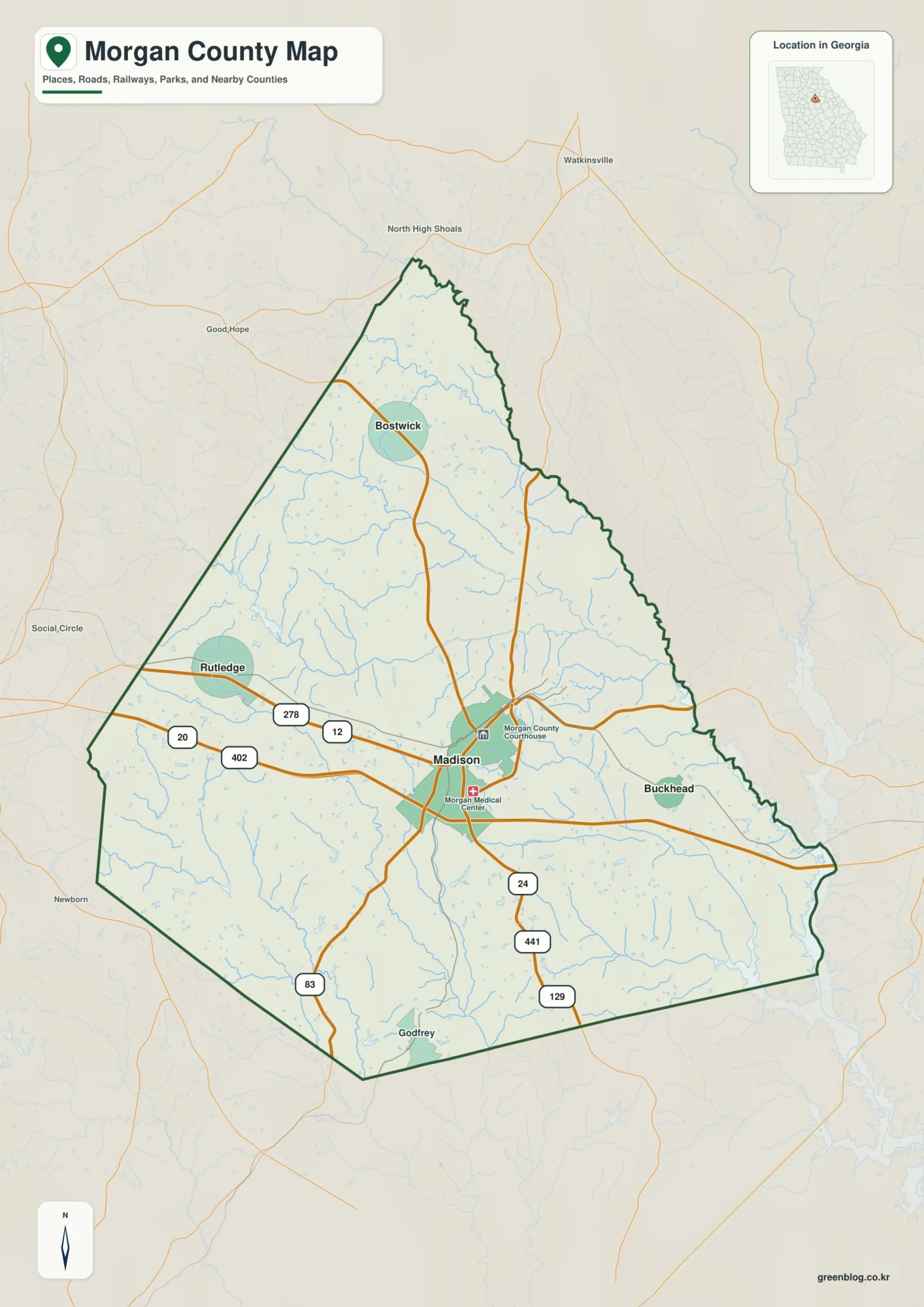
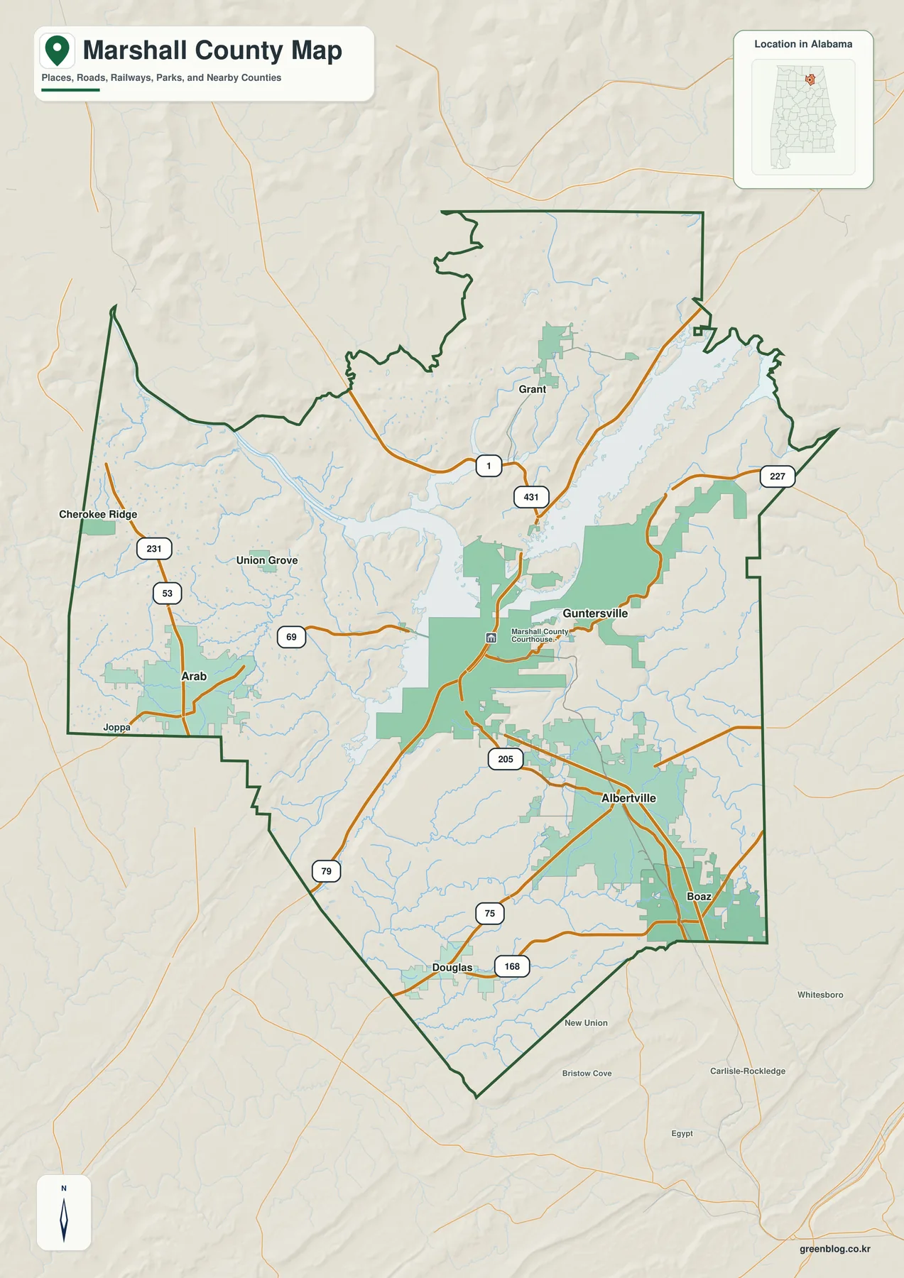
The general county map puts Lake Guntersville near the center of the page and shows how the main communities sit around it. Guntersville is on the lake-facing side of the county, while Albertville and Boaz are clustered farther southeast. Arab is separated to the west, Grant is north of the main lake crossing, and Douglas sits close to the southern edge. Cherokee Ridge, Union Grove, and Joppa provide additional reference points on the western side.
Road placement is just as useful as the city labels. U.S. 431 connects the Guntersville area with Albertville and Boaz, making it the clearest route between the lakefront county seat and the Sand Mountain cities. U.S. 231 crosses the western side through Arab. Alabama 69 links the Arab side toward Guntersville, while routes 75, 79, 168, 205, and 227 add local connections around the highlands and reservoir.
| State | Alabama |
|---|---|
| County | Marshall County |
| County seat | Guntersville |
| Major cities shown | Albertville, Boaz, Guntersville, Arab |
| Main routes | U.S. 431, U.S. 231, Alabama 69, 75, 79 |
| Major water features | Lake Guntersville, Tennessee River, Paint Rock River |
| Elevation shown | About 155–421 m; map mean about 270 m |
The supplied county material identifies Guntersville as the county seat, but Marshall County also has a long-standing courthouse presence in Albertville. That arrangement helps explain why the two cities both appear important on a county map even though they occupy different physical settings. Guntersville is closely tied to the reservoir and Tennessee River, whereas Albertville serves the higher Sand Mountain side of the county.
Six major cities and the county’s divided settlement pattern
The city-distribution map ranks six major places and prints the values used in its index: Albertville 22,813; Boaz 10,814; Guntersville 8,916; Arab 8,679; Grant 1,336; and Douglas 1,113. The image does not state the reference year for those figures, so they are best treated as the map package’s ranking values rather than as a claim about the latest official population. Their real value here is showing relative size and geographic separation.
Albertville and Boaz form the most obvious pair. They are close together in the southeastern part of the county, both on the higher Sand Mountain side. Guntersville is farther northwest at the reservoir, and Arab is well to the west on Brindlee Mountain. Grant and Douglas extend the distribution north and south, so the six labels cover much of the county rather than clustering around one downtown.
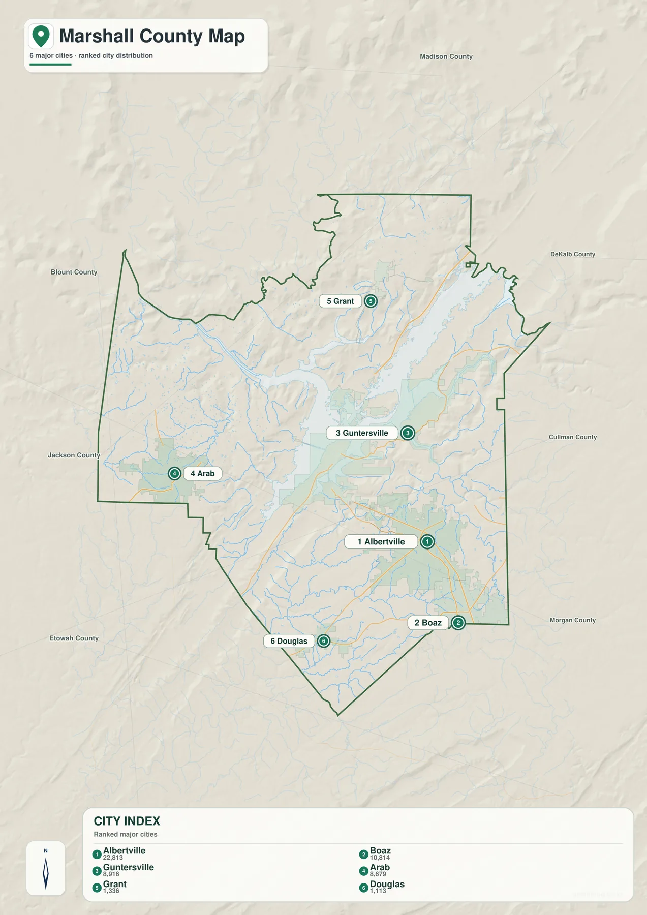
This layout is useful when planning a regional reference sheet. If the goal is to show the largest urban concentration, Albertville and Boaz deserve to be read together. If the goal is county government or reservoir access, Guntersville becomes the key reference. Arab makes more sense as a western center connected to U.S. 231, while Grant and Douglas help orient the less urban northern and southern edges.
The map therefore describes a county with several centers rather than one dominant core. Highways and terrain help keep these centers distinct. The lake separates some road movements, and the transition from river-level land to upland plateaus changes how the communities relate to one another even when straight-line distances are modest.
Lake Guntersville, the Tennessee River, and smaller waterways
The terrain-and-water map makes the reservoir the dominant feature. Lake Guntersville stretches through the middle and northeastern part of the county, while the Tennessee River and Wheeler Lake are labeled toward the west. Paint Rock River is shown near the northwestern water network. This broad water system explains why the county road pattern cannot be understood as a simple grid.
The earlier county material, citing TVA information, describes Guntersville Reservoir as having about 67,900 acres of water surface and roughly 890 miles of shoreline. The reservoir continues beyond Marshall County, so the shoreline should not be mistaken for the county boundary. It is also important to treat this map as a geographic reference: it does not show parcel ownership, legal water boundaries, flood zones, or navigation hazards.
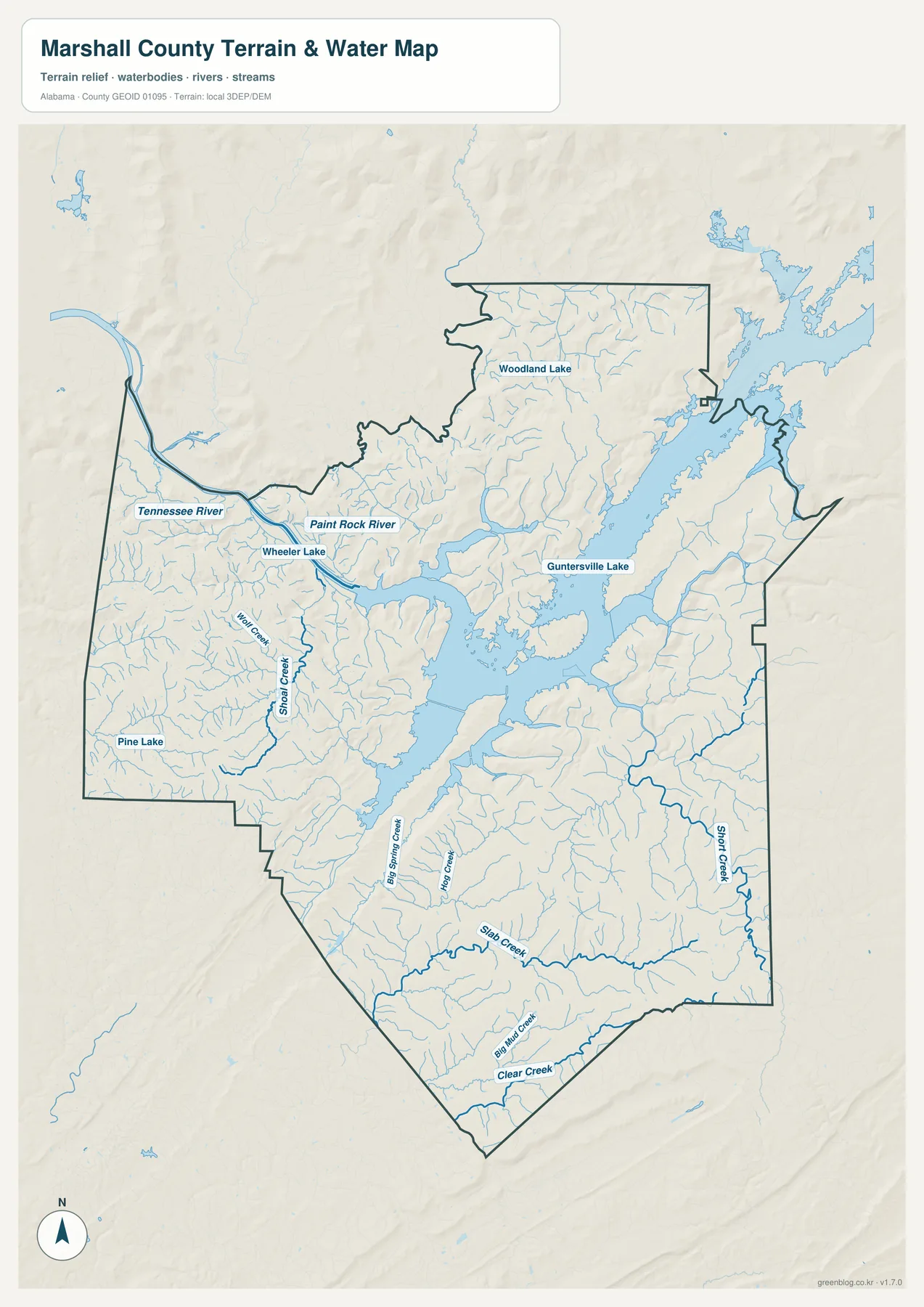
Smaller streams provide another layer of orientation. Shoal Creek is labeled on the western side, Big Spring Creek and Slab Creek appear in the south, and Short Creek runs along the eastern side. Clear Creek and other tributaries trace the lower valleys between ridges. These features make the local relief easier to recognize because stream lines tend to follow the lower ground.
For a classroom or planning overview, a useful sequence is to locate the reservoir first, then identify which city lies on which side of the water, and only then follow the smaller streams. That keeps the map readable and avoids treating every creek label as equally important.
Elevation from the reservoir lowlands to surrounding ridges
The elevation map reports an actual range of about 155 to 421 meters, with a mean of about 270 meters. The lowest greens follow Lake Guntersville and connected valleys. Higher browns and tans appear across northern and northeastern ridges, on parts of the western uplands, and through higher ground south and southeast of the reservoir. The shaded relief makes these changes visible even before reading the legend.
That relief helps explain the different settings of the main cities. Guntersville is closely associated with the lower reservoir corridor. Albertville and Boaz occupy the Sand Mountain highland, while Arab is on the Brindlee Mountain side to the west. Roads between these areas must cross slopes or follow valleys, so a short distance on the page can involve a noticeably different driving environment.
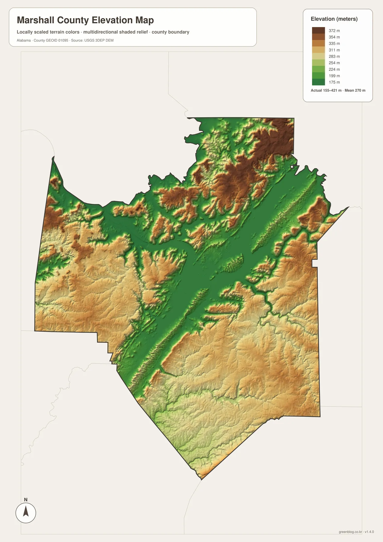
The elevation layer is generalized for county-scale viewing. It is useful for comparing broad high and low areas, but it is not a survey surface and should not be used for engineering design, building-site elevation, drainage approval, or slope-safety decisions. Those tasks require more detailed elevation data and site-specific measurements.
How roads, water, and relief change local travel
Marshall County is a good example of why a boundary map alone can be misleading. Lake Guntersville occupies enough space to funnel traffic toward bridges and causeways, while the uplands force many smaller roads to follow ridges and valleys. U.S. 431 is particularly important because it ties Guntersville to Albertville and Boaz across this terrain transition.
The western side works differently. U.S. 231 gives Arab a north-south connection that is more direct toward the Huntsville and Cullman sides than toward some communities east of the reservoir. Alabama 69 provides an important link back toward Guntersville. In the southeast, Albertville and Boaz share a road network that is more closely associated with U.S. 431 and Alabama 75.
For map reading, start with the general county sheet to establish cities and highways. Move to the city map if relative settlement size is the main question, to the water map if the reservoir and stream network matter, and to the elevation map if you need the broad shape of ridges and lowlands. Using all four in sequence gives a clearer picture without forcing every type of information onto one crowded page.
Frequently Asked Questions
Why are both Guntersville and Albertville important on a Marshall County map?
Guntersville is the county seat and the principal lakefront government center. The supplied county history also describes a courthouse in Albertville that was established to improve access for residents on the Sand Mountain side. Because the two cities serve different parts of the county and occupy very different terrain, both remain useful reference points.
Does Lake Guntersville affect driving routes inside the county?
Yes. The reservoir interrupts a simple road grid, so traffic is concentrated at bridges, causeways, and the major highways that connect the lake lowlands with surrounding uplands. Two points that look close on a county outline may require a longer route if they are on different sides of the water.
What is included in the downloadable ZIP?
The archive includes four A3 JPG files: the general county and road map, the six-city distribution map, the terrain-and-water map, and the elevation map. The page images are previews; the JPG files in the ZIP are the larger versions intended for downloading and printing.
Map File Information
Download four Marshall County A3 map files
- Included Files: 4 high-resolution A3 JPG map files shown in this article
- File Type: JPG files in a ZIP archive
- Intended Use: Printing, education, presentations, and map-based projects
Related Maps
- Abbeville, Headland, and Lake Eufaula on the Henry County Alabama Map
- Athens to Wheeler Reservoir on the Limestone County Alabama Map
- Autauga County Map
Sources and reference material
The article is based on the supplied Marshall County maps and county package. The following links are included for readers who want to check administrative information, population statistics, reservoir details, highway context, elevation data, or county history.
- Marshall County official government information – county administration
- U.S. Census Bureau QuickFacts – population and land-area statistics
- TVA Guntersville Reservoir information – reservoir size and management
- ALDOT Highway Functional Classification Maps – road-network reference
- USGS 3D Elevation Program – elevation-data background
- Encyclopedia of Alabama: Marshall County – county history and regional context
Green Map creates custom-edited map images using open geographic data sources such as geoBoundaries, Natural Earth, OpenStreetMap, and government open data. These maps are edited visual materials, not raw data files, and are provided for education, documents, presentations, and graphic reference.