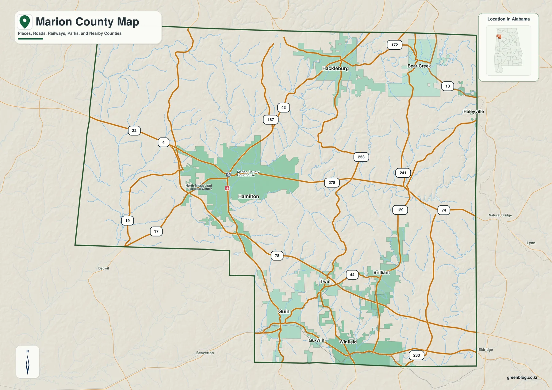
Download the Marion County Alabama Map on this page as a ZIP containing four high-resolution A3 JPG files, or use the on-page county, city, water, and elevation previews for quick reference. Hamilton is the best place to begin: it is the county seat, the largest city, and the junction of U.S. 43 and U.S. 278. From there, the map opens north toward Hackleburg, south toward Guin and Winfield, and east toward Bear Creek and Brilliant.
Marion County occupies the northwestern corner of Alabama along the Mississippi state line. Franklin County lies to the north, Winston and Walker counties are on the east, and Fayette and Lamar counties frame much of the south and southwest. The county does not have one continuous urban strip. Instead, several small towns are separated by wooded ridges, creek valleys, and long stretches of rural road, so a useful map needs more than a boundary and a single place label.
The four views emphasize different parts of that landscape. The county map combines roads, communities, streams, and the county line. The city view narrows the picture to six major population centers. The water map follows the Buttahatchee River, Bear Creek, and smaller tributaries, while the elevation map shows how lower valleys sit between higher ridges. Together they provide a practical orientation set rather than a parcel, flood, navigation, or engineering product.
Table of Contents
Start at Hamilton and work outward
| State | Alabama |
|---|---|
| County seat | Hamilton |
| Largest city | Hamilton |
| July 1, 2025 population estimate | 29,097 |
| 2020 census population | 29,341 |
| 2020 land area | 742.34 sq mi |
| Main routes | U.S. 43, U.S. 278, I-22/U.S. 78, AL 13, AL 129 |
| Major waters | Buttahatchee River, Bear Creek, Lake Buttahatchee |
Hamilton appears slightly west of the county’s center, but it functions as the clearest geographic anchor. The courthouse is marked in town, U.S. 43 runs north-south, and U.S. 278 crosses east-west. That combination makes Hamilton more useful for orientation than simply starting at the county boundary. Once it is located, Hackleburg is easy to place to the north, while Twin, Guin, Gu-Win, and Winfield line up farther south.
Brilliant is in the southeastern part of the county, and Bear Creek is well to the northeast. Haleyville is shown near the eastern side because most of the city is in Winston County but part of it extends into Marion County, and it remains a practical service and road reference for eastern communities. The general map also labels smaller nearby roads and streams, making it useful when a town name alone is not enough to understand how one part of the county connects to another.
The U.S. Census Bureau estimated 29,097 residents on July 1, 2025, compared with 29,341 counted in the 2020 census. Marion County has 742.34 square miles of land, so the population is spread over a large area rather than concentrated in a single metro-style center. The wide gaps between places on the map are therefore part of the county’s real geography, not just unused space in the design.
Six towns reveal three different parts of the county
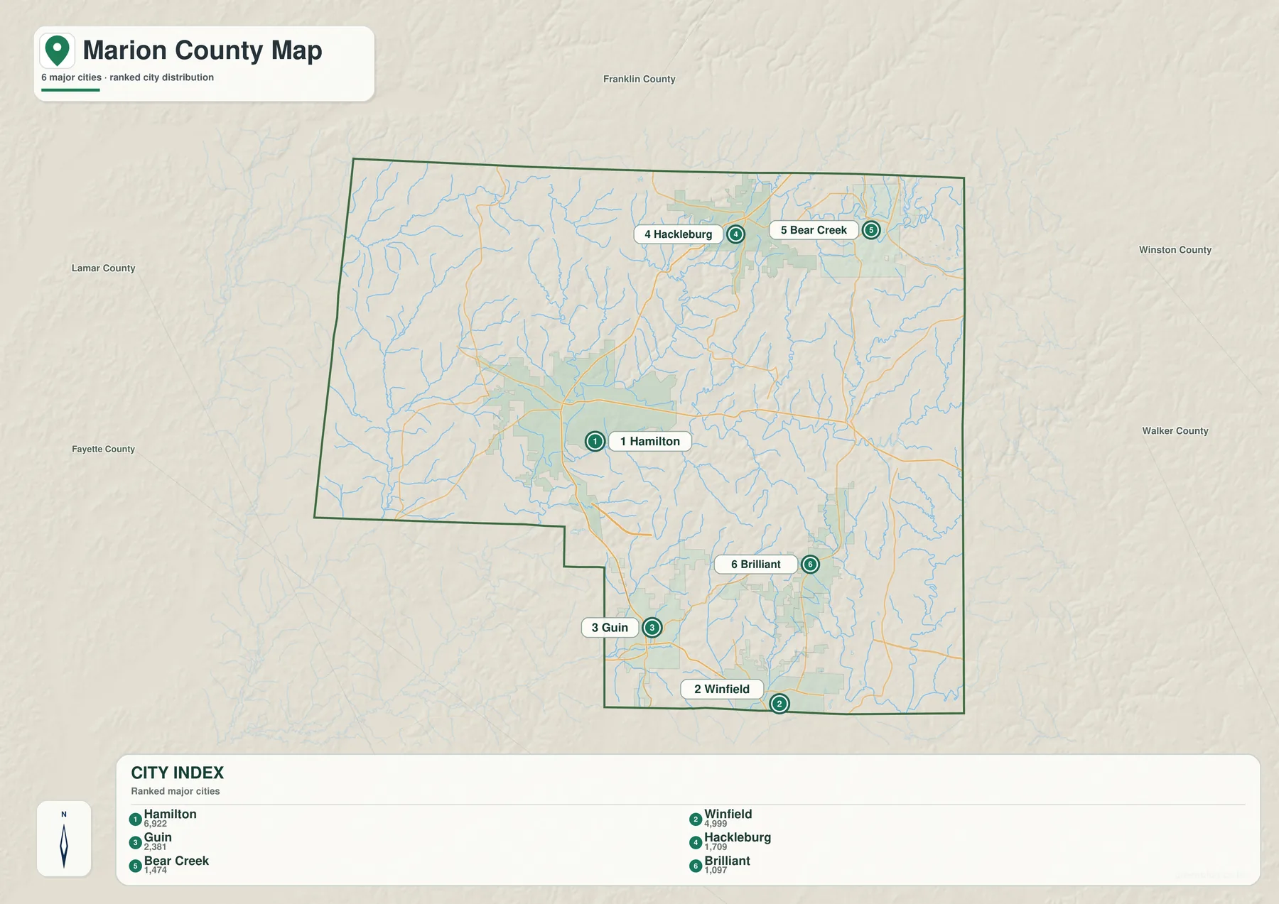
The supplied city index ranks Hamilton first at 6,922 residents, followed by Winfield at 4,999, Guin at 2,381, Hackleburg at 1,709, Bear Creek at 1,474, and Brilliant at 1,097. The ranking gives a quick sense of relative size, but location is the more useful feature. These communities are not packed together. They occupy distinct parts of the county and connect to different highways, neighboring counties, and local service areas.
Hamilton is the government and service center. Guin and Winfield form a stronger southern pair, with Gu-Win between them and I-22/U.S. 78 nearby. Winfield is close to the Fayette County line, while Guin sits on U.S. 278 and remains directly connected to Hamilton. The southern towns therefore have two orientations at once: toward the county seat for local administration and toward the interstate corridor for longer trips.
Hackleburg and Bear Creek define the northern half in a different way. Hackleburg sits on the U.S. 43 corridor and connects with Alabama 172, while Bear Creek lies farther east near Alabama 13 and the reservoir country. Brilliant gives the southeastern corner its own reference point. Its position near I-22 and the Winston County side makes it particularly helpful when a route crosses the county rather than ending in Hamilton.
The Buttahatchee River links the center to a dense creek network
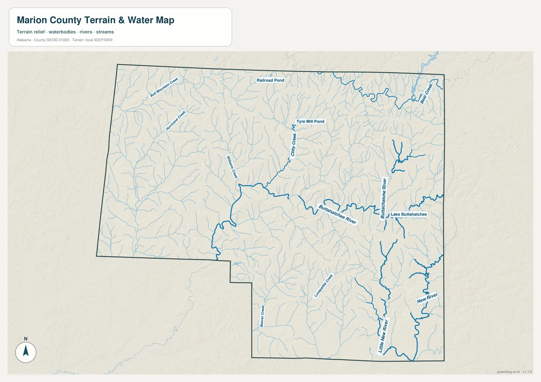
The Buttahatchee River is the most prominent named river in the central part of the water map. A USGS monitoring location near Hamilton lists a drainage area of 306 square miles, illustrating how much of the surrounding landscape feeds this system. The river and its tributaries are useful geographic guides because they cut across areas where town labels are sparse. They also explain why low valleys and road crossings matter even when no major community is nearby.
Bear Creek stands out in the northeast. The map also labels Railroad Pond and Tyre Mill Pond, while Williams Creek, Hurricane Creek, and Bull Mountain Creek appear farther west and north. Lake Buttahatchee is marked on the eastern side. In the southern portion, Little New River and New River are joined by smaller channels such as Luxapallila Creek and Beaver Creek. The result is a county divided into many small drainage valleys rather than one broad plain.
Upper Bear Creek Reservoir is another important reference for the northeastern area. Outdoor Alabama states that the reservoir was impounded in 1978 primarily for flood control and covers about 1,850 acres at full pool. It reaches the Marion, Franklin, and Winston county border area, which helps explain why Bear Creek has a stronger water-and-recreation identity than Hamilton or the southern interstate towns.
This view should be used for county-scale orientation only. It does not identify legal access, flood zones, current water levels, navigable channels, or parcel boundaries. Those questions require current agency information. Here, the benefit is seeing named rivers, creeks, and ponds in the same frame as the county boundary.
Rolling ridges rise above the lower stream valleys
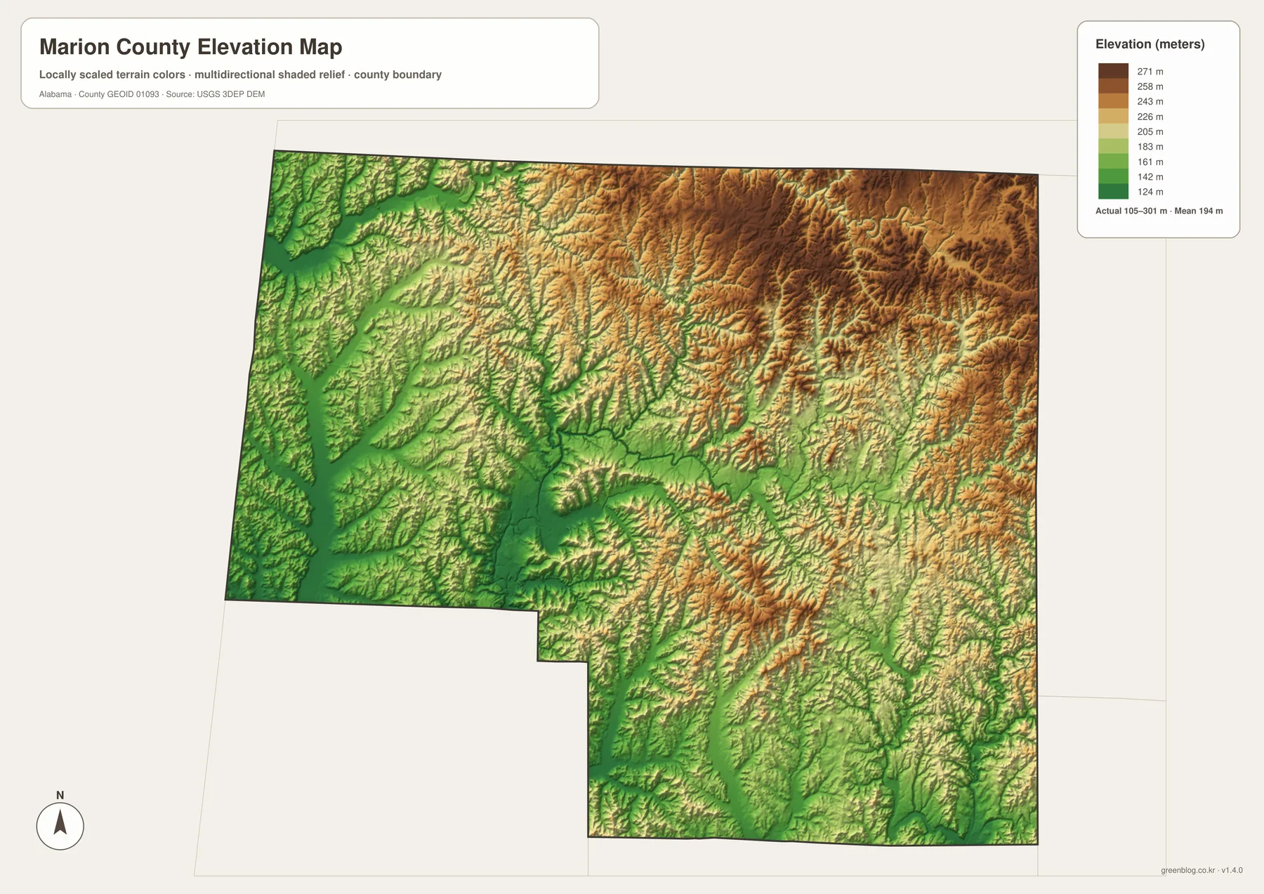
The elevation map reports an actual range of about 105 to 301 meters and a mean near 194 meters. Lower ground appears in green, especially along the western side and in stream valleys. Tan and brown ridges become more common toward the north and east. Marion County is not a mountain county, but the shaded relief makes its rolling uplands much more obvious than a road map does.
Comparing the elevation and water maps is especially useful. The Buttahatchee River and smaller creeks occupy lower corridors between ridges, while higher terrain separates one drainage valley from the next. The southern portion shows the same relationship around the Little New River and New River system. This repeated ridge-and-valley pattern helps explain why rural roads bend and why nearby communities may not be connected by a direct straight route.
The colors are intended for relative county-wide comparison. They should not be used as exact site elevations for construction, surveying, flood certification, or engineering. For those needs, the USGS 3D Elevation Program and appropriate field measurements provide the necessary source data.
U.S. 43 and U.S. 278 meet at Hamilton, while I-22 changes the south
U.S. 43 is the simplest north-south route to follow. It passes through Hamilton and continues toward the Guin–Winfield area in the south, while its northern direction reaches Hackleburg and Franklin County. U.S. 278 supplies the main east-west connection through Hamilton and Guin, linking the Mississippi side of the county with Winston County and the broader north Alabama road network.
I-22/U.S. 78 plays a different role. It crosses the southern county near Brilliant, Gu-Win, and Winfield, giving those communities a direct long-distance route toward Birmingham and Mississippi. That means southern Marion County can face outward toward the interstate corridor even while Hamilton remains the county-government center. Alabama 13 is important around Bear Creek and Haleyville, and Alabama 129 provides another southeastern connection through Brilliant.
For general trip planning, it is usually easiest to identify U.S. 43 and U.S. 278 first, then add I-22 for the southern corridor and the state routes for the eastern and northeastern towns. The county map is designed to establish that big picture. Detailed county roads, current construction, and turn-by-turn navigation should be checked with ALDOT and current navigation sources before travel.
Older travel routes still influence today’s town pattern
Marion County was created by the Alabama Territorial Legislature on February 13, 1818, before Alabama became a state. It was named for Revolutionary War general Francis Marion. The first permanent county seat was Pikeville, which is now abandoned, and county government later moved to Hamilton in the 1880s. Hamilton’s earlier name, Toll Gate, referred to a toll-collection point on Jackson’s Military Road, so its central transportation role has deep roots.
Railroads were just as important to several southern towns. Guin grew from a stop on the Birmingham–Memphis line in the 1880s, and Winfield expanded after rail service arrived in 1887. Brilliant developed around coal mining and rail shipment. I-22 and U.S. 78 now provide the dominant long-distance corridor across the south, but the spacing of towns on the modern map still reflects that older rail geography.
Hackleburg also carries a more recent history. The community suffered catastrophic damage during the April 27, 2011 tornado outbreak, including destruction of major public facilities, and rebuilding reshaped the town afterward. That history does not change its location on the map, but it adds context to why Hackleburg remains an important northern reference point despite its small population.
Choose the map by the question you need to answer
Use the county map when you need roads, boundaries, streams, and several named communities in one view. Switch to the city map when the relationship among Hamilton, Winfield, Guin, Hackleburg, Bear Creek, and Brilliant is the main question. The water map is better for the Buttahatchee River and the creek network, while the elevation map separates lower valleys from the higher ridges around them.
- County-wide orientation: roads, boundary, places, and nearby county context
- Town comparison: six ranked communities distributed across central, southern, and northern Marion County
- Water reference: Buttahatchee River, Bear Creek, Lake Buttahatchee, and smaller streams
- Terrain reference: roughly 105–301 meters of elevation and the contrast between valleys and ridges
Frequently Asked Questions
Why is Hamilton the best starting point on a Marion County map?
Hamilton is the county seat, the largest city, and the junction of U.S. 43 and U.S. 278. From that central reference, Hackleburg is to the north, Guin and Winfield are to the south, and Bear Creek and Brilliant are easier to place toward the east.
What files are included in the downloadable ZIP?
The archive contains four high-resolution A3 JPG maps: a county reference map, a six-city map, a water map, and an elevation map. The four files cover different questions without requiring separate downloads.
Can the water and elevation maps be used for flood or engineering decisions?
No. They are county-scale reference maps. Flood risk, parcel boundaries, legal access, and exact site elevations require current official data and, when appropriate, professional surveying or engineering information.
Map File Information
Download the Marion County map files
- Included Files: 4 high-resolution A3 JPG map files shown in this article
- File Type: JPG files in a ZIP archive
- Intended Use: Printing, education, presentations, and map-based projects
Related Maps
- Abbeville, Headland, and Lake Eufaula on the Henry County Alabama Map
- Athens to Wheeler Reservoir on the Limestone County Alabama Map
- Autauga County Map
Sources and Reference Data
- U.S. Census Bureau QuickFacts – population and land-area reference
- Encyclopedia of Alabama: Marion County – county history and local context
- ALDOT Highway Functional Classification Maps – highway and road reference
- USGS Buttahatchee River near Hamilton – river and drainage reference
- Outdoor Alabama: Upper Bear Creek Reservoir – reservoir information
- USGS 3D Elevation Program – elevation source data
Green Map creates custom-edited map images using open geographic data sources such as geoBoundaries, Natural Earth, OpenStreetMap, and government open data. These maps are edited visual materials, not raw data files, and are provided for education, documents, presentations, and graphic reference.