Claiborne County sits in southwestern Mississippi, where a winding Mississippi River boundary meets a much hillier interior around Port Gibson. This page brings together roads, settlements, lakes, creeks, and elevation so the county can be understood from more than one map. The A3 high-resolution JPG files used for this set are also available as a ZIP download below. Looking at the maps side by side is especially useful here because the low river edge in the west and the dissected uplands in the east look very different even though they belong to the same county.
Table of Contents
Start with Port Gibson and follow the road network
Port Gibson is the clearest place to begin because it is the county seat and sits close to the center of the main road network. US 61 passes through the area and continues south, while other routes branch toward the northern and eastern parts of the county. Hermanville is labeled east of Port Gibson, Pattison appears farther southeast, and Alcorn State University provides a useful landmark in the southwest. The map makes it clear that settlement is spread across a large rural county rather than concentrated in one continuous urban area.
Several numbered routes help with orientation. Route 462 crosses the northern interior, MS 18 reaches the eastern side, and routes 547 and 548 serve the southeast. Route 552 is shown near Alcorn State University, while US 61 provides the most obvious north-south reference through Port Gibson. These lines are not a substitute for turn-by-turn navigation, but they are useful when a reader needs to see which communities share the same general travel direction and where a route meets the county boundary.

Why Port Gibson stands out on the city map
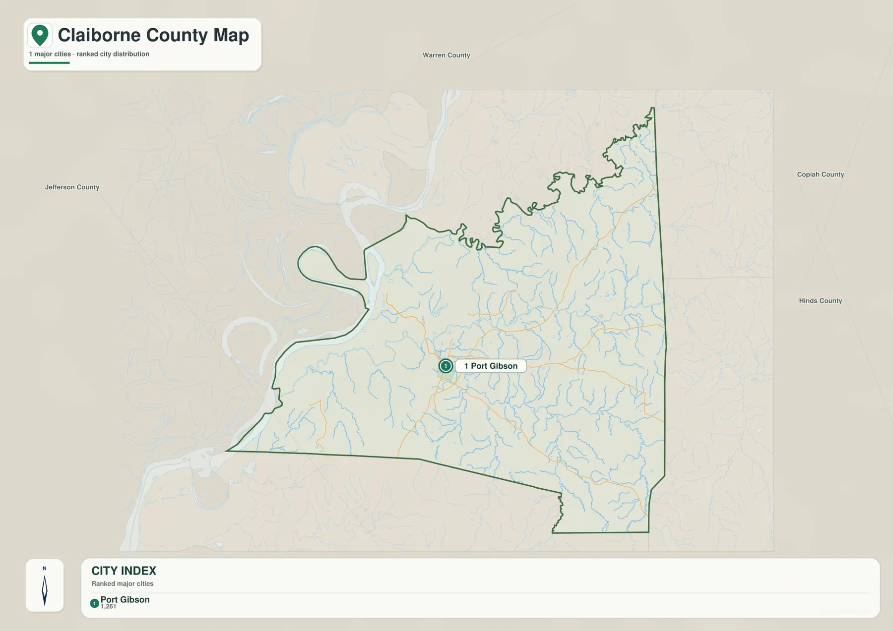
The city-focused map strips away much of the extra detail and makes Port Gibson the dominant settlement label. It is the only major city listed in the city index on this map. Around the county outline, labels for Warren, Copiah, Hinds, and Jefferson counties help place Claiborne County within southwestern Mississippi. That simpler view is useful when the main question is not about every road or stream, but about where the county seat lies and how the county is positioned relative to its neighbors.
The simplified city view should be read together with the general county map. Port Gibson is the administrative center, but Hermanville, Pattison, Alcorn State University, and other local references show that the county extends well beyond the seat. This distinction matters for school projects, local history, and regional presentations because a single town marker cannot represent the full shape or geography of Claiborne County.
A winding river edge, oxbow lakes, and a dense creek network
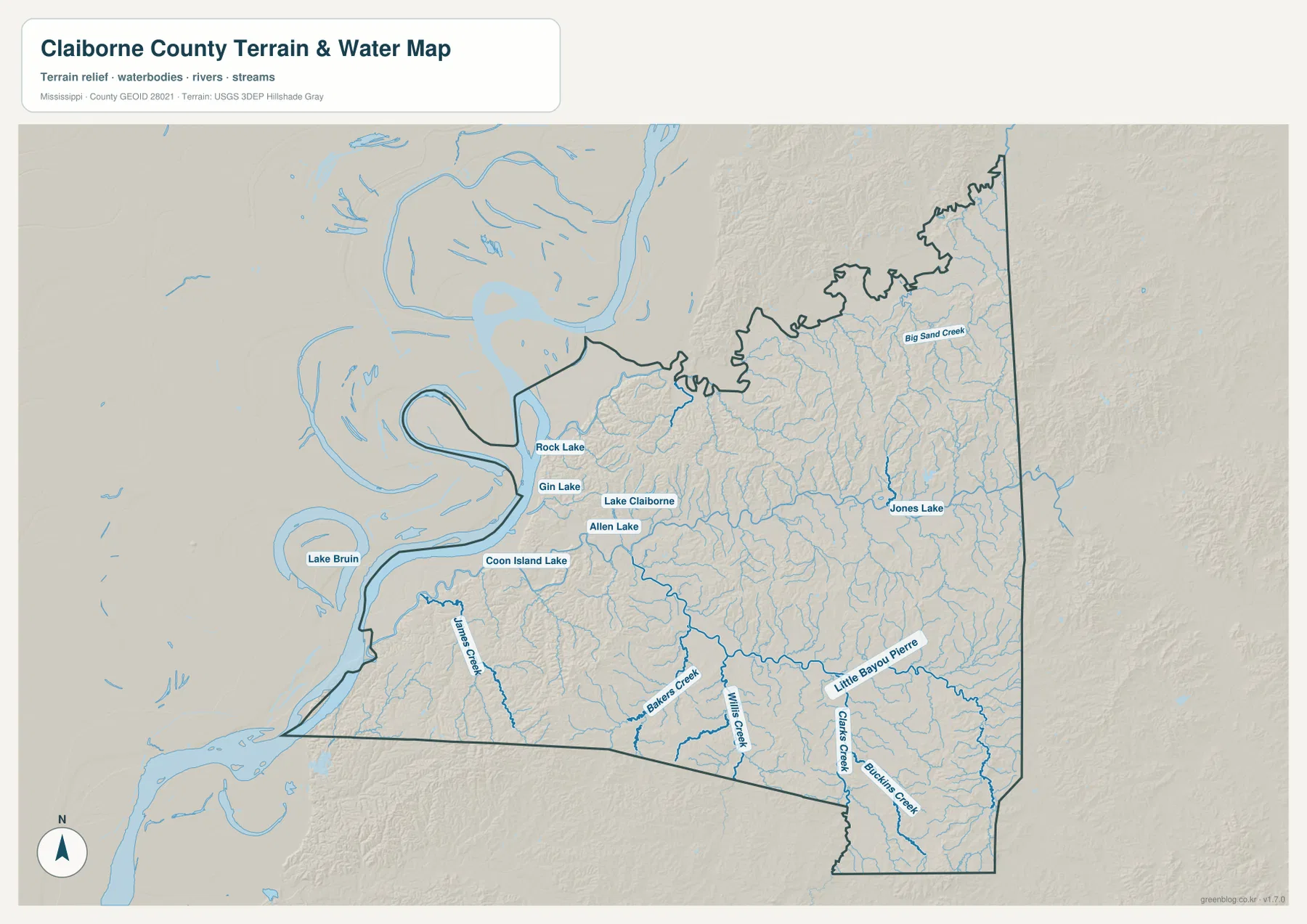
The western edge of Claiborne County is one of its most distinctive map features. Instead of following a straight survey line, the boundary bends with the Mississippi River and includes several pronounced curves. The terrain-and-water map adds much more detail to that river setting. Rock Lake, Gin Lake, Lake Claiborne, Allen Lake, and Coon Island Lake are labeled in the western and west-central part of the county, while Jones Lake appears farther east. Lake Bruin is visible beyond the county on the Louisiana side, providing additional context for the broad lowland beside the Mississippi River.
Water continues far into the interior through smaller streams. Big Sand Creek is labeled in the northeast, and James Creek, Bakers Creek, Hills Creek, Little Bayou Pierre, and Clarks Creek appear across the central and southern parts of the county. Their branching lines occupy narrow valleys between higher ridges. This is why the water map can look surprisingly intricate even away from the Mississippi River itself: many small channels drain the broken upland surface before joining larger streams.
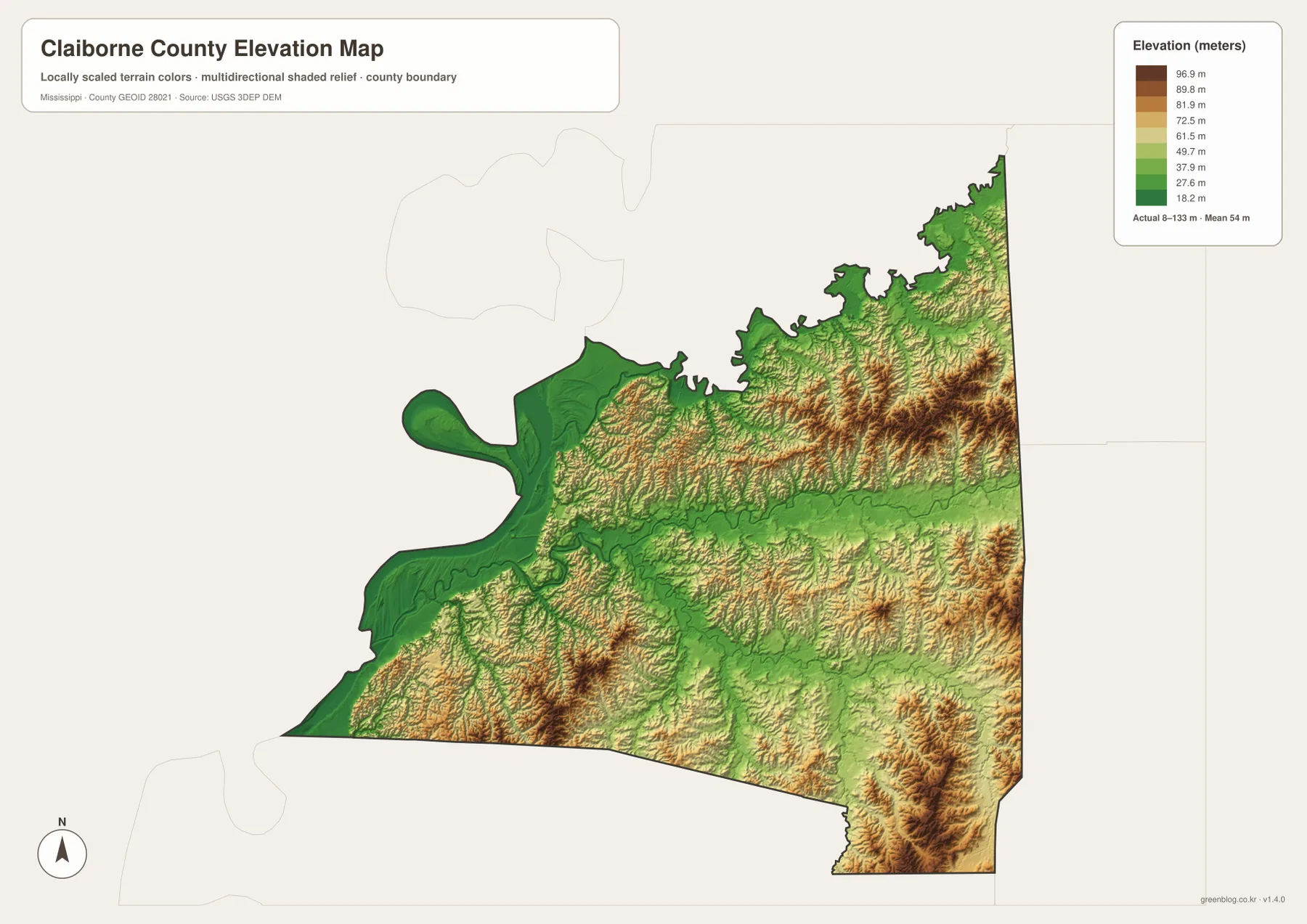
The elevation map explains the sharp west-to-east contrast
Elevation is the key to understanding why western Claiborne County looks so different from the eastern half. The map reports an actual elevation range of about 8 to 133 meters, with a mean near 54 meters. Dark green covers much of the Mississippi River side, indicating broad low ground. East of that lowland, the surface becomes increasingly ridged, and yellow to brown tones mark higher ground separated by many narrow valleys.
The northeast contains some of the clearest ridge-and-valley texture, and another group of higher hills is visible in the southeast. The river side, by comparison, has fewer abrupt changes in elevation. Port Gibson lies inland from the main Mississippi River channel, near the transition between the lower western country and the more broken uplands. That setting becomes much easier to understand after comparing the road map with the elevation map rather than relying on the county outline alone.
County facts to keep beside the maps
- County seat: Port Gibson
- FIPS code: 28021
- 2020 census population: 9,135
- July 2025 population estimate: 8,058
- 2025 Gazetteer area: 487.415 square miles of land and 13.788 square miles of water
- Elevation shown on this map: about 8–133 m, mean about 54 m
The 2020 census count and the July 2025 estimate refer to different dates, so they should not be treated as two measurements from the same year. The Gazetteer also separates land from water rather than combining them into a single number. Keeping those distinctions in view avoids turning basic reference figures into claims they were not designed to make. The maps are most useful when those numbers are paired with the visible distribution of roads, water, settlements, and terrain.
Choose the map that matches the question
For a quick look at Port Gibson, county boundaries, and numbered roads, the general county map is the best starting point. The city map is cleaner when the goal is to show Port Gibson as the primary settlement and place Claiborne County among surrounding counties. The water map is better for readers studying the Mississippi River edge, lakes, creeks, and Little Bayou Pierre. The elevation map is the strongest choice for explaining why the river side is low while the eastern half is cut by higher ridges and narrow valleys.
These differences also matter when the map will be printed. A classroom handout may need the road and place labels, while a geography lesson may benefit more from the water or elevation view. The page previews are WebP images for efficient browsing, but the download package contains the matching high-resolution A3 JPG files for printing, editing, or reuse in a presentation.
Frequently Asked Questions
Is Port Gibson directly on the Mississippi River?
No. Port Gibson is inland from the main Mississippi River channel. The maps show lower river-side ground to the west and a transition into higher, more broken terrain toward Port Gibson and the eastern interior.
Which lakes and creeks are labeled on the Claiborne County water map?
The map labels Rock Lake, Gin Lake, Lake Claiborne, Allen Lake, Coon Island Lake, and Jones Lake. Named streams include Big Sand Creek, James Creek, Bakers Creek, Hills Creek, Little Bayou Pierre, and Clarks Creek, among others.
How much does elevation vary across Claiborne County?
The elevation map reports an actual range of roughly 8 to 133 meters and a mean near 54 meters. The lowest broad areas are along the Mississippi River side, while higher ridges are much more common in the eastern and northeastern parts of the county.
Map File Information
The ZIP contains high-resolution A3 JPG maps for Claiborne County boundaries and roads, Port Gibson, water features, and elevation.
- Included Files: county map, city map, water map, elevation map
- File Type: JPG
Related Maps
Sources and References
- U.S. Census Bureau QuickFacts – Claiborne County
- U.S. Census Bureau Gazetteer Files
- USGS National Hydrography
- USGS 3D Elevation Program
- Mississippi Department of Transportation Official Highway Map
- Mississippi Encyclopedia – Claiborne County
Green Map creates custom-edited map images using open geographic data sources such as geoBoundaries, Natural Earth, OpenStreetMap, and government open data. These maps are edited visual materials, not raw data files, and are provided for education, documents, presentations, and graphic reference.