Clarke County sits in eastern Mississippi, with Quitman serving as the county seat and a useful reference point for roads that spread toward Enterprise, Stonewall, Pachuta, and Shubuta. The maps on this page are designed to show more than the county outline. They separate settlement and road information from waterways and elevation, so a reader can see why the western I-59 and US 11 side feels different from the US 45 corridor around Quitman and from the river valleys farther south. High-resolution A3 JPG versions of the supplied maps are also available in the ZIP download box near the end of the article.
The strongest geographic feature is not a single highway or town. Clarke County is crossed by several road systems while the Chunky River and Chickasawhay River occupy lower corridors between rolling uplands. The elevation map adds another layer by showing an actual range of about 49 to 181 meters, with a mean near 96 meters. When the road, water, and elevation views are compared, the county becomes easier to understand as a long area of separated towns, branching streams, and narrow ridges rather than as a simple rectangle on a state map.
Table of Contents
Quitman and the split between US 45 and the western interstate side
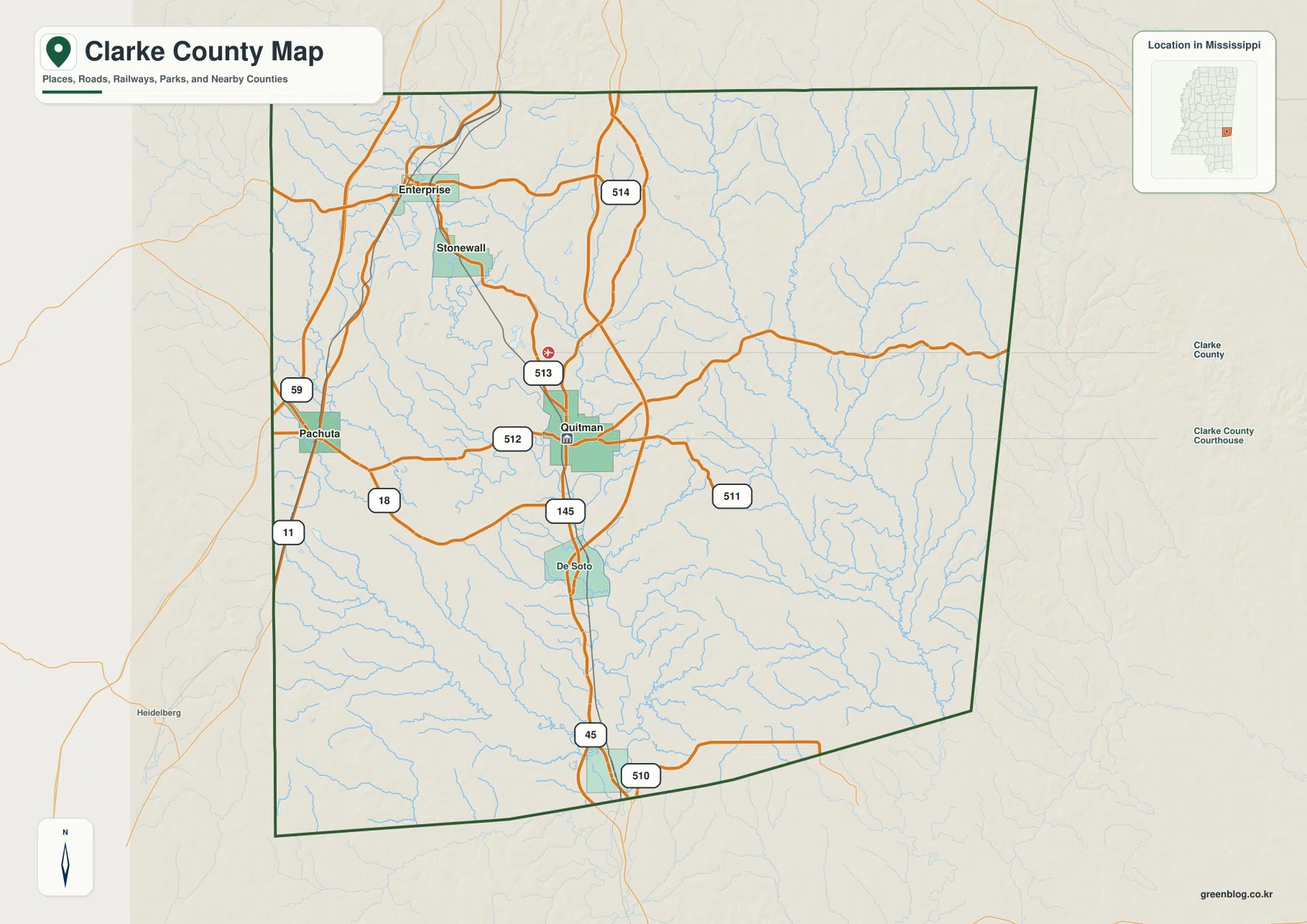
The general county map places Quitman slightly east of the county’s center. US 45 runs through the Quitman area and continues south, while several numbered state routes branch away from it. Route 513 approaches from the north, Route 512 comes in from the west, and Route 511 extends toward the east. South of Quitman, De Soto appears along the same broad north-south side of the county, and Route 145 continues through that area. Route 510 is labeled near the southern boundary, adding another reference point for the lower end of the US 45 corridor.
The western side follows a different pattern. I-59 and US 11 are closest to Pachuta and the Enterprise side rather than to Quitman itself. MS 18 crosses the western part of the county and helps tie that side back toward the interior. Enterprise is in the northwest, Stonewall lies southeast of Enterprise, and Pachuta is farther west. Looking at those places together makes an important point: the county’s main road references do not form one continuous line through every town. The interstate and US 11 corridor belongs to the west, while Quitman is more directly associated with US 45.
Smaller route labels fill in the interior connections. Routes 514, 513, 512, 511, 145, and 510 are all visible on the supplied map. They are useful for orientation because they show how local travel fans away from Quitman and links back toward the western side. This map is not a substitute for turn-by-turn navigation or current road-condition information, but it clearly establishes which towns and corridors occupy the same part of Clarke County and which require movement across the county.
Five mapped places spread from Enterprise to Shubuta
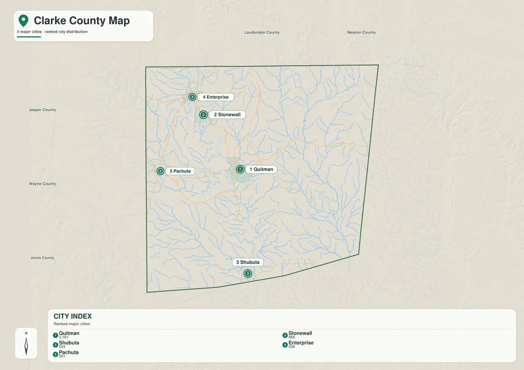
The city map strips away much of the road detail and emphasizes five labeled places: Quitman, Stonewall, Shubuta, Enterprise, and Pachuta. Quitman sits in the east-central part of the county. Stonewall and Enterprise are both north and west of Quitman, with Enterprise farther toward the northwestern corner. Pachuta is placed on the western side, while Shubuta is close to the southern boundary. The separation is useful because it shows that the county’s recognizable towns are distributed across a large north-south and east-west area rather than clustered around a single urban center.
Quitman and Stonewall may appear relatively close on a statewide map, but the county view makes their distinct positions clearer. Enterprise is farther northwest, close to the road corridor associated with I-59 and US 11. Pachuta provides another western reference, and Shubuta anchors the southern portion of the county near the Chickasawhay River system. Around the outside of the county, the map labels Lauderdale County, Newton County, Jasper County, Wayne County, and Jones County, which helps place Clarke County within eastern Mississippi without adding unrelated statewide detail.
The numbered city index should be read as a simple way to locate the major places shown on this map. It does not describe commuting patterns, municipal influence, or a single shared urban area. Used beside the general road map, however, it becomes very helpful: the city map clarifies where the places sit, while the road map explains the different routes that connect or separate them.
The Chunky and Chickasawhay rivers organize the water map
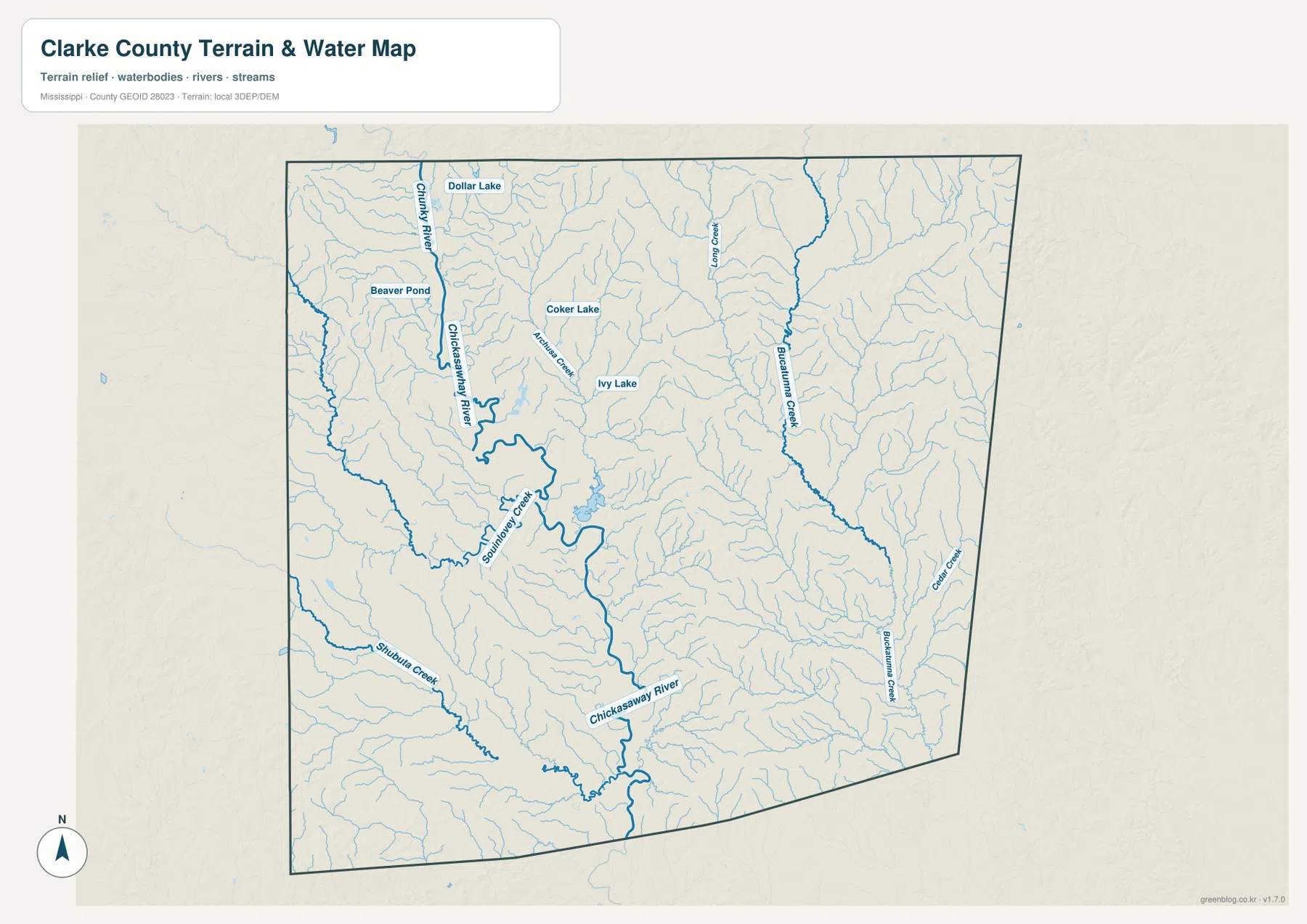
The terrain-and-water map gives the county a much more intricate appearance. The Chunky River enters from the northwestern side and runs southward, while the Chickasawhay River becomes the dominant named channel through the west-central and southern interior. Numerous smaller tributaries feed those larger rivers. Because many of the small streams branch repeatedly, the map shows that much of Clarke County is divided by narrow drainage valleys even where the general road map appears relatively open.
Several named creeks help identify different parts of the county. Souinlovey Creek and Shubuta Creek are labeled west and southwest of the central Chickasawhay channel. Archusa Creek and Long Creek appear farther north, while Buckatunna Creek and Cedar Creek are visible on the eastern side. These names are useful for orientation because they show that the water network extends across the county rather than being confined to the Chickasawhay River alone. In the southern area near Shubuta, multiple tributaries approach larger channels, making the water pattern especially dense.
The same map also labels smaller water bodies. Dollar Lake and Beaver Pond appear in the northwest, while Coker Lake and Ivy Lake are farther toward the northern interior. They are not portrayed as huge reservoirs, but their labels add local detail that a river-only map would miss. The map should be used as a reference for the location of rivers, creeks, lakes, and general terrain. It is not a flood-risk map, a navigation chart, or a source of parcel-level water boundaries.
A 49–181 meter relief range of narrow ridges and low river corridors
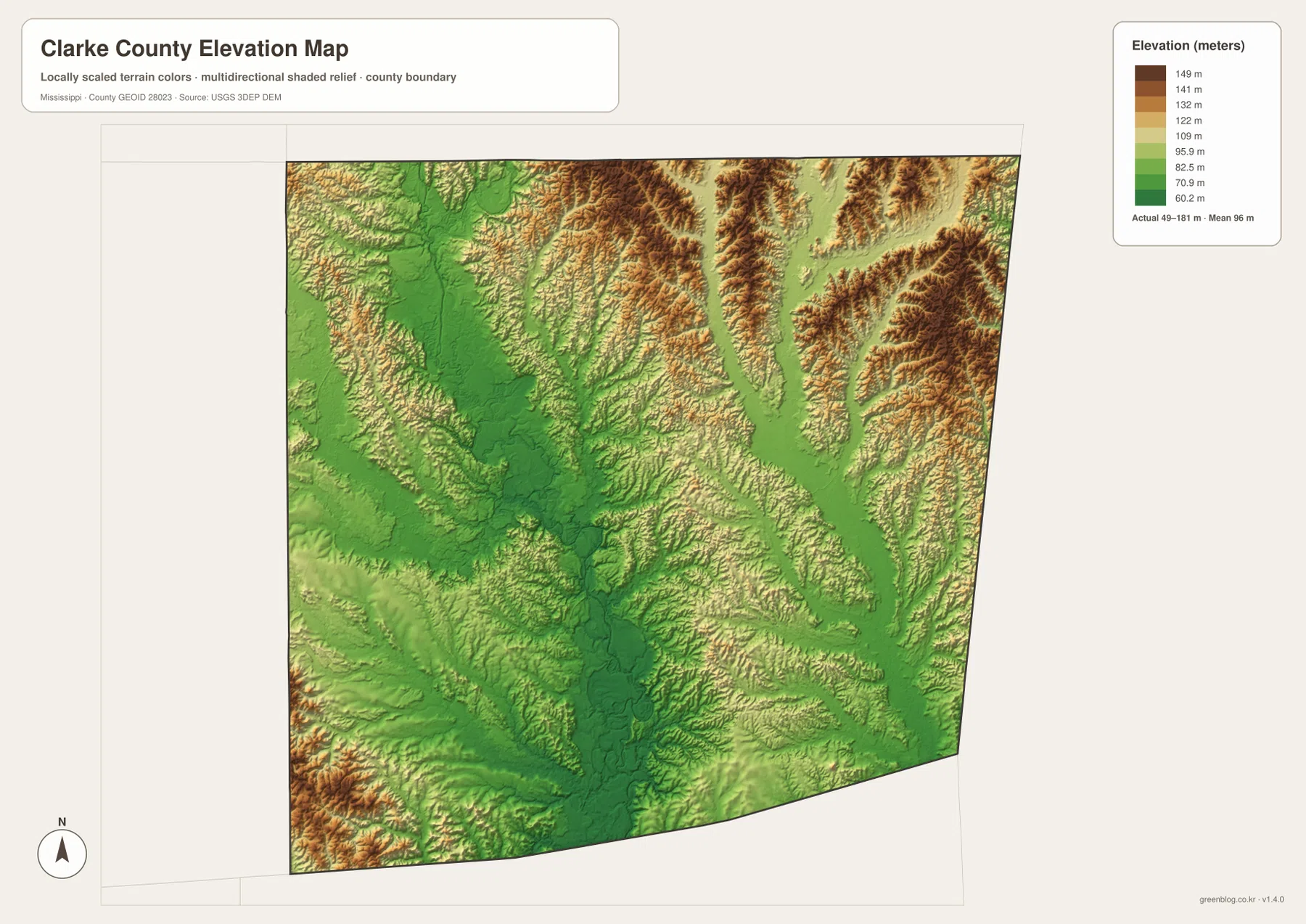
The elevation map reports an actual range from about 49 to 181 meters and a mean elevation near 96 meters. Its strongest brown and tan colors appear on many ridges in the northeast and along portions of the eastern side. A few higher areas also occur near the southwestern edge. In contrast, broad green corridors run through the lower central and western interior and continue toward the south. Comparing those green areas with the water map shows that many follow the same general country occupied by the Chunky and Chickasawhay river valleys.
Clarke County does not have one isolated high peak dominating the map. Instead, the higher ground is broken into many narrow ridges separated by branching valleys. The northeastern quarter shows especially tight ridge-and-valley texture, while the eastern side contains repeated strips of higher terrain. Those ridges explain why streams are so numerous: water descends through the lower gaps between uplands and gathers into larger channels. The result is a landscape that changes elevation frequently over short distances even though the county is not mountainous.
This elevation layer is intended for broad geographic comparison. It can help explain why the river corridors appear low and why the eastern and northeastern parts look more dissected, but it is not survey-grade elevation for construction, engineering, or property decisions. For a classroom map or regional overview, its greatest value is that it turns the branching creek network into something visually understandable by showing the ridges on both sides of the valleys.
Reference facts to keep beside the maps
- County seat: Quitman
- FIPS code: 28023
- 2020 census population: 15,615
- July 2025 population estimate: 15,102
- 2025 Gazetteer area: 691.576 square miles of land and 1.959 square miles of water
- Elevation shown on this map: about 49–181 m, mean about 96 m
The 2020 census count and the July 2025 estimate refer to different dates, so they should not be treated as two observations from the same year. The Gazetteer likewise separates land area from water area. These figures are best used as basic county references rather than as substitutes for what the maps show. They provide scale, while the maps show where the principal towns, roads, streams, and high and low terrain are located.
The supplied source material also gives a countywide 2020 land-area density of about 22.6 residents per square mile. That figure is a countywide calculation, not the density of Quitman, Stonewall, Shubuta, or any other individual place. The city map itself shows why that distinction matters: the major settlements are widely separated, and large areas between them are occupied by streams, valleys, and uplands rather than one continuous built-up zone.
Why the separated towns matter in Clarke County’s local history
The county background material included with this package notes that rail connections and timber processing influenced the growth of communities such as Enterprise, Stonewall, and Shubuta. The present maps do not attempt to reconstruct old industrial sites or historic rail alignments, but the distribution of towns still provides useful context. Enterprise and Stonewall occupy the northern half, Quitman serves as the county seat farther east and south, and Shubuta lies much farther down the Chickasawhay side of the county.
That history is most useful when kept tied to features that are actually shown. The city map locates the communities, the road map shows current route relationships, and the water map explains the river setting around places such as Shubuta. There is no need to infer an unshown mill, rail spur, or industrial district. The visible geography already demonstrates that Clarke County developed around several separated places rather than one large urban core.
Match the map to the question you need to answer
Use the general county map when the main question is where Quitman, Enterprise, Stonewall, Pachuta, and Shubuta sit relative to I-59, US 11, US 45, and the numbered state routes. The city map is better when road detail would be distracting and the goal is simply to compare the five labeled places. For rivers and tributaries, the terrain-and-water map provides much more information than the road map. For a lesson about ridges, valleys, or why streams follow certain low areas, the elevation map is the strongest companion.
The WebP images on the page are optimized for browsing. If you need a larger image for printing, a presentation, or closer inspection, use the ZIP below. It contains the matching high-resolution A3 JPG files for the county map, city map, water map, and elevation map. Keeping the files separate makes it possible to use only the view that fits the task, or to place several views side by side when explaining how roads, waterways, and relief relate to one another.
Frequently Asked Questions
Does I-59 pass directly through Quitman?
No. On the supplied county map, I-59 is on the western side near the Pachuta and Enterprise approaches. Quitman lies farther east and is more directly associated with US 45 and several numbered state routes. This is why the interstate side and the Quitman side are clearer when treated as separate road corridors.
How do the Chunky and Chickasawhay rivers appear on the water map?
The Chunky River enters from the northwestern part of the county and trends southward, while the Chickasawhay River is the major named channel through the west-central and southern interior. Souinlovey Creek, Shubuta Creek, Archusa Creek, and many smaller tributaries join the broader network, producing a dense pattern of valleys around the larger rivers.
Where does the elevation map show the highest terrain?
Higher ridges are most prominent in the northeastern and eastern parts of the county, with additional higher ground near the southwestern edge. The map reports an overall range of about 49 to 181 meters and a mean near 96 meters. Lower green corridors are more common through the central-western and southern river valleys.
Map File Information
The ZIP provides high-resolution A3 JPG maps of Clarke County roads and places, city distribution, waterways, and elevation.
- Included Files: county map, city map, water map, elevation map
- File Type: JPG
Related Maps
Sources and References
- U.S. Census Bureau QuickFacts – Clarke County
- U.S. Census Bureau Gazetteer Files
- USGS National Hydrography
- USGS 3D Elevation Program
- Mississippi Department of Transportation Official Highway Map
- Mississippi Encyclopedia – Clarke County
Green Map creates custom-edited map images using open geographic data sources such as geoBoundaries, Natural Earth, OpenStreetMap, and government open data. These maps are edited visual materials, not raw data files, and are provided for education, documents, presentations, and graphic reference.