Cheyenne County occupies the far northwestern corner of Kansas, and the supplied maps make St. Francis and Bird City the easiest places to use as anchors. St. Francis sits west of center, Bird City lies farther east, and U.S. 36 connects the two across the middle of the county. This page combines a general county map with separate city, water-and-terrain, and elevation views. High-resolution JPG originals corresponding to the web maps are available together in the download box below.
The county may look like a broad, open High Plains landscape at first glance, but the drainage and elevation maps show considerable relief. South Fork Republican River crosses the southwestern part of the county, while Hackberry Creek, Cherry Creek, Big Timber Creek, Little Beaver Creek, and many shorter tributaries cut a network of valleys through the uplands. The elevation map reports an actual range of about 916 to 1163 meters, with a mean near 1055 meters, so the difference between western high ground and lower stream corridors is substantial.
A practical way to read the county is to begin with St. Francis, Bird City, and U.S. 36, then trace the major waterways and compare the same areas on the elevation layer. The Kansas Historical Society places Cheyenne County in the state’s Northwest and High Plains regions and identifies St. Francis as the county seat. That regional setting matches what is visible in the supplied maps: broad uplands broken by deeply incised drainage lines rather than a uniformly flat surface.
Table of Contents
Finding Cheyenne County through St. Francis, Bird City, and U.S. 36
St. Francis is the most obvious place name on the general county map. U.S. 36 passes through town and continues east toward Bird City, giving the county a clear central reference line. Routes 27 and 217 appear near St. Francis, while route 161 is prominent around Bird City. The southern half contains a much denser pattern of numbered local routes, whereas the northern half is visually dominated by branching stream lines. That contrast makes the central highway corridor especially useful for orientation.
The county boundary should be read together with nearby labels. Sherman County lies to the west, while the map points toward Rawlins County and Thomas County on the eastern side. McDonald appears just outside the county to the east, providing another useful external reference. These surrounding names help prevent a common map-reading mistake: treating every visible town or road label as if it were inside Cheyenne County itself.
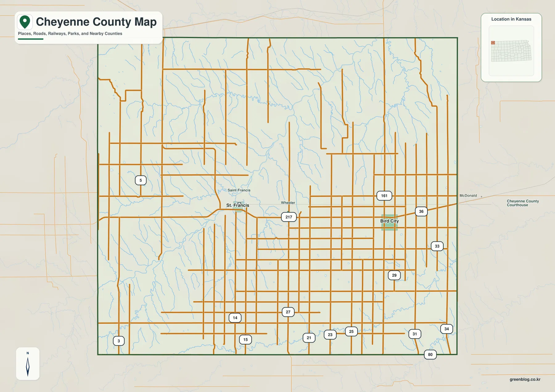
The general map works best as an overall reference because roads, place names, county lines, and smaller waterways remain visible in one view. Its density can also make some natural features harder to follow. Around St. Francis, for example, a regular road grid overlays a complicated drainage pattern. Moving to the water map reveals how many short tributaries cross the same area, while the elevation layer explains why those channels form distinct valleys across what otherwise looks like open country.
A Two-Center Settlement Pattern across a Large Rural County
The ranked city map emphasizes two major places: St. Francis and Bird City. St. Francis is shown as the larger center, with Bird City ranked second. Rather than forming one continuous urban area, the two communities are separated by a broad stretch of rural land along the U.S. 36 corridor. This spacing is important when reading the rest of the maps because named streams and terrain features often cover much larger areas than the compact city symbols suggest.
St. Francis is close to the South Fork Republican River drainage and a dense web of local roads. Bird City sits farther east where the road network remains regular but the surrounding drainage pattern changes. The city map intentionally reduces background detail, making the separation between the two communities easy to see. The general map can then be used to restore the smaller road labels and nearby waterways when more context is needed.
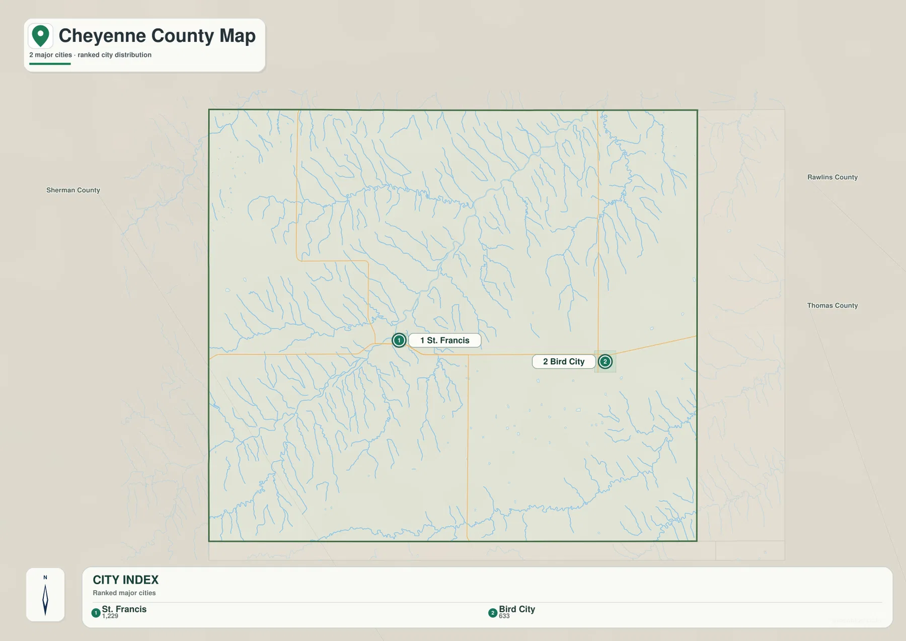
The ranked values on this map should be treated as part of the supplied cartographic product rather than a substitute for current population estimates. If a project requires the latest demographic figures, a current official statistical source should be checked separately. For this page, the important point is geographic: St. Francis and Bird City provide two strong anchors for matching roads, drainage basins, and elevation patterns across a sparsely settled county.
South Fork Republican River and a Network of High Plains Creeks
The strongest named water feature on the terrain-and-water map is South Fork Republican River. It crosses the southwestern part of Cheyenne County and gathers several tributaries that descend from surrounding uplands. Cherry Creek joins the same broad drainage area, and numerous unnamed branches cut into the slopes north and south of the river. These channels explain why the western part of the elevation map contains so many narrow green valleys between higher orange and brown ridges.
Hackberry Creek stretches across the northwestern and north-central part of the county. Farther east, Big Timber Creek becomes a major labeled feature, accompanied by Jones Canyon Creek near the northeastern edge. Bull Creek, Plum Creek, Spring Creek, and West Fork Sand Creek appear closer to the center, while Little Beaver Creek forms a pronounced drainage line across the southeastern section. The result is not one simple river corridor but several drainage systems spread across the county.
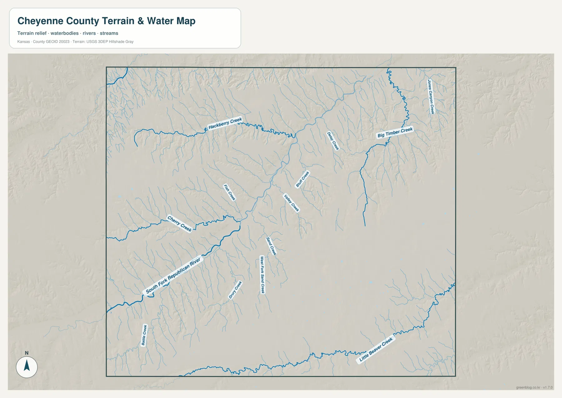
The water layer is useful for geographic context, but it is not a live hydrologic or flood map. A mapped creek line does not indicate current flow, depth, access, or flood conditions. Seasonal and storm-driven changes can be significant on High Plains streams. For travel, emergency planning, or water management, current official observations are more appropriate. Here, the map is best used to understand where valleys occur and how smaller channels connect to larger drainage corridors.
The high-resolution version is particularly helpful for short tributaries that are difficult to see in the reduced page image. Enlarging the St. Francis area shows how the South Fork Republican system divides the nearby uplands. In the north, Hackberry Creek can be followed across a long distance, while the eastern file makes Big Timber Creek and Little Beaver Creek easier to separate from their smaller branches. Printing the water map by itself also removes much of the visual competition from road labels.
Elevation from 916 to 1163 Meters across the Western High Ground
The supplied elevation map gives an actual county range of roughly 916 to 1163 meters, with an average near 1055 meters. The highest colors are concentrated in the west and southwest, where broad brown and orange areas dominate. Lower greens become more common toward the northeast and along major drainage corridors. A total spread of about 247 meters is enough to produce a much more varied landscape than a simple description of “flat plains” would suggest.
Small streams carve deeply into the western uplands, creating narrow valleys that stand out clearly in the shaded relief. A broad low corridor associated with the South Fork Republican drainage crosses the county, while the northeast contains many branching depressions linked to smaller creeks. The eastern side around Bird City is generally lower than the western high ground, but it is not featureless. Ridges and tributary valleys continue across the landscape at a finer scale.
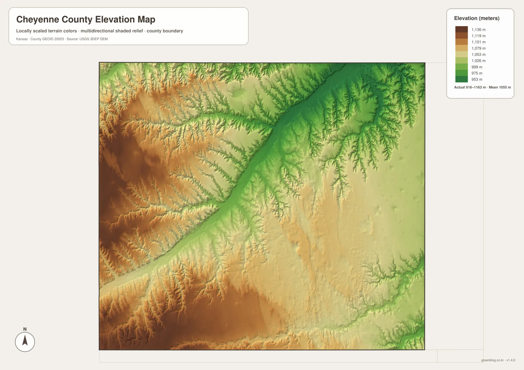
This elevation layer is intended for broad geographic comparison rather than parcel-level measurement. Color classes and shaded relief make ridges and valleys easier to recognize, but they do not replace a survey or engineering-grade elevation model for construction, drainage design, or property work. For those purposes, the underlying USGS data or professional survey information should be used. On this page, the map is most useful for seeing the county-wide transition from higher western terrain toward lower eastern and stream-cut areas.
Using the Road Grid without Losing the Terrain
U.S. 36 is the simplest route for connecting the two principal mapped communities. Around St. Francis, routes 27 and 217 provide additional local references; around Bird City, route 161 helps identify the eastern side. South of the main corridor, routes 14, 15, 21, 23, 25, 29, 31, 34, and 80 appear among a dense grid of local roads. On the general map this pattern looks highly regular, but the stream and elevation layers show that the roads cross many small valleys and changes in relief.
That difference is useful when planning a classroom exercise or preparing a printed regional reference. A straight road symbol is easy to follow, while the natural landscape beneath it may be much more complex. Comparing a road segment near St. Francis with the same location on the water map reveals nearby tributaries; doing the same around Bird City shows a different drainage pattern and generally lower elevation. The maps complement one another without requiring every feature to be displayed at once.
For real travel, the maps should not be treated as live navigation. Road construction, closures, surface conditions, and weather can change after the map was produced. Their strength is geographic orientation: locating St. Francis and Bird City, understanding which numbered routes provide the main references, and seeing how those roads relate to the county boundary and the surrounding High Plains terrain.
What the High-Resolution JPG Downloads Add
The web previews are convenient for seeing the overall pattern, but the original JPG files preserve much more detail. Each original is 3638 by 2572 pixels, which makes small route numbers, short stream names, and shaded relief easier to inspect. The archive includes the general county map, ranked city map, water-and-terrain map, and elevation map shown on this page, so the same location can be compared without relying on the reduced web images.
For a place-based comparison, begin with St. Francis and Bird City on the general map, then use the water layer to follow South Fork Republican River, Hackberry Creek, or Big Timber Creek. The elevation file adds another dimension by showing how those drainage lines fit into higher and lower ground. Three different map views of the same area often make the relationship among settlements, waterways, and relief clearer than a single crowded map.
The files are suitable for general geographic reference, personal study, classroom materials, presentation slides, and ordinary printing. They are not legal boundary records, parcel maps, flood determinations, live road-condition products, or professional surveys. When a task requires those kinds of authoritative details, the source agencies linked below should be consulted directly.
Frequently Asked Questions
Which map is best for locating St. Francis and Bird City?
Start with the general county map because both communities are labeled along U.S. 36 and the surrounding numbered routes remain visible. The ranked city map then simplifies the same relationship and emphasizes St. Francis and Bird City as the two principal mapped centers. Once their positions are familiar, it is easier to match them with nearby drainage and elevation patterns.
Where is South Fork Republican River on the map?
South Fork Republican River is the most prominent labeled waterway in the southwestern portion of the water-and-terrain map. Cherry Creek and many smaller tributaries connect with the same broad drainage area. On the elevation map, the associated valley appears lower than much of the surrounding western upland. The maps provide geographic context only and should not be used as live flood or stream-condition information.
What is included in the Cheyenne County download ZIP?
The archive contains four high-resolution JPG originals matching the maps on this page: the general county map, ranked city map, water-and-terrain map, and elevation map. Each image is 3638 by 2572 pixels. They are useful for zooming, ordinary printing, classroom work, and geographic reference, but they do not replace legal, engineering, emergency, or survey products.
Map File Information
Download the high-resolution JPG originals corresponding to the Cheyenne County general map, city map, water-and-terrain map, and elevation map shown on this page.
- File Type: ZIP containing 4 JPG files
Related Maps
Sources and References
Authoritative background sources include the U.S. Census Bureau TIGER/Line Shapefiles, USGS National Hydrography, and USGS 3D Elevation Program. County history, regional classification, and confirmation of St. Francis as the county seat are available from the Kansas Historical Society Cheyenne County, Kansas profile. Geographic descriptions on this page focus on features visible in the supplied maps.
Green Map creates custom-edited map images using open geographic data sources such as geoBoundaries, Natural Earth, OpenStreetMap, and government open data.
These maps are edited visual materials, not raw data files, and are provided for education, documents, presentations, and graphic reference.