Wilkes County in eastern Georgia is organized around Washington, where several major numbered roads converge before spreading toward smaller communities and the county boundary. Tignall sits to the north, while Rayle lies to the west. The supplied maps add a second layer of detail by showing Broad River and Little River drainage, a dense network of creeks, and rolling terrain that changes from higher interior ridges to lower stream valleys. Used together, the maps make it easier to understand why Washington stands out as the county’s main road and settlement hub.
You can download all four Wilkes County maps on this page as high-resolution A3 JPG files in one ZIP archive. The body of the article uses lighter WEBP previews for quick viewing, while the download contains the original county, city-connections, water-and-terrain, and elevation maps. That combination works well for classroom geography, local research, printed handouts, genealogy orientation, presentations, or any project that needs more than a single boundary map.
Table of Contents
Washington anchors a road network that reaches every side of the county
The general county map makes Washington the most obvious reference point. The city is slightly south of the county’s center and is surrounded by the densest cluster of roads and mapped development. Tignall appears well to the north, while Rayle is west of Washington. Adasburg is labeled farther east, and surrounding places such as Lexington, Lincolnton, and Woodville appear outside the county boundary, helping place Wilkes County within the broader part of eastern Georgia.
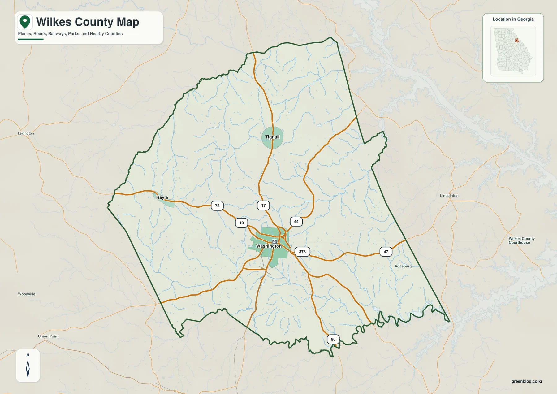
The road pattern explains why Washington is so useful as a starting point. Route 78 approaches from the west and reaches Washington, while 378 continues eastward from the city. Route 17 comes down from the Tignall area, 44 heads toward the northeast, and 80 runs toward the southern boundary. Route 47 is visible on the east side. The map is not meant to replace a turn-by-turn road map, but it clearly shows that Washington is where several county-scale travel directions meet.
This map is especially helpful when the question is broad: Where is the county seat? Which side of the county is Tignall on? How does Rayle relate to Washington? Where do the main roads cross the county line? It does not attempt to show every local street, driveway, parcel line, or unincorporated place. For a county overview, that simplification is useful because the main settlement and road relationships remain easy to see.
Tignall and Rayle sit in different directions from the Washington hub
The city-connections map strips away much of the road detail and concentrates on Washington, Tignall, and Rayle. Washington is marked as the hub. Tignall is about 9 miles north of it, while Rayle is about 10 miles to the west. Those figures are straight-line distances printed on the supplied city map, not driving distances. A road trip between the places can be longer because actual routes follow the road network rather than a direct line.
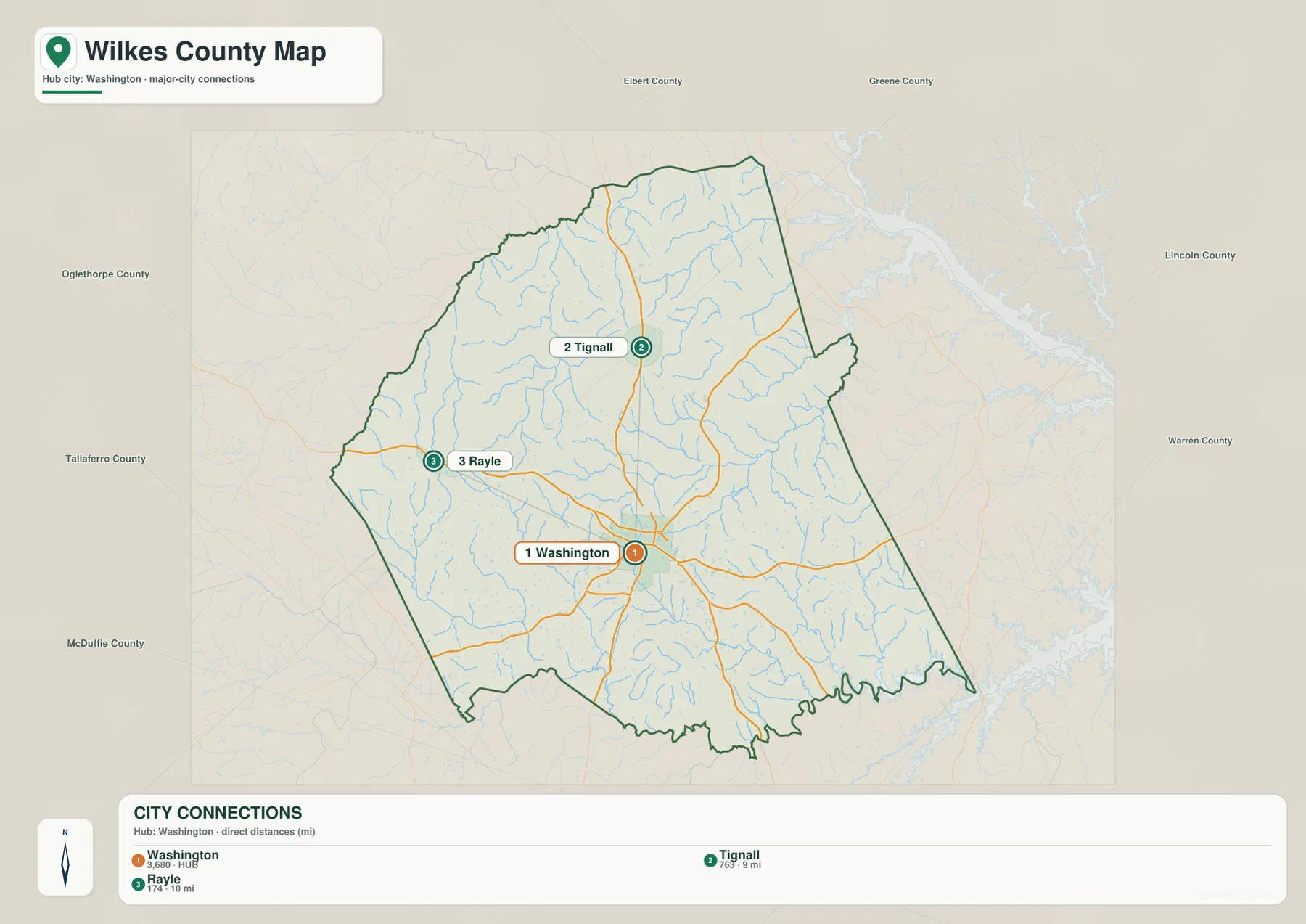
The map also prints reference values of 3,680 for Washington, 763 for Tignall, and 174 for Rayle. Because those numbers are part of the supplied graphic, they are best treated as map reference values rather than a substitute for current population statistics. Anyone who needs a current population estimate, demographic change, or official census count should consult a current Census Bureau source. For visual comparison, however, the numbers reinforce the much larger role of Washington relative to the other two labeled towns.
There is a practical reason to keep this simplified city map separate from the general county map. A presentation about settlement spacing or county-seat relationships is easier to follow when only three places are emphasized. Once the reader needs the actual route between Washington and Tignall or the road approaching Rayle, the general map becomes the better reference. The two maps answer related questions without duplicating the same visual emphasis.
Broad River and Little River frame a dense network of creeks
The water-and-terrain map changes the focus from roads to drainage and landform. Broad River is labeled along the northern side of the county, while Little River appears in the southwest. Between them, numerous named creeks cut through the rolling terrain. Clark Creek is prominent on the western side, and Chickasaw Creek and Pistol Creek appear farther north. Anderson Mill Creek crosses the middle of the map, while Morris Creek and Fishing Creek are visible toward the east.
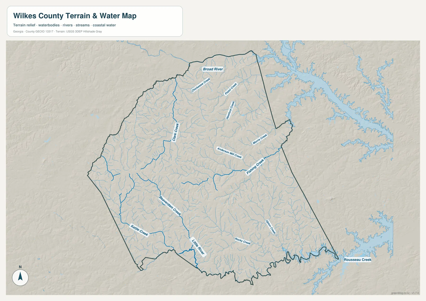
Kettle Creek is labeled in the southwest, with Beaver Dam Creek nearby. The existing Wilkes County article also connects the Kettle Creek name with the county’s Revolutionary War history, giving the waterway added local context beyond its physical location. The map itself is not a historic-site map, so it should not be used to locate a battlefield or specific historic property. Its value here is showing where the creek sits in relation to the county’s other drainage lines and rolling terrain.
Farther south and east, Rocky Creek and Boone Creek are visible, and Rousseau Creek is labeled just beyond the southeastern edge. The map shows why a simple statement such as “Wilkes County has rolling hills” is incomplete: the hills are repeatedly cut by narrow stream valleys. Those valleys help organize the drainage pattern from the interior toward larger rivers. This map is a county-scale water reference, not a flood-hazard, wetland-regulation, depth, navigation, or legal-boundary product.
Elevation ranges from about 99 to 217 meters across rolling ridge country
The elevation map reports an actual range of roughly 99 to 217 meters, with a mean near 153 meters. Wilkes County is not mountainous, but the shaded relief shows strong local variation. Higher brown and orange terrain is concentrated across parts of the west and interior, where branching ridges form a textured pattern. Lower green areas follow many stream valleys and are especially noticeable near the southern and southeastern boundary.
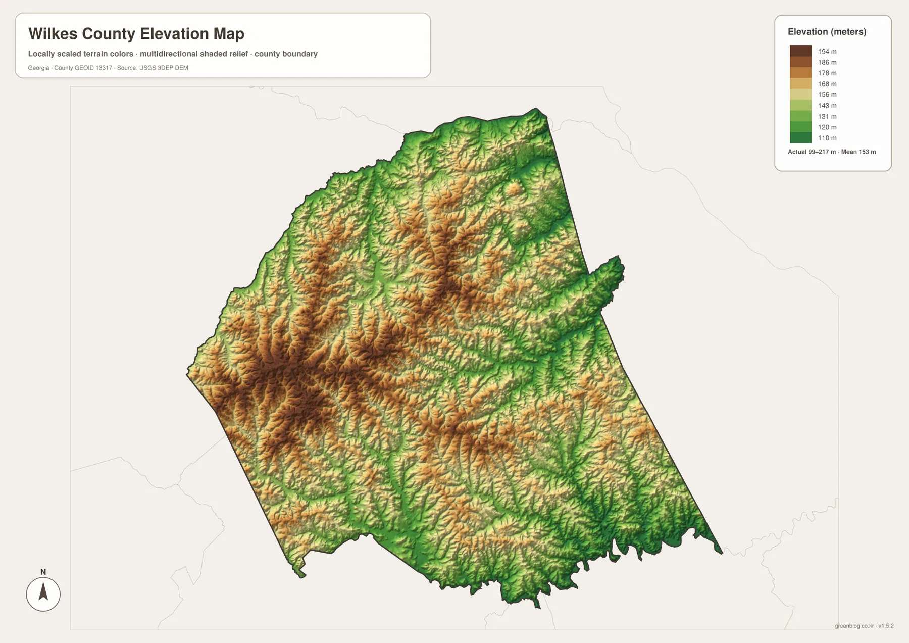
Comparing the elevation map with the water map makes the relationship between terrain and drainage much easier to recognize. Many blue stream lines occupy the green lower zones, while the higher ridges separate neighboring drainage paths. The Broad River corridor and the winding southern edge of the county are associated with lower terrain, while broad interior areas rise above those valleys. Washington appears in rolling country rather than on one of the county’s highest ridge crests.
This is a generalized county elevation reference. The color transitions are not survey contours, and the map is not intended to supply construction elevations, engineering grades, parcel-level slope measurements, or drainage design values. It is appropriate for comparing relative high and low areas, explaining how streams occupy valleys, or adding terrain context to a county geography lesson. Precision work should use current survey-grade or purpose-specific elevation data.
Reading roads, waterways, and relief together gives Washington more context
Washington dominates the general map because roads converge there, but the other maps show that the county around it is far from flat or empty. Numerous creeks cut across a rolling surface, and the elevation map shows ridges rising between those valleys. Roads crossing the county therefore connect communities through a landscape of repeated low rises and drainage corridors rather than across a featureless plain. Seeing those layers together gives a more realistic picture of the county than a boundary outline alone.
Tignall and Rayle provide two good examples. Tignall is north of Washington and sits closer to the higher northern interior, while Rayle is west of the county seat in an area crossed by several tributaries. The city map gives the direction and straight-line distance, the general map supplies the road connection, and the water and elevation maps add the surrounding physical setting. That sequence is useful when teaching students how different map types answer different parts of the same geographic question.
The Kettle Creek label can be used in a similar way for local-history orientation. A reader can first locate the creek on the water map, then consult a reliable historical source for the broader Revolutionary War story mentioned in the existing county material. This keeps the map page focused on geography while still providing a bridge to local history. The same approach works for Broad River, Little River, and other named creeks when a research project needs both location and background information.
Choose the map file that matches the question
For a county boundary, major-road overview, or quick Washington reference, start with the general map. Use the city-connections map when the main task is comparing Washington, Tignall, and Rayle without extra road detail. Choose the water map for Broad River, Little River, Kettle Creek, and tributary relationships, and use the elevation map when higher ridges and lower valleys are the main subject. The WEBP versions on the page are convenient for screen viewing, while the downloadable archive is better suited to saving, printing, and reusing the original map files.
- Boundary and roads: general county map centered on Washington and the major numbered routes
- Town spacing: city-connections map showing Tignall and Rayle relative to Washington with straight-line distances
- Rivers and creeks: water-and-terrain map for Broad River, Little River, Kettle Creek, and tributaries
- Terrain: elevation map for comparing the county’s roughly 99–217 meter range
Frequently Asked Questions
Are the Tignall and Rayle distances driving distances?
No. The city map labels Tignall at about 9 miles from Washington and Rayle at about 10 miles, and those figures are straight-line distances. Driving distances can be longer because actual roads follow the county’s road network and terrain.
How much elevation change does the Wilkes County map show?
The supplied elevation map shows an actual range of about 99 to 217 meters and a mean near 153 meters. That is enough to reveal higher interior ridges and lower stream valleys, even though the county is not a mountain region.
Can the water map be used for flood or property decisions?
No. It is a county-scale reference for the location of rivers and creeks such as Broad River, Little River, and Kettle Creek. Flood zones, wetland jurisdiction, water depth, parcel boundaries, and other legal or engineering decisions require current purpose-specific data.
Sources and Reference Data
County background and current statistical reference can be checked through U.S. Census Bureau QuickFacts and The New Georgia Encyclopedia’s Wilkes County article. For the type of water and elevation information represented by the supplied maps, see USGS National Hydrography and the USGS 3D Elevation Program.
Map File Information
The ZIP contains four original high-resolution A3 JPG maps for Wilkes County: county, city connections, water and terrain, and elevation.
- Included Files: County map, city map, water map, elevation map
- File Type: ZIP containing four JPG files
Related Maps
Green Map creates custom-edited map images using open geographic data sources such as geoBoundaries, Natural Earth, OpenStreetMap, and government open data. These maps are edited visual materials, not raw data files, and are provided for education, documents, presentations, and graphic reference.