Hamilton County sits in Central Texas where a compact network of towns and highways crosses a much more intricate landscape of creeks, river valleys, and higher ground. Hamilton occupies the central part of the county and works well as the first reference point, while Hico lies close to the northern edge. The maps on this page let you compare county boundaries, the two ranked cities, waterways, and elevation without treating those layers as separate topics. You can also download the original high-resolution JPG map files together in a ZIP from the map file box near the end of the article.
The county map shows U.S. 281 running through Hamilton toward Hico, with State Highway 22 and State Highway 36 branching eastward and U.S. 84 crossing the southern part of the county. The water map adds the Leon River, Cowhouse Creek, Lampasas River, and smaller tributaries, while the elevation map shows a clear contrast between higher terrain in the southwest and lower river valleys in the central and eastern parts of the county. Reading those features together gives a more useful picture of Hamilton County than a boundary outline alone.
Table of Contents
Hamilton and Hico anchor different parts of the county
The city distribution map highlights Hamilton and Hico as the two ranked major cities in the supplied dataset. Hamilton is near the middle of the county, slightly east of center, while Hico is positioned near the northern boundary. That spacing is useful because it divides the county into two easy reference areas: Hamilton for the central and southern road network, and Hico for the northern approach toward Erath and Bosque counties. The official Hamilton County website also identifies Hamilton as the county seat and names Hamilton and Hico as the county’s two largest towns.
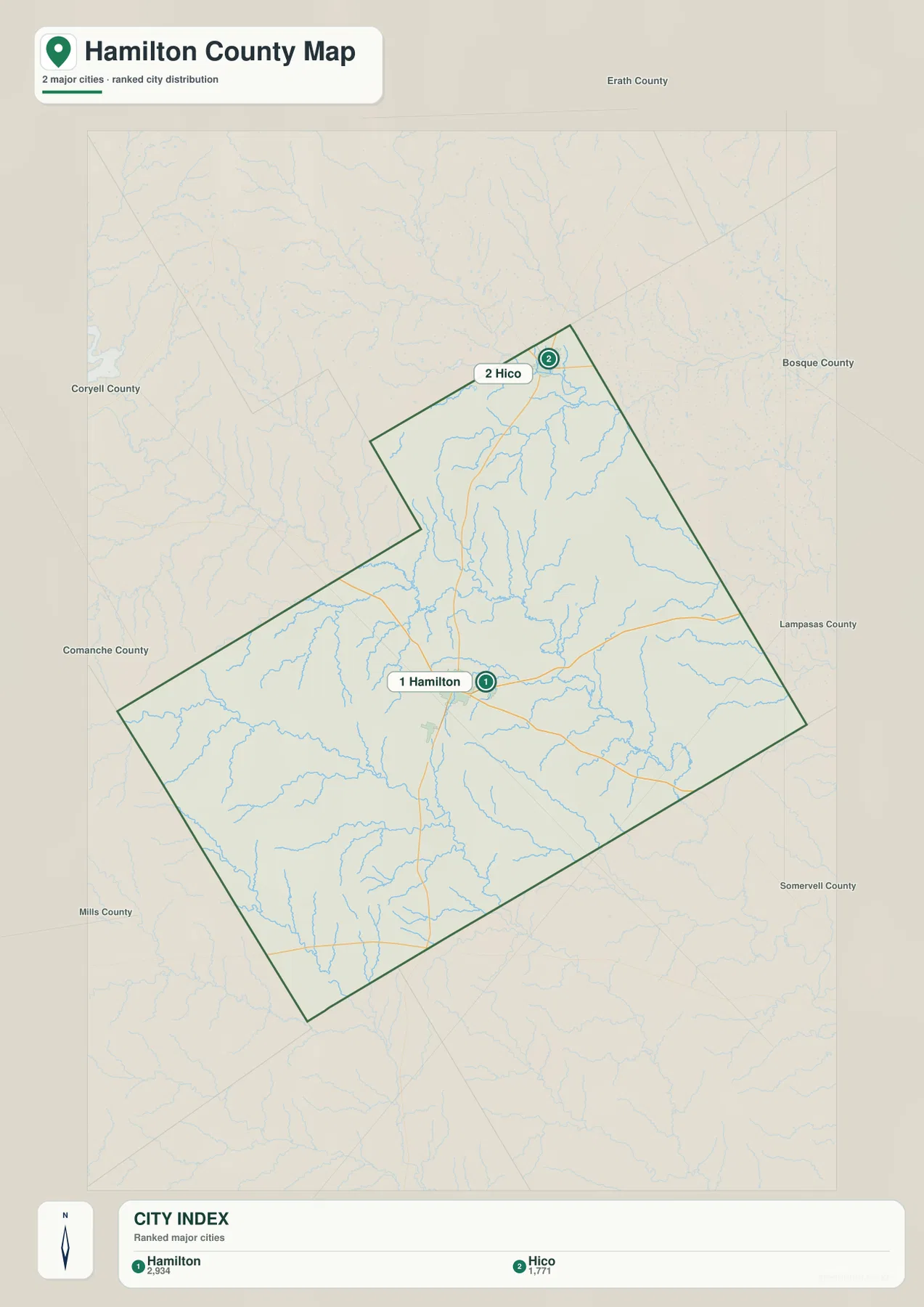
The map also labels neighboring counties around the boundary. Erath County appears to the north, Bosque County to the northeast and east, Coryell and Lampasas counties to the southeast and south, and Mills and Comanche counties to the west. These labels are helpful when you need to understand which direction a road is taking after it leaves the county. They also keep Hico from looking isolated: its northern location makes more sense when the nearby Erath and Bosque county lines are visible.
U.S. 281 provides the clearest north–south reference
U.S. 281 is the easiest road to use when orienting yourself on the general county map. It enters from the south, passes directly through Hamilton, and continues north to Hico. Around Hamilton, State Highway 22 runs east and State Highway 36 heads toward the southeast. U.S. 84 crosses the lower part of the county near the southern boundary, and roads 6 and 220 are shown near Hico. Rather than reading each road as an isolated line, it is more helpful to use Hamilton as the central junction and then follow each route toward the county edge.
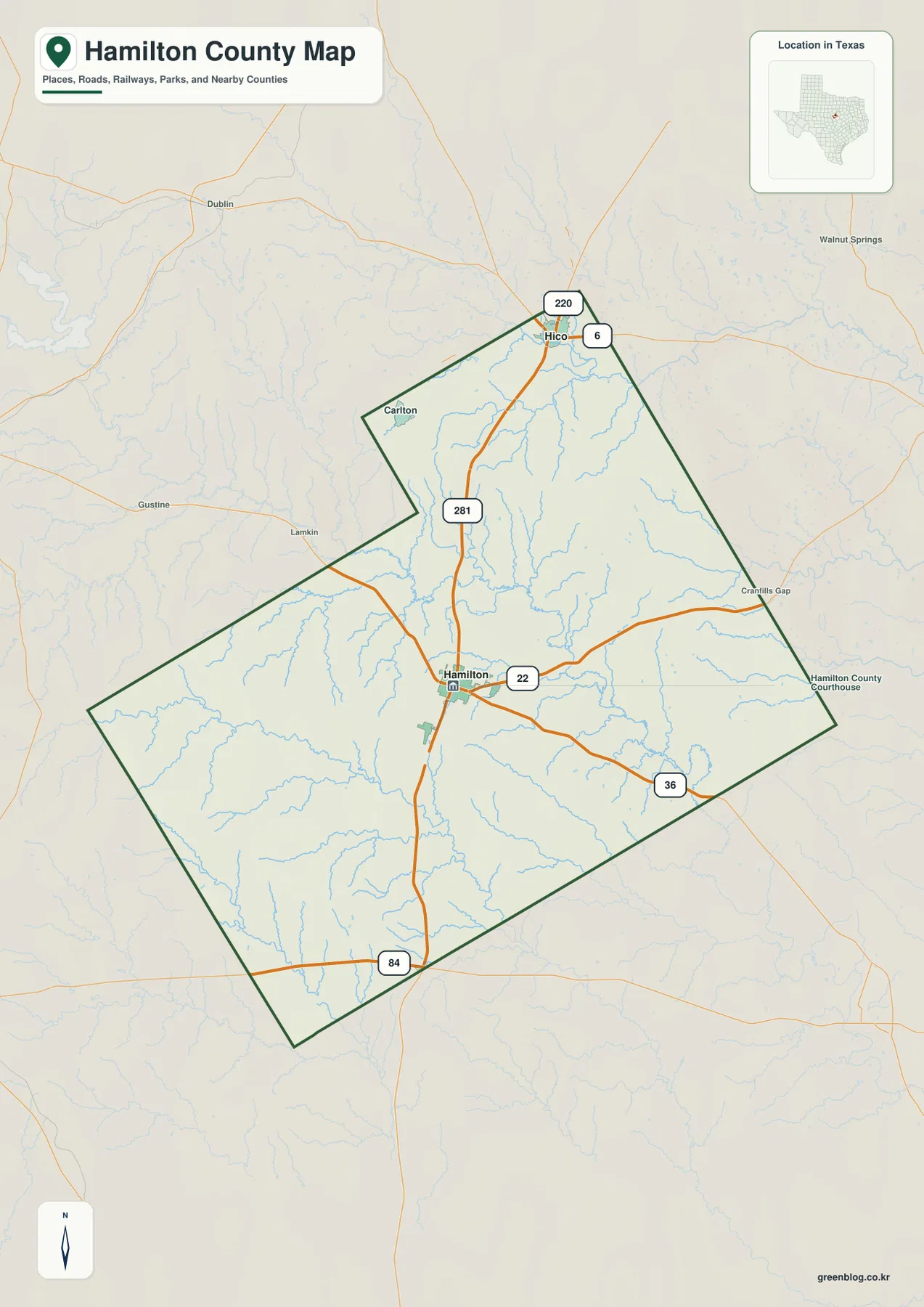
The western and southwestern parts of the county have fewer large road labels than the Hamilton–Hico corridor. That does not mean the area is empty; it means the map is showing a more rural landscape with fewer major urban centers. The irregular western boundary and the long southern side also make the county’s shape easier to recognize than a simple rectangular outline. Once U.S. 281 is fixed in your mind, the positions of Highway 22, Highway 36, and U.S. 84 become much easier to compare.
Leon River and Cowhouse Creek divide the water picture
The Leon River is the dominant named river on the water and terrain map. It runs through the central-eastern part of Hamilton County and bends toward the southeast, collecting a network of smaller tributaries along the way. Honey Creek and Mountain Creek are labeled in the northern half, while Waring Creek, Bear Creek, and Pecan Creek appear closer to the middle. These smaller streams make more sense when they are read as feeders to larger valleys rather than as a list of names.
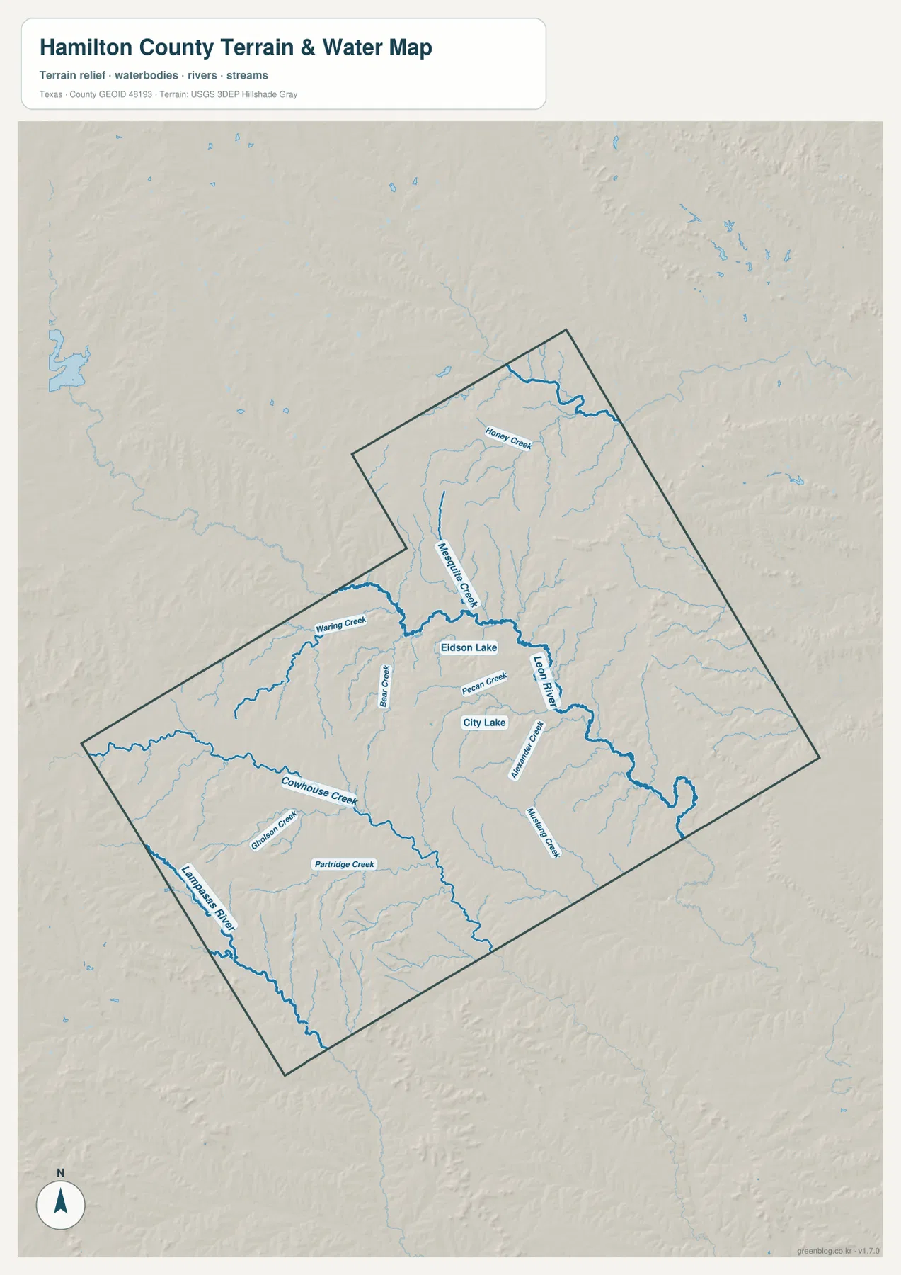
The southwest has a different drainage pattern. Cowhouse Creek runs across a broad section of the western and southern county, while the Lampasas River is visible near the southwestern edge. Gholson Creek and Partridge Creek are also labeled in that part of the map. City Lake and Eidson Lake provide two recognizable water-body references near the central area. Because the map is designed as a geographic reference, it should not be treated as a flood-risk map, a navigation chart, or a legal parcel product.
The combination of shaded terrain and blue waterways also shows why the river names matter. The Leon River occupies a broad lower corridor, and many smaller creeks descend toward it or toward the southern drainage systems. This is especially useful when comparing the water map with the road map: the county’s roads cross a landscape that is cut by numerous creek valleys, even where only a few large towns are labeled.
Elevation falls from the southwest uplands toward the river valleys
The elevation map shows an actual county range of about 259 to 509 meters, with a mean near 369 meters. The highest colors are concentrated in the southwest and along parts of the western side, where ridges and dissected uplands create a rougher appearance. Lower green areas extend through the center and toward the east and southeast. The Leon River valley is especially easy to recognize because the lower terrain forms a long, branching corridor through the county.
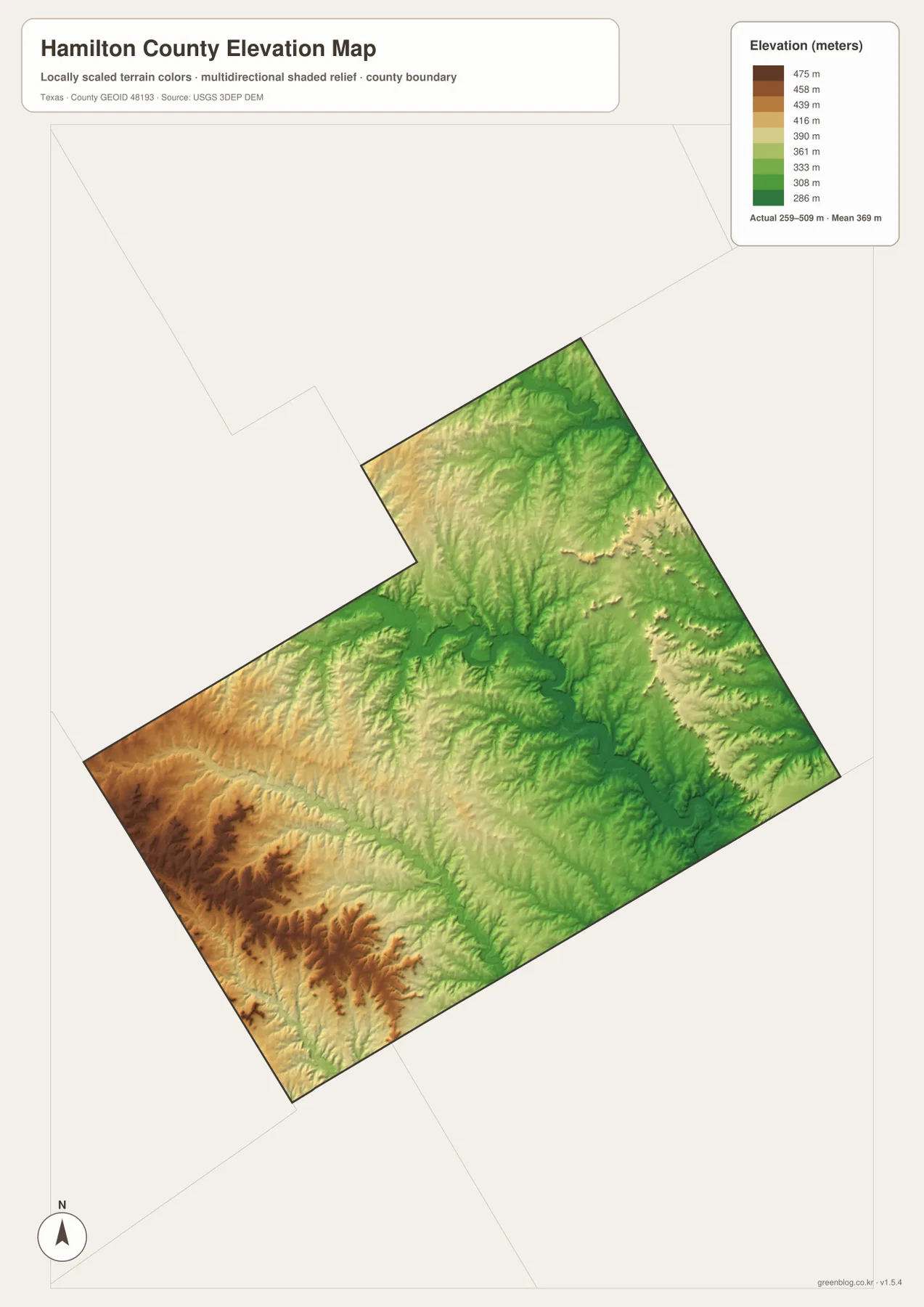
The map is most useful for broad comparison rather than point-by-point measurement. It makes the southwest-to-east elevation change visible at county scale and helps explain why the water map contains so many branching tributaries. The northern area around Hico has its own ridges and valleys, but the strongest concentration of high terrain is farther southwest. For engineering, surveying, or exact site elevations, a dedicated USGS elevation dataset should be used instead of reading a precise number from this generalized surface.
Neighboring counties clarify where each road and valley continues
Hamilton County is easier to place when the neighboring county labels remain visible. Northbound travel near Hico leads toward Erath County and the Bosque County side of the region. East and southeast of Hamilton, the map points toward Coryell County, while Lampasas County lies farther south. Mills and Comanche counties frame the west. These surrounding names are not just decoration: they show which side of Hamilton County a road, creek, or ridge approaches when it crosses the administrative line.
The terrain changes also continue beyond the boundary. Higher ground along the west and southwest does not stop at the county line, and the river systems likewise continue into surrounding areas. That is why the county map, water map, and elevation map work best as a set of references. The boundary tells you where Hamilton County ends, but the roads and natural features explain how the county connects to a larger Central Texas landscape.
Choose the map by the question you need to answer
Use the general county map when you need a quick view of the boundary, Hamilton, Hico, and the main highways. The city map is cleaner when the only question is where the two largest mapped cities sit relative to each other and to neighboring counties. The water map is the better choice for tracing the Leon River, Cowhouse Creek, Lampasas River, City Lake, and smaller tributaries. The elevation map is best when the main task is to compare the high southwest with the lower central and eastern valleys.
For a report, classroom handout, trip-planning reference, or printed location sheet, the four maps can be used separately or compared side by side. The downloadable archive contains the original high-resolution JPG versions corresponding to the body maps. Current road closures, flood conditions, property boundaries, and survey-grade elevations should always be checked against the appropriate official source rather than inferred from these reference maps.
Frequently Asked Questions
Which place should I locate first on the Hamilton County map?
Start with Hamilton because it sits near the center of the county and several important highways meet there. After locating Hamilton, follow U.S. 281 north to Hico. That two-step orientation makes the rest of the county boundary, the east–west roads, and the neighboring counties much easier to place.
What is the clearest difference between the Leon River area and the southwest?
The Leon River occupies a lower corridor through the central-eastern county, while the southwest contains higher terrain and a separate network that includes Cowhouse Creek and the Lampasas River. Comparing the water and elevation maps together makes that contrast especially clear.
What does the elevation map show most clearly?
It shows the broad drop from higher southwest uplands toward lower central and eastern valleys. The supplied legend gives an actual range of about 259 to 509 meters and a mean near 369 meters. Those values are useful for county-scale comparison, not for survey-grade measurements at a specific property.
Sources and Reference Data
For county-specific administrative context, see the official Hamilton County website. Boundary and road/place reference data are available from the U.S. Census Bureau TIGER/Line program. Waterway data can be checked through USGS National Hydrography, and elevation background data are available from the USGS 3D Elevation Program.
Map File Information
Download the original A3 high-resolution JPG versions of the Hamilton County general, city, water, and elevation maps in one ZIP archive.
- File Type: JPG
Related Maps
- Somervell County
- Palo Pinto County Texas map
- San Saba County Texas map
- Navarro County Texas map
- Parker County Texas map
Green Map creates custom-edited map images using open geographic data sources such as geoBoundaries, Natural Earth, OpenStreetMap, and government open data.
These maps are edited visual materials, not raw data files, and are provided for education, documents, presentations, and graphic reference.