This Somervell County Map set uses Glen Rose as the main reference point for roads, streams, reservoirs, and terrain across the county. The general map shows the local road network and county outline, while the water map brings the Paluxy River, Brazos River, Rough Creek, Glen Lake, and several smaller water bodies into focus. The elevation map adds a strong southwest-to-northeast contrast, with high ridges giving way to lower river valleys. High-resolution A3 JPG files are available in the download box below.
Somervell County is small enough that Glen Rose dominates the settlement layer, but the physical landscape is far from simple. A dense set of valleys cuts through the west and south, and the Paluxy River system gathers several branches near the middle of the county. To the east, the Brazos River occupies a broader lower corridor. Reading the maps together makes it easier to understand why roads concentrate around Glen Rose while many of the streams follow winding routes through the surrounding hills.
Table of Contents
Glen Rose is the clearest starting point for the road network
Glen Rose appears slightly northeast of the county’s center and is the strongest landmark on the general reference map. Route 205 approaches the city from the west, while 144 continues south from the Glen Rose area. Routes 412, 403, 411, and 56 help define the southeast side, and 199 and 200 are visible farther northeast. The easiest way to read the map is to locate Glen Rose first and follow the roads outward rather than trying to memorize every route number independently.
Glass is labeled west of Glen Rose, and Seven Knobs appears farther south. Georges Creek is marked near the northeastern side. These smaller labels provide useful geographic reference points even though Glen Rose remains the dominant named settlement. The county outline is also distinctive: long diagonal segments form much of the west and south, while the northern edge bends before turning east. That shape is easier to remember when the roads and waterways are viewed together.
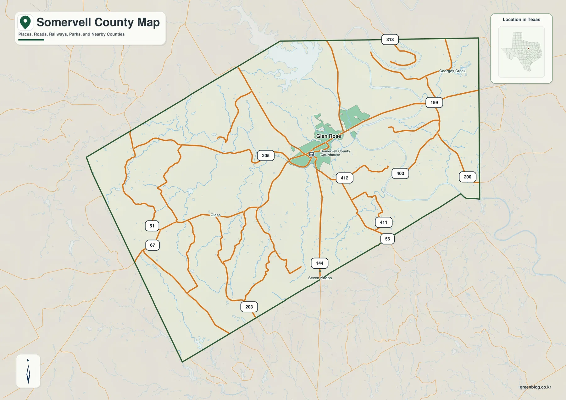
Water features are visible on the reference map, especially toward the north and east, but they are intentionally subdued so the roads remain readable. The terrain-and-water version is therefore a better choice when the goal is to understand the Paluxy River valleys or the relationship between Glen Rose and the larger Brazos drainage.
The city map treats Glen Rose as the single major settlement reference
The ranked city map highlights only Glen Rose. It appears as number 1 near the middle of the county, and the CITY INDEX prints a value of 2,836. Because no second major city is ranked, this view is not intended for comparing multiple urban centers. Instead, it gives a clean picture of where Glen Rose sits inside the county when the road network and secondary labels are reduced.
The simplified layout makes the neighboring county names easier to see. Hood County is labeled to the north, Johnson County to the east, and Erath and Bosque counties appear to the west. These surrounding names help place Somervell County in a broader local frame without distracting from Glen Rose. The CITY INDEX value should be read as the number printed on the supplied graphic; current demographic work should use an official statistical source.
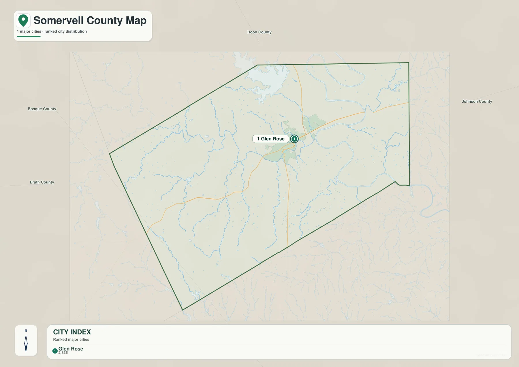
This map works well for a classroom page, county overview, or presentation where one clear settlement marker is more useful than a dense network of road labels. Once Glen Rose is fixed as the main reference, the water and elevation maps become easier to interpret because their river valleys can be related back to a familiar point.
Paluxy River branches meet near Glen Rose before the terrain opens eastward
The terrain-and-water map gives the Paluxy River system the strongest visual role in the center of the county. Rough Creek enters from the west, while the Paluxy River bends across the central interior. White Bluff Creek is labeled near the same drainage area, and Wheeler Branch Paluxy River approaches Glen Rose from the northeast side of the river system. These channels reveal a much more intricate valley network than the road map suggests.
South of the central river corridor, Cross Branch Paluxy River follows a separate valley, and Rock Creek is labeled farther east. The Brazos River appears as the larger watercourse on the eastern side. Several named lakes and reservoirs add smaller reference points: Comanche Creek Reservoir and Panther Branch Lake are near the north, Glen Lake sits close to Glen Rose, and Arena Lake is labeled near the southwest edge. The water bodies are distributed across several parts of the county rather than concentrated in one basin.
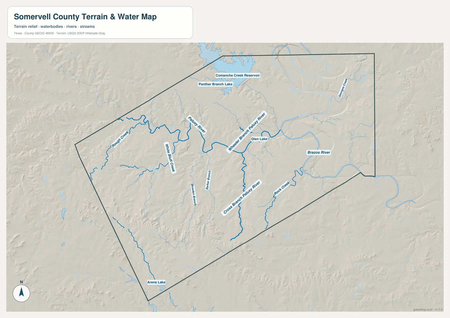
A practical way to read the water map is to begin with the Paluxy River near Glen Rose and then follow the larger drainage east toward the Brazos River. Rough Creek and Cross Branch Paluxy River define additional western and southern valleys. This map is intended for geographic water reference, not flood-risk analysis, parcel boundaries, legal restrictions, or navigation.
High southwestern ridges descend toward the northeastern river valleys
The elevation map reports an actual range of about 166 to 400 meters and a mean elevation of 256 meters. Brown and tan colors dominate the southwest, where the county’s highest terrain forms a broad belt of ridges. Higher ground also extends through the western interior. Moving northeast, those colors shift to yellow-green and then darker green along the wider river valleys.
The southwest is not a single flat plateau. Narrow valleys cut deeply through the high ground, creating repeated ridges and drainage corridors. In the northeast, the lower green terrain becomes broader around the Paluxy and Brazos river systems. Comparing the elevation map with the water map makes the pattern easy to understand: the major streams occupy the lower corridors, while higher hills remain between adjacent drainage lines.
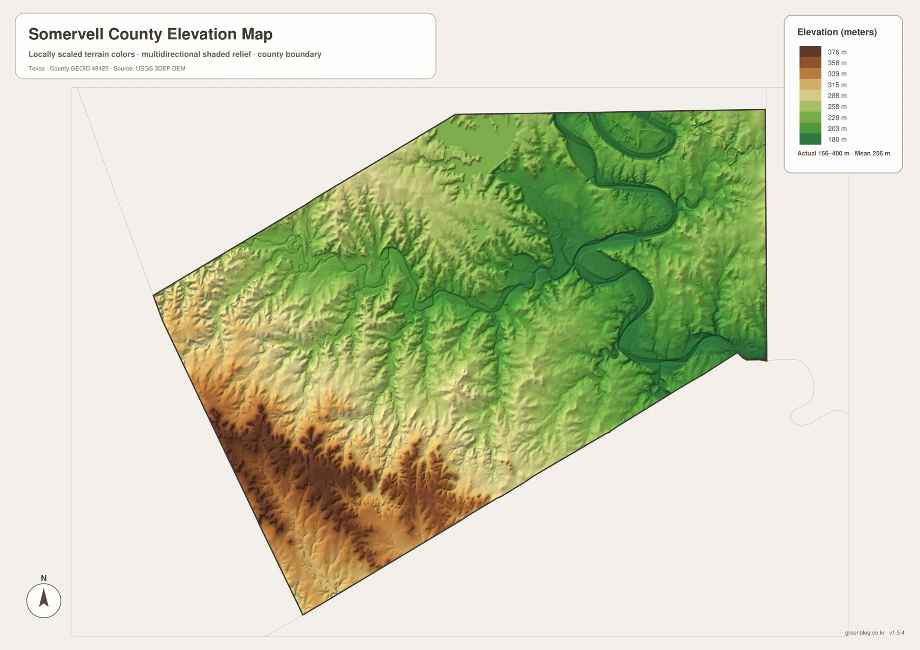
This countywide elevation surface is intended for broad terrain comparison rather than parcel surveying or engineering design. It is useful for seeing which parts of the county are relatively high, where river valleys cut through the ridges, and how the land around Glen Rose differs from the southwestern uplands. Precise site elevation should be checked with detailed source data or a local survey.
Choose the map according to whether location or terrain matters most
Use the county reference map when Glen Rose, local roads, and the county outline need to appear together. The city map is cleaner when Glen Rose alone should stand out. Choose the terrain-and-water map for the Paluxy River, Brazos River, Rough Creek, Glen Lake, and the reservoirs, and use the elevation map when the contrast between southwestern ridges and northeastern valleys is the main subject.
The WebP images in the article are convenient for quick viewing. For printing or editing, the ZIP below contains four matching high-resolution A3 JPG files: county reference, city, terrain and water, and elevation. Because the files remain separate, you can print only the map needed for a classroom handout, local reference page, presentation, or personal project.
Frequently Asked Questions
Where is Glen Rose inside Somervell County?
On the supplied reference map, Glen Rose sits slightly northeast of the county’s center. Route 205 approaches from the west and 144 continues south, making the city the easiest reference point for the local road network.
Does the Paluxy River run near Glen Rose?
Yes. The water map shows the Paluxy River and Wheeler Branch Paluxy River around the Glen Rose area. Farther east, the Brazos River forms a separate larger drainage corridor.
Which part of Somervell County is highest?
The elevation map places the highest brown terrain in the southwest. The Paluxy and Brazos river valleys in the northeast are much lower. The map states an actual range of about 166 to 400 meters and a mean of 256 meters.
Map File Information
The ZIP contains the four Somervell County maps in high-resolution A3 JPG format.
- Included Versions: County reference, city, terrain and water, elevation
- Included Files: 4 A3 JPG maps
Related Maps
Sources and data references
County boundaries and road reference data can be checked through the U.S. Census Bureau TIGER/Line Shapefiles. Rivers, streams, lakes, and reservoirs can be cross-checked with USGS National Hydrography, while elevation data are available through the USGS 3D Elevation Program. The place labels, road numbers, named waters, and elevation figures described above are based on the Somervell County maps supplied in the current ZIP package.
Green Map creates custom-edited map images using open geographic data sources such as geoBoundaries, Natural Earth, OpenStreetMap, and government open data.
These maps are edited visual materials, not raw data files, and are provided for education, documents, presentations, and graphic reference.