You can download the high-resolution A3 JPG Red River County map files from this page in one ZIP archive. Clarksville is the best starting point for understanding the county: U.S. 82 crosses from west to east through the main settlement corridor, while State Highway 37 meets it at Clarksville. Detroit lies to the west, Bogata is farther southwest near the U.S. 271 corridor, and Annona and Avery extend eastward. The maps then add the Red River boundary, named creeks, lakes, and elevation differences so the road-and-town pattern can be compared with the county’s water and terrain.
The county also has a boundary shape that immediately sets it apart from many inland Texas counties. Its northern edge bends with the Red River along the Oklahoma line instead of following a straight survey boundary. Inside the county, Pecan Bayou, Little Pine Creek, Cuthand Creek, Whiteoak Creek, and numerous smaller streams break the landscape into shallow valleys. The elevation surface adds the final piece, showing a range of about 75 to 168 meters with a mean near 122 meters.
The maps are most useful when read as complementary views rather than as four versions of the same picture. The general county map keeps roads, towns, and the boundary together. The city index simplifies the settlement pattern, the water map brings smaller creeks and lakes forward, and the elevation map shows where western uplands give way to lower river and creek valleys.
Table of Contents
Follow U.S. 82 to understand the main settlement corridor
U.S. 82 is the clearest transportation feature on the general county map. It enters from the west near Detroit, passes through Clarksville, and continues east through Annona toward Avery. That sequence gives the county a visible east-west spine, and Clarksville becomes an obvious reference point because State Highway 37 crosses the route there in a north-south direction.
Bogata does not sit directly on that same line. It is southwest of Clarksville and closer to the U.S. 271 corridor, so the western side of the county cannot be reduced to one road. Detroit and Bogata are both west of the county seat, but they approach the central area from different directions. East of Clarksville, the relationship is simpler because Annona and Avery continue along the U.S. 82 corridor.
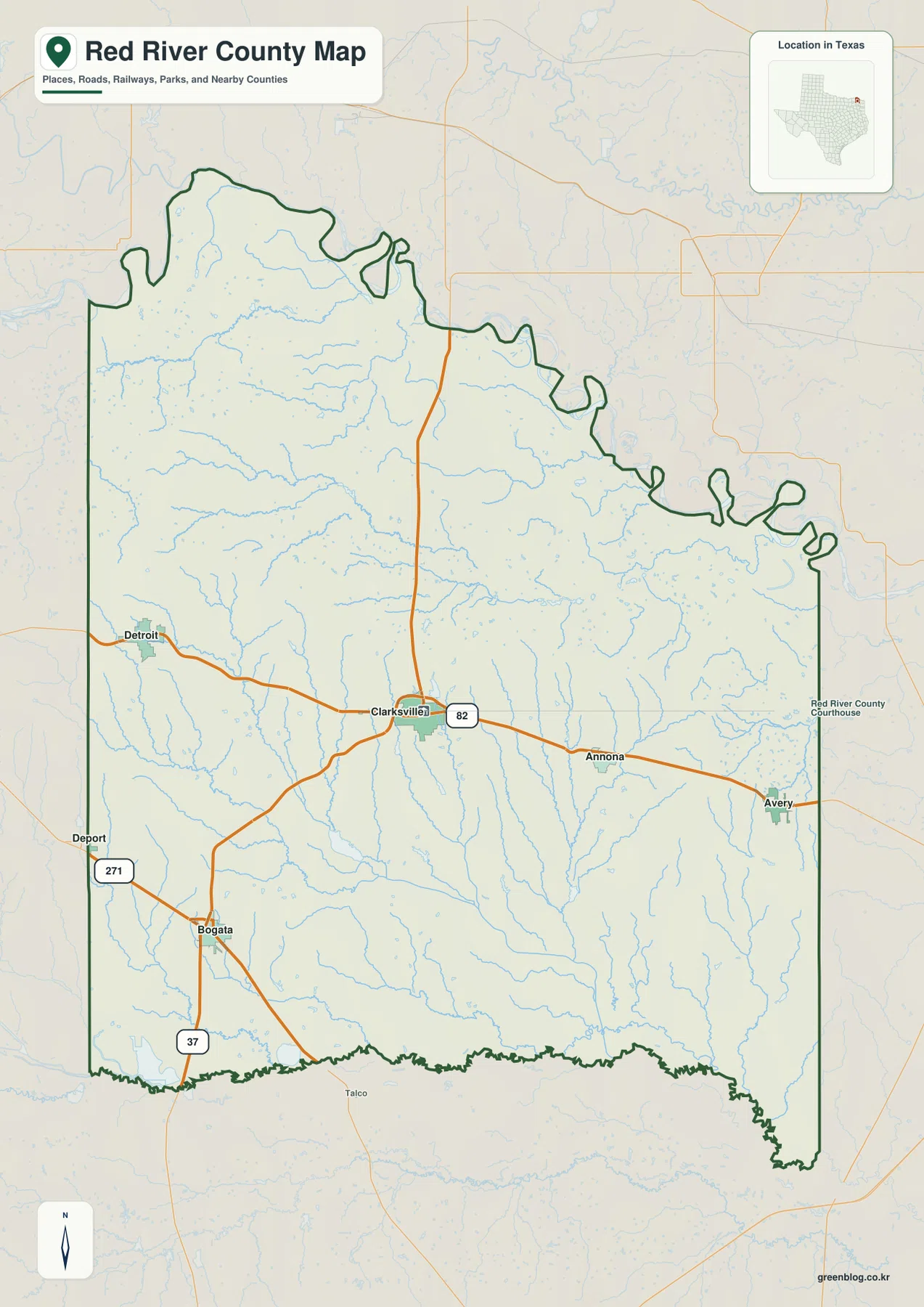
The top edge of the map looks very different from the road network inside it. Instead of a straight line, the northern boundary forms long loops and irregular bends. The Handbook of Texas identifies the Red River as the Texas-Oklahoma boundary in this area, so those bends reflect the river course rather than a cartographic decoration.
This map is therefore best for county-scale orientation: where Clarksville sits, how Detroit and Avery relate to it, and which highways connect the main communities. It is not a parcel map, live navigation service, or property-boundary product. For a reader who needs town names and major roads on one sheet, however, it is the most practical starting map in the set.
The five-place index separates the central seat from east and west towns
The city map highlights Clarksville, Bogata, Avery, Detroit, and Annona without the full road detail of the general map. Its printed comparison panel lists Clarksville at 2,853, Bogata at 804, Avery at 575, Detroit at 573, and Annona at 313. Those numbers belong to the supplied map edition and should be treated as index values on this graphic rather than as a promise of the latest official population count.
The geographic arrangement is more important than the ranking. Clarksville is near the middle, Detroit is to the west, Bogata sits farther southwest, and Annona and Avery form an eastern pair. The pattern makes it clear that the county is not organized around a single isolated settlement. Instead, Clarksville acts as the central seat with smaller communities spread across distinct road corridors.
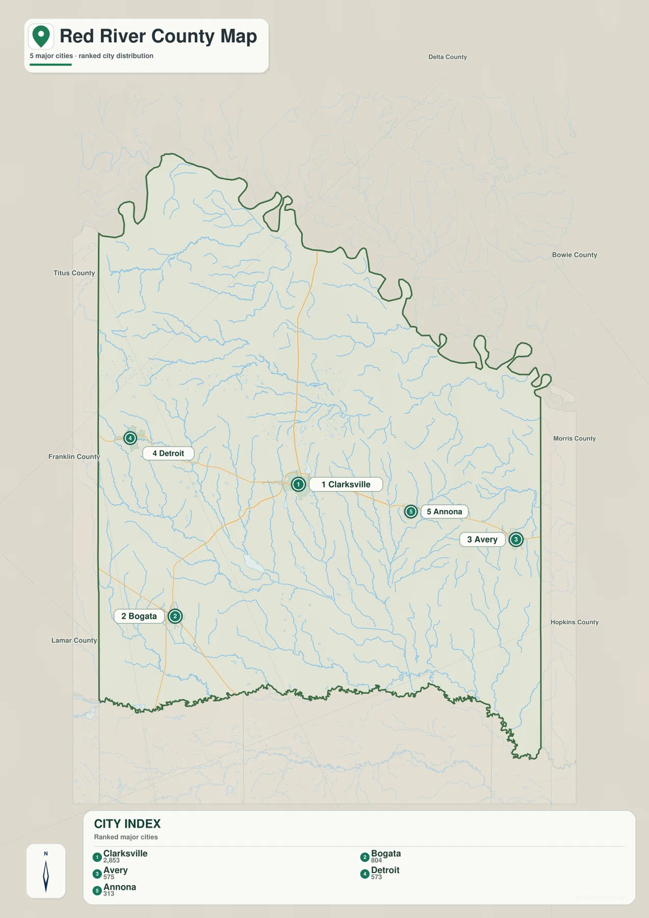
Clarksville’s central role is not only a visual impression. The official Red River County website places the courthouse there, and the Handbook of Texas identifies Clarksville as the county seat. That administrative role aligns with the road map, where U.S. 82 and State Highway 37 meet near the middle of the county.
The city map is especially useful when a road-heavy graphic feels crowded. A reader can first compare the five highlighted places, then return to the general map to see which highway connects them. That two-step approach makes the different positions of Bogata, Detroit, Annona, and Avery easier to remember than trying to follow every road at once.
Small creeks and lakes fill the space between the boundary rivers
The water map contains far more named features than the road-focused map. In the north, labels include Flag Pond, Little Pine Creek, and Pecan Bayou. Around the central part of the county, Country Club Lake, Arrowhead Ranch Lake, Langford Creek Lake, and Brooks Lake appear within a relatively compact area. Cuthand Creek and Mustang Creek stand out toward the southwest, while Whiteoak Creek extends across the southern part of the map.
The lakes are scattered rather than concentrated around one dominant reservoir. T-P Lake, South Lake, Magic Valley Lake, and Humble Lake appear in separate parts of the county, and many smaller tributaries have no large label at all. That distribution gives Red River County a different water-map character from places where one reservoir visually controls the entire page.
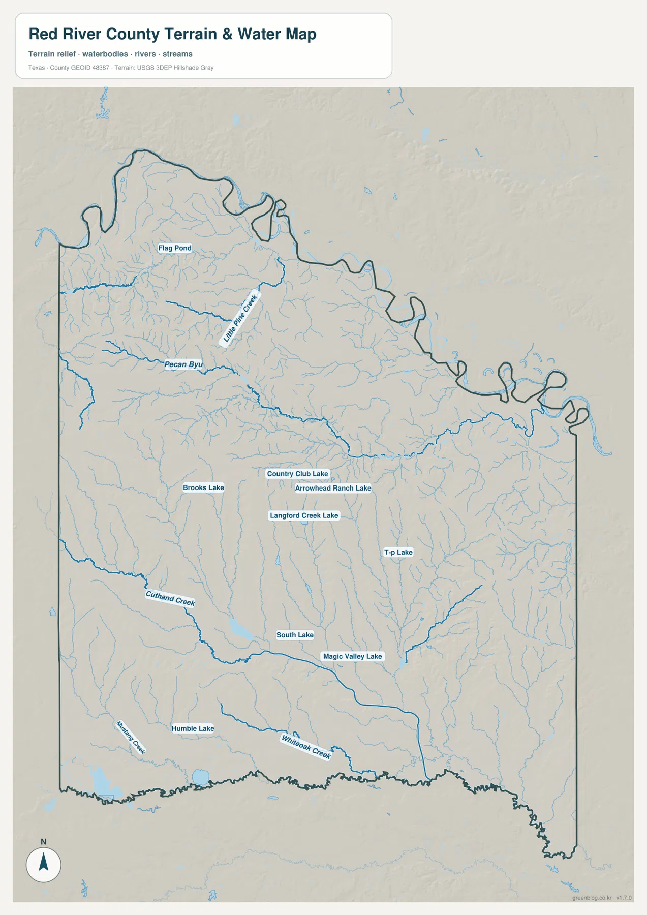
The broader river setting explains the county’s irregular edges. The Handbook of Texas describes the Red River along the north and the Sulphur River along the south. The supplied water map focuses more closely on interior creeks and small water bodies, so using it beside the general county map gives a better sense of how the smaller drainage network sits between those larger boundary rivers.
This is a reference map of named water features, not a floodplain, navigation, ownership, or legal-water-boundary product. A creek shown on the map does not tell a user whether a crossing is passable, whether nearby land is flood-prone, or where a legal property line falls. Those questions require current official information and site-specific sources.
Western uplands step down toward lower river and creek valleys
The elevation map shows a range of roughly 75 to 168 meters and a mean of about 122 meters. Red River County is not mountainous, yet the relief is strong enough to produce a clear color difference across the map. Higher brown and tan areas are concentrated mainly in the west and northwest, while lower green areas follow the northern river edge and spread through much of the east and southeast.
The western high ground is cut by many narrow valleys instead of forming one smooth plateau. When the elevation and water maps are compared, several of those lower channels align with creek systems. The southeast contains broader low areas, while western ridges and slopes are more strongly broken up by drainage lines.
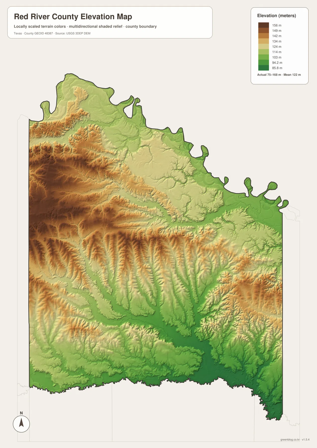
The Handbook of Texas describes the county as gently rolling East Texas country, which fits the map better than any description of steep mountain terrain. The important feature is the repeated transition between low creek valleys and modest ridges. That relief helps explain why the water map contains so many branching streams even though the overall elevation range is not extreme.
The colored surface is appropriate for county-scale comparison only. It should not be used as survey-grade elevation, engineering data, drainage design, or a substitute for site measurement. For exact ground elevation, USGS 3D Elevation Program data and professional surveying sources are more appropriate.
Choose the map by the question, not by the number of labels
Clarksville provides an easy anchor for combining the four views. Start with U.S. 82 and State Highway 37 on the general map, then use the city index to place Detroit and Bogata to the west and southwest and Annona and Avery to the east. After that, the water and elevation maps explain why the land north, west, and southeast of the main town corridor does not all look the same.
For road names and towns together, the general county map is the best choice. The city map is cleaner when the goal is only to compare the five highlighted communities. Use the water map for Pecan Bayou, Cuthand Creek, Whiteoak Creek, and the scattered lakes, and use the elevation map when explaining western uplands, lower river margins, or creek valleys.
Separating the themes also works well for lessons, presentations, or printed reference sheets. A road-and-town page can use the general or city map, while a natural-features page can use the water and elevation maps without crowding every label onto one image. The download package below contains the same four subjects as high-resolution A3 JPG files.
Frequently Asked Questions
Why is the northern Red River County boundary so irregular?
The northern county line follows the Red River along the Texas-Oklahoma boundary, so it bends with the river instead of forming a straight survey line. The general map shows those loops and projections clearly along the top edge.
Which map is best for comparing Clarksville with Bogata, Detroit, Annona, and Avery?
The city map is the quickest choice because it highlights all five places with fewer road labels. If you also need U.S. 82, U.S. 271, or State Highway 37, use the general county map beside it.
Can the 75–168 m elevation map be used for surveying?
No. It is a generalized county-scale surface designed to compare relative highs, lows, ridges, and valleys. Engineering, construction, drainage design, and property surveying require authoritative source data and site-specific measurement.
Sources and Reference Data
For county administration and the courthouse location, see the official Red River County website. County geography and the Red River and Sulphur River boundaries are described by the Handbook of Texas: Red River County, while the separate Clarksville entry provides additional context for the county seat.
For public mapping data programs, see USGS National Hydrography for water features, the USGS 3D Elevation Program for terrain data, and U.S. Census Bureau TIGER/Line Shapefiles for geographic boundaries and related mapping layers.
Map File Information
Download the Red River County maps used on this page as high-resolution A3 JPG files.
- Included Files: county map, city map, water map, elevation map
- File Type: JPG
Related Maps
- Bowie County Texas map | Boston and Red River
- Lampasas County Texas map | Lampasas and Lampasas River
- A Donley County Map
Green Map creates custom-edited map images using open geographic data sources such as geoBoundaries, Natural Earth, OpenStreetMap, and government open data.
These maps are edited visual materials, not raw data files, and are provided for education, documents, presentations, and graphic reference.