Use this Bowie County Map to locate Texarkana, New Boston, De Kalb, the Red River, the Sulphur River, and the main highways across northeast Texas. High-resolution A3 JPG versions of all four maps shown on this page are available in the ZIP download below, so they can be saved for printing, classroom use, or offline reference. Bowie County occupies the far northeastern corner of Texas, with Texarkana on the Arkansas line, New Boston near the middle of the county, and De Kalb serving as a useful western reference. The separate county, city, water, and elevation views make it easier to compare those places with the winding river boundaries and the county’s changing terrain.
A practical way to orient yourself is to find Texarkana first, then follow the main east-west routes toward Hooks, New Boston, and De Kalb. After the settlement pattern is clear, the river and elevation maps explain why the county outline is so irregular and why some parts of the landscape look much more dissected than others. This order also helps distinguish the dense cluster of communities near Texarkana from the more widely spaced towns and rural areas farther west.
Table of Contents
From Texarkana to De Kalb: the county’s east-west corridor
The general county map makes the eastern concentration of roads and communities immediately visible. Texarkana sits against the Arkansas border, with Nash and Wake Village close by and Red Lick just to the north. Moving west, Leary and Hooks appear before New Boston, while De Kalb is separated from the eastern group by a much broader stretch of rural land. Redwater and Maud provide additional reference points in the southern half of the county. This arrangement is more informative than treating Bowie County as a single centered settlement area because its largest urban concentration is pushed to one side of the county.
US 82 is the clearest route for comparing several of these places from west to east, while Interstate 30 forms the major through corridor between the Texarkana area and points farther west in Texas. Near Texarkana, US 59 and US 71 add important north-south connections. US 259 is a useful western reference near De Kalb. Smaller roads branch from those routes toward Maud, Redwater, and other communities, but the main highways give the map a readable framework before the local network is examined in detail.
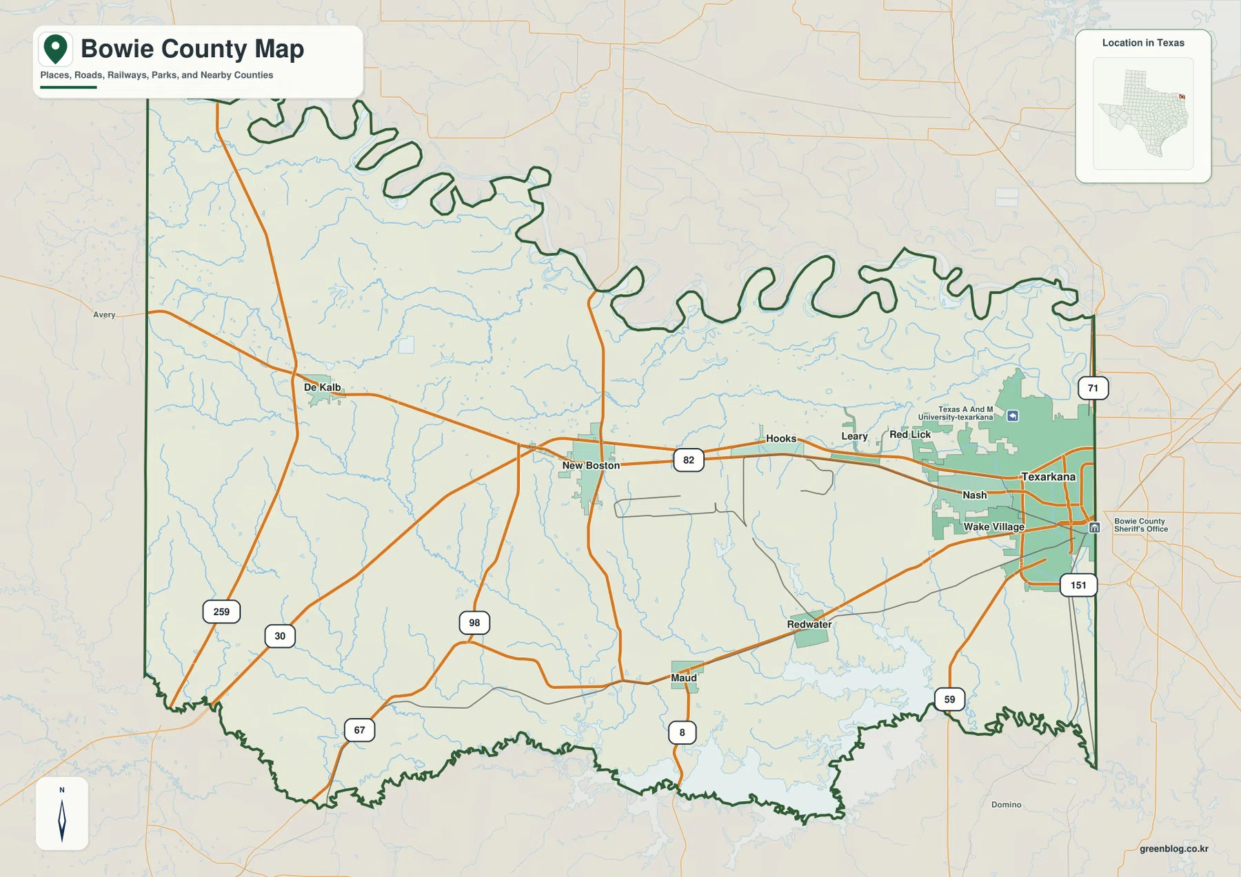
The county boundary is just as distinctive as the road pattern. Red River County lies to the west, Morris County to the southwest, and Cass County to the south. Arkansas is on the east side, with Miller County adjoining the Texarkana area, while the Red River separates Bowie County from areas of Oklahoma and Arkansas along the north. Because the northern line follows the river’s large bends, it looks dramatically different from a straight political boundary. That river-shaped edge is one of the easiest features to recognize when comparing Bowie County with neighboring counties.
Why the largest city cluster is on the Arkansas side
The city-distribution map emphasizes a pattern that can be harder to notice on a road-heavy map. Texarkana ranks first among the six cities shown, and the next locations are Wake Village, New Boston, Nash, Hooks, and De Kalb. Texarkana, Nash, and Wake Village occupy a compact area close to the eastern state line. Hooks stands farther west, New Boston is near the center, and De Kalb is the westernmost of the six. The spacing makes it clear that the county’s principal cities are not evenly distributed across its width.
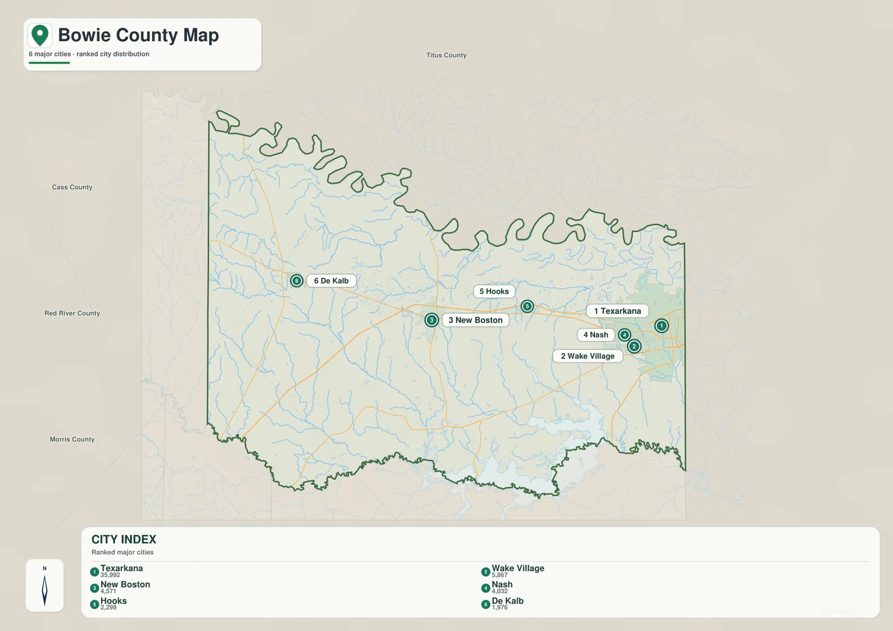
Bowie County also has an unusual county-seat story that matters when reading place names. Boston is the official county seat, but it is a small community immediately south of New Boston and is not one of the prominent ranked cities on this map. The present Bowie County Courthouse is in New Boston even though Boston retains the legal county-seat designation. That distinction explains why a visitor looking only for the largest city or the courthouse can easily assume that New Boston is the official seat. It is better to treat Boston and New Boston as separate but closely related geographic references.
Any straight connector lines on the city view should be read as visual links for comparing positions, not as driving routes or road-mile distances. They are useful for seeing which places belong to the eastern cluster and how far New Boston or De Kalb is displaced from that cluster. For actual travel planning, the road network on the county map is the appropriate reference, because the path between two cities follows the highway system rather than a straight line.
A county framed by the Red River and Sulphur River
Water defines a large part of Bowie County’s outline. The Red River forms the northern edge with a long series of meanders, while the Sulphur River follows much of the southern boundary. Between them is a dense network of smaller creeks, bayous, lakes, and reservoirs. The dedicated water map removes much of the road and city clutter, making those drainage features easier to follow from one part of the county to another.
Several named features stand out on the supplied map. Mud Creek and Red Bayou cross the western and central portions, Anderson Creek runs southward toward the Sulphur River, and Barkman Creek appears in the northeast. McKinney Bayou is close to the eastern boundary. King Lake and Bringle Lake sit near the Texarkana side, while Caney Creek Reservoir and Elliott Creek Reservoir are farther south in the interior. Kennedy Lake appears toward the southeast, and Blackman Lake Number 1 and Number 2 provide smaller references in the northwestern part of the county.
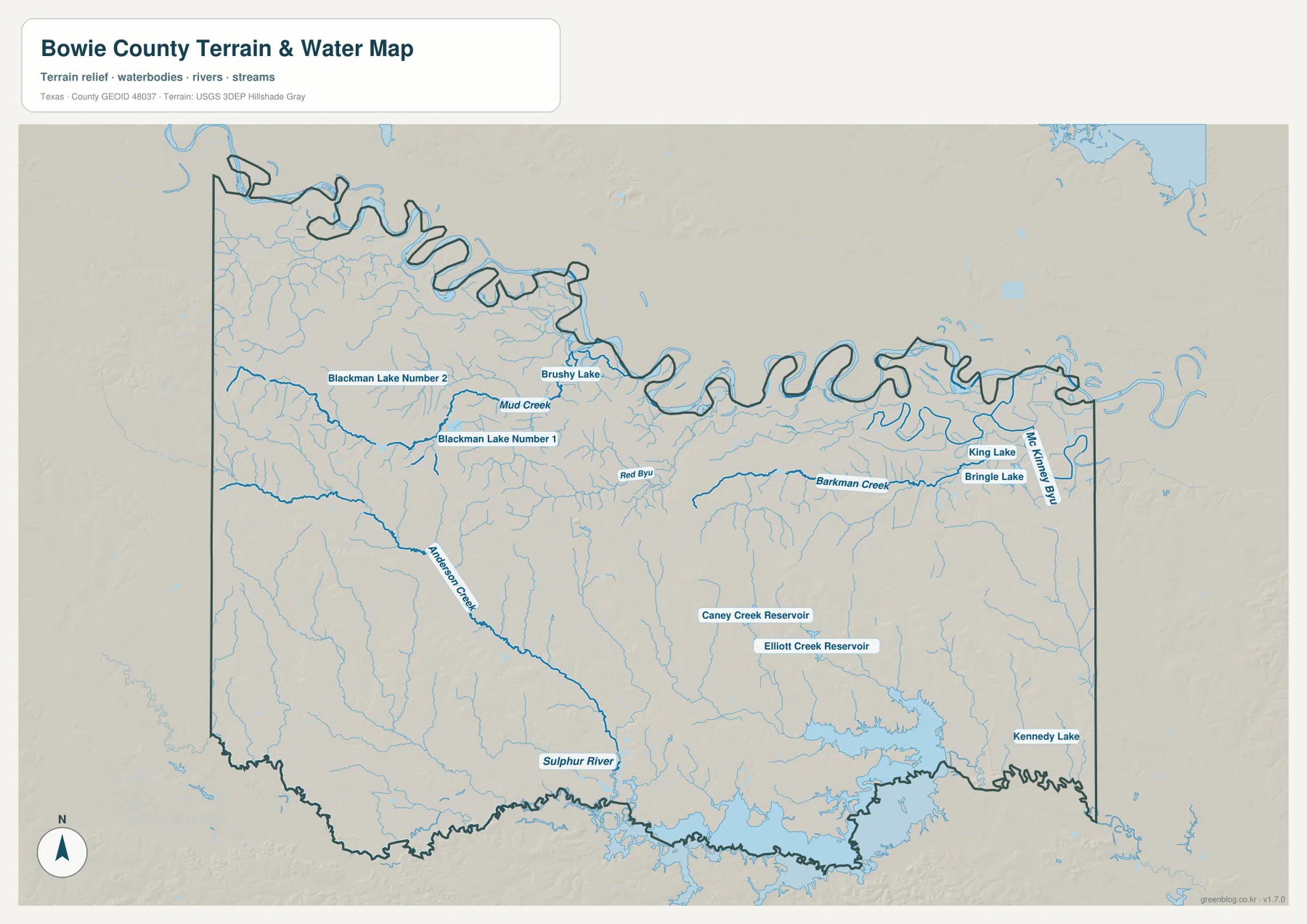
This is a geographic water-reference map, not a flood-risk, parcel, navigation, or legal-water-rights product. Its strongest use is explaining the shape of the county and showing how smaller streams relate to the two major rivers. The highly curved northern boundary closely follows the Red River, and the southern edge also reflects the Sulphur River system. Within the county, the many tributaries help explain the repeated narrow valleys that also appear on the shaded elevation surface.
Higher western ground and lower river valleys
The elevation map shows that Bowie County is gently rolling rather than uniformly flat. The supplied surface reports an actual range of roughly 57 to 150 meters, with a mean near 97 meters. Warmer relief colors are concentrated mainly in the west and northwest, where broad higher areas are cut by numerous small valleys. Lower green tones are common along the Red River margin and across many stream corridors in the south and east.
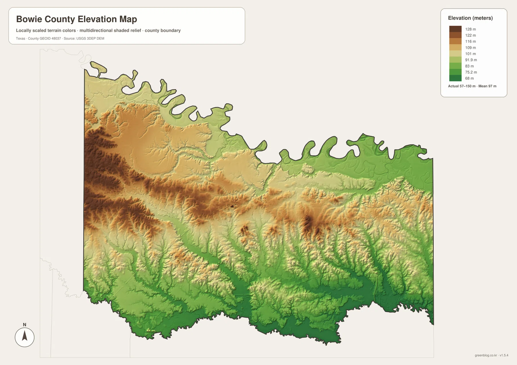
The transition is gradual rather than a sharp step from west to east. In the central part of the county, narrow valleys extend through otherwise higher ground, and the southern half contains many branching low corridors that correspond with the creek network. The eastern side near Texarkana is generally lower than the broad western uplands, although local ridges remain visible. Reading the elevation and water maps together makes the relationship especially clear: many of the green, lower strips line up with streams or larger river valleys.
The elevation layer is intended for broad landscape comparison. It should not be used as survey-grade or engineering-grade elevation for a property, construction project, drainage design, or other site-specific work. For classroom use, regional planning at a general scale, or a geographic overview, however, it provides an effective picture of where the county rises and where water has cut lower routes through the terrain.
Choosing the right Bowie County view
For locating a town, checking the state and county edges, or following the major highways, start with the general county map. The city view is better when the question is simply how Texarkana, Wake Village, New Boston, Nash, Hooks, and De Kalb are positioned relative to one another. The water map is the most useful choice for named creeks, bayous, lakes, reservoirs, and the river boundaries. The elevation map answers a different question by showing which areas are higher and how valleys cut across the county.
Using two maps together often produces a clearer answer than trying to force one map to do everything. If New Boston is your reference point, first use the road map to locate US 82 and Interstate 30, then check the water map for nearby drainage features, and finally compare the surrounding valleys and uplands on the elevation surface. Around Texarkana, begin with the state line and dense road network, then move to Bringle Lake, King Lake, McKinney Bayou, and the lower terrain toward the eastern side. These combinations keep the geographic explanation tied to actual named features rather than generic map-reading advice.
Reading Bowie County as a three-state corner region
Bowie County’s position is unusual within Texas because the eastern and northern edges connect directly with another state or with a river boundary facing another state. Texarkana is divided at the Texas-Arkansas line, and Interstate 30 crosses that line almost immediately east of the city. Farther north, the Red River separates the county from Oklahoma and Arkansas areas. The result is a county whose everyday map context extends beyond Texas, so a map cropped too tightly to the county line can hide an important part of its geography.
Reliable regional references describe Bowie County as part of the East Texas Timberlands, with level to gently rolling terrain drained by the Red and Sulphur rivers. The supplied maps fit that description well without needing technical terminology: the western half contains broader higher ground, the river margins are lower, and the county is crossed by many creek valleys. The eastern urban concentration around Texarkana also reflects the importance of the state-line location and the major highway junction there. These are county-specific relationships that become much easier to see when the road, water, and relief views are compared side by side.
Frequently Asked Questions
Is Boston or New Boston the county seat of Bowie County?
Boston is the legal county seat of Bowie County. It is a small community immediately south of New Boston, while the current Bowie County Courthouse is in New Boston, which is why the two names can be confusing on city and road maps.
How do the Red River and Sulphur River relate to the county boundary?
The Red River forms the winding northern edge of Bowie County, while the Sulphur River follows much of the southern boundary. The water map is the clearest place to compare those two river edges with smaller creeks, bayous, lakes, and reservoirs inside the county.
Which map is best for comparing Texarkana and New Boston?
Start with the city map for a quick position comparison, then use the general county map to follow US 82 and Interstate 30 between the two areas. Any straight connector lines on the city view are visual aids rather than driving routes or road-mile distances.
Sources and Reference Data
- Texas State Historical Association – Bowie County: county-seat history, regional setting, rivers, terrain, and community background.
- U.S. Census Bureau TIGER/Line Shapefiles: official geographic files used for boundaries, roads, and related map features.
- USGS National Hydrography: authoritative U.S. water-feature and hydrography information.
- USGS 3D Elevation Program: official information about national elevation data and terrain products.
Map File Information
Download the map files associated with this page for reference, printing, and compatible visual projects.
- Included Files: Use only the versions confirmed in the article and supplied images
- File Type: Use the confirmed download contents
- Intended Use: Printing, education, presentations, and map-based projects
Related Maps
Green Map creates custom-edited map images using open geographic data sources such as geoBoundaries, Natural Earth, OpenStreetMap, and government open data.
These maps are edited visual materials, not raw data files, and are provided for education, documents, presentations, and graphic reference.