This Graham County, North Carolina map page pairs clear on-screen previews with a ZIP download of the matching A3 high-resolution JPG files. Robbinsville is the county seat and the easiest starting point, but the county’s geography quickly pulls attention toward Lake Santeetlah to the northwest, Fontana Dam near the northern edge, and the Cheoah and Little Tennessee river systems. The main county view keeps roads, boundaries, and major place names together, while the other views make it easier to compare a few key locations or focus on rivers and mountain drainage. If you need a printable or document-ready copy, the downloadable JPG files match the maps shown in the article rather than introducing a different set of layers.
Graham County lies along the Tennessee line in North Carolina’s far western mountains. Cherokee County is on the west and southwest, Macon County is to the southeast, and Swain County is on the east. NCpedia records that the county was formed from Cherokee County in 1872 and names Robbinsville as the county seat; it also notes that much of the county is covered by Nantahala National Forest. That background fits the maps well. Settlement labels occupy relatively small pockets, reservoirs take up broad areas, and the main roads bend through valleys instead of forming the straight grid common in flatter counties.
Table of Contents
A western North Carolina county framed by mountains and the Tennessee line
The county outline encloses a compact piece of the southern Appalachian mountains, but the interior is anything but simple. Robbinsville sits south of center, Lake Santeetlah is northwest of town, and Fontana Dam marks a useful northern reference near the Tennessee boundary. Those locations give the eye three anchors before the smaller roads and tributaries come into view. They also make clear why Graham County is easier to understand as a combination of valleys, reservoirs, and mountain routes than as a town-centered road network.
The outline is irregular, especially along the northern side where the Fontana Lake and Little Tennessee River system creates a complicated edge. The western and southern boundaries also bend through mountainous country rather than forming a simple rectangle. On a statewide map, Graham County can look small, but the local map reveals how much of its interior is occupied by ridges, valleys, and drainage lines. This makes county-level orientation particularly useful for visitors who know the names Robbinsville or Fontana but are less familiar with how those places relate to the Tennessee border and neighboring North Carolina counties.
Nantahala National Forest is an important part of that setting. NCpedia describes much of Graham County as national forest, including the Joyce Kilmer Memorial Forest area in the west. U.S. Forest Service planning material for the Fontana Lake geographic area likewise emphasizes the mountain valleys and reservoirs created by dams on the Little Tennessee and Cheoah river systems. Those official descriptions match what is visible on the supplied maps: settlement labels occupy relatively small areas, while water and mountain terrain provide the broader framework for understanding the county.
US 129, NC 143, and NC 28 provide the main road references
Robbinsville is the best place to begin reading the general county map because several routes can be compared from there. US 129 runs through the Robbinsville area and continues toward the southeastern side of the county. NC 143 reaches westward across mountain country and provides a useful road reference for the Lake Santeetlah side. NC 28 appears farther north near Fontana Dam and the upper reservoir landscape. None of these routes behaves like a straight urban corridor. They curve with valleys, streams, and mountain slopes, which is one of the most important things the county map communicates.
Lake Santeetlah sits northwest of Robbinsville and has an irregular shoreline that reaches into the surrounding terrain. North of both places, Fontana Dam gives the map another strong landmark where the road system and a major body of water come together. If the goal is to explain where Robbinsville is in relation to the county’s better-known natural features, following these roads is more helpful than measuring a straight line across the map. The map is not a turn-by-turn navigation product, but it works well for understanding which direction the larger routes take before a detailed road map or navigation service is used.
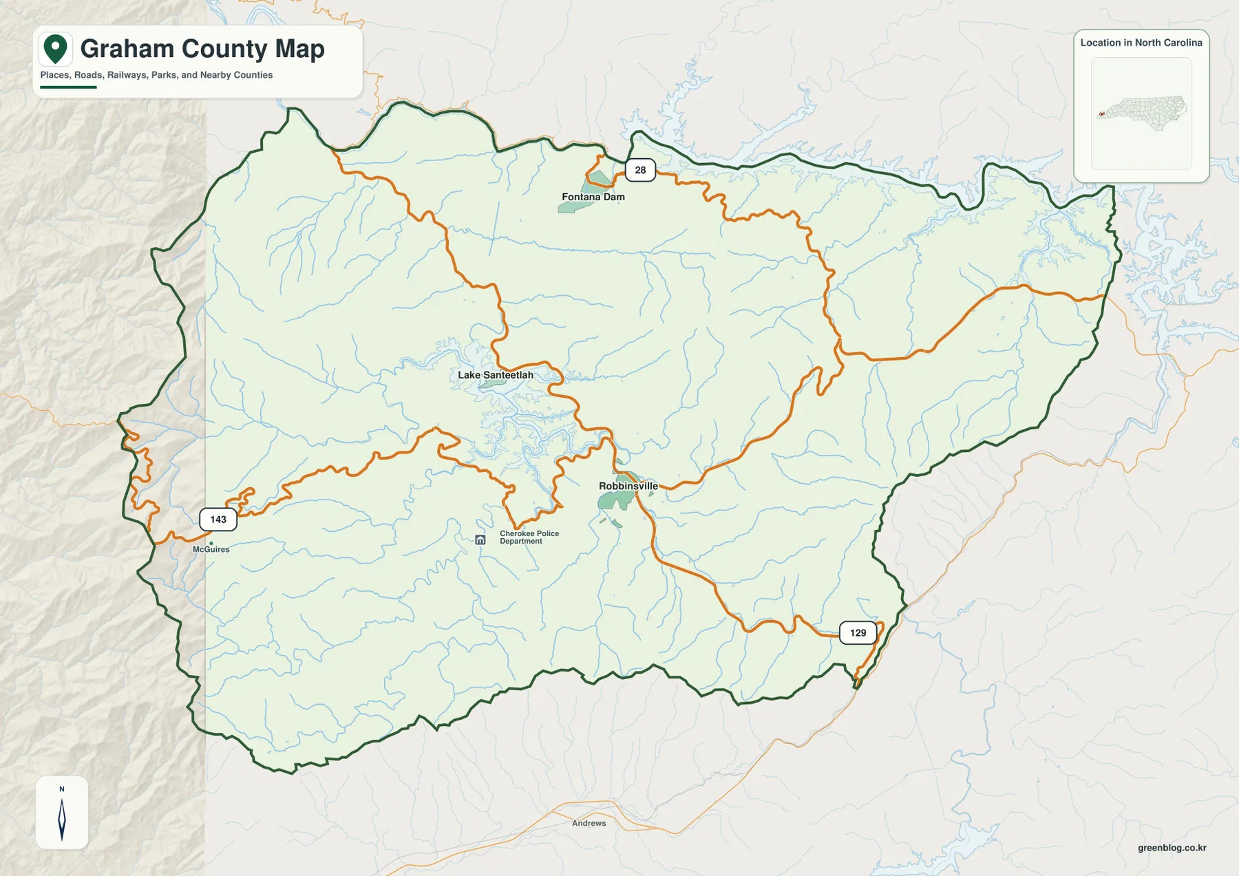
The general map also includes smaller reference labels and nearby terrain outside the county outline. These should be treated as orientation aids rather than a complete inventory of communities or facilities. In a mountainous county, the spaces between labels are meaningful: they often represent forested slopes and valleys where the road network is sparse compared with a metropolitan area. Looking at how the road lines bend around Lake Santeetlah and follow the broader drainage pattern gives a more realistic impression of travel and settlement than counting the number of town names on the page.
Robbinsville as the hub for Lake Santeetlah and Fontana Dam
The city-connections view strips away most of the smaller labels so the relationship among Robbinsville, Lake Santeetlah, and Fontana Dam stands out. Lake Santeetlah is plotted northwest of Robbinsville, and Fontana Dam lies farther north. The legend shows about 4 miles from Robbinsville to Lake Santeetlah and about 8 miles from Robbinsville to Fontana Dam by direct distance. Those numbers are straight-line references between mapped points, not driving mileage, which is an important distinction in a county where ridges, reservoir arms, and winding roads often force a longer route.
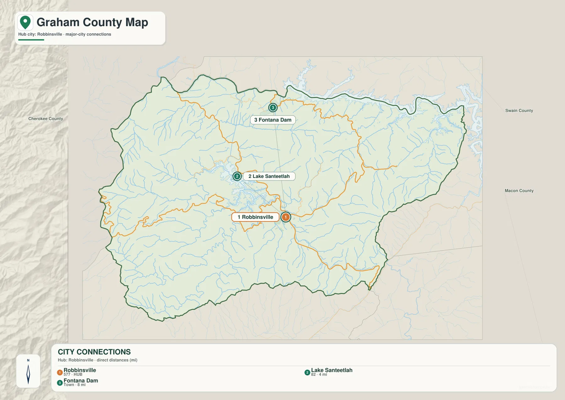
With the smaller road labels removed, the map works especially well for explaining direction. Lake Santeetlah appears close to Robbinsville but in a separate reservoir-and-mountain setting, while Fontana Dam gives the northern part of the county a clear anchor. Cherokee, Swain, and Macon counties are labeled outside the boundary, so the three highlighted points can also be placed within the wider western North Carolina setting. A presentation that only needs the basic arrangement can use this view without asking readers to sort through every creek or local road.
Because this view highlights only three reference points, it is not meant to be a complete list of Graham County communities. Robbinsville is included because it is the county seat and the main road reference on the page; Lake Santeetlah and Fontana Dam are included because they mark two distinct parts of the county where water and mountain terrain dominate the landscape. The limited labeling keeps the direction and distance information readable without implying that all three places have the same administrative role.
The Cheoah and Little Tennessee systems organize much of the county’s water map
Water becomes the main organizing feature in the terrain-and-water view. The Little Tennessee River and the broad Fontana reservoir system define much of the north, while the Cheoah River crosses the central part of the county and connects the Lake Santeetlah area with the larger northern watershed. Santeetlah Creek enters from the west, and Snowbird Creek with Little Snowbird Creek stands out in the southwest. Once those larger names are located, the many smaller tributaries make more sense as streams descending through narrow mountain valleys.
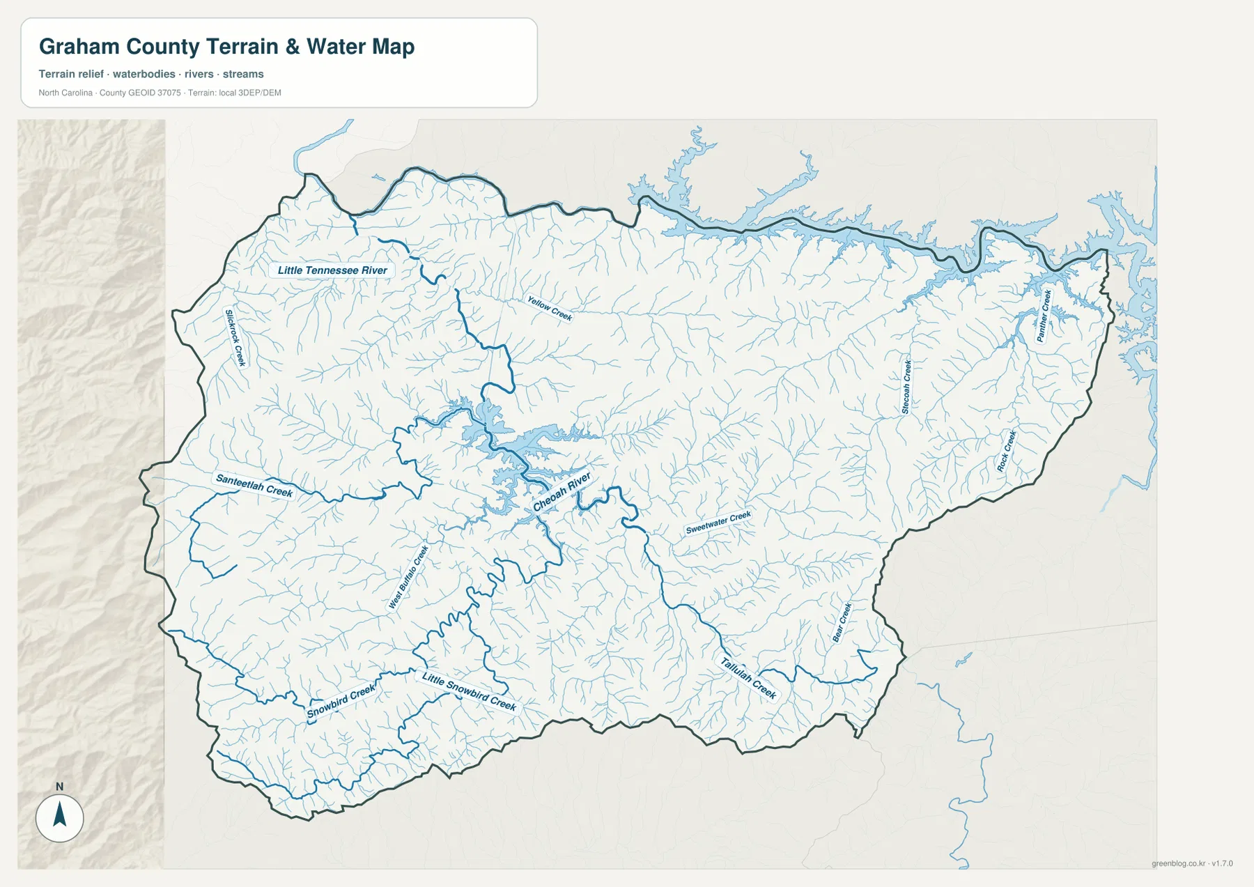
Several additional streams help distinguish the eastern and southern parts of the county. Stecoah Creek and Panther Creek appear toward the east, while Sweetwater Creek, Bear Creek, and Tallulah Creek are labeled farther south. Slickrock Creek is visible near the western boundary. The point is not to memorize every creek name, but to see how closely the drainage network follows the terrain. In a mountainous county, streams often occupy the same valleys that guide roads and settlement, so the water map can explain why the general road map bends and branches the way it does.
Official sources reinforce the importance of these water bodies. Tennessee Valley Authority material describes Fontana Reservoir as an impoundment of the Little Tennessee River created by Fontana Dam and located in both Graham and Swain counties. U.S. Forest Service planning material for the Fontana Lake area discusses the lakes formed by dams on the Little Tennessee and Cheoah rivers and identifies Lake Santeetlah as a major feature south of Fontana Lake near Robbinsville. The supplied map does not need those background facts to show the waterways, but the sources help explain why the northern reservoir and the central Cheoah system are such strong geographic references.
The water view is intended for geographic reference, not for flood-hazard decisions, boating navigation, property boundaries, or water-depth measurements. Its shaded terrain helps explain why streams occupy certain valleys, but the background should not be treated as survey-grade elevation data. It is most useful for locating rivers, creeks, reservoirs, and the valleys around them; engineering, flood insurance, dam operations, and legal boundary questions require the appropriate specialized official source.
Why a short map distance can mean a much longer mountain drive
The difference between straight-line distance and road distance is one of the most practical lessons in the Graham County maps. Lake Santeetlah is shown only about four direct miles from Robbinsville, yet the shoreline, slopes, and curving roads prevent a simple straight route. Fontana Dam is about eight direct miles from the hub on the city-connections map, but reaching the northern part of the county requires following roads that conform to mountain valleys and reservoir edges. The distance labels are therefore excellent for orientation but should never replace current driving directions.
The general county map helps explain the difference. Roads repeatedly change direction near water and steep terrain, while the water map reveals dense tributary valleys between the principal destinations. Two points may look close when measured across a ridge, but the usable road may have to descend one valley, cross near a stream, and climb or curve into another. The opposite can also happen when a broad valley gives a road a relatively direct passage. This relationship between terrain and access is more informative than a simple mileage table when describing Graham County to someone unfamiliar with western North Carolina.
Fontana Lake makes the contrast especially clear. Long reservoir arms reach into the northern landscape, and the county boundary follows a complicated edge around water and mountains. A point on the opposite side of a reservoir arm may be geographically close but not directly accessible by road. Lake Santeetlah has a similarly irregular shoreline on a smaller scale. For classroom use, these maps offer a good example of why physical geography influences transportation even when modern roads connect the main communities.
Matching the map to roads, place relationships, or waterways
The best map depends on what the reader needs to explain. For a broad county overview, the boundary-and-road view keeps Robbinsville, US 129, NC 143, NC 28, Lake Santeetlah, Fontana Dam, and the county outline in one frame. A presentation focused only on where the highlighted places sit relative to Robbinsville is cleaner with the city-connections view. When rivers, reservoirs, or mountain drainage are the subject, the terrain-and-water image adds the Cheoah River, Little Tennessee River, and named creeks without crowding the road map with extra labels.
Splitting those jobs among the three images keeps Graham County’s dense stream network and winding roads legible. One image can introduce the county, another can simplify the relationship among the three highlighted places, and the water view can carry the detailed creek names. That makes it easier to choose a map for a school project, regional profile, presentation, or general reference without treating any of the images as a substitute for parcel records, engineering surveys, hazard maps, or live navigation.
The ZIP download contains the three A3 high-resolution JPG files that correspond directly to the WebP previews on the page. Those JPG originals are the better choice for saving locally, placing in a document, or printing at a larger size while keeping the original proportions. There is no separate elevation, land-cover, flood, or parcel map in this package; the downloadable set is limited to the county boundary-and-road map, the city-connections map, and the terrain-and-water map shown above.
- County map: best for Robbinsville, major routes, Lake Santeetlah, Fontana Dam, county boundaries, and a general geographic overview.
- City-connections map: best for comparing the direction and straight-line distance from Robbinsville to Lake Santeetlah and Fontana Dam.
- Terrain and water map: best for the Cheoah River, Little Tennessee River, major creeks, reservoirs, and the mountain drainage network.
Frequently Asked Questions
How far is Lake Santeetlah from Robbinsville on the map?
The city-connections map shows Lake Santeetlah about 4 miles from Robbinsville by direct distance. That number is a straight-line reference between mapped points, not a driving distance. Mountain roads curve around slopes and water, so actual travel can be longer. Use the map to compare direction and relative closeness, then check a current navigation service or road map for a trip.
Why are Fontana Dam and Fontana Lake useful reference points for Graham County?
Fontana Dam gives the northern part of the county a clear landmark where NC 28, the Little Tennessee River system, and a large reservoir come together. TVA identifies Fontana Reservoir as an impoundment of the Little Tennessee River extending through Graham and Swain counties. On the map, that makes Fontana Dam and the reservoir useful for explaining the northern boundary and the relationship between Graham County’s roads and waterways.
What files are included in the Graham County download ZIP?
The ZIP contains three A3 high-resolution JPG files: the county boundary-and-road map, the city-connections map, and the terrain-and-water map. The WebP images on the page are optimized for quick viewing, while the JPG files are intended for saving, document use, and printing. A separate elevation, land-cover, flood, or parcel map is not part of this download.
Map File Information
Download one ZIP with the three A3 high-resolution JPG originals that match the Graham County map previews shown above.
- Included Files: county map, city-connections map, terrain and water map
- File Type: JPG
Related Maps
Sources and References
- Graham County Government — official county information and government reference for Robbinsville.
- NCpedia – Graham County — county formation, county seat, neighboring counties, and regional background.
- Tennessee Valley Authority – Fontana Reservoir — official background on Fontana Dam, the Little Tennessee River, and the reservoir.
- U.S. Forest Service – Nantahala and Pisgah National Forests Plan — regional background on Fontana Lake, Lake Santeetlah, and surrounding national forest lands.
- USGS National Hydrography — official hydrography reference for rivers and streams.
- U.S. Census Bureau TIGER/Line Shapefiles — official boundary and geographic reference data.
Green Map creates custom-edited map images using open geographic data sources such as geoBoundaries, Natural Earth, OpenStreetMap, and government open data.
These maps are edited visual materials, not raw data files, and are provided for education, documents, presentations, and graphic reference.