Jenkins County is in eastern Georgia, with Millen serving as the county seat and the main point where local roads, rural communities, and regional travel routes come together. This page provides four complementary map views: a county reference map, a city-focused map, a water map, and an elevation map. Together they show the county boundary, Millen, neighboring counties, major numbered routes, the Ogeechee River and its tributaries, and the change from lower river corridors to higher rolling ground. Lightweight WebP previews are shown on the page, while the downloadable ZIP contains four original high-resolution A3 JPG maps.
Millen is the most useful starting point for reading the county. The city sits near the middle of the mapped road network and close to the Ogeechee River–Buckhead Creek system. North of Millen, the county extends toward Perkins and the Magnolia Springs area; to the east and west, roads continue into neighboring counties and smaller rural communities. Looking at the road, water, and elevation maps together makes it easier to see why the county does not function as a single flat grid. Roads concentrate around Millen, streams follow lower ground, and higher ridges appear away from the main river corridor.
These maps are designed for geographic reference, classroom use, local-history research, trip preparation, reports, and general orientation. They are not substitutes for turn-by-turn navigation, parcel records, flood-hazard maps, or engineering surveys. The best approach is to choose the map that matches the question you are trying to answer, then use an official specialized source when legal boundaries, current road conditions, flood risk, or site-level elevation is required.
Table of Contents
Jenkins County Boundary and Its Place in Eastern Georgia
The county reference map gives the clearest overview of Jenkins County as a whole. A dark boundary line separates the county from its surroundings, while the inset places it within Georgia. The larger map also shows nearby counties and communities, which is useful because a county outline by itself can make local geography feel isolated. Burke County lies to the north, Screven County to the east, Emanuel County to the west, and Bulloch and Candler counties are shown toward the southern and southwestern side of the surrounding area.
Millen appears near the center of the road network. Perkins is marked north of the city, and the historical Habersham label appears farther north. Outside the county boundary, places such as Sardis, Rocky Ford, Garfield, Twin City, and Portal provide additional orientation. Those surrounding labels are especially helpful when a road leaves Jenkins County, because the map shows the direction in which the route continues rather than ending the visual context at the county line.
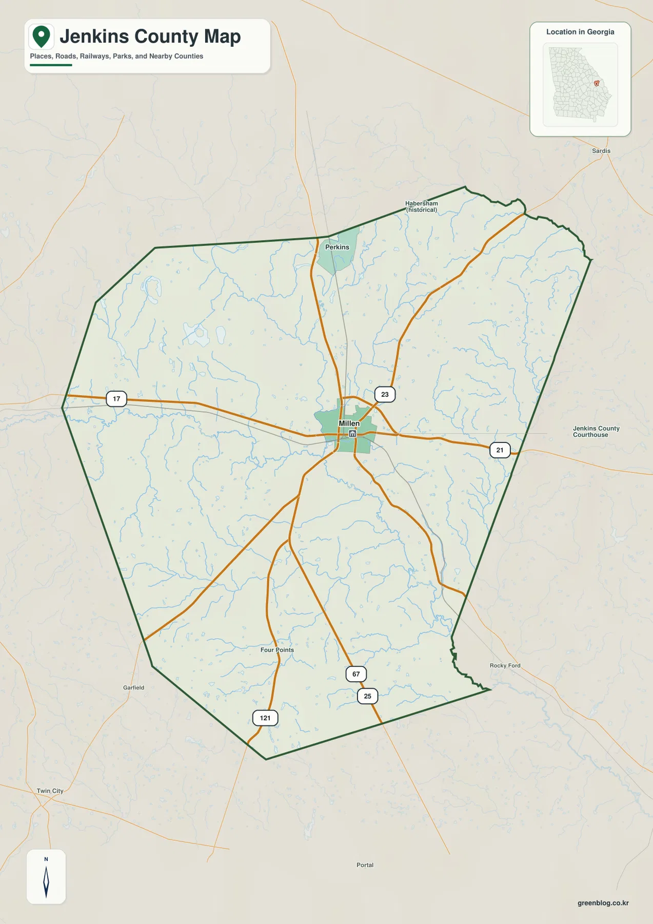
The road pattern explains why Millen stands out so clearly. Georgia Department of Transportation sources identify U.S. 25 as an important north–south route through the county, while State Route 17 crosses Millen in an east–west direction. Routes 21, 23, 67, and 121 also connect the city with different parts of Jenkins County and the surrounding region. Some of these route numbers share corridors for part of their length, so the map is most useful for understanding the county-wide layout rather than memorizing every concurrency or turn. For current driving directions and construction conditions, a live transportation source should still be used.
Millen as the County’s Main Urban and Road Center
The city map simplifies the county so that Millen becomes the main visual reference. The map’s city index identifies Millen as the major city shown, while the county boundary and surrounding county labels remain visible. This is a useful presentation for visitors who do not need every small community name but want to understand where the county seat sits in relation to the rest of Jenkins County.
Millen’s role as a transportation center has a historical basis. The New Georgia Encyclopedia describes how nineteenth-century railroad connections helped shape the settlement and how Millen later became the governmental and commercial center of Jenkins County. That background still makes sense when looking at the modern map: several numbered roads radiate from or pass close to the city, creating direct links north toward Perkins, east toward Screven County, west toward Emanuel County, and south toward the rural portions of the county.
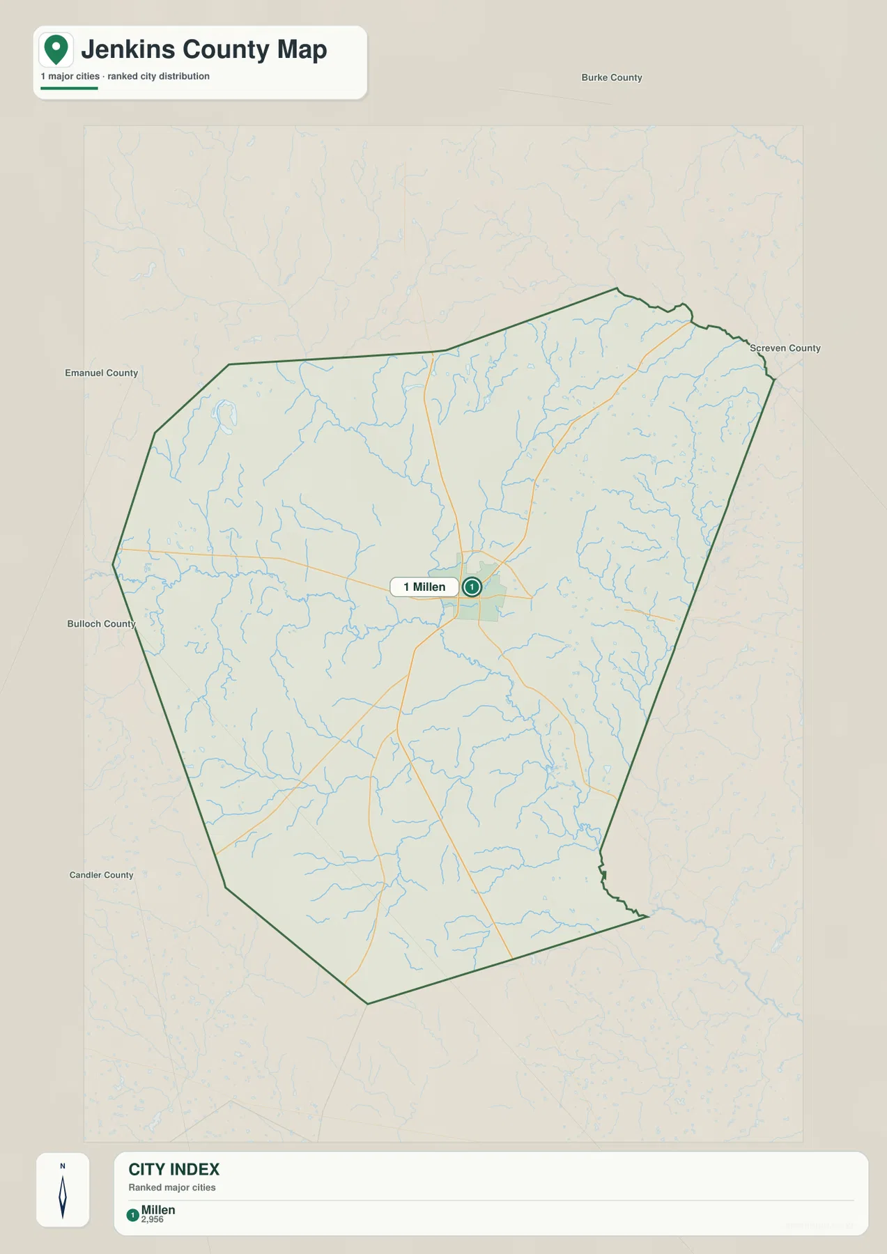
This map should not be read as a complete inventory of every unincorporated community or neighborhood. Its purpose is to make the county’s main urban center easy to find. For a first look, the city map is often the fastest option; once Millen is located, the county reference map adds route numbers, surrounding places, and more geographic detail. The two maps therefore work well as a pair without duplicating the same job.
Ogeechee River, Buckhead Creek, and the Smaller Waterways
Water is one of the strongest geographic features on the Jenkins County maps. The Ogeechee River enters from the western side of the county, bends through the central area, and continues toward the southeast. Millen lies near the meeting area of the Ogeechee River and Buckhead Creek, a relationship also noted in regional planning sources. Once the road labels are removed and the water network is emphasized, the county looks very different: the river and branching creeks become the main structure.
Buckhead Creek descends from the northern part of the county, with Little Buckhead Creek and Spring Mill Branch shown nearby. Horse Creek is labeled on the eastern side, while Cypress Creek appears to the west. Farther south, Richardson Creek and Sculls Creek drain toward the larger river system. The map also identifies smaller named water bodies including Jackson Pond, Jones Pond, Big Dukes Pond, Chew Millpond, and Hendley Pond. These labels make the water map particularly useful for local research because a general county road map may show the same blue lines without making their names as prominent.
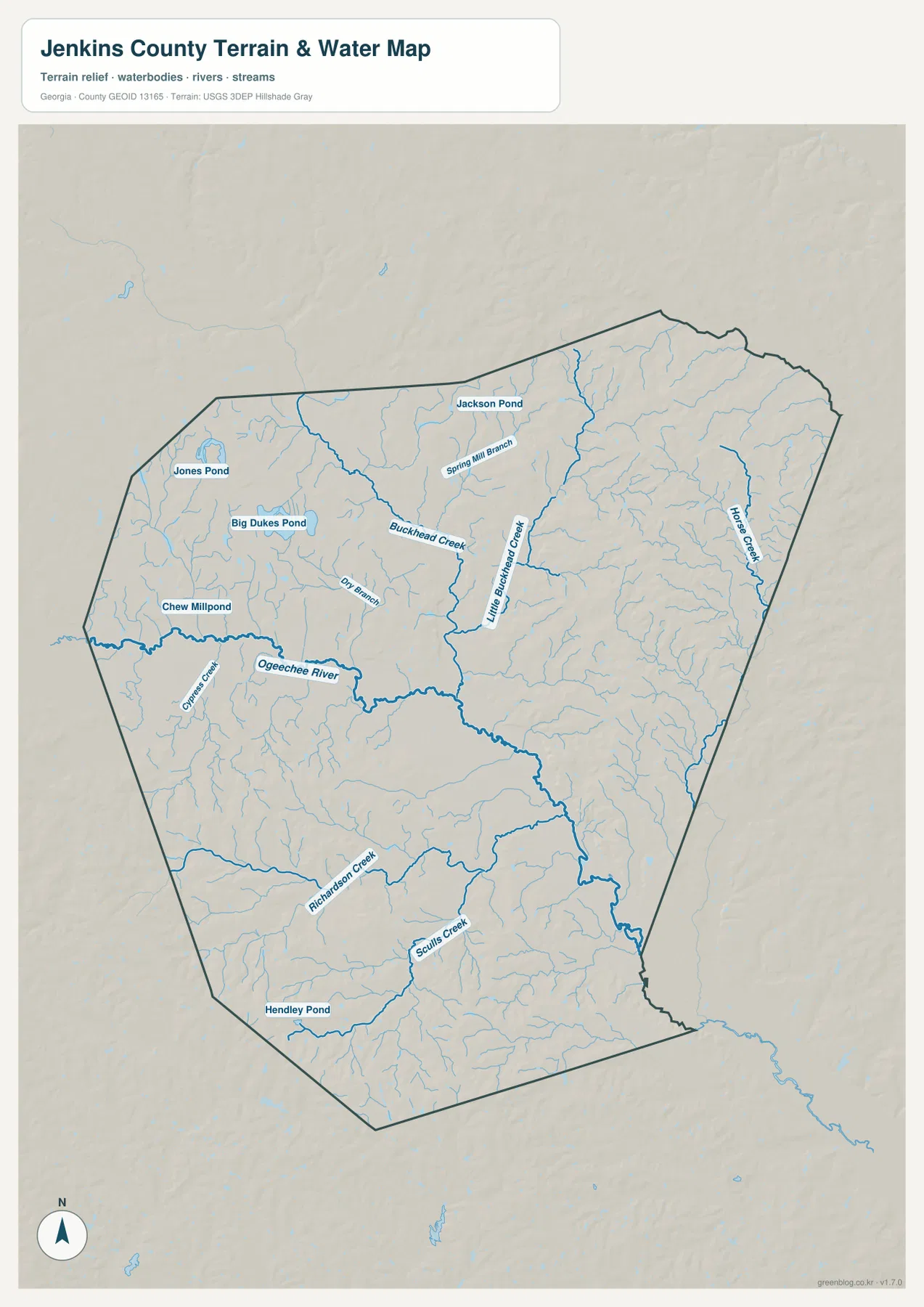
The water map is a reference for drainage features and named waterways, not a flood-risk product. It does not show FEMA flood zones, parcel ownership, legal stream buffers, water depth, or safe boating channels. Someone researching flood exposure should consult official flood-hazard data, while property questions require parcel and deed records. For general geography, however, this map clearly shows where the county’s larger and smaller streams are concentrated and how they connect to the Ogeechee River.
Elevation from the Ogeechee Lowlands to Higher Rolling Ground
The elevation map adds another layer to the water network. The map reports an actual county range of roughly 33 to 110 meters, with a mean elevation of about 65 meters. Green tones mark lower ground, while yellow, orange, and brown areas indicate progressively higher terrain. The broad green corridor through the center and southeast closely follows the main river lowlands, making the connection between drainage and elevation easy to see.
Higher, more textured ground appears most strongly in the northeastern and southwestern parts of the county, with additional rolling terrain around the edges of the main lowland. Jenkins County is not a mountain county, but the shaded-relief surface makes clear that it is not perfectly flat either. Short ridges and gentle rises create local differences in height, while the river and larger creeks occupy the lower corridors between them. Comparing this image with the water map is especially useful because many of the stream lines fit naturally into the lower green areas.
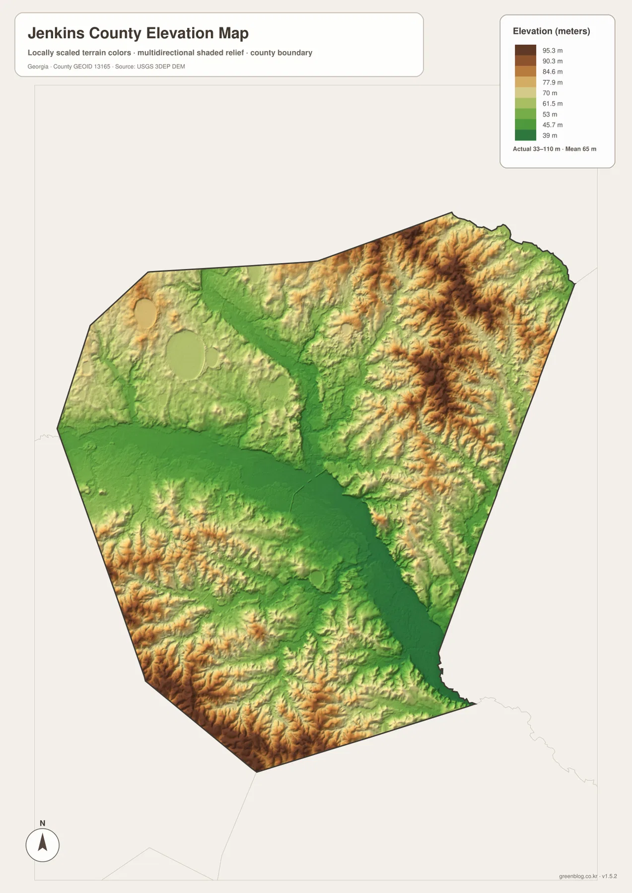
The surface is based on USGS 3D Elevation Program data and has been generalized for county-scale viewing. It is appropriate for understanding broad terrain differences, but it is not survey-grade or engineering-grade elevation. A builder, engineer, landowner, or drainage designer who needs the exact height of a specific site should use detailed elevation data and professional survey information instead of estimating a property elevation from the colors on this map.
Magnolia Springs and the Rural Landscape North of Millen
One of the best-known natural and historical sites in Jenkins County is Magnolia Springs State Park. Georgia State Parks places the park between Millen and Perkins and describes it as a spring-centered landscape with clear water, a small lake, trails, wildlife, and Civil War history connected with Camp Lawton. The park is not the main subject of every map on this page, but it provides valuable context for the northern part of the county and for the water-rich landscape beyond Millen.
The Millen–Jenkins County Scenic Byway offers another way to connect the maps with what visitors see on the ground. Georgia DOT describes a route that includes wooded areas, pasture, historic farmhouses, small communities, and broad farmland along State Route 17. That description fits the county map well: away from Millen, settlement becomes more scattered and the road network crosses a largely rural landscape. The map is therefore useful not only for finding the county seat but also for understanding why local travel often depends on a small number of state and U.S. routes linking widely spaced destinations.
The county’s history also helps explain the importance of Millen in this rural setting. Jenkins County was created in 1905, and Millen became its county seat. The town’s earlier railroad role and its position near the river and major roads made it a natural center for government and commerce. Those historical facts should not be confused with a modern land-use map, but they do help explain the pattern visible today: one clearly dominant city surrounded by smaller communities, farms, forests, creeks, and recreation areas.
Choosing the Right Jenkins County Map for Your Task
Each map is most useful when matched to a specific question. Start with the county reference map when you need the overall boundary, Millen, route numbers, and neighboring counties. Use the city-focused view when the main goal is simply to locate Millen within the county. Switch to the water map for named rivers, creeks, branches, and ponds, and use the elevation map when the question concerns broad differences between river lowlands and higher rolling ground.
- County orientation: Use the reference map to see Jenkins County in relation to Burke, Screven, Emanuel, Bulloch, and Candler counties.
- Millen-centered research: Use the city map to locate the county seat quickly, then add the county map for route numbers and surrounding places.
- Waterway identification: Use the water map for the Ogeechee River, Buckhead Creek, Richardson Creek, Sculls Creek, smaller branches, and named ponds.
- Terrain comparison: Use the elevation map to compare lower river corridors with higher ridges and rolling ground around the county margins.
- Printing and presentations: Use the high-resolution JPG files in the ZIP when the on-page WebP preview is too small for print, slides, or a large classroom display.
Using two maps side by side can answer questions that a single view cannot. Millen is visually dominant on the city map, while the water map shifts attention toward the Ogeechee River and Buckhead Creek. The elevation map removes most place-name detail and instead makes the low river corridor stand out against higher terrain. That change in emphasis is intentional. Rather than treating the four maps as interchangeable versions, it is better to use each one for the type of information it communicates most clearly.
Frequently Asked Questions
Which map is best for finding Millen and the main roads?
Start with the county reference map or the city-focused map. The county map shows Millen together with major numbered routes and surrounding places, while the city map makes Millen the clearest visual landmark. For live navigation, closures, or construction, use a current Georgia DOT or navigation source in addition to these reference maps.
Does the water map show flood-risk areas?
No. It identifies the Ogeechee River, Buckhead Creek, smaller tributaries, and named ponds, but it does not display flood zones or predicted inundation. Flood-risk questions should be answered with official FEMA and local flood-hazard information rather than with this general water-reference map.
Can the elevation map be used for surveying or engineering?
No. The elevation map is intended to show broad county-scale differences, including the roughly 33–110 meter elevation range, lower river corridors, and higher rolling ground. Exact site elevations for construction, drainage, property work, or engineering should come from detailed elevation products and professional survey data.
Map File Information
Jenkins County A3 Map Files
- Included Files: Map files described on this page
- File Type: ZIP archive
- Intended Use: Printing, education, presentations, and map-based projects
Related Maps
Sources and References
- U.S. Census Bureau – Jenkins County QuickFacts
- New Georgia Encyclopedia – Jenkins County
- Georgia Department of Transportation – Jenkins County Highway Map
- Georgia State Parks – Magnolia Springs State Park
- USGS National Hydrography
- USGS 3D Elevation Program
Green Map creates custom-edited map images using open geographic data sources such as geoBoundaries, Natural Earth, OpenStreetMap, and government open data. These maps are edited visual materials, not raw data files, and are provided for education, documents, presentations, and graphic reference.