Columbia County lies just northwest of Augusta, where a fast-growing suburban corridor meets the Savannah River and the long shoreline of J. Strom Thurmond Lake. The maps on this page separate that geography into clear views of roads and county boundaries, incorporated cities, waterways, and elevation. If you need the larger originals, the download box below provides four high-resolution A3 JPG maps in one ZIP for printing, presentations, classroom use, and general regional reference.
The county is not organized around a single modern downtown. Appling remains the historic and legal county seat, Grovetown and Harlem are the two incorporated cities shown on the city map, and the large Evans and Martinez population centers spread across the eastern side. Water adds another strong geographic pattern: J. Strom Thurmond Lake occupies the northeast, the Savannah River follows the eastern side, and Kiokee Creek and its tributaries cut through the interior. The elevation map then shows how those streams sit within a rolling landscape rather than a flat suburban plain.
Table of Contents
From Appling to Grovetown: roads, places, and the county outline
The county map shows a set of distinct settlement areas rather than one continuous city. Appling sits in the north-central part of the county, Grovetown is in the southeast, and Harlem is in the southwest. Evans and Martinez appear along the eastern side, much closer to the Augusta urban area. Major numbered routes include 221 through the Appling–Harlem side, 47 and 223 across the central and southern interior, and 232 through the eastern suburban corridor. Interstate 20, shown as 402 on the map, crosses the southern county near the 78/278 corridor.
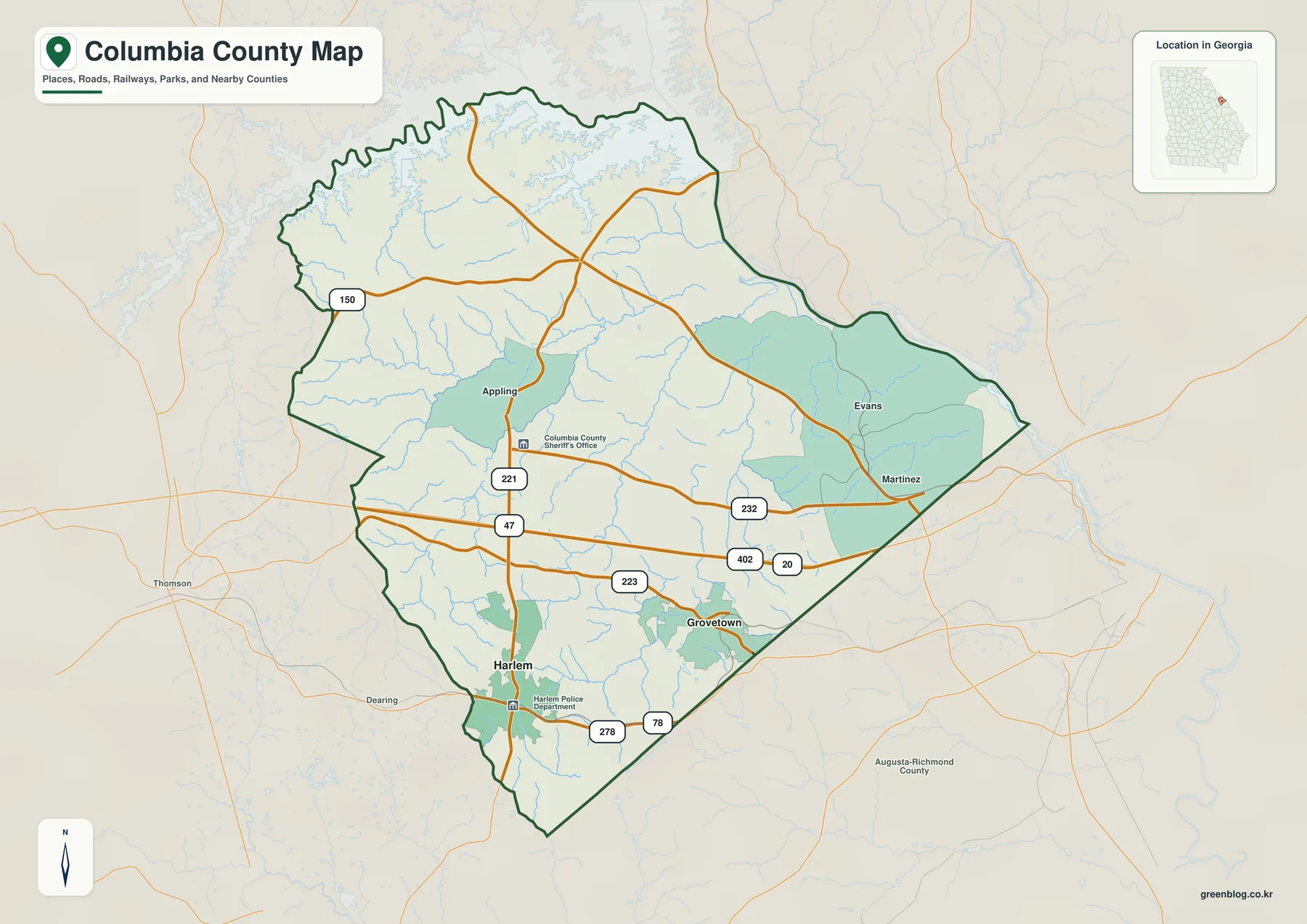
Those labels describe different legal and practical roles. Appling is the county seat but is no longer an incorporated municipality. Grovetown and Harlem are incorporated cities. Evans and Martinez, by contrast, are census-designated places, yet both are major population centers. The 2020 census counted 34,536 people in Evans and 34,535 in Martinez, so a map that showed only incorporated cities would badly understate the size of the eastern settlement corridor.
The location of government services adds another distinction. Columbia County records place the modern government center and Justice Center in Evans, while Appling retains its historic courthouse role and county-seat status. Most court hearings are held in Evans, with some sessions still conducted in Appling. That split is useful when reading the map because a county-seat symbol does not necessarily identify the place with the largest population or the greatest concentration of current public services.
The southern road pattern also helps explain the county’s relationship with Augusta. Interstate 20 provides the strongest east–west regional connection, while the Harlem–Grovetown side follows long-established transportation corridors that predate the modern freeway. This map is useful for countywide orientation, but it is not a traffic map: it does not show lane counts, current congestion, turn restrictions, or travel times. Use current GDOT or navigation data for routing decisions.
Grovetown and Harlem on the incorporated-city map
The city map isolates Columbia County’s two incorporated cities. Grovetown appears as the larger southeastern city and Harlem as the smaller southwestern city. The City Index on the supplied map lists Grovetown at 17,014 and Harlem at 3,885, making the contrast in city size immediately visible. Those figures are the values used for this map layer; for the newest population estimate, check the Census Bureau’s current tables.
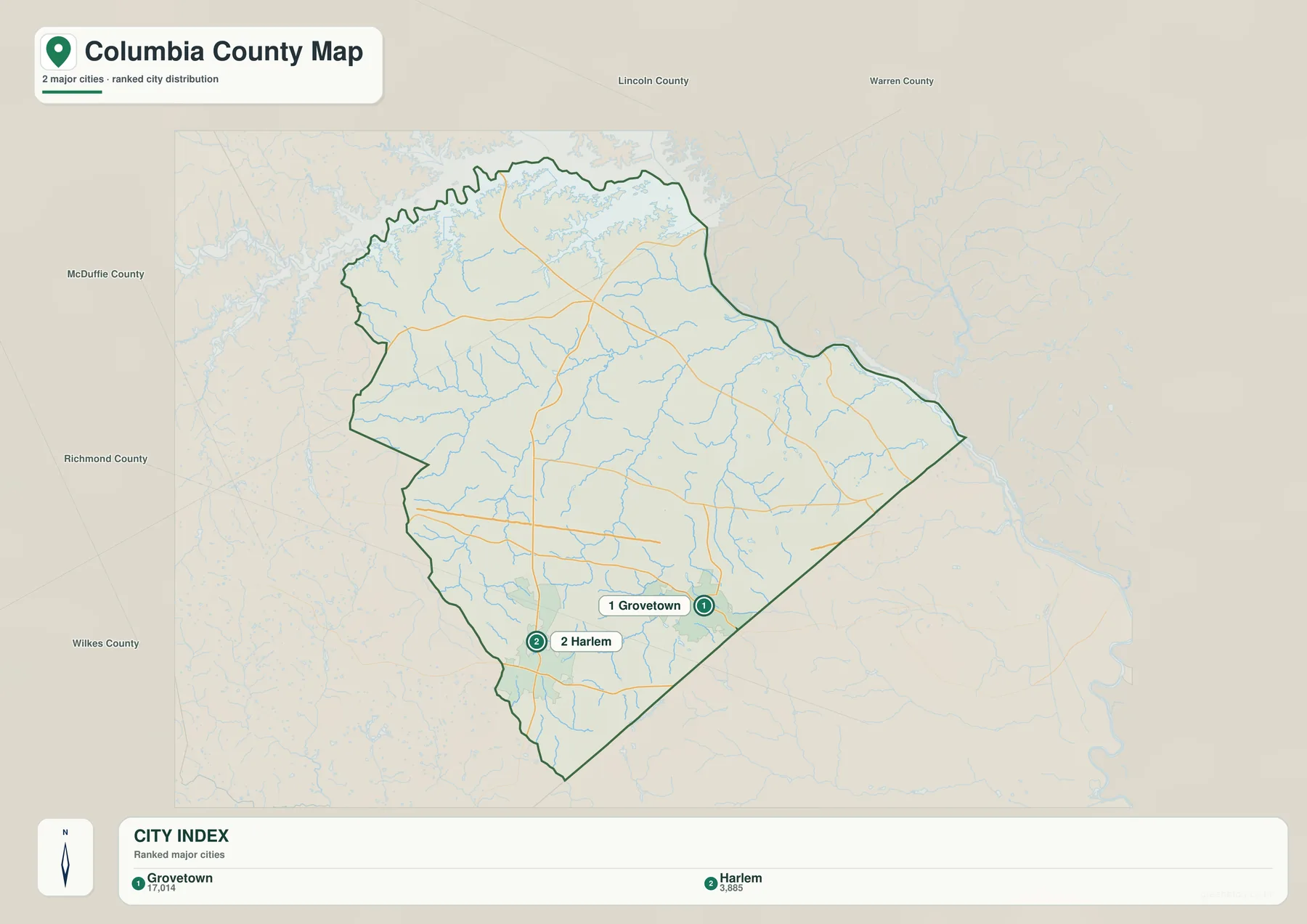
The omissions are just as informative as the labels. Appling is absent because it is no longer incorporated, while Evans and Martinez are CDPs rather than cities. That means the city map should be read as an administrative category map, not a complete settlement map. Pairing it with the county map makes the difference clear: the eastern suburban area is heavily settled even though it is not represented by an incorporated-city marker.
Grovetown also illustrates the pace of change. The existing verified material in the package gives a 2025 estimate of 17,939 people, 15.5 percent above the 2020 estimates base. Columbia County as a whole was estimated at 169,189 residents in 2025, up 8.4 percent from the 2020 base. These numbers help explain why the I-20 corridor and the Evans–Martinez–Grovetown side attract so much attention in county planning for roads, schools, utilities, housing, and stormwater systems.
Harlem represents a different part of the county. It is smaller and farther southwest, but it grew along the historic Georgia Railroad corridor. Grovetown developed along the same broader southern transportation zone. The current road map therefore reflects both modern suburban growth and older rail-era geography rather than a completely new pattern imposed by recent development.
Savannah River, J. Strom Thurmond Lake, and the interior creek network
The water map is dominated by J. Strom Thurmond Lake along the northeast and the Savannah River along the eastern edge. In Georgia, the reservoir is also widely known as Clarks Hill Lake. Existing U.S. Army Corps of Engineers material in the package describes a full-pool area of about 71,100 acres and a reservoir that reaches far upstream along the Savannah and Little River systems. Its long coves and branching shoreline make the northeastern county boundary much more intricate than a straight administrative line.
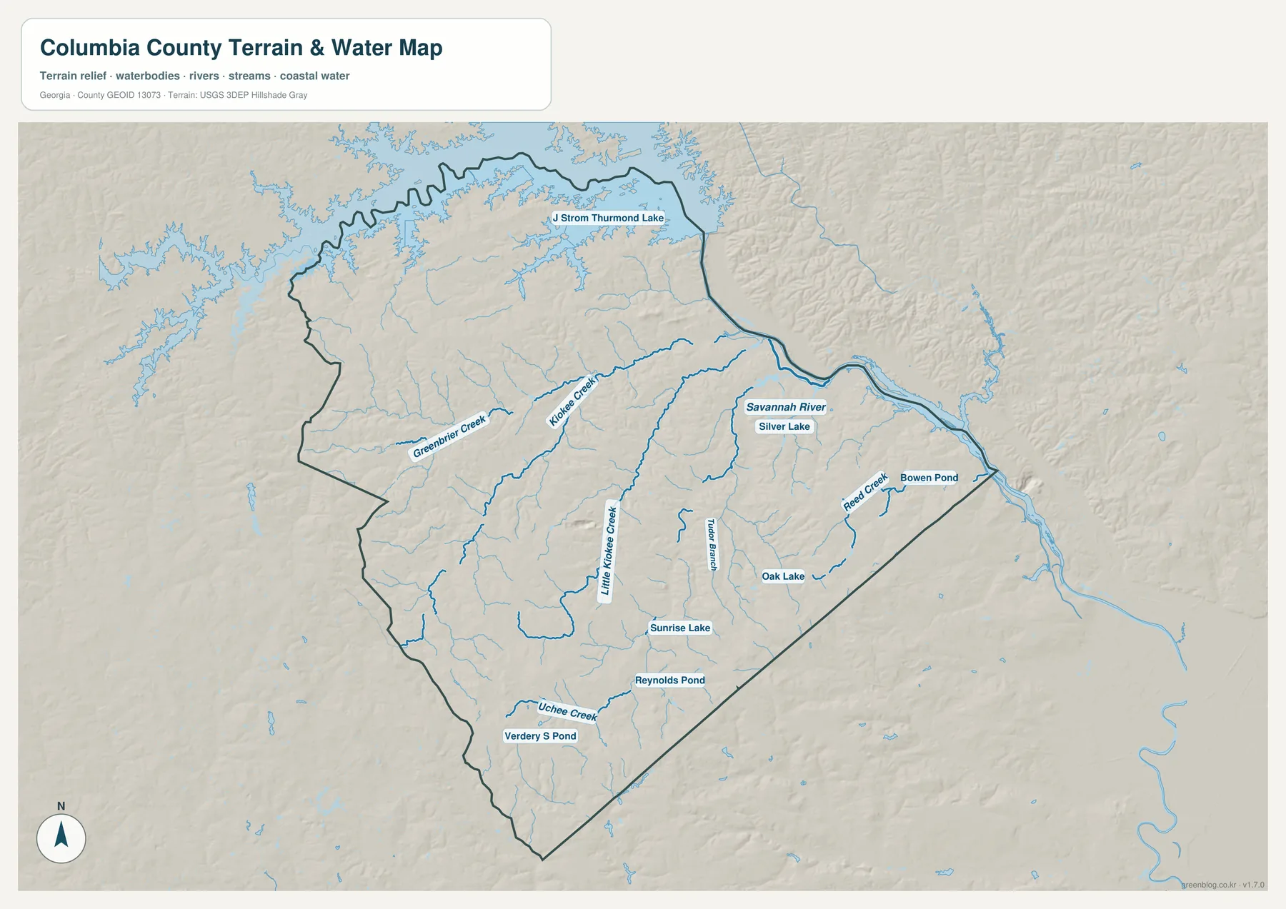
Inside the county, Kiokee Creek and Little Kiokee Creek are prominent. Greenbrier Creek crosses the western side, Uchee Creek appears in the south, and Reed Creek reaches toward the Savannah River on the east. Taylor Branch and many smaller tributaries fill in the gaps. The map also labels Silver Lake, Oak Lake, Sunrise Lake, Reynolds Pond, Verdery S Pond, and Bowen Pond, giving a much better sense of the small-water network than the general county map.
Kiokee Creek is particularly useful for connecting the map to measured water data. USGS maintains monitoring-location record 02195340 near the creek’s mouth close to Appling. Columbia County environmental-management material also treats the Savannah River, the reservoir, and local creeks and streams as important surface-water resources. In a rapidly developing county, those channels matter for runoff, stormwater management, and water quality as well as for ordinary geographic orientation.
This water reference should not be treated as a flood, navigation, property, or shoreline-permit map. It does not provide flood elevations, water depth, boat access, parcel boundaries, or federal shoreline-allocation categories. USACE is the appropriate source for reservoir shoreline use, FEMA for flood hazards, and county GIS for local parcels and regulations.
Rolling uplands, creek valleys, and the elevation surface
The elevation map makes the county’s relief easier to see than a road map does. Higher brown and orange terrain is concentrated across much of the west and northwest, with additional uplands in the southwest and southeast. Green lowlands follow the Savannah River side and many of the creek valleys. The deeply branching low corridors explain why the water map contains so many tributaries and why the Thurmond Lake shoreline cuts so far into the northeastern landscape.
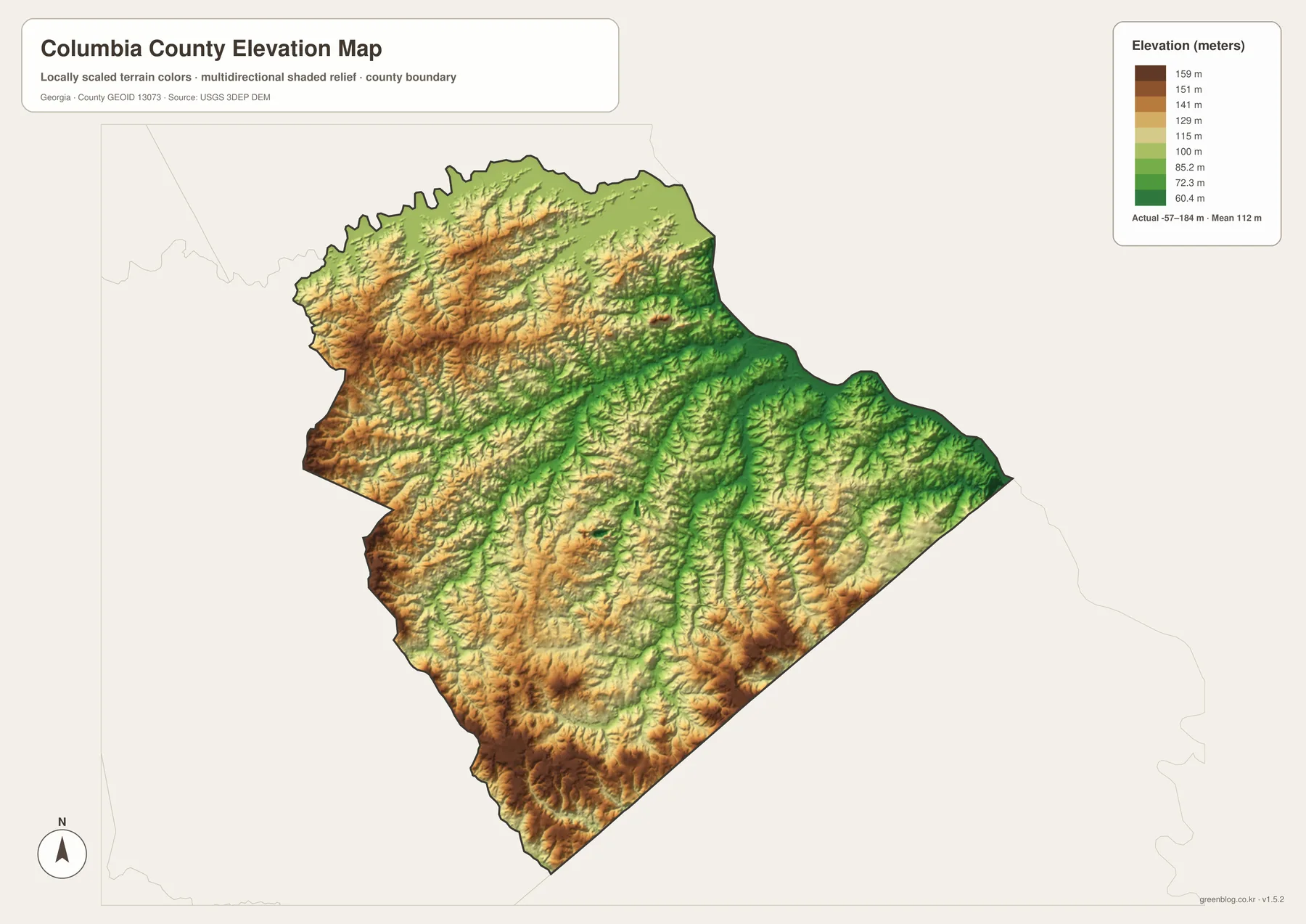
The supplied elevation legend reports an actual range of about -57 to 184 meters and a mean of about 112 meters. Those values belong to the generalized terrain surface used for this countywide reference. They are best used to compare relative highs and lows across the map, not as survey measurements for an individual lot. If an engineering, drainage, construction, or precise property elevation is needed, use the underlying USGS 3D Elevation Program data or a professional survey.
Comparing the water and elevation layers shows a consistent relationship: lower green corridors commonly align with streams, while higher ridges separate neighboring drainage paths. Kiokee Creek and Little Kiokee Creek occupy lower channels leading toward the reservoir and Savannah system. That does not mean the map can predict flooding or road grade, but it does make the county’s pattern of ridges, valleys, and branching streams much easier to recognize.
The terrain also adds useful context to the suburban pattern. Evans, Martinez, and Grovetown belong to the Augusta growth area, yet the land between neighborhoods is still crossed by small valleys and creek corridors. Around the lake, the same terrain creates irregular coves, narrow peninsulas, and more broken road access than the flatter-looking city map suggests.
Choosing the right map for a Columbia County question
For a first look, start with the county map to locate Appling, Evans, Martinez, Grovetown, Harlem, and the major numbered roads. Use the city map when the distinction between incorporated cities and other population centers matters. Move to the water map for the reservoir, Savannah River, Kiokee Creek, and smaller tributaries, then compare the elevation layer when you want to see whether a creek sits in a lower valley or whether a route crosses higher rolling ground.
One useful example is the Appling-to-eastern-suburbs side. The county map shows the place relationship and roads; the water map reveals the Kiokee Creek system draining toward the Savannah basin; the elevation map shows the lower creek corridors cutting between higher ridges. On the southern side, Grovetown and Harlem are easier to understand in relation to I-20 and the long-established rail and highway corridor. Looking across layers turns a simple “where is this town?” question into a clearer picture of how roads, settlement, water, and terrain fit together.
- Orientation: Use the county map for places, surrounding counties, and major routes.
- Administrative city comparison: Use the city map for Grovetown and Harlem, remembering that Evans and Martinez are CDPs.
- Water geography: Trace J. Strom Thurmond Lake, the Savannah River, Kiokee Creek, and the smaller creeks and ponds.
- Terrain comparison: Use the elevation map to distinguish western uplands from lower river and creek valleys.
- Large-format use: Download the ZIP when you need the four high-resolution A3 JPG originals.
These files are designed for general reference, teaching, presentations, local orientation, and printed handouts. They are not substitutes for parcel surveys, school-zone maps, election districts, flood studies, shoreline permits, or current turn-by-turn navigation. For those tasks, use the responsible county, state, or federal data source.
Frequently Asked Questions
Why is Appling the county seat if Evans is a larger activity center?
Appling is the historic and legal county seat, but much of the county’s modern government and court activity is based in Evans. The two places therefore serve different roles: one preserves the official and historic seat, while the other contains major present-day public-service facilities.
Why does the city map show Grovetown and Harlem but not Evans or Martinez?
The city map is based on incorporated cities. Grovetown and Harlem are incorporated, while Evans and Martinez are census-designated places. Appling is the county seat but is not currently an incorporated municipality. The county map should be used when you want the broader settlement picture.
Are Clarks Hill Lake and J. Strom Thurmond Lake the same place?
Yes. They are two names used for the same large reservoir on the Savannah River system. Federal sources generally use J. Strom Thurmond Lake, while Clarks Hill Lake remains a common name in Georgia.
What is included in the map download ZIP?
The ZIP contains four original high-resolution A3 JPG files: a county road-and-place map, an incorporated-city map, a water map, and an elevation map. The WebP images in the article are smaller previews intended for on-page viewing.
Map File Information
Columbia County Map Files
- Included Files: 4 high-resolution A3 JPG maps described on this page
- File Type: JPG files in a ZIP archive
- Intended Use: Printing, education, presentations, and map-based projects
Related Maps
Sources and References
Population, administrative, and historical details follow the verified material preserved in the package. Water and elevation descriptions use the supplied maps together with official source links. For current statistics or legal boundaries, check the latest version published by the responsible agency.
- U.S. Census Bureau QuickFacts: Columbia County, Georgia
- New Georgia Encyclopedia: Columbia County profile and history
- Columbia County: Foundations for the Future comprehensive plan
- USGS: Kiokee Creek at Mouth monitoring location
- U.S. Army Corps of Engineers: J. Strom Thurmond Dam and Lake
- USGS 3D Elevation Program
Green Map creates custom-edited map images using open geographic data sources such as geoBoundaries, Natural Earth, OpenStreetMap, and government open data. These maps are edited visual materials, not raw data files, and are provided for education, documents, presentations, and graphic reference.