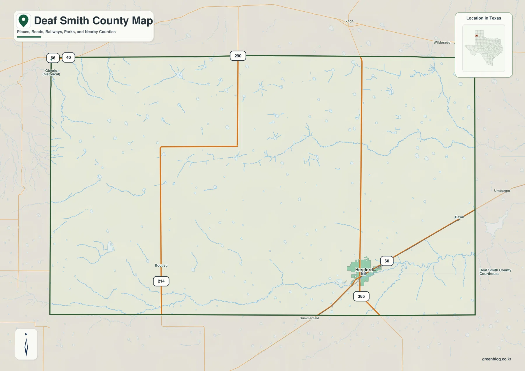
Deaf Smith County sits on the far western side of the Texas Panhandle, where the county line meets New Mexico and the high plains stretch for long distances between settlements. Hereford, the county seat, is concentrated near the southeast corner rather than the geographic center. The maps on this page show that unusual arrangement clearly: US 60 and US 385 meet at Hereford, Interstate 40 clips the far northwest near Glenrio, Palo Duro and Tierra Blanca creeks cross different parts of the county, and the land generally steps down from west to east. A downloadable ZIP with high-resolution A3 JPG versions of the county, city, water, and elevation maps is also provided below.
Table of Contents
Hereford is the county’s southeast anchor
The general county map makes Hereford easy to locate because several important lines come together there. US 60 approaches from the southwest and continues northeast, while US 385 runs north-south through the city. Hereford is close to both the southern and eastern sides of the county, yet it carries the strongest concentration of roads and mapped development. That position is more useful than simply memorizing the county seat: it explains why the busiest-looking part of the map is not in the middle of the county.
Other routes serve very different parts of the county. State Highway 214 runs through the western interior near Bootleg, and Interstate 40 crosses only the extreme northwest corner around the historic Glenrio area at the New Mexico line. These routes do not form one symmetrical network around Hereford. Instead, the map shows a major southeast hub, a western north-south route, and a separate long-distance corridor at the northwest edge. That separation is one of the clearest geographic features of Deaf Smith County.
The city index emphasizes one major center
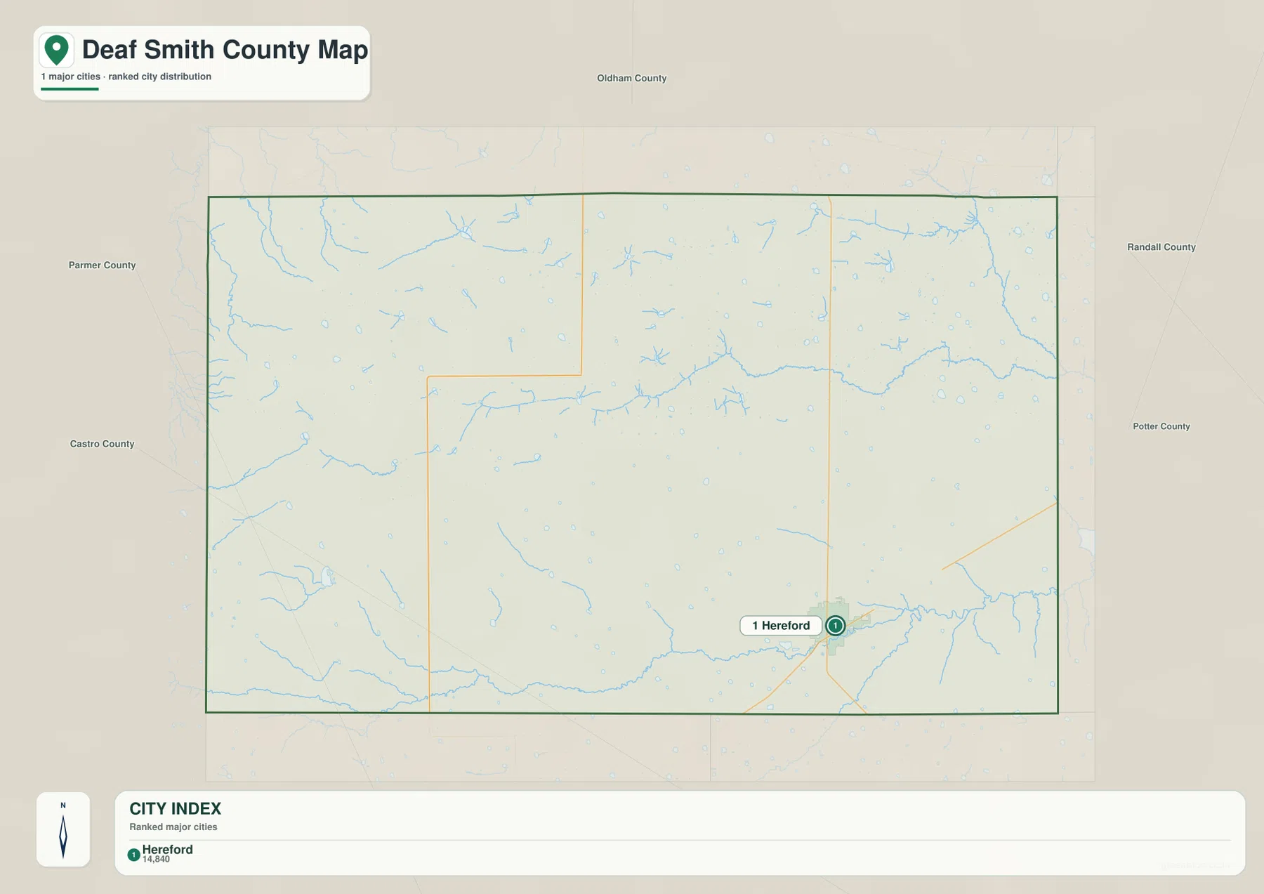
The city map ranks Hereford as the only major city in the county. That simple result fits the wider map: much of Deaf Smith County is open agricultural and ranch country, with long distances between the largest concentration of streets and the outer county lines. Hereford appears near the southeast corner, so the city map is especially useful for showing how much of the county lies west and north of its main population center.
The general map adds smaller names such as Dawn, Summerfield, Bootleg, and Glenrio, but they are not displayed as equivalent urban centers. Comparing the two maps prevents a common misunderstanding that every labeled place has the same role. For a quick explanation of settlement, use the city map to establish Hereford first, then switch to the county map when you need the smaller communities and the roads that connect them.
Palo Duro and Tierra Blanca tell different drainage stories
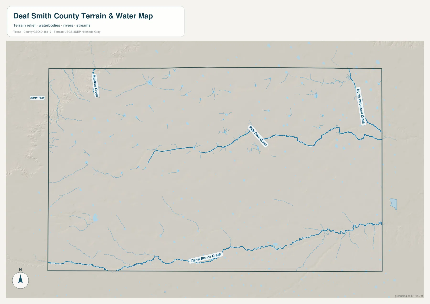
The water map is dominated by three named creek systems rather than a single large river. Tierra Blanca Creek follows the southern part of the county and runs close to the area south of Hereford. Palo Duro Creek crosses the central and eastern portion of the map, while North Palo Duro Creek appears along the northeast side. The creeks are separated enough that each provides a different reference line for reading the county.
Their shapes also become more meaningful when compared with the terrain. Palo Duro Creek bends eastward through a broad shallow drainage before continuing toward Randall County, and Tierra Blanca Creek follows the lower southern side of the county. The water map contains many smaller blue channels and depressions as well, but the named creeks provide the clearest orientation. They show that the High Plains surface is not featureless even where the surrounding roads and field patterns may look very regular.
Elevation drops broadly from west to east
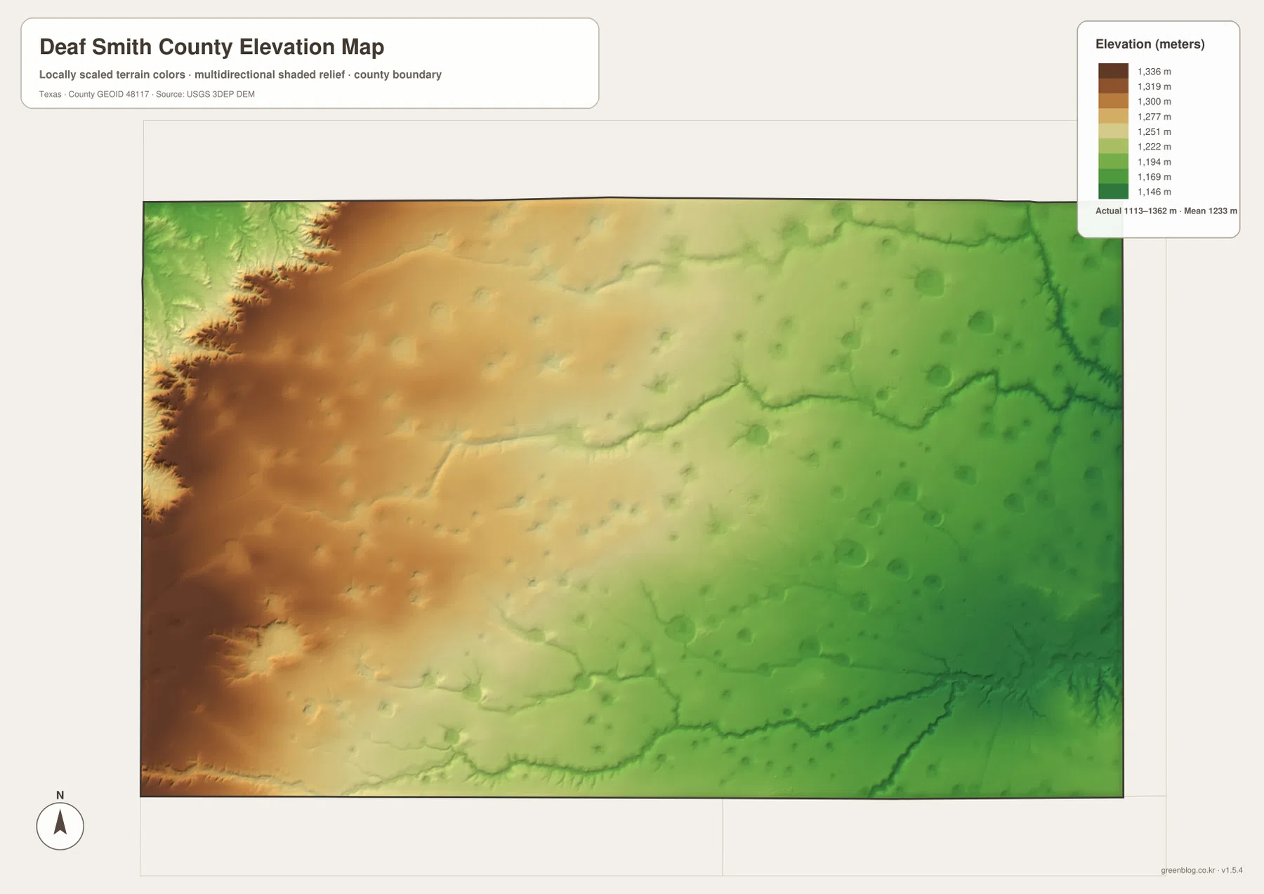
The elevation map adds a pattern that is easy to miss on a road map. Brown and tan colors cover much of the west and northwest, while greens spread across the east. The legend notes an actual elevation range of roughly 1,113 to 1,362 meters for the mapped county surface, with a mean near 1,233 meters. The important point is not the individual number at every location but the broad west-to-east descent across the county.
This is a high-plains landscape rather than a mountain county, so the change usually appears as a wide regional slope instead of isolated peaks. Still, drainage cuts are clearly visible, especially where creeks have carved into the surface. When the elevation and water maps are viewed together, the eastward course of the Palo Duro system and the lower ground around Tierra Blanca Creek make more sense. The combination explains the terrain with less guesswork than either map can provide by itself.
A Texas county with a New Mexico edge
Deaf Smith County is unusual among many Panhandle counties because its entire western side is a state boundary. New Mexico lies directly to the west, Oldham County is to the north, Randall County is to the east, and Parmer and Castro counties form the southern side. This arrangement matters when reading transportation. A route leaving the county to the west does not simply enter another Texas county; it crosses a state line and, near Glenrio, reaches a corridor with a long history of interstate travel.
The northwest and southeast corners therefore function very differently. Interstate 40 and the historic US 66 corridor touch the Glenrio area near New Mexico, while Hereford sits far away in the southeast where US 60 and US 385 serve the county’s main urban center. Looking at those two corners together gives a better sense of the county’s large east-west extent than a boundary outline alone. It also explains why a traveler on I-40 can technically pass through Deaf Smith County without going anywhere near Hereford.
From La Plata to Hereford: the county seat followed transportation
Hereford’s present importance has a geographic history. The Handbook of Texas records that Deaf Smith County was organized in 1890 with La Plata as its first county seat. Railroad construction across the southeastern part of the county then created a strong new transportation advantage. Hereford grew along that line and replaced La Plata as the county seat after an 1898 election. The modern map still reflects the result: Hereford remains the strongest road and settlement focus even though it is well away from the county center.
The county’s western half was also part of the historic XIT Ranch, a reminder that the broad open spaces visible on today’s map were shaped by large-scale ranching before intensive farming expanded. Later agriculture, rail access, and highway development changed how people used the land, but the settlement pattern remained relatively concentrated. This background helps explain why the map contains one major urban center surrounded by a very large rural area instead of a chain of similarly sized towns.
Choose the map that matches the question
Use the county map when you need roads, smaller place names, and the relationship between Hereford and the outer county lines. The city map is cleaner when the goal is simply to show where the county’s main urban center sits. For natural geography, the water map is the fastest way to trace Tierra Blanca, Palo Duro, and North Palo Duro creeks, while the elevation map shows why the western and eastern sides do not have the same terrain.
For a classroom, report, or printed handout, pairing two maps is often more effective than using every layer at once. The county and city maps work well for transportation and settlement; the water and elevation maps make a stronger pair for terrain and drainage. The downloadable files retain the larger A3 JPG format, so you can use the preview maps for quick reading and the ZIP when a larger print or clearer presentation image is needed.
Frequently Asked Questions
Where should I start when reading a Deaf Smith County map?
Start with Hereford in the southeast. US 60 and US 385 meet there, so it provides a quick reference for the main city and the two most obvious road directions before you move outward to Glenrio, SH 214, and the county boundaries.
Which creeks are easiest to identify on the water map?
Tierra Blanca Creek is the main named feature across the south, Palo Duro Creek crosses the central-to-eastern area, and North Palo Duro Creek appears in the northeast. Using those three names as anchors makes the smaller drainage lines easier to place.
Does Interstate 40 pass through Hereford?
No. Interstate 40 only clips the far northwest corner of Deaf Smith County near Glenrio. Hereford is in the southeast and is served by US 60 and US 385, so the interstate corridor and the county’s main city are widely separated.
Map File Information
The ZIP below contains the Deaf Smith County maps shown on this page as high-resolution A3 JPG files. Use the larger originals when you need a print-ready image, a classroom handout, or a clearer map for comparing roads, settlements, drainage, and elevation.
- Included Files: county map, city map, water map, elevation map
- File Type: ZIP containing 4 JPG files
Related Maps
- Oldham County Texas map
- Parmer County Texas map
- Potter County Texas map
- Randall County Texas map
- Swisher County Texas map
Sources and References
- Handbook of Texas – Deaf Smith County: county boundaries, Hereford’s county-seat role, major creek systems, transportation history, and regional background.
- Handbook of Texas – Hereford: the railroad-era growth of Hereford and its development as the county seat.
- U.S. Census Bureau TIGER/Line Shapefiles: official county and administrative boundary data.
- USGS National Hydrography: official hydrography and drainage data.
- USGS 3D Elevation Program: official elevation and terrain data.
Green Map creates custom-edited map images using open geographic data sources such as geoBoundaries, Natural Earth, OpenStreetMap, and government open data.
These maps are edited visual materials, not raw data files, and are provided for education, documents, presentations, and graphic reference.