You can download high-resolution Forsyth County map files on this page as A3 JPGs bundled in one ZIP. The same set appears below as WebP previews: a county reference map with roads and place names, a city map comparing six major communities, and a water/terrain map showing the Yadkin River, Muddy Creek, Salem Creek, Salem Lake, Winston Lake, and smaller waterways. Winston-Salem dominates the center of most regional views, but the surrounding communities, road corridors, and water network are essential for understanding the county as a whole.
The strongest geographic contrast is between the large Winston-Salem urban area in the middle of the county and the natural boundary formed by the Yadkin River along the west. Kernersville sits near the eastern edge, Clemmons and Lewisville occupy the southwest and west, and Walkertown and Rural Hall extend the settlement pattern to the northeast and north. On the general map, numbered routes such as 421, 67, 65, 8, 66, 158, 150, 109, and 311 provide a second way to organize those places, while the water map replaces the road framework with rivers, creeks, lakes, and shaded relief.
Table of Contents
Winston-Salem fills the center, but the county continues in several directions
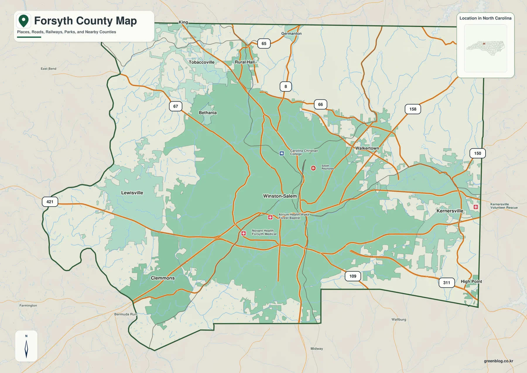
Winston-Salem is the clearest anchor on the county reference map. Its built-up area occupies a broad central portion of Forsyth County, and several major roads cross the city or spread outward from it. Bethania and Rural Hall appear to the north, Tobaccoville lies farther northwest, Lewisville sits to the west, and Clemmons is near the southwest edge. Walkertown and Kernersville form a separate eastern cluster, so the map does not read like a single compact city surrounded by empty land.
The reference map also marks a few institutional locations in the Winston-Salem area, including health and college symbols. Those points make the urban core visually distinct, but the map is not intended to replace a street-level navigation service. Its value is the countywide view: a reader can start in Winston-Salem, move outward to neighboring towns, and still keep the county boundary, major routes, and nearby places visible at the same time.
Route 421 is a practical first line for organizing the road map
Instead of trying to follow every orange road on the county map, Route 421 gives a useful starting line. It enters from the west near Lewisville, crosses the southern side of the Winston-Salem urban area, and continues toward the eastern side of the county. Route 67 is prominent in the northwest, while 65 and 8 help orient the Rural Hall area. Near Walkertown, the 66 and 158 shields stand out and make the northeast easier to distinguish from the central city.
Farther east, Route 150 appears near Kernersville, and the 109 and 311 shields are visible toward the southeast. High Point is labeled beyond the county edge, giving readers a useful regional reference without implying that it is inside Forsyth County. The road map therefore works best as a network of a few memorable corridors rather than as a complete street atlas. Once those corridors are recognized, the relative positions of Kernersville, Clemmons, Lewisville, Walkertown, and Rural Hall become much easier to retain.
The city index separates Winston-Salem from five smaller population centers
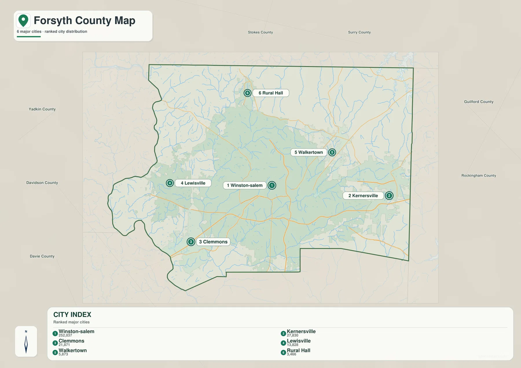
The city map removes most of the detail from the road map and highlights six ranked communities. Winston-Salem is listed first, followed by Kernersville, Clemmons, Lewisville, Walkertown, and Rural Hall. The index also includes numeric values beside the names, but those figures belong to the supplied map package and should be treated as the map’s ranking data rather than assumed to be a current official population table.
The simplified layout makes the county’s settlement pattern easy to see. Winston-Salem sits near the center, Kernersville is close to the eastern boundary, Clemmons is tucked against the southwest, and Lewisville is west of the main city. Walkertown is northeast of Winston-Salem, while Rural Hall is farther north. Comparing this map with the general reference map shows the difference between a city-ranking view and a broader county view that also includes names such as Bethania and Tobaccoville.
The Yadkin River gives the western side a natural boundary reference
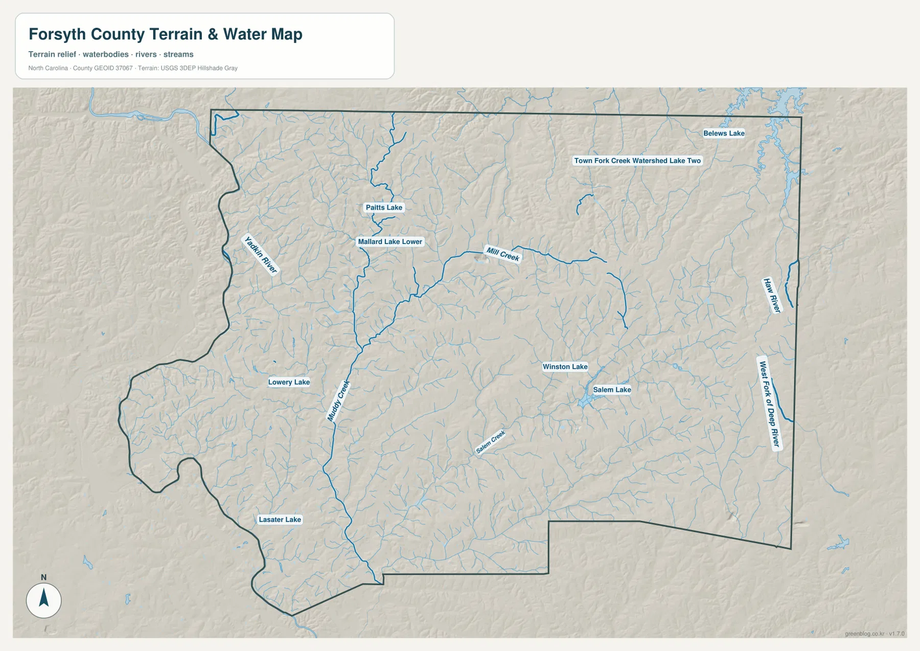
The most prominent water feature on the supplied terrain and water map is the Yadkin River along the western edge of Forsyth County. It provides a very different kind of orientation from the straight or angular county boundary. When the water map is compared with the road map, the river helps explain the western side around Lewisville and Clemmons without relying only on road numbers or municipal labels.
The western half also contains a denser pattern of smaller streams and water bodies than a city-only map suggests. Muddy Creek is one of the strongest interior channels, and several named lakes appear between the Yadkin edge and the Winston-Salem urban area. Lowery Lake, Paitts Lake, and Mallard Lake Lower provide smaller local reference points. These features are useful when a reader needs to distinguish the western watershed landscape from the more heavily labeled central city.
Muddy Creek, Salem Creek, and Salem Lake create an interior water framework
Forsyth County is not defined by the Yadkin River alone. Muddy Creek runs through the western-central part of the map and connects with a web of smaller branches. Mill Creek is labeled farther north, while Salem Creek crosses the southern part of the Winston-Salem area and is closely associated with Salem Lake. The water map makes these streams visible without the dense road network competing for attention.
Several named lakes add finer local detail. Winston Lake and Salem Lake sit near the central urban area, while Paitts Lake and Mallard Lake Lower are farther northwest. Lowery Lake and Lasater Lake are shown toward the southwest, and Town Fork Creek Watershed Lake Two appears in the northern part of the map. Belews Lake is visible beyond the county context near the northeast. Taken together, these labels give readers more than one water landmark for locating neighborhoods and outlying areas.
Relief shading adds terrain context without claiming exact elevations
The water map includes subdued hillshade behind the blue drainage network. The existing material identifies Forsyth as part of northwestern North Carolina’s Piedmont, and the shaded preview shows rolling ground rather than a flat coastal-plain appearance. The relief is especially useful around creek valleys because the surface texture helps readers see that the watercourses occupy lower-looking corridors through gently changing terrain.
There is no separate elevation map in this package. No color-banded elevation layer, contour values, or numeric heights are supplied, so this article does not assign an elevation to Winston-Salem, Clemmons, Kernersville, or any other place from the hillshade alone. Readers who need exact heights or survey-grade elevation differences should use a dedicated official elevation source; the terrain shading here is visual context for the water system.
Nearby place labels help explain what lies just beyond the county outline
The general map intentionally includes some places outside Forsyth County. King and Germanton appear north of the boundary, High Point is shown to the southeast, and Farmington and Bermuda Run provide reference points near the southwest. These names should not be read as additional Forsyth municipalities; they are useful because they show how the county sits within the larger Piedmont road network.
The supplied source text lists Davidson, Davie, Guilford, Stokes, and Yadkin as neighboring counties. That context matters most near the edges, where Kernersville, Clemmons, and Lewisville are closer to adjoining areas than the central Winston-Salem label might suggest. Looking at the outside reference names alongside the county boundary makes it easier to understand why eastern and southwestern travel often connects quickly into neighboring county systems.
Two historical notes help explain the modern county and its central city
The existing article material states that Forsyth County was formed from Stokes County in 1849. It also notes that Winston and Salem merged in 1913 to create the modern Winston-Salem name. Those facts are background rather than information measured from the map, but they help explain why a county dominated by one large city still contains several distinct community names around the urban core.
The county map shows that distinction clearly. Bethania, Rural Hall, Lewisville, Clemmons, Walkertown, and other names remain visible even though Winston-Salem occupies a much larger area. This page keeps the history brief because its primary purpose is geographic orientation and downloadable map files. Readers who need a fuller county history can use the NCpedia reference in the sources section below.
Use the map that matches the information you actually need
The county reference map is the best first choice for general orientation because it combines the county boundary, city names, numbered roads, and selected landmarks. It is useful when you need to compare Winston-Salem with Kernersville, Clemmons, Lewisville, Walkertown, and Rural Hall or when Route 421 and the other major numbered corridors are part of the question. The city map is cleaner when the main task is simply to compare the six ranked communities without the full road network.
The water/terrain map is the better option for the Yadkin River, Muddy Creek, Salem Creek, Salem Lake, Winston Lake, and the smaller drainage network. Because the map includes hillshade, it also gives more environmental context than the city ranking view, although it should not be treated as an elevation chart. Switching between the three maps is usually clearer than trying to force road, settlement, and water information into one crowded image.
For printing, classroom material, presentation slides, or other work that needs larger images than the WebP previews, use the ZIP below. It contains the high-resolution A3 JPG versions corresponding to the county map, city map, and water/terrain map on this page. These are reference maps, so current navigation, legal boundaries, parcel ownership, flood regulation, and exact elevation work should still be checked against the appropriate authoritative source.
Frequently Asked Questions
Why is the Yadkin River useful when reading the western side of Forsyth County?
The Yadkin River follows the western side of the county and provides a natural reference that is different from the road network. It helps readers place Lewisville and Clemmons relative to the county edge and makes the western landscape easier to understand when the water map is compared with the general reference map.
Which six communities are ranked on the supplied Forsyth County city map?
The City Index ranks Winston-Salem, Kernersville, Clemmons, Lewisville, Walkertown, and Rural Hall. The general county map includes additional place names such as Bethania and Tobaccoville, so the city map should be understood as a simplified ranking view rather than a complete list of every labeled community.
What is included in the downloadable Forsyth County ZIP?
The archive contains three high-resolution A3 JPG files matching the county reference map, city map, and water/terrain map. A separate elevation map is not included; terrain relief appears only as background shading on the water/terrain map.
Map File Information
The ZIP contains high-resolution A3 JPG versions of the Forsyth County reference map, city map, and water/terrain map shown on this page.
- Included Files: Use only the versions confirmed in the article and supplied images
- File Type: Use the confirmed download contents
- Intended Use: Printing, education, presentations, and map-based projects
Related Maps
Sources and References
Green Map creates custom-edited map images using open geographic data sources such as geoBoundaries, Natural Earth, OpenStreetMap, and government open data.
These maps are edited visual materials, not raw data files, and are provided for education, documents, presentations, and graphic reference.