Muscogee County sits on Georgia’s western edge, where Columbus and the Chattahoochee River provide the clearest landmarks for understanding the county. This page brings together four views of the same area: a county reference map, a major-city map, a water map, and an elevation map. You can also download all four maps as high-resolution A3 JPG files in one ZIP archive.
The maps are most useful when read together rather than as interchangeable versions of one image. The county map gives the broad road and place context around Columbus, the city map strips the picture down to the county’s dominant urban center, the water map names creeks and lakes that are easy to miss on a general reference map, and the elevation map shows why the western river side looks different from the hillier north and east.
Table of Contents
Columbus anchors the county reference map
The supplied material identifies Columbus as the county seat and consolidated city, and the county reference map reflects that central role. Columbus occupies the main labeled urban area, while the county outline extends eastward and southward around it. Along the western side, the county meets the Alabama direction at the Chattahoochee River, giving the map a strong natural reference line that is useful even before individual roads or facilities are examined.
Several local reference points appear around Columbus. The map labels Columbus State University, Columbus Technical College, the Muscogee County Courthouse, the Columbus airport area, and fire-department locations. Fortson is shown near the northern edge, Upatoi appears toward the east, Box Springs is labeled outside the eastern side, and Battle Park is marked near the southwest. These labels help orient the reader without turning the image into a detailed street or parcel map.
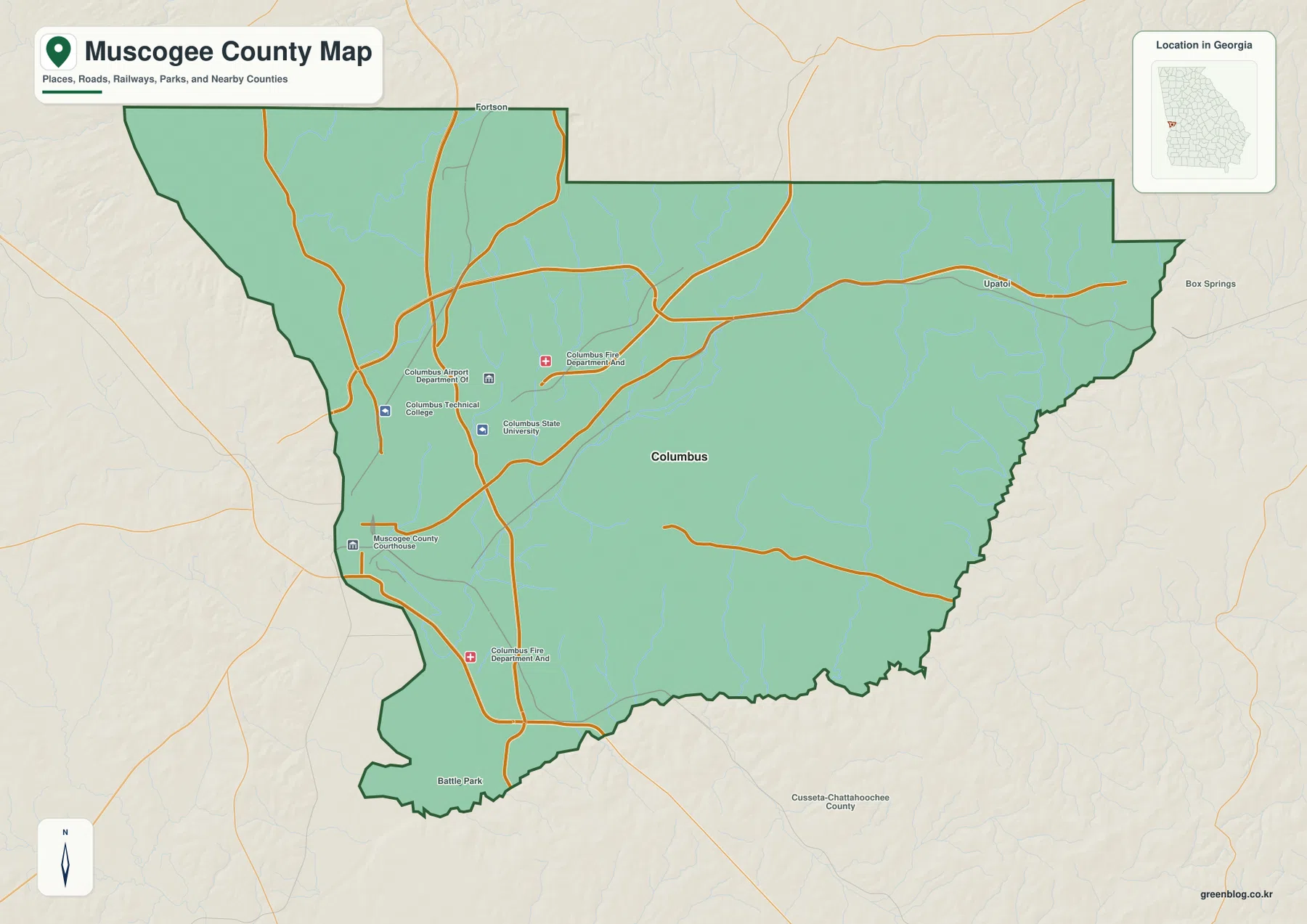
The road network is densest on the western and central side around Columbus and then spreads toward the broader eastern portion of the county. For a reader who only needs to understand how the city relates to the county as a whole, this view is more useful than a street-level map. It also works well as a first map for classroom geography, local-history orientation, or a report that needs a simple county locator with recognizable landmarks.
The major-city view is unusually simple: Columbus stands alone
The city-distribution map makes one feature especially clear. In the supplied map, Columbus is the only place ranked as a major city inside Muscogee County. That does not mean the county contains no neighborhoods, small communities, or other named places. Instead, the map is designed to show the major-city hierarchy, and here that hierarchy is concentrated in Columbus.
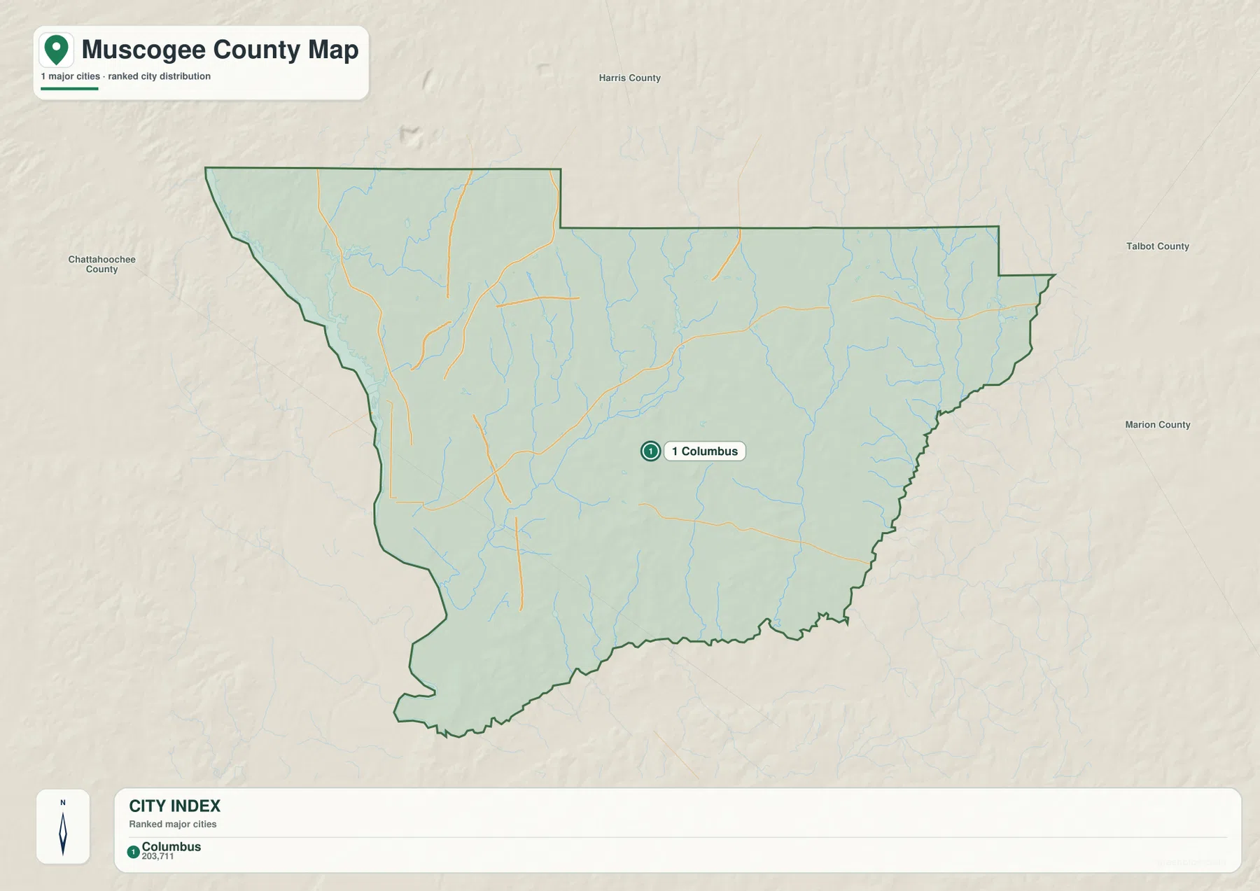
The surrounding county labels make the simplified city map useful for orientation. Harris County is shown to the north, Talbot County and Marion County appear on the eastern side, and Chattahoochee County is labeled to the west in the surrounding reference area. With most facility labels removed, the reader can focus on the position of Columbus within the county outline and see how much of the county’s urban identity is tied to one city.
This is therefore a good map for a quick geographic overview, but it should not be treated as a complete settlement inventory. A smaller community that does not appear on this major-city layer may still be important locally. The map is answering a narrower question: where is the county’s principal urban center?
From the Chattahoochee edge to interior creeks and lakes
Water is one of the strongest geographic themes in the supplied Muscogee County material. The Chattahoochee River defines the broad western context, while the dedicated water map adds a much finer network of named creeks and small lakes across the county. This makes the water layer particularly helpful for readers who want to move beyond the simple county boundary and see how drainage lines and local water bodies are distributed.
Named streams on the map include Heiferhorn Creek, Cooper Creek, Baker Creek, Randal Creek, Lindsey Creek, Bull Creek, and the Tar River. The lake labels are also spread across several parts of the county: Pine Knoll Lake and Biggers Lake are in the northwest portion of the map, Story Lake and Spring Lake appear farther inside, Flat Rock Park Lake sits near the central area, Lake Somerset is to the west-central side, and Lake Chantelle is labeled near the east. Together they show that the county’s water geography is not limited to one large river.
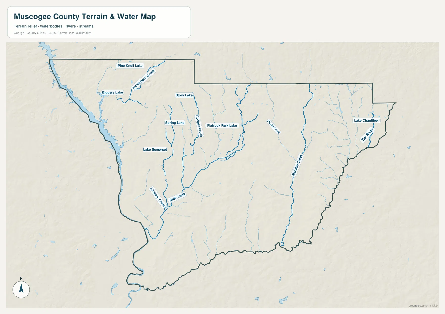
The water map is appropriate for locating named water features and comparing them with the county boundary, but it is not a flood-risk, navigation, depth, or property-boundary product. If a project depends on current hydrologic conditions or exact regulatory limits, the map should be paired with the relevant official data rather than used by itself.
Elevation rises from low western ground to hillier northern and eastern terrain
The elevation map gives Muscogee County a very different appearance from the flatter county and city views. Its legend reports an actual elevation range of about 12 to 210 meters, with a mean of about 119 meters. Lower greens are most prominent along the west and southwest, while browns and tan shades cover more of the north and northeast and reappear on ridges through the interior.
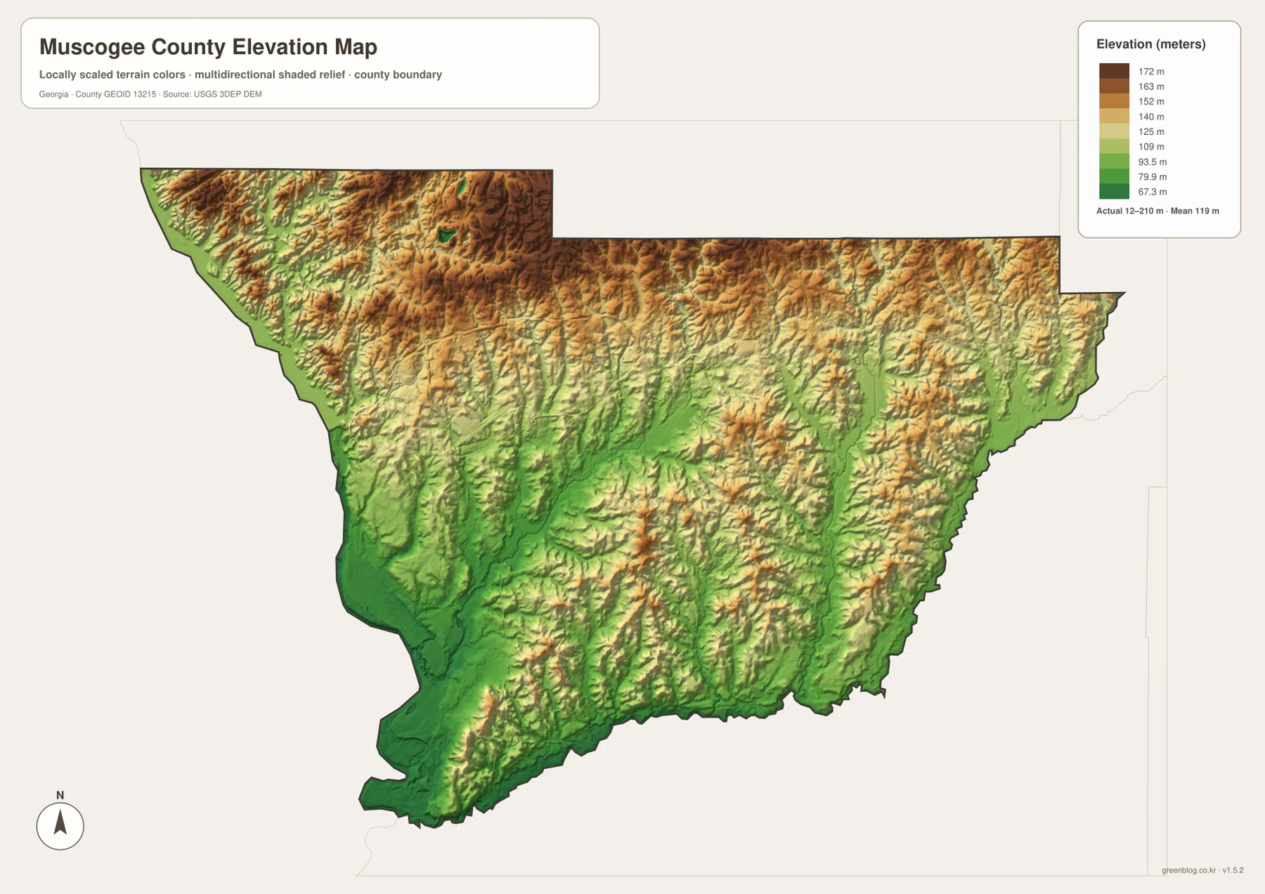
The western lowlands make sense when viewed beside the Chattahoochee and creek network, while the northern and eastern portions are broken into many small ridges and valleys. Even the central part of the county contains repeated changes in relief rather than one uniform surface. Comparing the elevation and water maps is especially useful because many of the creek corridors occupy lower bands between higher ground.
This elevation layer is intended for regional comparison, not engineering or survey work. The shaded relief makes hills and valleys easier to see, but it should not be used as a substitute for site-level measurements. Its strength is showing where the county is generally lower, where it becomes hillier, and how those differences relate to the water network.
Frequently Asked Questions
Why does the city map show Columbus as the only major city?
The supplied city layer ranks major cities rather than listing every neighborhood or small community. In Muscogee County, Columbus is the only ranked major city on that map, which highlights its dominant urban role without claiming that no other named places exist.
Can I see both the Chattahoochee context and smaller creeks on the water map?
Yes. The water map shows the western river context along with named interior features such as Cooper Creek, Baker Creek, Bull Creek, several other streams, and multiple labeled lakes. It is a reference map, not a flood or navigation chart.
What elevation range is shown for Muscogee County?
The supplied elevation map reports an actual range of about 12 to 210 meters and a mean of about 119 meters. The lowest broad areas are most visible toward the west and southwest, while higher terrain is more common toward the north and east.
Sources and reference data
The following sources provide county information or official boundary, hydrography, and elevation data that complement the supplied map set.
- Columbus Consolidated Government
- U.S. Census Bureau QuickFacts for Muscogee County
- New Georgia Encyclopedia: Muscogee County
- U.S. Census Bureau TIGER/Line Shapefiles
- USGS National Hydrography
- USGS 3D Elevation Program
Map File Information
Download the map files associated with this page for reference, printing, and compatible visual projects.
- Included Files: 4 high-resolution A3 JPG maps described on this page
- File Type: JPG files in a ZIP archive
- Intended Use: Printing, education, presentations, and map-based projects
Related Maps
Green Map creates custom-edited map images using open geographic data sources such as geoBoundaries, Natural Earth, OpenStreetMap, and government open data. These maps are edited visual materials, not raw data files, and are provided for education, documents, presentations, and graphic reference.