You can download four high-resolution JPG maps of Pennington County in one ZIP file from this page. The county stretches from the high Black Hills in the west through Rapid City and Box Elder to the much lower plains around New Underwood, Wall, and the eastern extension. The maps show roads and settlements, six ranked cities, reservoirs and major creek valleys, and an actual elevation range of about 577 to 2,184 meters. Few counties in this series show such a dramatic west-to-east change within one boundary.
Rapid City is the easiest place to begin. It anchors the western urban area, with Box Elder immediately to the east. Interstate 90 continues across the county toward New Underwood, Wasta, and Wall, while roads in the Black Hills curve through much rougher terrain around Hill City and Keystone. The road network becomes visibly straighter and more open east of Rapid City, matching the transition from mountain country to plains.
The water and elevation maps make that transition even clearer. Pactola Reservoir, Deerfield Lake, Sheridan Lake, and several smaller lakes are concentrated in the Black Hills. Rapid Creek and Spring Creek carry water eastward out of the mountains, while Boxelder Creek and the Cheyenne River system dominate farther east. On the elevation layer, brown western ridges drop quickly through the Rapid City area into broad green lowlands across the plains.
Table of Contents
Use Rapid City and I-90 to separate the Black Hills from the eastern plains
The general county map is easiest to read by locating Rapid City and I-90 first. Rapid City and Box Elder form the main western urban cluster, and I-90 then runs east through New Underwood and Wasta toward Wall. East of Rapid City, the highway follows a relatively open corridor across the plains. West and southwest of the city, the road pattern changes sharply as routes bend through the Black Hills rather than following a simple grid.
Roads 16 and 16A, U.S. 385, and routes 244 and 40 are useful references in the western mountain area, while road 79 is marked south of Rapid City. Route 44 heads southeast from the Rapid City region, and I-90 together with U.S. 14 provides the main eastward orientation. Near Wall, route 240 is another visible reference. These numbers help with location on the static map, but they do not report current construction, closures, surface conditions, or travel time.
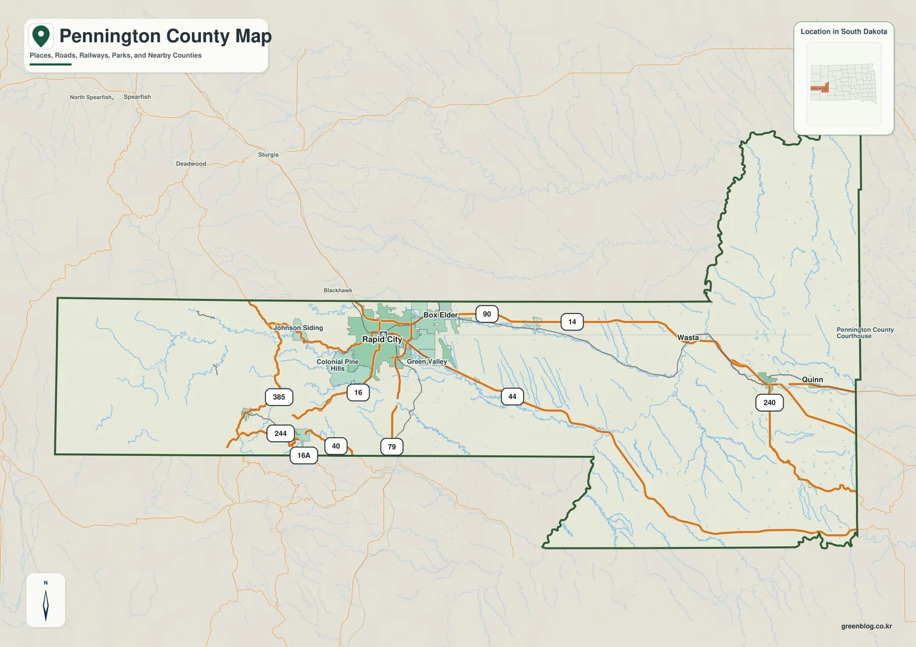
The county shape reinforces the same contrast. A long western section crosses the Black Hills, while the eastern portion expands into a larger irregular area of plains and drainage valleys. Rapid City sits close to the transition between those two landscapes. Wall and Quinn lie much farther east in lower, more open terrain, so the county boundary contains places that look very different despite being part of the same administrative unit.
Six ranked cities mark the mountain side, urban transition, and plains corridor
The city-distribution map highlights Rapid City, Box Elder, Hill City, Wall, New Underwood, and Keystone. Rapid City and Box Elder sit close together in the western urban area. Hill City and Keystone are farther southwest inside the Black Hills, while New Underwood and Wall extend eastward along the plains corridor. The city pattern therefore gives useful reference points for the county’s elevation transition as well as its settlement geography.
No connector lines or mileage values appear between the city markers. The spacing should be read as relative position rather than a measured direct or driving distance. CITY INDEX numbers identify the six cities, and the population figures shown in the legend are additional map information, but neither the index nor the visual gap between symbols should be used for route planning. Actual travel distance and time require a separate routing source.
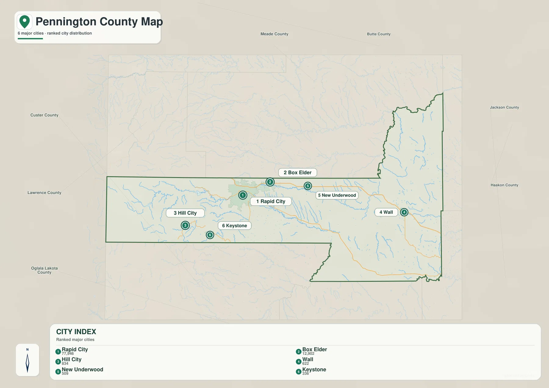
Checking the same cities on the elevation map makes the pattern especially clear. Hill City and Keystone lie close to broad high-elevation colors in the Black Hills. Rapid City sits near the zone where those colors drop toward the plains, and Box Elder begins the lower eastward transition. New Underwood and Wall are positioned in much lower terrain. The city layer is therefore useful as a set of geographic anchors rather than simply a list of population centers.
Pactola Reservoir and Rapid Creek define the Black Hills water network
The western terrain-and-water map contains a dense group of mountain reservoirs and lakes. Pactola Reservoir is the most prominent, with Deerfield Lake, Sheridan Lake, Canyon Lake, Major Lake, and Horse Thief Lake shown in separate valleys. Rapid Creek runs eastward from the mountain area, and Spring Creek forms another long drainage farther south. These features help explain why the western road network bends around ridges and valleys rather than following the open pattern seen on the plains.
East of Rapid City, Boxelder Creek becomes a long east-west water reference. Farther east, the Cheyenne River forms a major north-south valley. The northeastern extension also contains named water features such as Deep Creek, Hammann Lake, Pierce Lake, and Shearer Lake. The water map therefore changes from reservoirs and steep mountain creeks in the west to broader river valleys and numerous smaller plains tributaries in the east.
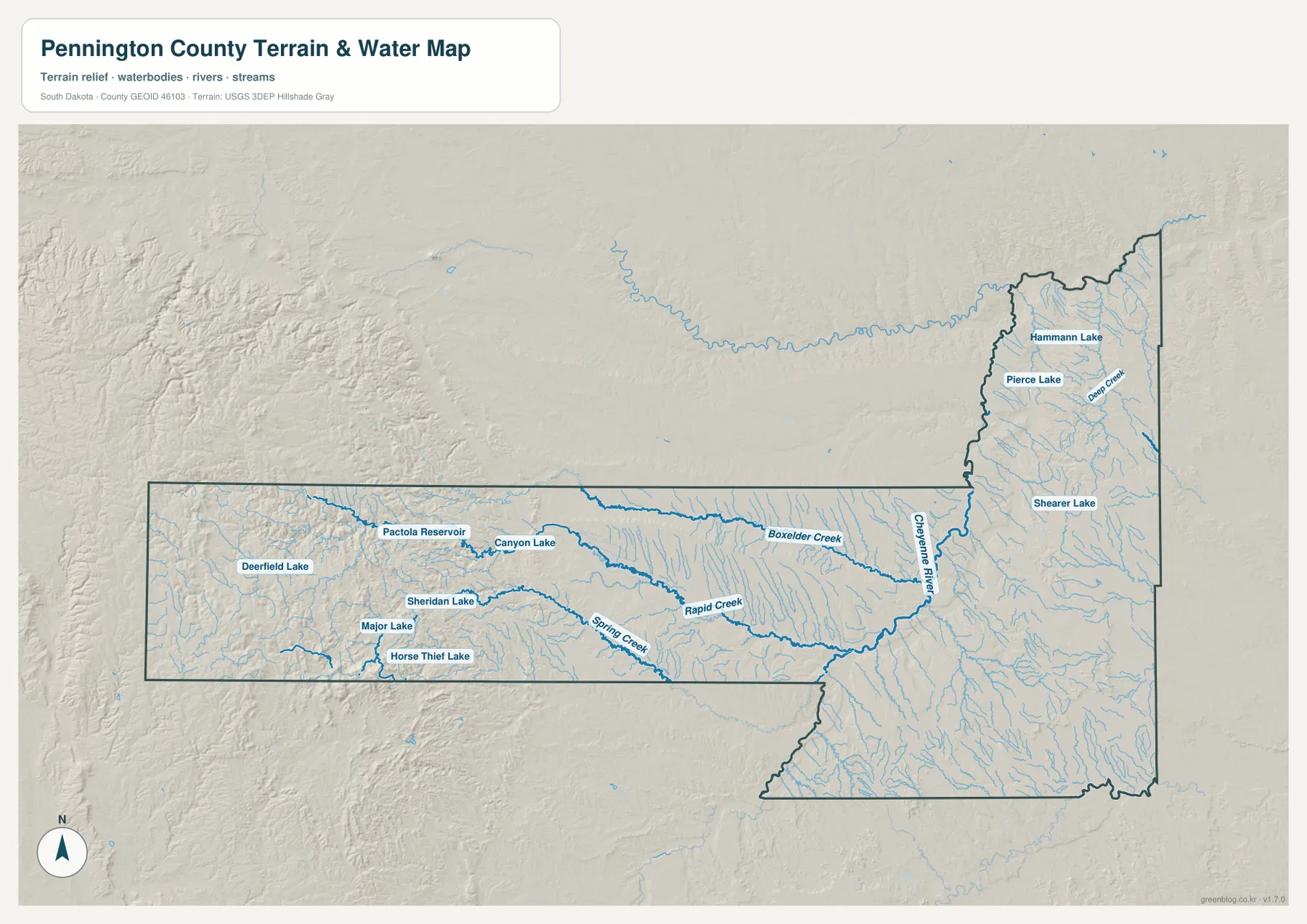
This water layer is intended as a geographic reference for stream, river, reservoir, and lake names and locations. It does not show real-time flow, water depth, water quality, flood zones, or navigability, and a blue line should not be treated as a parcel or legal boundary. For current hydrographic source data, consult an authoritative dataset such as USGS National Hydrography.
Elevation spans about 577–2,184 m, making the west-to-east drop the defining terrain feature
The elevation legend reports an actual county range of about 577 to 2,184 meters with a mean near 1,085 meters. The difference between the listed minimum and maximum is roughly 1,607 meters. Dark brown and tan colors dominate the Black Hills in the west, where large areas rise well above 1,500 meters. The colors drop quickly through the Rapid City transition, and most of the eastern plains appear in green tones associated with much lower elevations.
The western highlands are deeply cut by valleys. Rapid Creek and Spring Creek form lower corridors between high ridges around the Hill City and Keystone region. Rapid City is close to the break between rugged mountain relief and the flatter plains. Farther east, Boxelder Creek and the Cheyenne River occupy broad low corridors, while the Wall and New Underwood areas are much lower and more open than the Black Hills side.
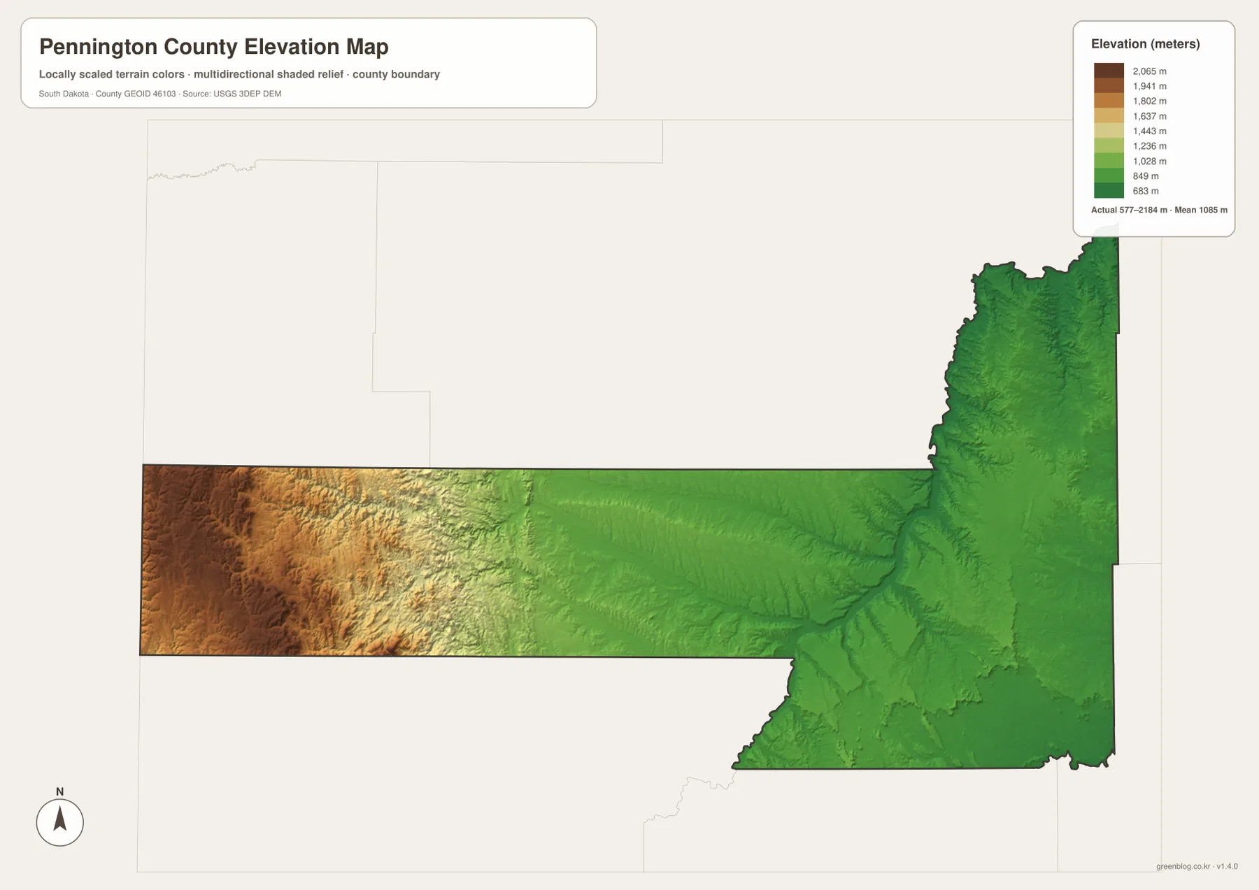
The elevation colors are designed for broad county-scale comparison, not site measurement. An exact elevation for a road point, building site, field corner, or engineering location should come from an official DEM source such as the USGS 3D Elevation Program or from an appropriate survey.
Compare Hill City and Wall to see the county’s full terrain change
Hill City is a useful western reference. On the city map it lies southwest of Rapid City inside the Black Hills, and the water map places it near Pactola Reservoir, Deerfield Lake, Sheridan Lake, and several mountain creeks. The elevation layer is dominated by high brown and tan colors around this side of the county. Curving roads such as U.S. 385 also reflect the rugged terrain.
Wall provides the opposite comparison in the east. It sits near I-90 and route 240 on the general map and is far removed from the reservoir-rich Black Hills. On the elevation layer, broad green lowlands surround the Wall area, while the water map emphasizes plains streams rather than mountain lakes. Moving back and forth between Hill City and Wall across all four maps shows why Pennington County cannot be described by one terrain type.
The WebP images in the article are optimized for screen viewing. The download archive contains the corresponding original JPG files for the general county map, city-distribution map, terrain-and-water map, and elevation map. Each JPG is 3638 × 2572 pixels, which is better suited to A3 printing, presentations, classroom materials, and closer inspection of labels.
Frequently Asked Questions
Does the city map give a distance from Rapid City to Wall or Hill City?
No. The city-distribution map shows Rapid City, Box Elder, Hill City, Wall, New Underwood, and Keystone but includes no connector lines or mileage labels. Use a separate routing or distance source when an actual straight-line or driving distance is required.
Which map best shows Pactola Reservoir and Rapid Creek?
The terrain-and-water map is the clearest choice. Pactola Reservoir, Deerfield Lake, Sheridan Lake, Rapid Creek, and Spring Creek are shown in the Black Hills, while Boxelder Creek and Cheyenne River provide major references farther east.
Can the 577–2,184 m range be used as an exact site elevation?
No. Those figures describe the county-wide elevation range, and the colored surface is intended for broad terrain comparison. Use official DEM or survey data when an exact elevation is needed at a specific location.
Map File Information
The ZIP contains the original high-resolution JPG files for the Pennington County general map, city-distribution map, terrain and water map, and elevation map.
- Included Files: 4 JPG maps
- Printable Size: 3638 × 2572 px each
Related Maps
Sources and references
- U.S. Census Bureau TIGER/Line Shapefiles – official geographic source for county boundaries and base mapping data.
- USGS National Hydrography – official source for rivers, streams, reservoirs, lakes, and hydrographic data.
- USGS 3D Elevation Program – official source for elevation and DEM products.
- 2020 Census PL County Name API – Census API that can be used to verify Pennington County and South Dakota identifiers.
Green Map creates custom-edited map images using open geographic data sources such as geoBoundaries, Natural Earth, OpenStreetMap, and government open data.
These maps are edited visual materials, not raw data files, and are provided for education, documents, presentations, and graphic reference.