Download high-resolution A3 JPG maps of Frio County, Texas from the ZIP box on this page, including the county, city, water, and elevation views shown below. Pearsall and Dilley create the clearest settlement pattern because both lie along Interstate 35, while Moore sits farther north near U.S. 57 and Bigfoot is positioned toward the northeast. The water map adds a second structure that is easy to miss on the road map: Frio River and Leona River occupy the western-central side, while Black Creek and San Miguel Creek form long drainage corridors in the east. The elevation surface ranges from about 113 to 253 meters and shows a mix of higher ridges and broad lower valleys rather than a completely flat county.
Pearsall is the best orientation point. It lies somewhat north of the county’s center and is crossed by Interstate 35, with Dilley on the same corridor near the southern edge. Moore is farther north where U.S. 57 provides an important east-west reference, and Bigfoot appears near the northeastern side of the county map. This arrangement makes the transportation pattern relatively easy to follow, but the blue stream network is much denser than the road network. Comparing the water and elevation views reveals that the open spaces between the towns contain multiple creek valleys, reservoirs, and local ridges.
Table of Contents
Pearsall and Dilley on the Interstate 35 Corridor
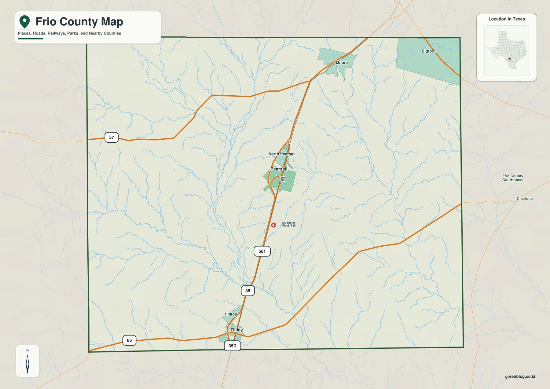
Interstate 35 is the strongest road feature on the general county map. It enters the northern part of Frio County, passes Pearsall, and continues almost straight south to Dilley. North Pearsall is labeled immediately above Pearsall, and McKinley Field appears a short distance south of town. If the goal is simply to establish the county’s principal settlement corridor, finding Pearsall and following I-35 to Dilley is the fastest way to do it.
The northern road pattern is different. U.S. 57 comes in from the west and continues toward Moore, which lies north of Pearsall. The route approaches the Interstate 35 area near the upper part of the county, giving Moore a distinct position outside the Pearsall–Dilley line. Bigfoot sits farther northeast and is also separated from the main I-35 settlement pair. The result is a county map with one dominant north-south road corridor and a smaller northern branch rather than a continuous chain of towns across the entire county.
A route labeled 85 crosses the southern area near Dilley, adding an east-west reference close to the bottom of the county. Several other numbered local roads appear around Pearsall and between Pearsall and Dilley, but the most useful hierarchy is clear at this scale: I-35 organizes the two largest cities, U.S. 57 organizes the northern approach around Moore, and the southern routes spread outward from Dilley. Beneath those roads, numerous streams cross or parallel the transportation lines, which becomes much easier to see on the water map.
A Two-City Index: Pearsall and Dilley
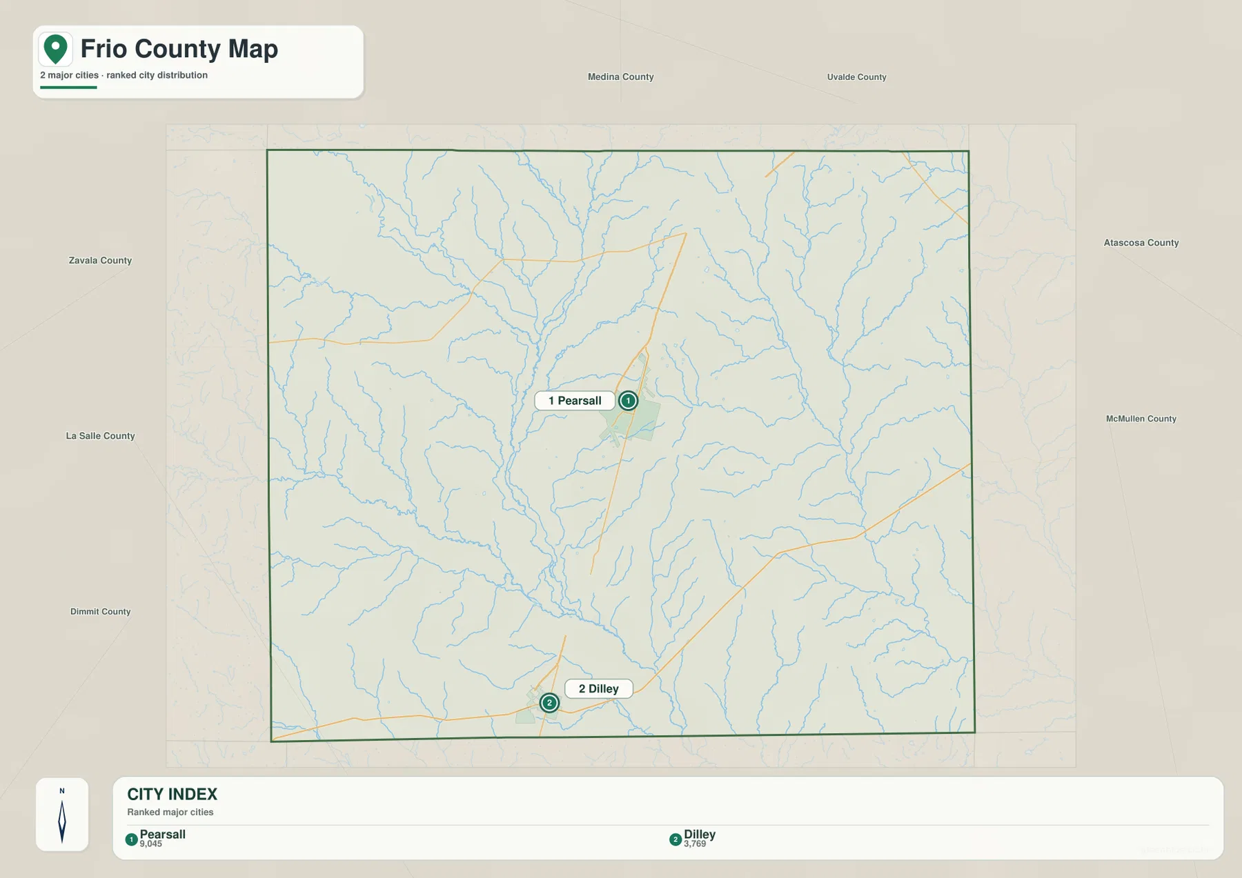
The city map highlights two major cities. Pearsall is ranked first with a displayed value of 9,045, while Dilley is second at 3,769. Pearsall appears in the north-central portion of the county and Dilley near the southern edge. The graphic does not print a straight-line mileage connector between them, so it should be used for ranking, direction, and relative spacing rather than for estimating an exact distance.
The north-south arrangement is unusually easy to compare with the general county map because Interstate 35 follows the same broad direction. Pearsall is the larger of the two ranked cities and also sits near more intersecting roads. Dilley is smaller on the city index but remains a prominent southern reference because it lies on the same interstate and near the road marked 85. This gives the two-city map a practical geographic meaning without requiring a long list of smaller communities.
North Pearsall, Moore, and Bigfoot still matter when reading the county map, but they are not part of this particular ranked city index. That distinction prevents the city view from being mistaken for a complete place-name map. Use the city graphic to establish Pearsall and Dilley first, then return to the general map for the smaller labels and road connections.
Frio River, Leona River, and the Eastern Creek Valleys
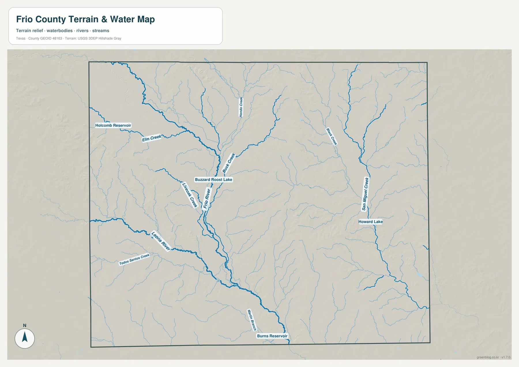
Frio River is the strongest named watercourse in the western-central part of the water map. It enters from the northwest, continues toward the middle of the county, and then runs south through a broad network of tributaries. Leona River lies to the west and southwest of the Frio channel, with Lavenock Creek shown between nearby drainage lines. Buck Creek joins the central network from the north, creating a clear concentration of watercourses west of the county’s main I-35 settlement corridor.
The northwest includes Elm Creek and Holcomb Reservoir, while Buzzard Roost Lake is labeled close to the Frio River system farther southeast. Todos Santos Creek appears in the southwest near the Leona River side, and Burns Reservoir is marked close to the southern edge. These smaller water bodies are useful location references because they break up a map that otherwise contains many similar branching tributaries.
Eastern Frio County has a separate drainage pattern. Black Creek runs southward through the northeast and east-central area, while San Miguel Creek forms a longer north-south valley farther east. Howard Lake is labeled beside that eastern creek system. Dividing the water map into a western Frio–Leona side and an eastern San Miguel side makes the network much easier to read than trying to memorize every thin tributary at once.
The water map is a geographic reference for locating streams, rivers, lakes, and reservoirs. It does not establish flood zones, legal water boundaries, stream permanence, channel depth, or navigability. Its useful contribution is showing how Pearsall and Dilley sit between several separate drainage corridors and how much of the county’s seemingly open land is actually divided by creek valleys.
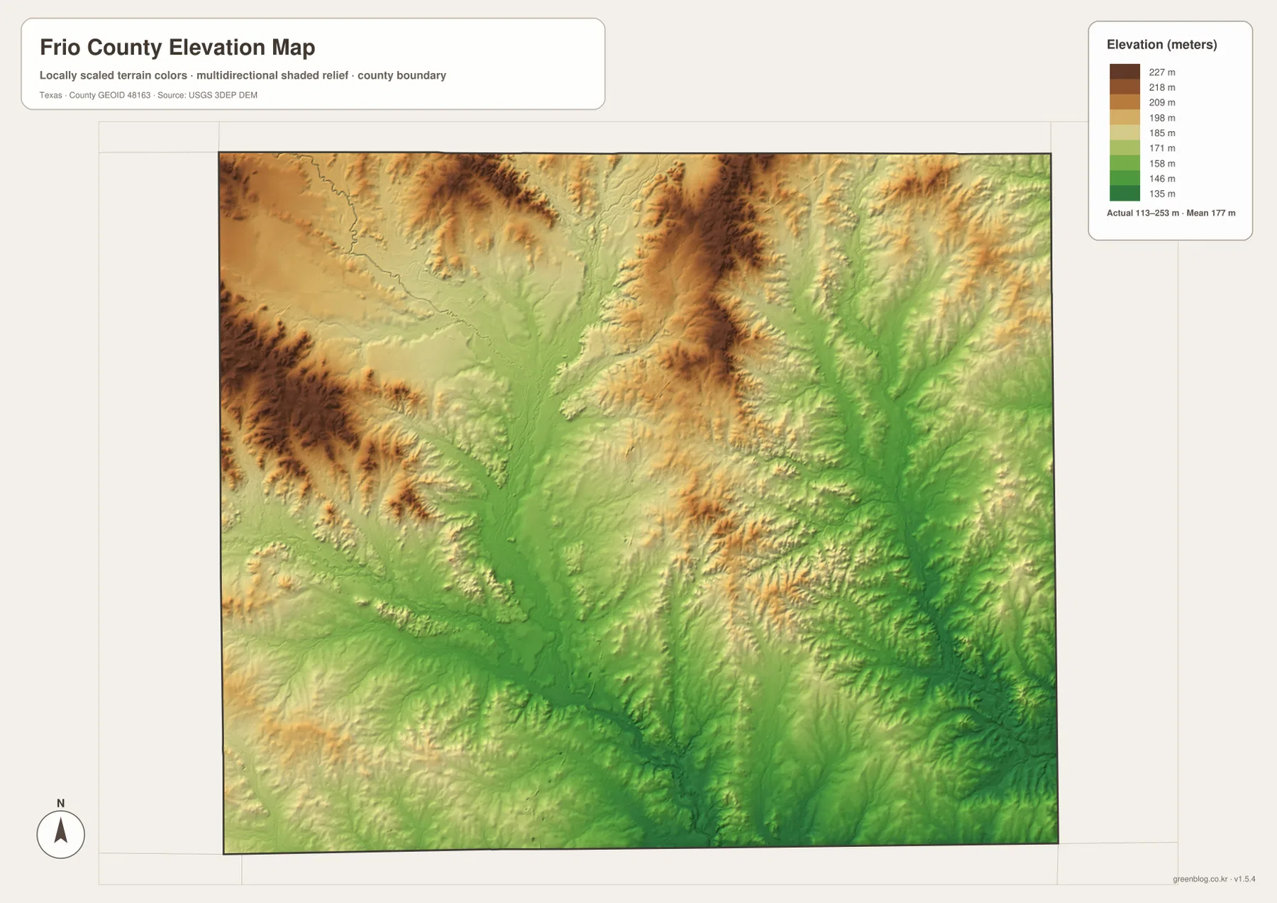
Higher Ridges and Lower Drainage Corridors Across 113–253 Meters
The elevation map lists an actual range of about 113 to 253 meters and a mean near 177 meters. Some of the strongest brown high ground appears in western and north-central parts of the county, with additional ridges along the northern edge. Lower green terrain spreads through much of the central and southeastern interior. The pattern is not a simple uniform slope; high ridges and low drainage corridors alternate across the map.
Frio River follows a broad low corridor that can be matched between the water and elevation views. The central area where tributaries converge is especially green, indicating lower terrain relative to the surrounding ridges. On the eastern side, San Miguel Creek and Black Creek also occupy elongated low valleys. Between these drainage lines, tan and brown uplands remain, producing a more varied relief pattern than the road map alone suggests.
The southern area around Dilley is generally lower than the darkest north-central ridges, but it is not completely level. Small tributaries continue to cut shallow valleys across the surface. The western side also mixes higher ground with deeply incised stream channels, so it would be misleading to describe the entire west as uniformly high. What the map clearly supports is a county with localized uplands separated by lower river and creek corridors.
The locally scaled color surface is intended for county-wide comparison. It should not be used as survey-grade elevation for a parcel, road grade, engineering design, or flood-elevation decision. For ordinary geographic reading, however, the 140-meter difference between the lowest and highest mapped points is enough to explain why the river corridors appear as broad green paths between more elevated ridges.
Pearsall Between the Frio River Side and San Miguel Creek Side
Pearsall is useful not only as a road reference but also as a dividing point between different water systems. West of the I-35 corridor, Frio River, Leona River, Buck Creek, and smaller tributaries create a dense network of valleys. The northwest also contains Holcomb Reservoir and Elm Creek. On the elevation map, many of these channels correspond to green low ground separated by higher ridges.
East of Pearsall, the water system is less tied to the Frio main stem. Black Creek and San Miguel Creek form long drainage corridors, with Howard Lake beside the eastern system. The road map first draws attention to the straight Pearsall–Dilley Interstate 35 line, but the water and elevation maps show that the land on either side of that road is organized by different valleys. This is one of the most useful ways to understand the county beyond its highway layout.
Choosing the Best Frio County Map for the Question
Use the general county map when you need Pearsall, Dilley, Moore, Bigfoot, Interstate 35, U.S. 57, or the other numbered roads in one view. The city map is the quickest option for comparing the two ranked cities and their north-south placement. Choose the water map for Frio River, Leona River, Buck Creek, San Miguel Creek, reservoirs, and lakes. The elevation view is most useful when you want to compare higher ridges with the lower drainage corridors that cross the county.
The WebP images are convenient for viewing on the page, while the ZIP below contains the matching high-resolution A3 JPG originals for printing and larger displays. The archive includes the county, city, water, and elevation maps shown here, so you can keep the full set or use only the file needed for classroom work, a presentation, local reference, or a personal map collection.
Frequently Asked Questions
How are Pearsall and Dilley positioned on the Frio County maps?
Pearsall is in the north-central portion of the county and Dilley is near the southern edge. Interstate 35 runs through both, making their north-south relationship especially clear on the general county map.
Where does the Frio River appear within the county?
On the supplied water map, Frio River enters from the northwest, continues through the western-central interior, and runs south through a dense tributary network. Leona River and Buck Creek are nearby, and the elevation map shows lower terrain along much of the same drainage corridor.
What elevation range is shown on the Frio County elevation map?
The map lists an actual range of about 113 to 253 meters and a mean near 177 meters. Higher ridges are prominent in parts of the west and north-central county, while river and creek valleys form lower corridors through the center and east.
Sources and Reference Data
USGS The National Map Viewer — Official map service for roads, terrain, hydrography, and other geographic layers.
USGS National Hydrography — Official reference for rivers, streams, lakes, reservoirs, and hydrographic data.
USGS 3D Elevation Program — U.S. Geological Survey program for elevation and terrain data.
U.S. Census Bureau TIGER/Line Shapefiles — Official source for county boundaries, roads, and related base geography.
Map File Information
Download the Frio County county map, city map, water map, and elevation map as high-resolution A3 JPG files. The ZIP contains the original map files shown on this page.
- File Type: JPG
Related Maps
- Atascosa County Texas map
- Zavala County Texas map
- Webb County Texas map
- Bandera County Texas map
- Uvalde County Texas map
Green Map creates custom-edited map images using open geographic data sources such as geoBoundaries, Natural Earth, OpenStreetMap, and government open data.
These maps are edited visual materials, not raw data files, and are provided for education, documents, presentations, and graphic reference.