Bandera County has an unusual outline, a clearly marked road center at Bandera, a dense network of river branches in the west, and a sharp change from higher western ridges to lower ground in the southeast. On the supplied county map, Bandera sits east of the county’s geographic middle where routes 16 and 173 meet, while Lakehills and Lake Medina Shores appear in the narrow southeastern part of the county. The four map files on this page are also available as one ZIP containing four high-resolution A3 JPGs, so the same material can be used on screen or downloaded for printing, classroom work, and local reference.
The maps separate information that would be crowded if everything were placed on a single sheet. The general county map emphasizes roads, nearby places, and the county boundary. The city view strips away most detail and marks Bandera as the single ranked major city. The terrain-and-water sheet gives the Medina River and its branches far more space, while the elevation map shows an actual county range of about 318 to 719 meters, with a mean of about 508 meters. Reading those views together makes the county’s geography much easier to understand than relying on a road map alone.
Table of Contents
Bandera is the clearest road reference point inside the county
Bandera is the most prominent place label on the general map and lies in the east-central part of the county rather than at its exact center. Route 16 runs through the area on a north-south line, and route 173 approaches from the north before continuing through the Bandera area. The Bandera County Sheriff’s Office is also marked nearby, which helps identify the administrative center without adding a separate city inset. From Bandera, the county extends much farther west than east, so using the town as the starting point makes the rest of the map easier to orient.
A route 689 marker appears farther north, while the eastern side of the map shows route numbers 46 and 475 near the county’s pointed edge and the surrounding Boerne area. These labels are useful because the eastern boundary narrows and changes direction more abruptly than the long western side. The general map also shows Center Point and Comfort north of the county, Boerne to the east, Vanderpool to the west, and Utopia to the southwest. They are useful outside reference points, but the county boundary should always be checked before assuming that a nearby place label is inside Bandera County.
The southeastern pocket has a different appearance from the broad western half. Lakehills and Lake Medina Shores are labeled close to a large water area, and the county line bends around this narrower section before turning back toward the east. In contrast, the western half contains few large road labels and many small drainage lines. That visual difference is one reason the general map works well as an orientation sheet: it quickly separates the Bandera road center, the southeastern lake communities, and the less road-dense western country.
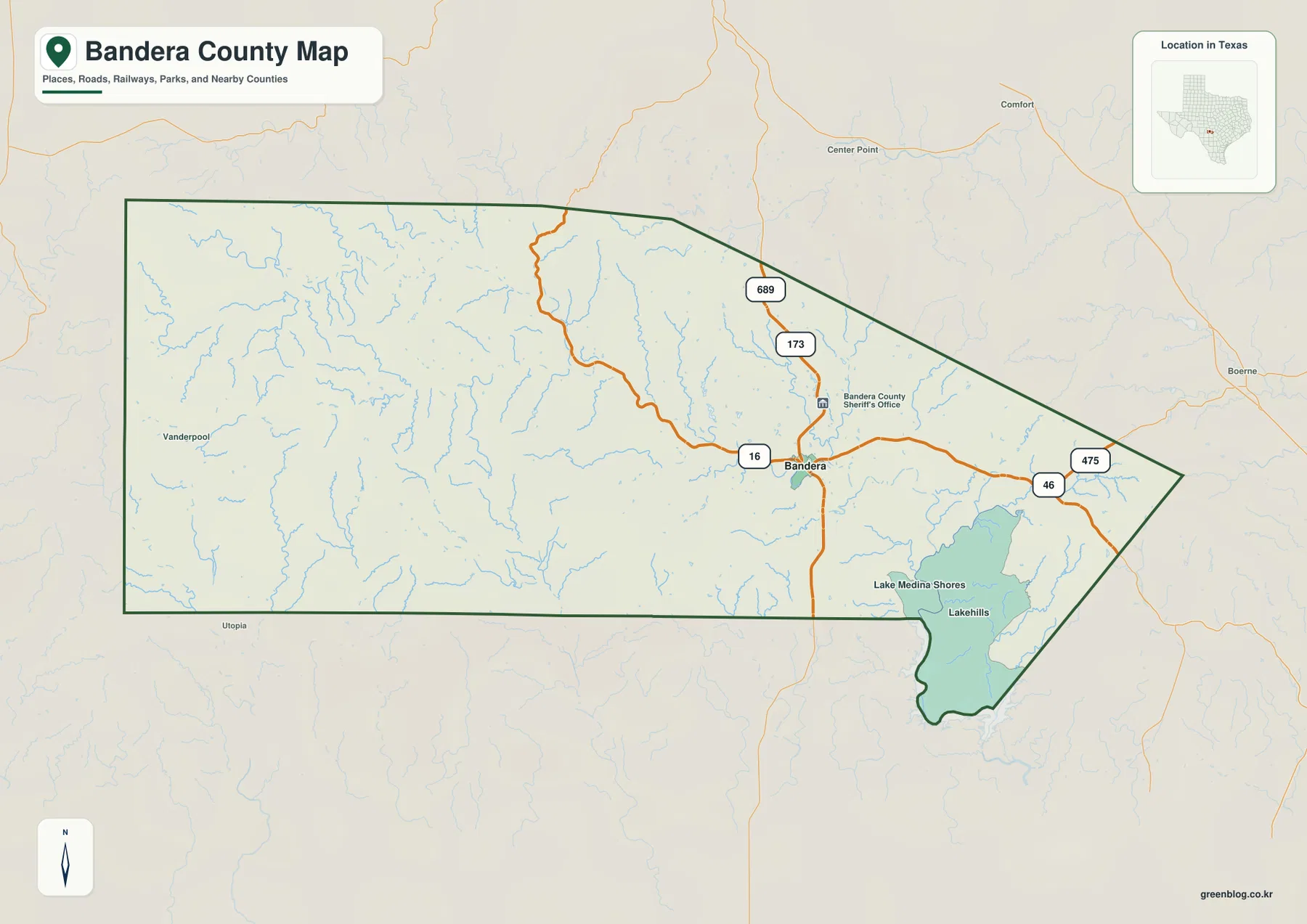
This first map is best for answering simple location questions. It shows where Bandera sits relative to the county edges, how the main numbered roads approach the town, and where the southeastern communities lie. It is less useful for identifying every named creek or comparing ridge heights, because those subjects are deliberately handled by the water and elevation sheets later in the article.
The city view reduces the county to one ranked center: Bandera
The city map is intentionally sparse. Its city index contains one ranked major city, Bandera, and the map places a single numbered marker at that location. This does not mean the county has no other communities. Lakehills and Lake Medina Shores, for example, appear on the more detailed general map. Instead, the city sheet is designed to show the dominant ranked city without letting roads, streams, or smaller place names compete for attention.
The simplified view also makes Bandera’s east-central position obvious. A large area of the county stretches west of the marker, while the boundary becomes narrower toward the southeast. The surrounding county labels add useful regional context: Kerr County is to the north, Kendall County to the northeast, Bexar County to the east, Medina County along the south and southeast, Uvalde County to the southwest, and Real County to the west. This is especially helpful when explaining Bandera County to someone who knows the neighboring counties better than the local road system.
Because the map does not try to act as a street guide, it should not be used to estimate driving time or find a detailed route. Its strength is comparison. A reader can see that Bandera is not centered within a simple rectangle and can understand how the county is wedged between several differently shaped neighbors. For presentations, short geographic introductions, or a clean locator image, the lack of extra detail is an advantage rather than a limitation.
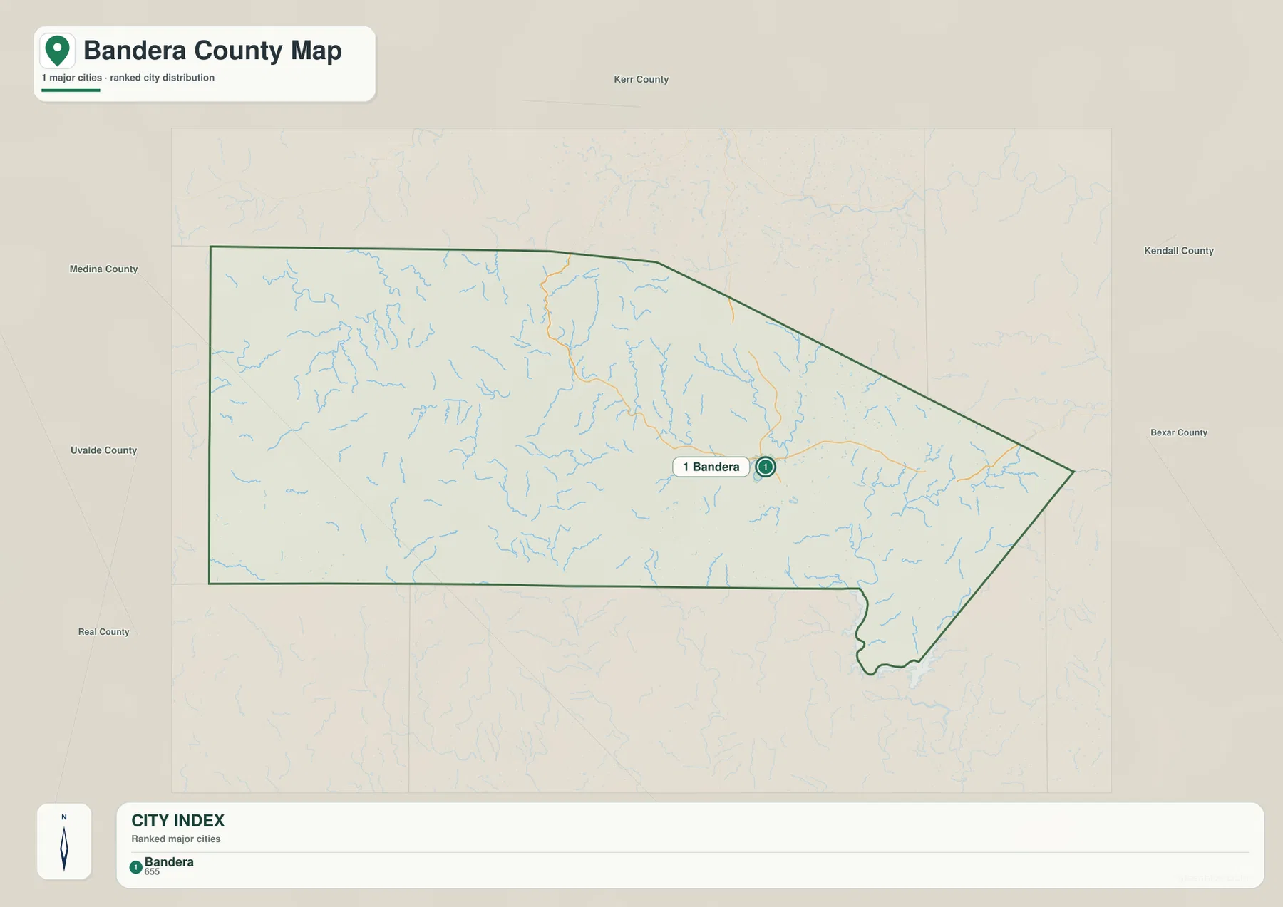
For a county page, this view is also a useful reminder that “major city” is a map category, not a complete settlement list. The general map and the city map answer different questions. One preserves more local labels and roads, while the other highlights the strongest urban reference point and the county’s position among its neighbors.
Medina River branches reveal how deeply the western terrain is divided
The terrain-and-water map changes the emphasis completely. The Medina River is the main named river running across the county, but its western branches are just as important for understanding the shape of the land. North Prong Medina River winds across the northwest, with S Fork North Prong Medina River entering from farther south. West Prong Medina River approaches from the west-central hills and joins the main Medina system. Together, these channels show that the western half is crossed by many valleys rather than being one continuous high surface.
Another major named stream, the Sabinal River, appears along the southwestern side on a mostly north-south course. Little Creek is labeled nearby, while Winans Creek and Hondo Creek appear farther east and south. On the eastern side, Red Bluff Creek is labeled close to the pointed county edge, and Elm Creek appears in the southeast. Many additional blue tributary lines are unnamed at this map scale, creating a dense drainage network that is easy to overlook on the road-focused sheet.
Several lakes provide smaller landmarks within that network. Lake Thallman, Mosher Big Lake, and Lake Hiawatha are labeled around the central and eastern Medina River corridor, while Voss Lake appears farther to the southwest. Their labels are useful for orientation, but the map does not claim that every water body has the same size, depth, permanence, or legal status. The sheet is best treated as a geographic reference for where named water features lie relative to the river system and county boundary.
The shaded relief behind the water lines is important too. Narrow ridges and valleys are especially visible in the west, and the blue channels often follow the lower spaces between those ridges. That visual relationship helps explain why the water map contains so many bends and short tributaries. It also prepares the reader for the elevation map, where the same western area appears much higher and more rugged than the southeastern part of the county.
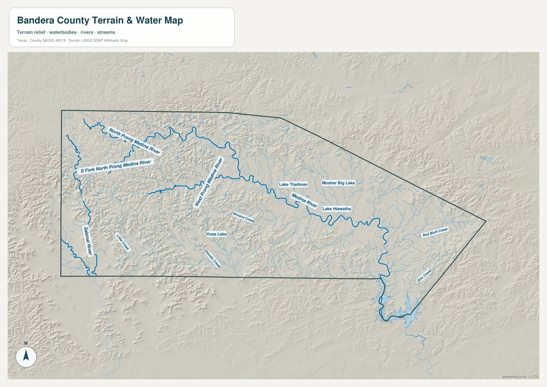
This water sheet is not a floodplain map and should not be used to decide whether a particular property is flood-prone or subject to a water-related regulation. It does not show real-time water levels either. Its value is broader: tracing the named river branches, seeing how many smaller channels occupy the western hills, and comparing those natural features with the places and roads shown on the other maps.
Elevation drops from the rugged west toward the lower southeastern pocket
The elevation map gives an actual mapped range of about 318 to 719 meters and lists a county mean near 508 meters. Brown and orange tones dominate much of the west and northwest, indicating higher ground. Green tones spread across the east-central and southeastern areas, marking lower elevations. The contrast is strong enough that the county no longer looks like a single uniform upland once the road labels are removed.
The western high ground is also heavily textured by shaded relief. Closely spaced ridges and valleys repeat across a broad area, especially near the western and northwestern edges. Lower corridors cut between them, matching the complex stream network visible on the terrain-and-water map. The elevation sheet therefore adds meaning to the blue drainage lines: the branches are not scattered randomly, but occupy lower terrain within a landscape of recurring ridges.
Moving east, the color becomes greener and the relief looks broader and less continuously high. The narrow southeastern extension contains some of the lowest tones on the map and corresponds to the same general direction where Lakehills and Lake Medina Shores appear on the road map. This west-to-southeast change is one of the clearest county-specific patterns in the supplied material. It is visible without needing to know the exact height of every ridge.
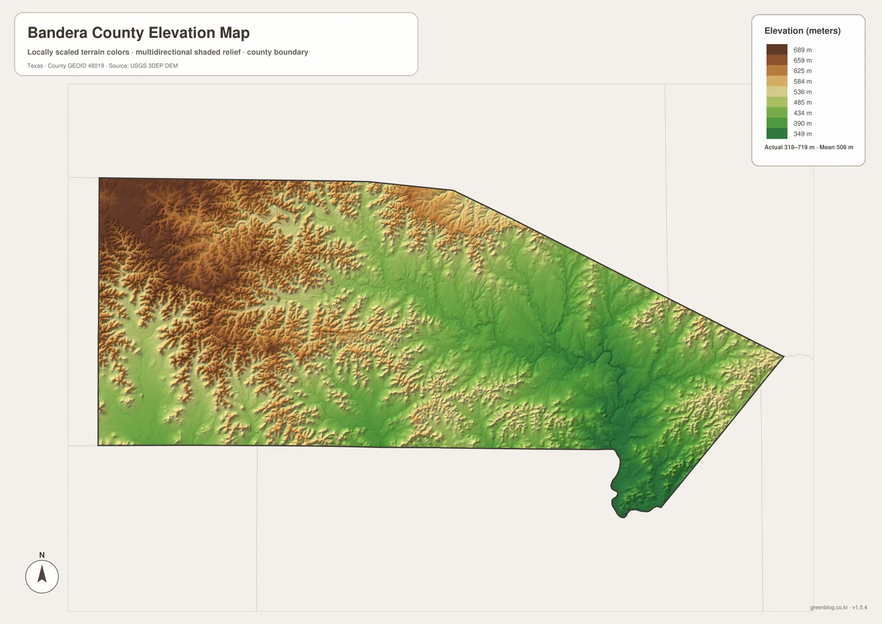
The color scale is designed for county-wide comparison, not site engineering. A house lot, road cut, drainage channel, or construction project may require much more precise elevation data than this image provides. For those purposes, original elevation datasets or a professional survey should be consulted. Here, the map is most useful for seeing the broad contrast between western high ground, lower river corridors, and the southeastern low area.
The county boundary explains why nearby labels can look deceptively close
Bandera County’s outline is one of the more useful clues on every sheet. The western side is broad, the upper boundary angles downward toward the east, and the county narrows into a pointed eastern side before extending into a small southeastern pocket. Because nearby towns and roads are drawn beyond the dark county line on the general map, a place can appear visually close to Bandera County even when it lies outside the boundary.
Center Point and Comfort are shown north of the boundary, and Boerne appears to the east. Vanderpool is labeled to the west and Utopia to the southwest. These outside labels are useful for orientation, especially when paired with the city map’s neighboring-county names. They should not be read as a complete list of surrounding communities, and they should not replace the county outline when the question is whether a location is actually inside Bandera County.
The southeastern area deserves particular attention because its boundary is narrow and curved compared with the rest of the county. Lakehills and Lake Medina Shores sit close to the large mapped water area and near the Medina County side. A quick glance can make this area look detached from the main body, but the dark outline shows the connection. That shape is easier to understand when the general map, city map, and elevation map are viewed together.
Use the map that matches the question instead of forcing every detail onto one page
For road and place orientation, start with the general county map. It is the only one of the four that combines Bandera, Lakehills, Lake Medina Shores, nearby outside towns, and the most visible numbered routes on a single sheet. If the purpose is simply to show the county’s main ranked city and its position among neighboring counties, the city map is cleaner because it removes most of the competing detail.
Natural features call for a different pair. The terrain-and-water map is the best choice for following Medina River, North Prong, West Prong, Sabinal River, and the smaller named creeks. The elevation map is better for explaining why that water network is so dense in the west and why the southeastern end looks different. Side by side, they connect the river system with the higher ridges and lower corridors that shape the county.
These differences also matter when preparing printed material. A road-and-place handout is easier to read when the general map is used by itself. A geography lesson can pair the water and elevation sheets without distracting the reader with highway symbols. A short county locator can use the city map because Bandera and the neighboring counties remain easy to see at smaller sizes. Choosing the map by purpose keeps labels legible and avoids turning one page into an overloaded reference sheet.
The downloadable ZIP contains four original high-resolution A3 JPG files: the county map, city map, terrain-and-water map, and elevation map. You can review the WebP versions on the page first, then download the complete set for printing or offline use. Keeping the four JPGs in one archive also makes it easier to compare the same county boundary across the different themes.
Frequently Asked Questions
Is Bandera located in the center of Bandera County?
Not exactly. Bandera is east of the county’s geographic middle, with a much larger area extending to the west. The general map places routes 16 and 173 around Bandera, and the city map makes the east-central position even clearer by showing Bandera as the only ranked major-city marker.
Which river branches are most visible on the water map?
Medina River is the main named river, with North Prong Medina River, S Fork North Prong Medina River, and West Prong Medina River clearly labeled in the western half. Sabinal River is also prominent in the southwest, while Winans Creek, Hondo Creek, Red Bluff Creek, and Elm Creek provide smaller reference points in other parts of the county.
Where are the highest and lowest parts of the county on this map?
The supplied elevation map shows the higher terrain mainly in the west and northwest and lower terrain toward the east-central and southeastern areas. Its actual mapped range is about 318 to 719 meters, with a mean near 508 meters. Those values are suitable for broad county comparison, not for parcel-level surveying or construction decisions.
Sources and Reference Data
The following official sources are useful when a reader needs the underlying boundary, hydrography, or elevation data rather than a general-purpose map image. They are also appropriate starting points for work that requires more precision than the downloadable overview maps.
- Bandera County official website — county government and local information
- Handbook of Texas: Bandera County — county geography and regional background
- U.S. Census Bureau TIGER/Line Shapefiles — official geographic files used for county and related boundary reference
- USGS National Hydrography — authoritative hydrography reference for rivers, streams, and water features
- USGS 3D Elevation Program — official elevation data for more detailed terrain work
Map File Information
The Bandera County county map, city map, terrain-and-water map, and elevation map are bundled as four high-resolution A3 JPG files in one ZIP archive.
- Included Files: County map, city map, terrain-and-water map, and elevation map — 4 JPGs
- File Type: ZIP archive
Related Maps
Green Map creates custom-edited map images using open geographic data sources such as geoBoundaries, Natural Earth, OpenStreetMap, and government open data.
These maps are edited visual materials, not raw data files, and are provided for education, documents, presentations, and graphic reference.