Blanco County is easiest to understand when its roads, towns, rivers, and Hill Country relief are read together. Johnson City sits near the middle of the county where U.S. 281 and U.S. 290 meet, Blanco lies farther south on U.S. 281, and Round Mountain marks the northern side of the same general corridor. The maps on this page separate those relationships into a county map, a city-connection map, a water map, and an elevation map, and the original four A3 high-resolution JPG files are available together in one downloadable ZIP.
The county does not look like a single flat service area once the waterways and relief are added. The Pedernales River crosses the north-central part of the county, while the Blanco and Little Blanco rivers define a different drainage direction in the south. An elevation range of about 218 to 580 meters adds another layer: higher ridges stand out mainly across the western and west-central side, while lower valleys become more common toward the east. Starting with Johnson City, then moving south to Blanco and north to Round Mountain, gives a clear framework for reading all four maps.
Table of Contents
Johnson City, Blanco, and Round Mountain Set the County’s Main Road Frame
The county map places Johnson City near the central road junction that organizes much of the page. U.S. 281 runs north–south through the county, connecting Round Mountain, Johnson City, and Blanco in sequence, while U.S. 290 crosses Johnson City and provides the clearest east–west reference. That simple arrangement is useful because much of the rest of Blanco County is represented by smaller roads, creeks, and rolling terrain rather than by a dense pattern of large towns.
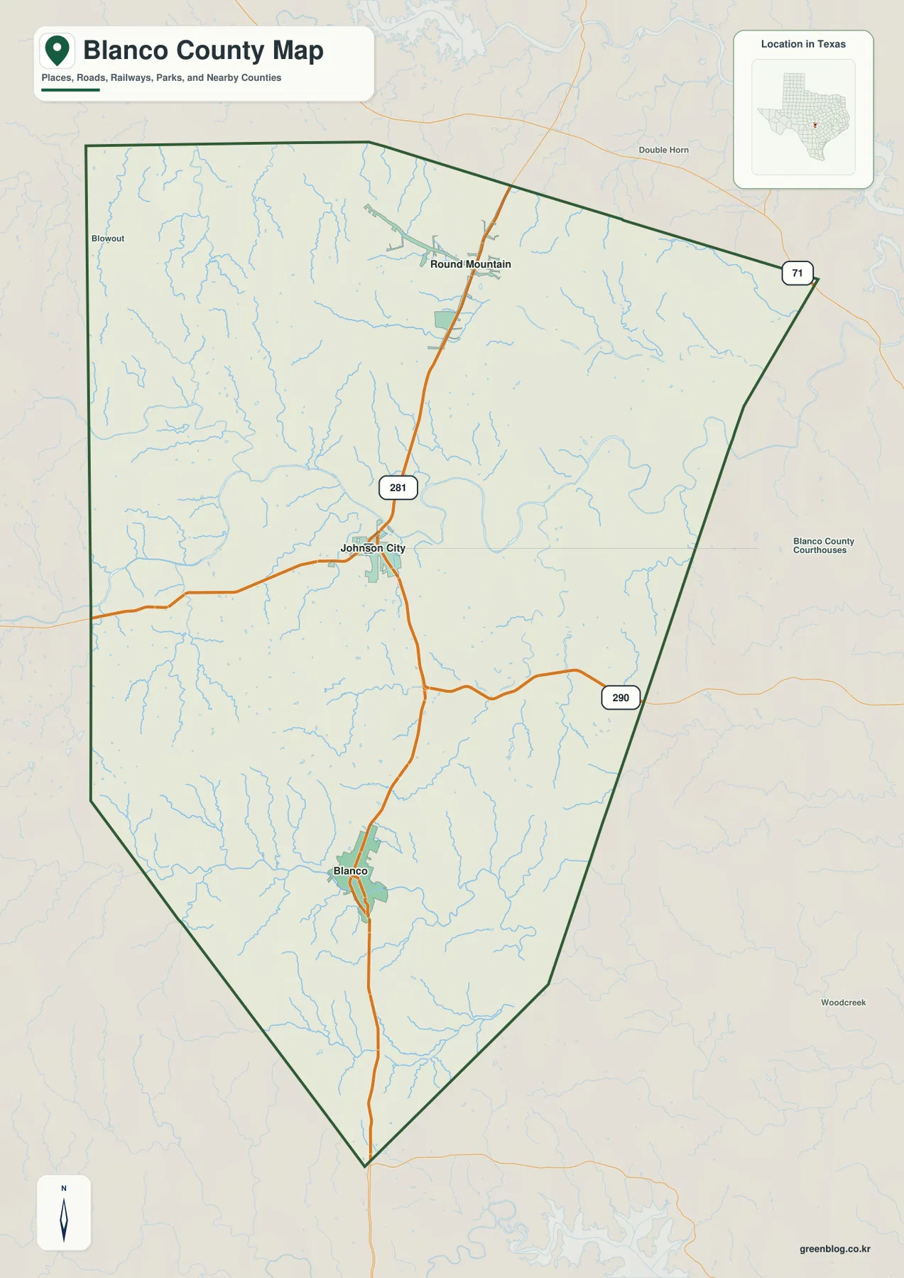
This mapped relationship agrees with the county-specific references supplied for the rewrite. Johnson City is the county seat and is described by the Handbook of Texas as being at the junction of U.S. 281 and U.S. 290. Blanco is about twelve miles south of Johnson City along U.S. 281. The map therefore gives a direct way to distinguish administrative importance from simple geographic placement: Johnson City is the seat, but Blanco and Round Mountain remain essential reference points for the southern and northern portions of the county.
The surrounding labels also show that Blanco County sits among several Hill Country counties rather than at the edge of an isolated region. Burnet County lies to the north, Hays and Travis are on the eastern side, Gillespie is to the west, and Kendall, Comal, and Llano appear around the remaining sides. For a reader planning a regional comparison, those names matter because roads and watersheds continue beyond the county line even when the map’s dark green boundary stops.
U.S. 281 Creates the North–South Spine; U.S. 290 Changes the Travel Direction at Johnson City
U.S. 281 is the easiest road to use as an orientation line. From Blanco, it runs north toward Johnson City and then continues toward Round Mountain. A visitor who has only the basic county map can use that one highway to establish the order of the three main labeled communities before looking at any smaller roads. U.S. 290 then adds a second direction at Johnson City, making the county seat a practical reference point even for someone who is not interested in administrative geography.
The surrounding blue stream lines explain why the road network should not be read as if it crossed a flat plain. Small valleys and ridges are visible throughout the county, and the major highways pass through rather than erase that terrain. On a printed copy, it can be useful to mark U.S. 281 first, add U.S. 290 at Johnson City, and then trace the Pedernales and Blanco rivers. That sequence makes the relationship between transportation and physical geography much clearer than highlighting every road at once.
For local comparison, the two highways answer different questions. U.S. 281 is best for seeing how the southern and northern communities line up, while U.S. 290 is more useful for understanding Johnson City’s connection across the upper half of the county. Neither road should be treated as a complete picture of travel, but together they provide a stable frame for reading the smaller creek valleys and neighboring-county directions shown elsewhere on the maps.
The City Map Uses Blanco as a Hub, with 12 and 23 Mile Straight-Line Links
The city-connection map needs one important clarification: its “Hub city: Blanco” label does not mean that Blanco is the county seat. Johnson City holds that role. Blanco is simply the selected hub for this particular diagram, allowing the map to compare its position with Johnson City and Round Mountain in a cleaner way than the full county map can.
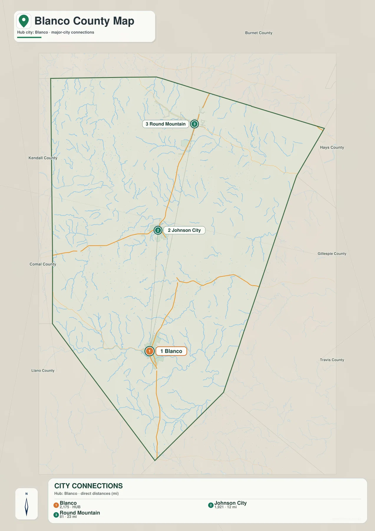
The diagram labels Johnson City at about 12 miles from Blanco and Round Mountain at about 23 miles. These are straight-line distances, not driving distances, so they should not be used to estimate mileage along U.S. 281 or travel time. Their value is comparative: Johnson City is roughly half as far from Blanco as Round Mountain is when measured directly, and both lie to the north of the hub.
When the city map and county map are viewed together, the direct-distance layout becomes more useful. The city map removes road detail and emphasizes separation, while the county map restores the actual highway corridor and the irregular boundary. This pairing is especially helpful for classrooms, reports, or regional orientation because it prevents a straight connector line from being mistaken for a road while still showing the overall settlement pattern clearly.
The Pedernales and Blanco Rivers Divide the County into Two Major Drainage Directions
The water map is dominated by two different river systems. The Pedernales River crosses the north-central area and gathers water from a broad network of creeks, while the Blanco River and Little Blanco River occupy the southern part of the county. This is more than a naming difference. The Handbook of Texas notes that roughly the northern and central two-thirds of the county drain toward the Colorado River system through the Pedernales and creeks such as Miller and Cypress, while the southern third drains toward the Guadalupe River system through the Blanco and Little Blanco rivers.
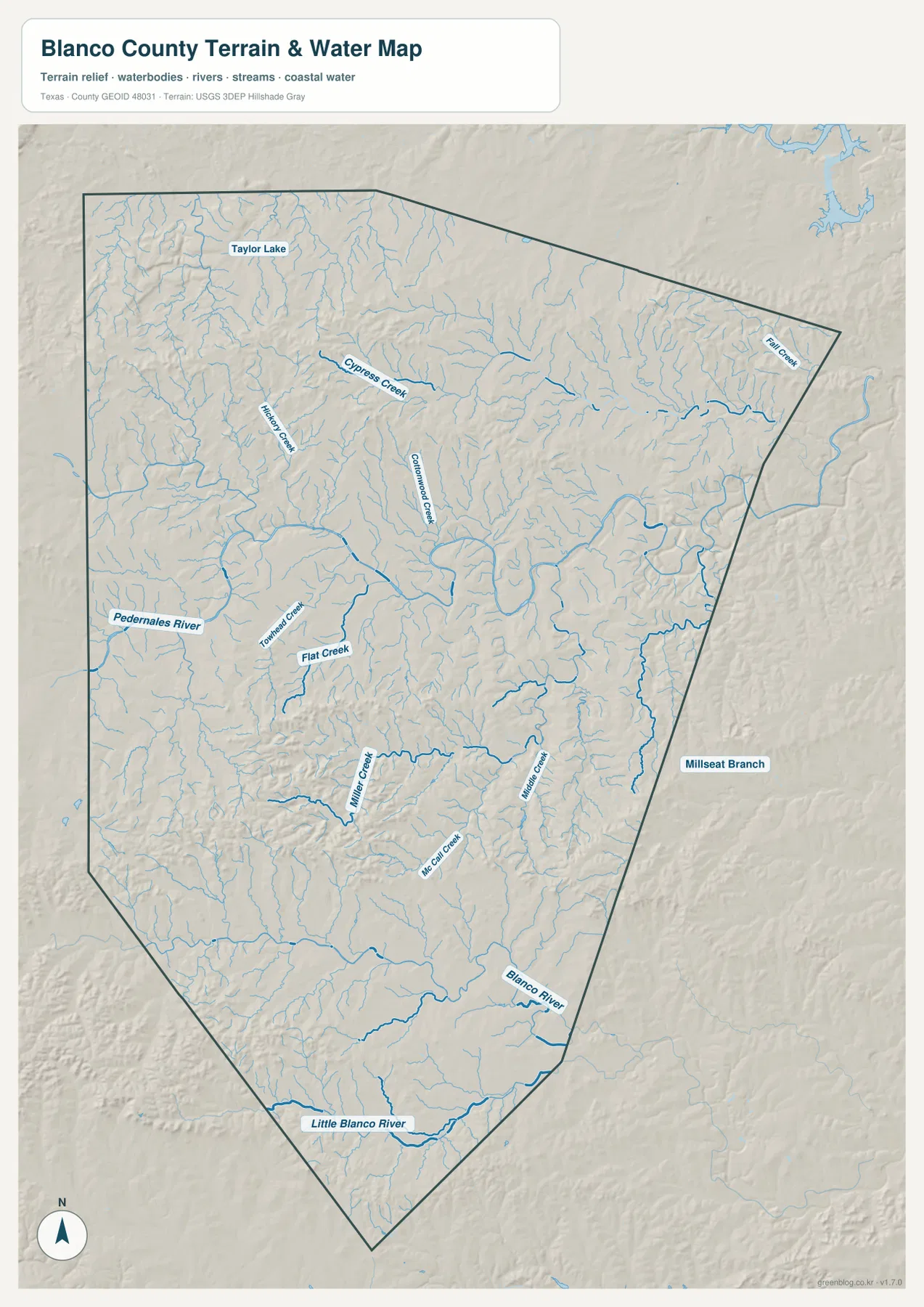
Several smaller names make that division easier to follow. Cypress Creek, Hinds Creek, Cottonwood Creek, Town Creek, Flat Creek, Miller Creek, and Fall Creek are labeled across the map, and Taylor Lake appears in the northwest. These features should not be treated as decorative detail. When a creek is traced from a higher ridge into a larger river, it shows how the county’s short, branching valleys fit into the broader drainage pattern.
The Pedernales River also has a strong physical-geography context in this part of Texas. Texas Parks and Wildlife describes the river at Pedernales Falls State Park as flowing across layered limestone, with a noticeable drop through the falls area. That description helps explain why a terrain-and-water map is useful here: the river is tied closely to the bedrock and relief of the Hill Country rather than simply crossing a smooth surface. The map on this page is a geographic reference, however, not a flood-hazard, navigation, or real-time water-condition product.
For readers comparing the two main towns, the southern water system is also important. Blanco sits close to the Blanco River, while Johnson City is associated with the Pedernales side of the county. The river map therefore adds a second way to distinguish the two places beyond their twelve-mile separation on the city diagram: they occupy different parts of the county’s larger drainage framework.
A 218–580 Meter Elevation Range Reveals Ridges in the West and Lower Valleys to the East
The elevation map uses a locally scaled color range and lists an actual county range of about 218 to 580 meters, with a mean near 409 meters. Higher brown and tan surfaces stand out across the western and west-central ridges, while greener lower terrain becomes more common toward the eastern and northeastern drainage valleys. The result is not one dominant mountain chain, but a repeating Hill Country pattern of uplands cut by narrow stream corridors.
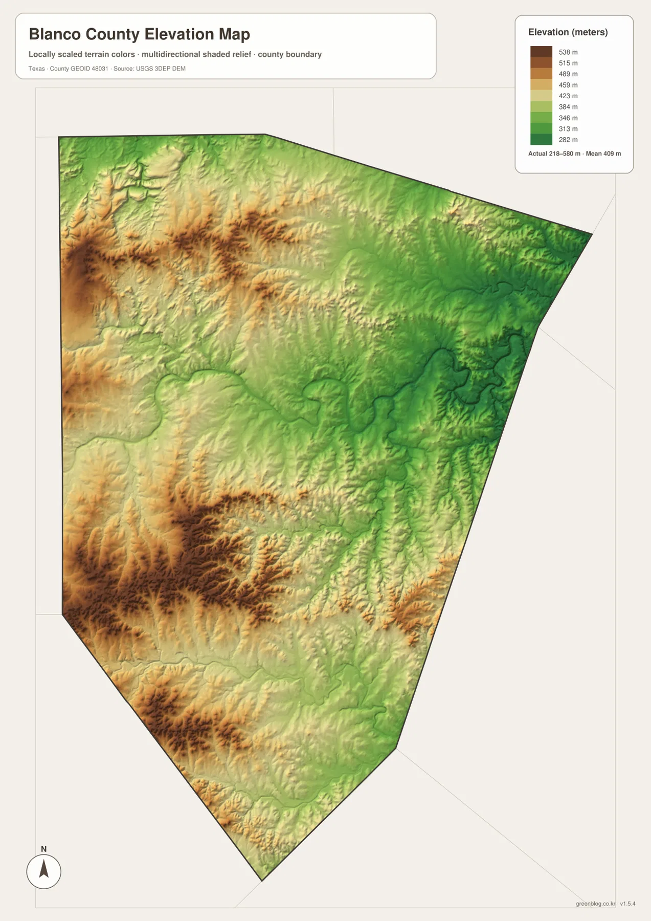
Comparing the elevation and water maps is especially useful because many of the blue creek lines occupy the lower green corridors. The Pedernales drainage creates a visible network through the north-central county, while the Blanco and Little Blanco systems follow lower ground in the south. Higher ridges between those waterways help separate adjacent drainage paths, so relief is part of the explanation for the two-basin pattern rather than a separate topic.
The elevation surface is generalized for county-scale reading and should not be treated as survey-grade or engineering-grade measurement. It is well suited to comparing broad ridges, valleys, and river settings, but a parcel, building site, bridge, or construction project requires more precise source data. The U.S. Geological Survey 3D Elevation Program is the appropriate starting point when exact elevation data are needed.
Choose the Map by the Question: Roads, Town Spacing, Water, or Relief
The county map is the best first choice when the question is “Where are Johnson City, Blanco, and Round Mountain, and how do U.S. 281 and U.S. 290 connect them?” It keeps roads, settlement labels, county boundaries, and a light water network together. The city map is better when the goal is to compare the three places without road clutter, especially when the 12-mile and 23-mile direct distances from Blanco are the main point.
The water map becomes more useful when the question shifts from travel to drainage. Start with the Pedernales River in the north-central area, then compare it with the Blanco and Little Blanco rivers in the south. Smaller creeks such as Cypress, Miller, Flat, and Cottonwood can then be added to explain local valleys. The elevation map answers a different question: where is the county generally higher or lower, and how do those uplands and valleys relate to the stream network?
Using the four maps in sequence avoids the common problem of trying to make one map do everything. A road-oriented map can remain readable because it does not have to carry detailed elevation colors, while the elevation map can show relief without competing with town labels. For printing, teaching, or local research, selecting the map that matches the question produces a clearer page and makes the county-specific relationships easier to explain.
Frequently Asked Questions
Why does the city map use Blanco as the hub if Johnson City is the county seat?
The city diagram is designed around a selected comparison hub, and Blanco was chosen for that role. It does not indicate county-seat status. Johnson City is the county seat, while the diagram uses Blanco only to show direct straight-line separation to Johnson City and Round Mountain in a simple way.
What is the most important water feature to notice in Blanco County?
Rather than choosing only one river, notice the contrast between the Pedernales system in the north-central county and the Blanco–Little Blanco system in the south. They lead toward different larger river basins, so the water map is especially useful for understanding why the county’s drainage is divided into two broad directions.
Can the 218–580 m elevation map be used for engineering or property measurements?
No. The map is a county-scale visual reference for comparing broad ridges and valleys. It is useful for geographic orientation and for relating relief to waterways, but exact site elevation requires higher-precision source data and, where necessary, professional field measurement.
Map File Information
This ZIP contains the original A3 high-resolution JPG versions of the Blanco County boundary map, city-connection map, water map, and elevation map. Use these larger files when you need a print-ready or separate image rather than the smaller WebP previews shown in the article.
- Included Files: Use only the versions confirmed in the article and supplied images
- File Type: Use the confirmed download contents
- Intended Use: Printing, education, presentations, and map-based projects
Related Maps
- Travis County Texas map
- San Saba County Texas map
- Williamson County Texas map
- Bandera County Texas map
- Atascosa County Texas map
Sources and References
- Blanco County, Texas official website — county government and local reference information.
- Handbook of Texas: Blanco County — county history, settlement context, and the major drainage division.
- Texas Parks & Wildlife: Pedernales Falls State Park — regional context for the Pedernales River and Hill Country limestone terrain.
- USGS National Hydrography — official hydrography reference data.
- USGS 3D Elevation Program — official elevation source data.
Green Map creates custom-edited map images using open geographic data sources such as geoBoundaries, Natural Earth, OpenStreetMap, and government open data.
These maps are edited visual materials, not raw data files, and are provided for education, documents, presentations, and graphic reference.