Jasper County lies in central Georgia with Monticello as the county seat, Shady Dale in the northeast, and a broad rural interior divided by the Ocmulgee River and many creek valleys. You can download four high-resolution A3 JPG Jasper County maps from this page in one ZIP, including the county reference, city, water, and elevation versions. The previews below let you check Monticello and Shady Dale, numbered roads, the Ocmulgee River and named creeks, plus relief ranging from about 112 to 254 meters before opening the larger files.
Monticello is the easiest place from which to understand the county. It sits slightly south of the geographic middle and is surrounded by several numbered roads, while Shady Dale lies well to the northeast. Route 16 gives Monticello a strong east-west reference, Routes 83, 229, and 212 connect the city with different parts of the interior, and Route 11 continues south. Route 142 crosses the Shady Dale area, and Route 213 appears near the northern edge. Between these roads, dense stream lines reveal a rolling landscape that is much more divided by valleys than the sparse city labels suggest.
Table of Contents
Monticello, Shady Dale, and the County Road Pattern
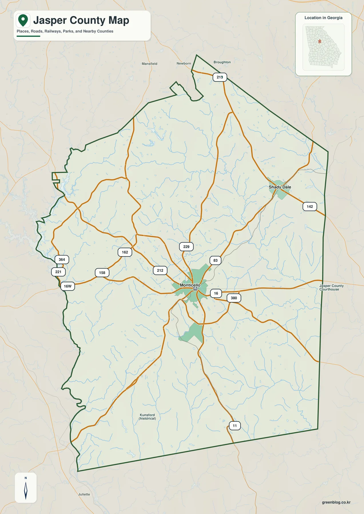
Monticello is the strongest developed place on the general map and serves as the main road reference. Route 16 crosses the city, Route 83 reaches toward the northeast, and Route 229 approaches from the north. Route 212 enters from the northwest. West of Monticello, Routes 162, 158, 221, and 364 cross more lightly developed rural areas, while Route 11 extends south toward the county line. Route 380 provides another reference on the east side of the city. Together, these roads show Monticello as the internal hub without turning the page into a street-navigation map.
Shady Dale appears in the northeastern part of the county and is much smaller on the map. Route 142 crosses the town and continues toward the eastern county side, while the broader road pattern ties it back toward Monticello through the interior. Route 213 is visible farther north near the narrow northern extension of the county. The supplied maps do not provide a measured city-to-city distance, so this article does not invent one. The useful point is their relative position: Monticello is central-southern, while Shady Dale sits closer to the northeastern boundary.
The western boundary is far more irregular than the eastern side. It bends around a river-and-water corridor and contains narrow projections that make the county outline easy to recognize. Mansfield, Newborn, Broughton, and Juliette appear outside the county as surrounding references. A historical Kunsford label is visible in the south, but it is not part of the ranked city view. These outside and historical labels help with orientation without changing the two-city emphasis of the current map package.
Monticello and Shady Dale on the Ranked City View
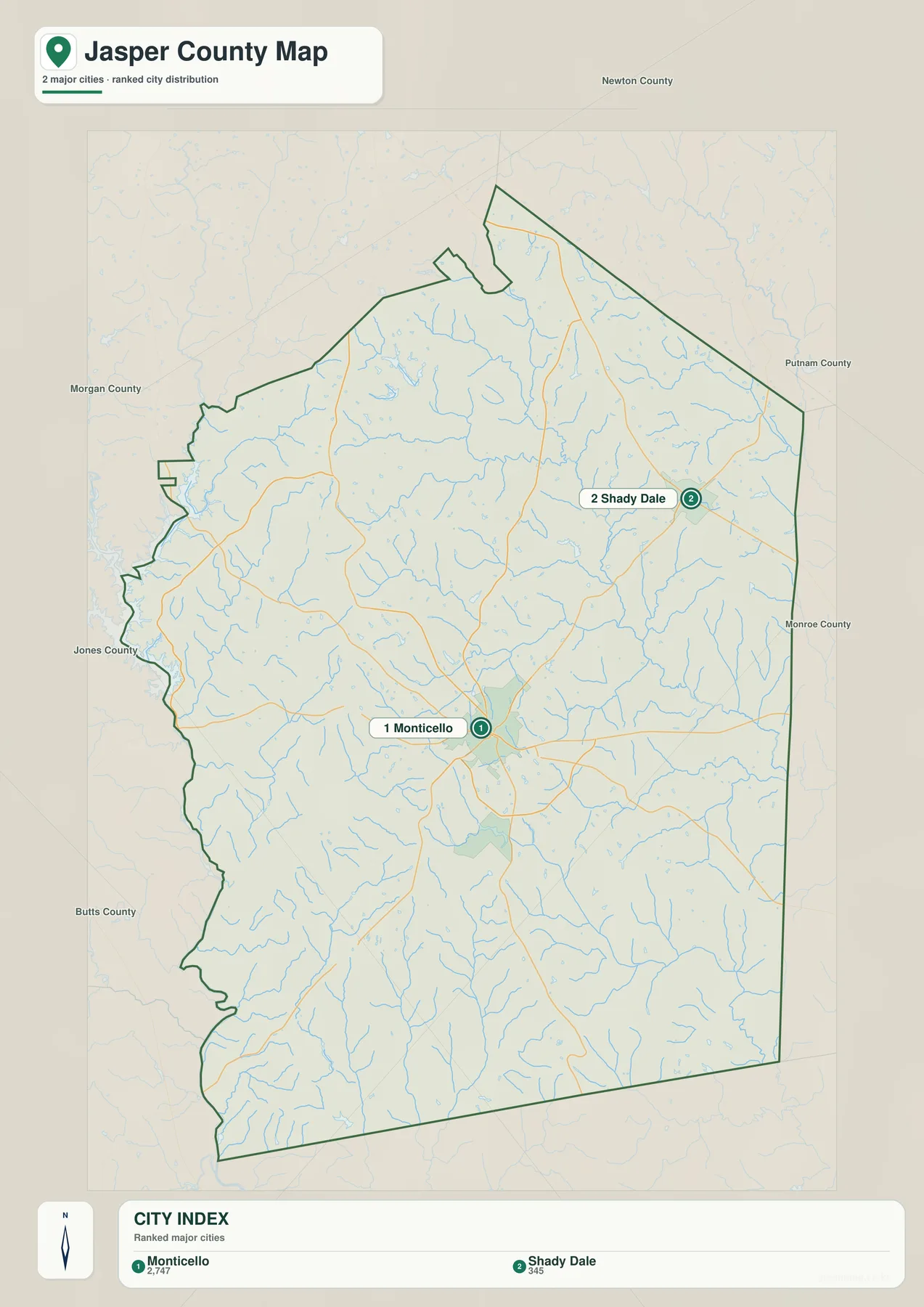
The city map removes most road and landmark detail and ranks two places. Its CITY INDEX lists Monticello at 2,747 and Shady Dale at 345. Those values are reproduced from the supplied graphic to explain the ranking and should not be treated as newly verified population estimates for this article. Readers looking for current official demographic figures can use the U.S. Census Bureau source in the reference section below.
Monticello is both the larger displayed city and the county seat. Shady Dale lies closer to the northeastern edge and occupies a much smaller developed footprint. The large amount of open space between them is important: Jasper County is not visually dominated by a chain of towns. Most of the interior is rural terrain crossed by tributaries and county roads, so the city layer is best understood as a simple location comparison rather than a complete settlement inventory.
Newton County is labeled to the north, Putnam County to the east, Monroe County to the southeast, Butts County to the southwest, Jones County to the west, and Morgan County to the northwest. These labels provide regional orientation rather than survey-grade boundary measurements. They are especially useful on this simplified city map because they show how Monticello sits well inside the county while Shady Dale is much closer to the Putnam and Newton County side.
| Map rank | City | Displayed value | General position |
|---|---|---|---|
| 1 | Monticello | 2,747 | central-southern county seat |
| 2 | Shady Dale | 345 | northeast |
Ocmulgee River Lowlands and Jasper County’s Creek Network
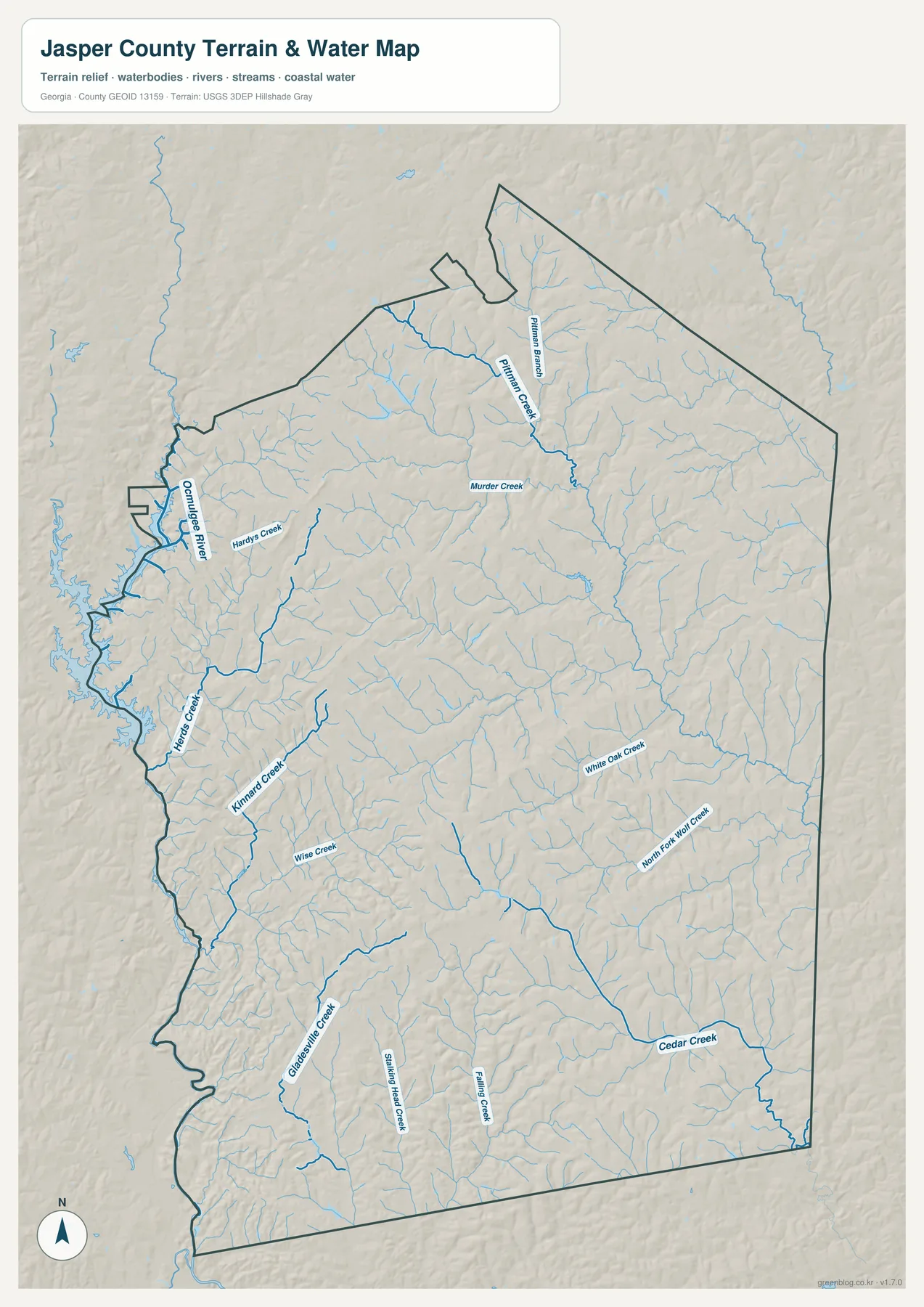
The Ocmulgee River is the clearest large water feature on the western side of the map. It follows the irregular county edge through a broad low corridor, with water and tributary branches creating a much more complex boundary than a straight county line. Hardys Creek approaches that western system through the west-central interior. Farther south, Kinard Creek and Wise Creek form additional named valleys, while Gladesville Creek is labeled in the southwest. These features make the western side easy to recognize even when town labels are absent.
The northern interior contains another dense set of drainage lines. Pittman Creek and Pittman Branch descend from higher ground, and Murder Creek crosses a long central-northern valley. Numerous smaller tributaries are visible around them. The effect is especially clear when the water map is compared with the relief map: the named creeks occupy low cuts between the stronger northern and central ridges rather than running across the highest terrain.
Eastern and southern Jasper County are organized by a different group of channels. White Oak Creek and North Fork Wolf Creek follow long valleys in the east, while Cedar Creek becomes a strong southeastern reference. Shiloh Head Creek and Falling Creek are labeled farther south. The eastern half therefore lacks one single dominant river label; instead, several creek systems divide the rural landscape into parallel and branching low corridors.
The older page material identifies Jackson Lake as part of Jasper County’s local setting. The current water preview, however, directly labels the Ocmulgee River and individual creeks rather than printing Jackson Lake as the main map label, so this rewrite gives priority to the features that are visibly named on the supplied map. The water layer is suitable for county-scale orientation, not for parcel flood status, water depth, shoreline ownership, or legal access. Those questions require the appropriate current local or agency records.
Elevation from About 112 to 254 Meters
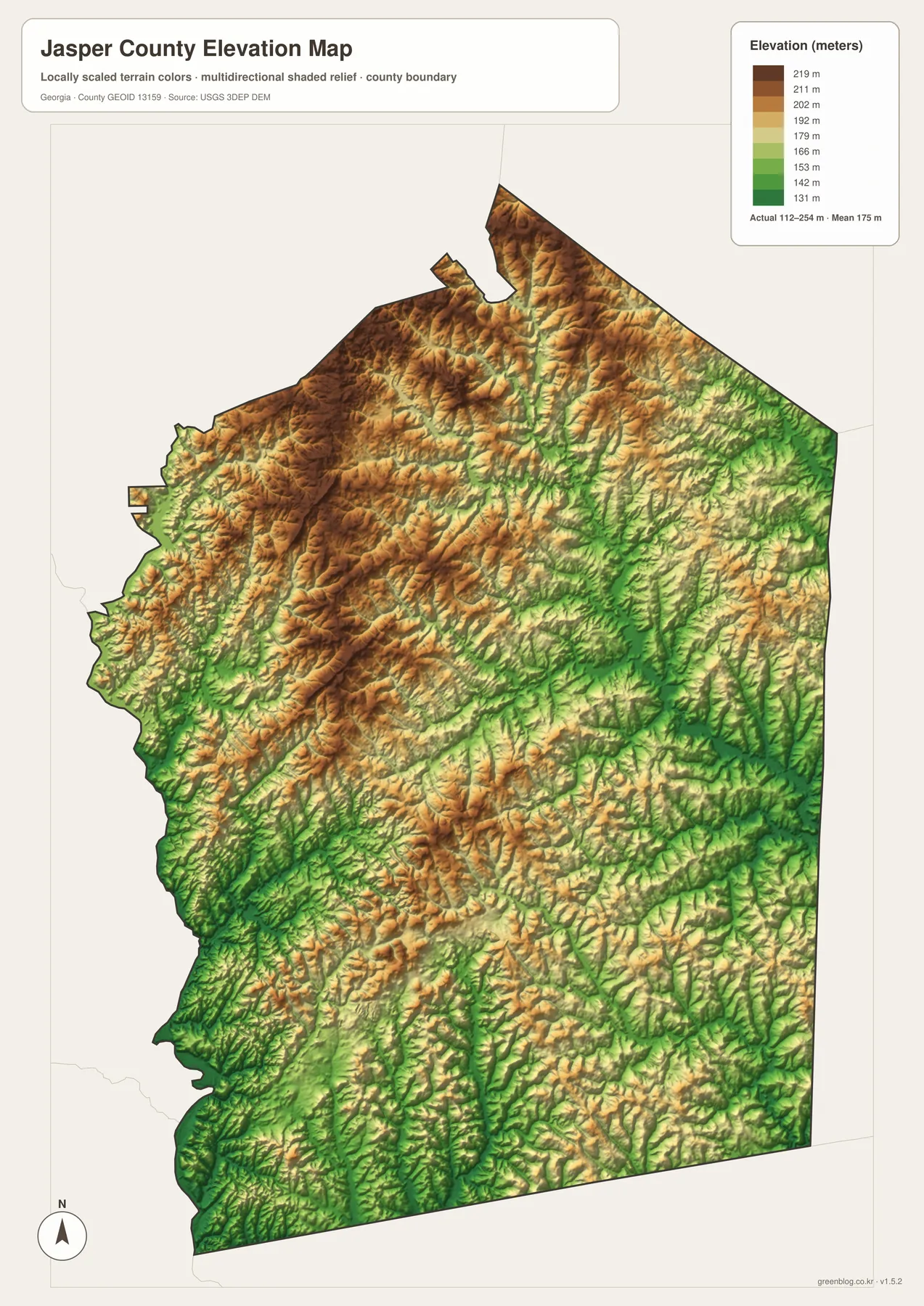
The supplied elevation map reports an actual range of approximately 112 to 254 meters, with a mean of 175 meters. The strongest brown high ground is concentrated across the north, northwest, and parts of the central interior. Green lowlands are more common along the western Ocmulgee River corridor and through many eastern and southeastern stream valleys. The total difference of roughly 140 meters is moderate, but it produces a detailed rolling landscape of short ridges and narrow drainage cuts.
Pittman Creek and Murder Creek provide good examples in the north. Both follow lower green corridors between nearby tan and brown ridges. Hardys Creek and Kinard Creek show a similar relationship farther west as they descend toward the Ocmulgee side. The water map explains the drainage names; the elevation layer explains why those channels occupy particular routes through the landscape.
The eastern county is generally lower than the strongest northwestern uplands, but it is not flat. White Oak Creek and North Fork Wolf Creek run through long green valleys separated by short rolling ridges. Cedar Creek occupies another low corridor in the southeast, and the southern boundary contains many smaller tributary cuts. Jasper County is therefore better described as rolling uplands divided by creek valleys than as either mountain terrain or a broad level plain.
The relief layer is intended for broad comparison across the county. It is not a survey-grade source for a house lot, road design, construction project, or drainage plan. Site-level work requires finer elevation data and any field measurements appropriate to that task. For classroom geography, local research, or presentations, the 112–254 meter range clearly separates the higher northern-central ridges from lower river and creek corridors.
Monticello and a Rural County Shaped by Rivers and Rolling Ground
The source material in the package states that Jasper County was established in 1807 and describes agriculture, forestry, historic townscapes, Jackson Lake, and commuting toward Atlanta and Macon as parts of its local context. The four maps here do not measure farm output, forest acreage, commuting, or historic resources. Instead, they provide the geographic framework beneath those subjects: Monticello at the administrative center, Shady Dale in the northeast, a road network spread across a largely rural county, the Ocmulgee River on the west, and numerous creek valleys crossing rolling uplands.
Monticello is especially useful for connecting the themes. Routes 16, 83, 229, and 212 meet the broader road network around the county seat, while Route 11 continues south. West of the city, the landscape drops toward the Ocmulgee River system; north and northwest, higher ridges become more prominent; eastward, White Oak and Cedar Creek valleys occupy lower ground. Looking at those relationships together gives a more complete picture of Jasper County than a city list or road map alone.
The general map is the best starting point for city names, roads, and the county outline. The ranked city view is cleaner for comparing Monticello and Shady Dale. The water map is more useful for the Ocmulgee River, Hardys, Kinard, Murder, Pittman, White Oak, Cedar, and other creeks, while the elevation map explains the higher uplands between those valleys. Because the four files share the same county boundary, they work well as a set for classroom use, local history projects, reports, and presentations.
Frequently Asked Questions
Which cities are ranked on the city map?
The supplied city view ranks Monticello at 2,747 and Shady Dale at 345. Monticello is also the Jasper County seat, while Shady Dale is the smaller northeastern city on the map.
Which waterways are easiest to identify?
The Ocmulgee River is the strongest western reference. Hardys Creek, Kinard Creek, Wise Creek, Murder Creek, Pittman Creek, White Oak Creek, and Cedar Creek provide additional named valleys across the county.
What elevation range is shown for Jasper County?
For Jasper County, the relief legend spans about 112 to 254 meters, with the mean marked at 175 meters. Higher ground is strongest across parts of the north and central interior, while the Ocmulgee River and many eastern and southern creek valleys are lower.
What does the A3 download package contain?
The archive includes four large JPG originals covering the general county reference, Monticello–Shady Dale city view, waterways, and elevation. The separate files make roads, city labels, creek names, and relief easier to read when printed or placed in a document.
Map File Information
Jasper County A3 Map Files
- Included Files: 4 high-resolution A3 JPG map files shown in this article
- File Type: JPG files in a ZIP archive
- Intended Use: Printing, education, presentations, and map-based projects
Related Maps
Jasper County Data and Map References
- U.S. Census Bureau QuickFacts: Jasper County – current official county statistics
- New Georgia Encyclopedia: Jasper County – county history and the 1807 establishment date
- New Georgia Encyclopedia: Monticello – local background on the county seat
- Census TIGER/Line boundary resources – Jasper County and neighboring-county reference geometry
- USGS hydrography resources – reference data for the Ocmulgee River and named creek systems
- USGS 3DEP elevation resources – source elevation data for comparing the 112–254 meter terrain range
Green Map creates custom-edited map images using open geographic data sources such as geoBoundaries, Natural Earth, OpenStreetMap, and government open data. These maps are edited visual materials, not raw data files, and are provided for education, documents, presentations, and graphic reference.