St. Martin Parish in south-central Louisiana is unusual before you even begin reading the place names: the parish is split into two physically separated sections. The larger northern section contains Breaux Bridge, St. Martinville, Henderson, Parks, Cecilia, and Arnaudville, while a detached southeastern section lies deep in the Atchafalaya Basin and is dominated by waterways rather than towns. This page explains both pieces through the supplied road, city-index, and terrain-and-water maps, and matching high-resolution JPG originals can be downloaded together in a ZIP. High-resolution map files are available for download in the section below.
St. Martinville is the parish seat. Louisiana’s official parish profile lists Breaux Bridge, Broussard, Morgan City, and St. Martinville as cities, Arnaudville and Henderson as towns, and Parks as a village. On the supplied maps, most of the named settlements are concentrated in the northern section. The detached southeastern section has a very different character: LA 70 and a dense network of Atchafalaya Basin waterways matter more than any major urban center. Understanding that split is the key to reading the parish correctly.
Table of Contents
Why St. Martin Parish appears as two separate pieces
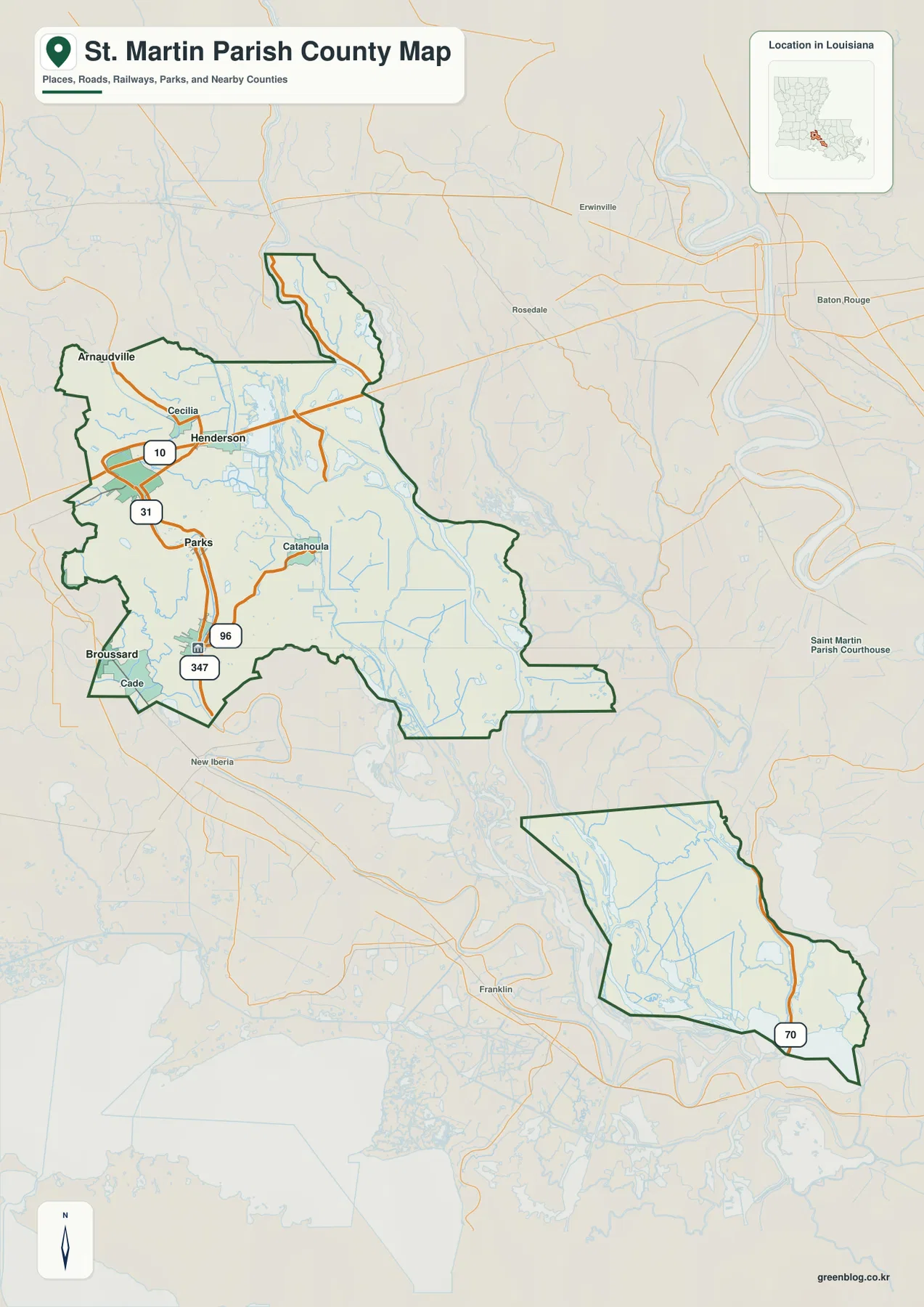
The general map clearly shows a large northern body and a smaller southeastern section with no shared land boundary between them. This is the actual parish geography, not a cartographic shortcut. Louisiana parish-history sources trace the fragmented shape to the creation of Iberia Parish in 1868 from land that had belonged to St. Martin and neighboring parishes. Iberia Parish now occupies the land between the two St. Martin sections.
That fact changes how the map should be read. Following the boundary south from St. Martinville does not lead directly into the detached lower section because another parish lies between them. The southern piece therefore appears like a separate island of parish territory. The city-index map reinforces this difference: all four ranked settlements are in the northern section, while the lower section is almost entirely explained by roads, basin water, and wetlands.
I-10 ties Breaux Bridge and Henderson to the northern transportation corridor
I-10 is the clearest east-west road across the northern part of St. Martin Parish. It enters from the Lafayette side, passes the Breaux Bridge area, and continues toward Henderson before crossing the Atchafalaya Basin toward Baton Rouge. Breaux Bridge is the strongest urban label in the northwest, while Henderson sits farther east where the road network begins to give way to more water and wetland features.
South of Breaux Bridge, LA 31 and LA 347 help organize the corridor through Cecilia and Parks. Arnaudville lies near the northwestern edge, while local routes connect the smaller communities between the interstate and St. Martinville. The settlement pattern therefore has two dimensions: an I-10 band running east-west and a Bayou Teche-side corridor extending south toward the parish seat.
St. Martinville, Parks, and Catahoula mark the transition from towns to basin lowlands
Moving south from Breaux Bridge, Parks appears before St. Martinville, the parish seat. LA 31 and LA 96 provide useful references through this part of the map, while St. Martinville sits near several branching local roads. Cade and Broussard appear near the southwestern edge, and Catahoula lies farther east where the road network meets a much wetter landscape.
The change around Catahoula is visually important. West of the basin edge, named communities and road lines remain prominent; farther east, winding channels and wetland water features occupy far more of the map. This contrast makes the northern section itself feel like two different environments—one centered on the Bayou Teche communities and another opening into the Atchafalaya lowlands.
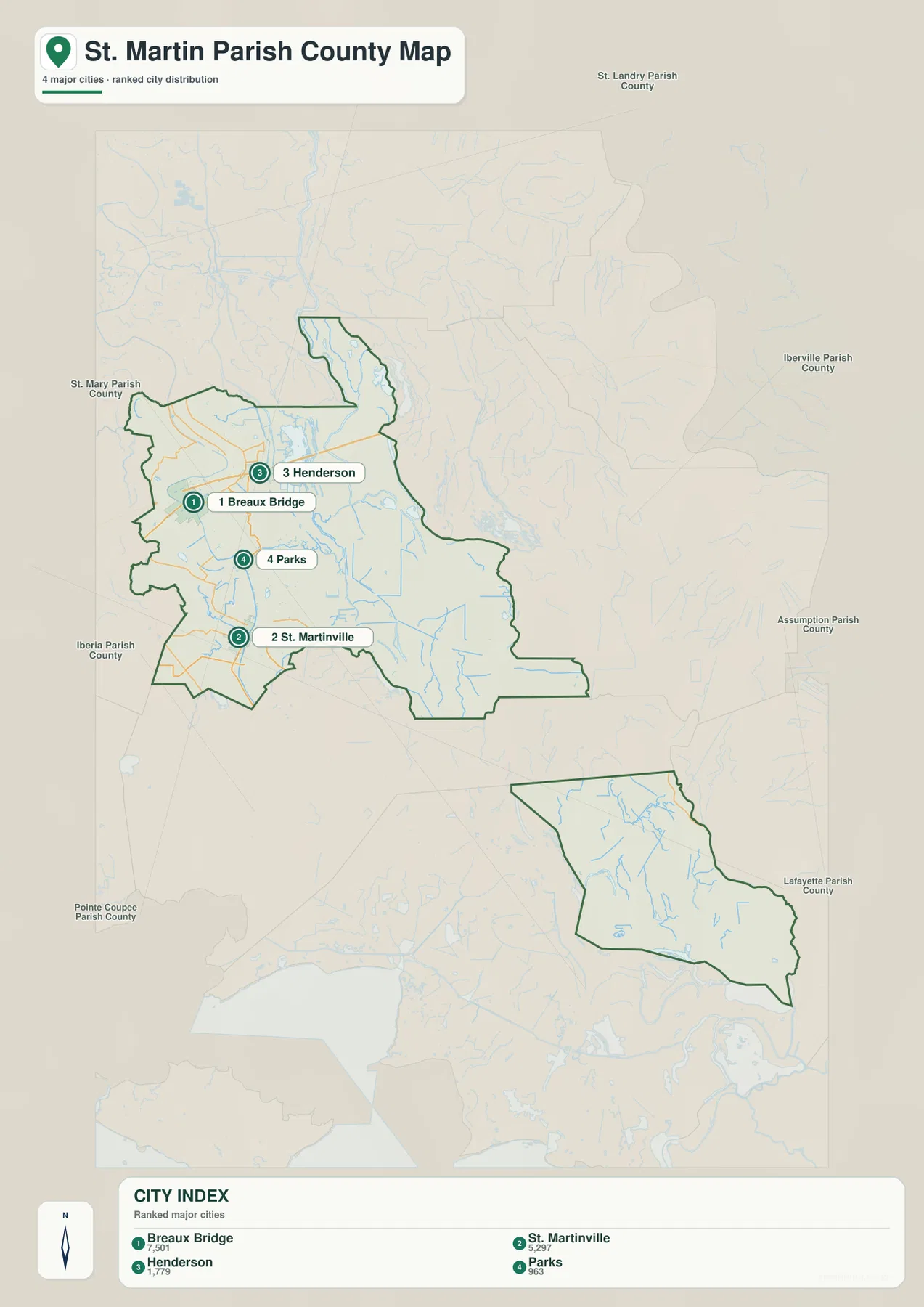
The ranked city index compares Breaux Bridge, St. Martinville, Henderson, and Parks
The city-index graphic ranks four selected communities: Breaux Bridge is number 1, St. Martinville 2, Henderson 3, and Parks 4. These numbers are rankings, not straight-line or driving distances. Breaux Bridge and Henderson occupy the upper I-10 area, while St. Martinville and Parks lie farther south in the northern section.
Arnaudville, Cecilia, Catahoula, and Broussard remain visible on the detailed parish map but are not part of the four-place ranking. No ranked city appears in the detached southeastern section. The index is therefore best used as a simplified view of the principal northern settlements rather than as a complete list of every community in St. Martin Parish.
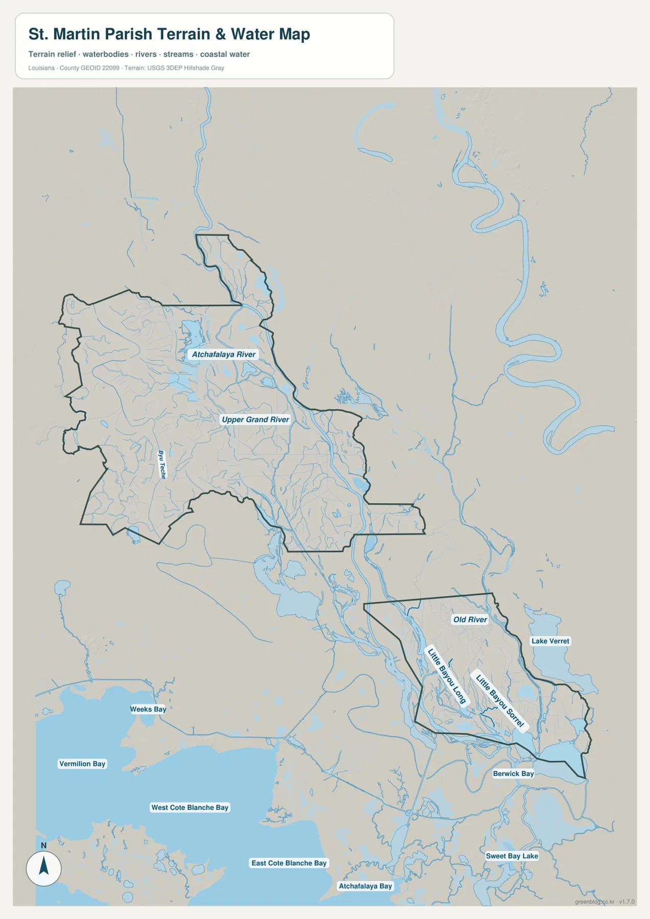
The Atchafalaya River and Upper Grand River define the wet eastern side of the northern section
The terrain-and-water map shifts attention away from roads and toward the Atchafalaya Basin. The Atchafalaya River is one of the largest named channels on the eastern side of the northern section, with the Upper Grand River running through the interior lowlands. Together they explain why the eastern half of the parish has far fewer dense settlement labels than the Breaux Bridge–St. Martinville side.
Bayou Teche provides a different water reference through the populated western side. Many of the older communities lie along or near this corridor, so roads and settlement names tend to follow the same broad north-south direction. Moving east from Bayou Teche toward the Atchafalaya River, the map becomes increasingly dominated by channels, backwaters, and basin wetlands instead of streets.
Old River, Little Bayou Long, and Little Bayou Sorrel dominate the detached lower section
The southeastern section looks almost like a different parish map. Old River is labeled along its northern side, while Little Bayou Long and Little Bayou Sorrel run through the interior. LA 70 is the most obvious road reference, and much of the remaining area is filled with wetland channels and open water rather than towns. This is why the lower section contributes little to the ranked city map but becomes one of the most distinctive parts of the water map.
Berwick Bay appears at the southern edge, and Lake Verret is visible beyond the eastern boundary. Atchafalaya Bay and Vermilion Bay provide wider regional context farther south and west. These labels are useful for orientation, but the map is not a flood, boating, parcel, or navigation product. Water depth, flood stage, levee status, navigability, and legal boundaries require current specialized sources.
Reading the two sections separately makes the parish much easier to understand
A practical first pass is to ignore the lower section temporarily and orient the northern body around Breaux Bridge, Henderson, Parks, and St. Martinville. I-10 establishes the east-west direction, while LA 31 and the Bayou Teche corridor help with the north-south relationship. Catahoula then marks the transition into the wetter eastern interior.
After that, treat the detached southeastern section as its own map window and use LA 70, Old River, and the two Little Bayou channels as references. The two pieces are separated on land but both belong to the wider Atchafalaya landscape. The Atchafalaya National Heritage Area describes the basin as the nation’s largest river swamp, and the supplied water map makes St. Martin Parish’s close connection to that environment immediately visible.
High-resolution JPG files preserve the unusual boundary and fine water detail
The downloadable ZIP contains the original JPG files corresponding to the three previews on this page: the general parish map, the ranked city map, and the terrain-and-water map. Each original image is 2572 by 3638 pixels, providing more room to inspect route numbers, settlement names, bayou labels, and the separation between the two parish sections than the web preview. The files are useful for printing, classroom material, presentation slides, and personal geographic reference.
Choose the general map when Breaux Bridge, St. Martinville, roads, and the split boundary need to appear together. Use the city index for the four ranked northern communities. The water map is the better choice for the Atchafalaya River, Upper Grand River, Old River, Little Bayou Long, Little Bayou Sorrel, and the surrounding basin waterways. These are general reference maps rather than legal boundary, survey, flood-risk, or real-time navigation products.
Frequently Asked Questions
Why is St. Martin Parish split into two separate sections?
The parish is genuinely noncontiguous. When Iberia Parish was created in 1868, land that became Iberia separated the northern and southeastern parts of St. Martin Parish. The detached lower boundary on the map is therefore still part of the same parish.
What is the parish seat of St. Martin Parish?
St. Martinville is the parish seat. On the general map it lies in the southern part of the larger northern section near the LA 31 and LA 96 corridor. Breaux Bridge is farther north, while Henderson lies east along the I-10 side of the parish.
Can the Atchafalaya Basin water map be used for flood or boating decisions?
No. The map is a general geographic reference showing the Atchafalaya River, Upper Grand River, Old River, Little Bayou Long, and other waterways. It does not provide flood stage, water depth, navigation clearance, levee status, or legal property boundaries. Those decisions require current specialized information.
Map File Information
The ZIP contains the original high-resolution JPG files corresponding to the general parish map, ranked city map, and terrain-and-water map shown on this page.
- Included Files: parish map JPG, ranked city map JPG, terrain-and-water map JPG
Related Maps
Sources and references
For parish-seat and municipality information, see the Louisiana.gov St. Martin Parish Profile. The fragmented parish shape is discussed by 64 Parishes, and the broader basin setting is described by the Atchafalaya National Heritage Area. General boundary data are documented by the U.S. Census Bureau TIGER/Line Shapefiles, and national water-feature data are documented through USGS National Hydrography.
Green Map creates custom-edited map images using open geographic data sources such as geoBoundaries, Natural Earth, OpenStreetMap, and government open data. These maps are edited visual materials, not raw data files, and are provided for education, documents, presentations, and graphic reference.