Baxter County sits in north-central Arkansas, where Mountain Home anchors the road network and long Ozark ridges are cut by rivers, creeks, and the branching shoreline of Norfork Lake. The page combines county, city, water, and elevation views so you can compare roads and communities with the valleys around the North Fork River and the higher ground between them. You can also download the matching high-resolution JPG map files together in one ZIP package for printing, presentations, classroom material, or other document work.
The county government describes Baxter County as a rugged, mountainous part of north-central Arkansas and identifies Mountain Home as the county seat. That description fits the supplied maps well. Mountain Home occupies a relatively central position on rolling uplands, Norfork Lake cuts into the northeast with many narrow arms, and the North Fork River continues south through a visibly lower valley. The western side around Cotter and Buffalo City is also shaped by a large river corridor. Reading those features together gives a clearer picture of the county than a simple list of town names or highway numbers.
Table of Contents
Mountain Home anchors the main east-west and north-south routes
Mountain Home is the easiest place to begin on the county map because several of the most visible routes meet in or near the city. The east-west corridor is marked 412 west of Gassville and 62 east of Mountain Home, creating a clear line across the central part of the county. Route 201 runs north from Mountain Home and continues south as well, while 126 and 178 serve the western side and 101, 342, and 177 help define routes toward the east and southeast. The map is not a turn-by-turn driving product, but these numbered roads provide a useful framework for explaining where the county’s communities sit in relation to one another.
West of Mountain Home, Gassville and Cotter form a close pair, with Lakeview farther northwest and Midway between the lake area and the county’s central hub. Henderson lies east of Mountain Home near the western reaches of Norfork Lake, while Gamaliel appears farther north. To the southeast, Briarcliff, Salesville, and Norfork occupy a separate cluster near the North Fork River. Big Flat is much farther south in the long lower extension of the county. This irregular shape matters: Baxter County is easier to understand as several connected road-and-valley areas than as a simple rectangle with towns evenly spaced inside it.
The neighboring-county labels on the city map also help with orientation. Marion County is on the west, Stone and Searcy counties are to the southwest, and Izard and Fulton counties lie to the east. The northern edge reaches the Arkansas-Missouri state line. Along the west, the boundary bends repeatedly near large river and reservoir terrain rather than following one long straight line. These outlines are useful for county-scale reference, but they should not be treated as parcel boundaries or a legal survey.
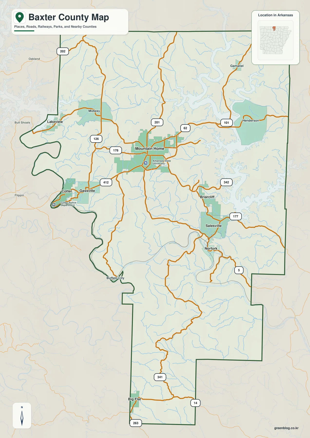
For general location work, the road map is most useful when it is read by direction rather than as a driving schedule. Mountain Home to Gassville and Cotter gives a clear westward reference, Mountain Home to Henderson establishes the eastern side, and the roads toward Salesville and Norfork show how the southeast connects back to the center. Route 341 and Route 14 help identify the far southern section around Big Flat. Current road closures, construction, travel times, and navigation should still be checked with an up-to-date transportation service.
A large central city and smaller towns along the river valleys
The city index map ranks six places: Mountain Home, Gassville, Cotter, Lakeview, Norfork, and Salesville. The reference values printed on the supplied map are 13,108 for Mountain Home, 1,850 for Gassville, 1,063 for Cotter, 851 for Lakeview, 690 for Norfork, and 515 for Salesville. Those figures should be read as the values built into this map rather than as a claim about a live population count. Their main purpose here is to show the relative size and location of the county’s principal incorporated communities.
Mountain Home clearly stands apart as the dominant center, but the smaller towns are not arranged in a simple ring around it. Gassville and Cotter sit together to the west near the large river valley. Lakeview is farther northwest in the lake-and-river landscape, while Norfork and Salesville form a southeastern pair around the North Fork River system. That distribution gives Baxter County more than one local reference area: Mountain Home is the road and service center, but the western and southeastern communities are closely tied to separate river corridors.
Several places that are not part of the six-city ranking still add useful detail on the main map. Midway lies northwest of Mountain Home, Henderson sits close to Norfork Lake, Briarcliff is north of Salesville, Buffalo City appears near the winding western boundary, and Big Flat occupies the far southern extension. Gamaliel marks the northeastern part of the county. Including these smaller labels is helpful for local orientation because a user looking for a lake access area, rural road, or neighboring community may need more than the largest city names.
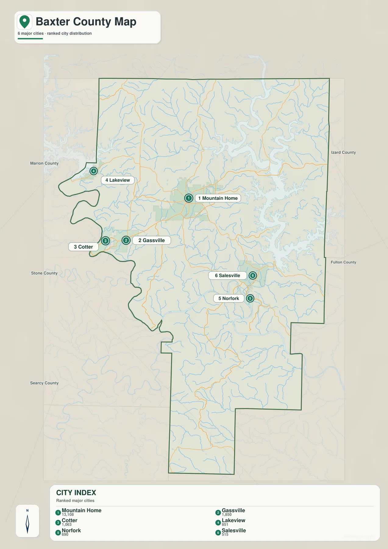
The city map becomes more informative when it is compared with the terrain maps. Cotter and Gassville are west of Mountain Home near a deeply cut river corridor, while Norfork and Salesville lie where the North Fork River and several tributaries cross the southeastern hills. Lakeview is associated with the northwestern water landscape rather than the county’s interior road grid. Mountain Home, by contrast, sits away from the largest water bodies on rolling ground where several routes can approach from different directions. Those differences are easy to miss on a population list but obvious once the four maps are read together.
Norfork Lake opens into a network of river and creek valleys
Norfork Lake is the dominant water feature on the terrain-and-water map. Its many narrow arms reach into the northeastern hills, producing a highly indented shoreline rather than one smooth open basin. South of the lake, the North Fork River continues toward Norfork through a clearly defined valley. Bennetts River is labeled in the northeast, and Pigeon Creek enters the northern part of the mapped drainage network. The lake is especially useful as an orientation feature because Henderson lies near its western side and the surrounding low valleys stand out again on the elevation map.
A number of named creeks break up the interior hills. Hightower Creek lies in the west, Ricks Creek and Big Creek cross the central section, and Dry Creek and Barren Creek appear farther west. Moffit Creek runs southward near the North Fork River, with Otter Creek to the east. In the southern half, Walker Creek, Sneed Creek, and Mill Creek follow narrow low areas between higher ridges. These are not just extra labels. Together they show why the county’s relief looks so dissected: short stream valleys repeatedly cut into the uplands.
The western side has a different large-water shape. Near Cotter and Buffalo City, a major river valley follows a series of broad bends along and near the county boundary. Baxter County’s official site discusses the White River and Bull Shoals Dam in the western part of the county as well as Norfork Dam on the North Fork River. The supplied map is not intended to document dam operations, but it does show the contrast between the broad western river corridor and the branching Norfork Lake-North Fork system to the east and southeast.
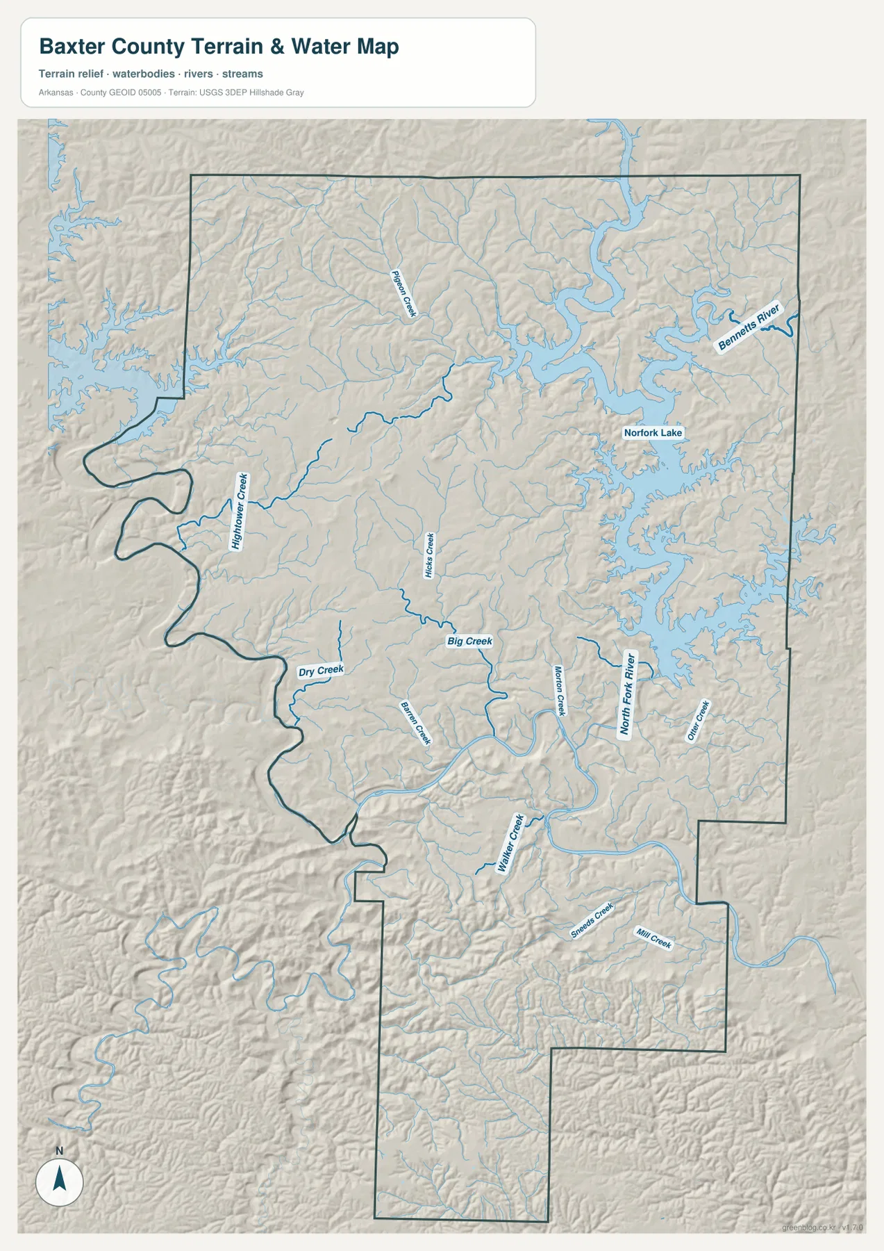
This water map is a general geographic reference, not a flood-risk, navigation, shoreline-title, or engineering map. It does not provide current water levels, safe boating depths, flood zones, dam-release schedules, or legal waterside property boundaries. Those questions require current information from agencies such as the U.S. Army Corps of Engineers, USGS, FEMA, or the relevant local authority. For ordinary map use, however, it is well suited to showing where the lake, river, and creek corridors sit relative to towns and roads.
Elevation falls into the river corridors and rises sharply on the ridges
The elevation map gives an actual mapped range of about 101 to 428 meters and a mean of about 230 meters. Its colors are scaled to Baxter County, so brown and tan identify the higher parts of this county while green marks lower valleys and water-adjacent terrain. High ridges are especially prominent in the northwest and throughout the long southern extension. By contrast, the Norfork Lake shoreline and the North Fork River valley form broad green areas in the northeast and southeast, making the connection between low terrain and major water features immediately visible.
Mountain Home lies on moderate rolling ground rather than at either extreme of the county’s elevation range. Moving east toward Norfork Lake, the terrain becomes more sharply divided by narrow valleys, and the low green areas become larger around the lake arms. South toward Norfork and Salesville, the North Fork River occupies a distinct low corridor with higher hills on both sides. A similar contrast appears around the western river valley near Cotter. That repeated pattern of ridge, creek valley, ridge, and larger river valley is one of the clearest visual signatures of Baxter County on the supplied maps.
The far southern section around Big Flat is particularly rugged on the elevation image. Brown ridge tops are closely spaced, with narrow green drainage lines between them. The northwest also contains broad higher ground, but the central area mixes moderate uplands with many smaller incised valleys. This is why a single statement such as “the north is high and the south is low” would be misleading. The county does not slope evenly in one direction; it is a hill-and-valley landscape in which the lowest areas follow rivers, lake arms, and tributaries.
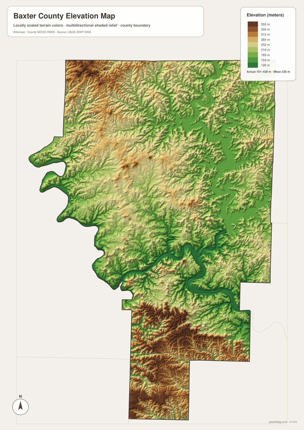
The elevation image is meant for county-scale comparison, not site surveying. A color patch cannot substitute for the exact elevation of a road grade, building pad, parcel corner, drainage structure, or construction site. Engineering, surveying, and design work should use the underlying USGS elevation data or a professional survey. For classroom and general-reference use, the map is useful because it makes the county’s broad relief differences visible without requiring the reader to interpret dense contour lines.
Trace Mountain Home, Norfork, and Cotter across the map set
A practical way to read the map set is to choose one town and follow it from map to map. Start with Mountain Home. The county map establishes its central location and the 62/412 and 201 road connections. The city index shows how much larger it is than the other ranked communities. The water map shows that the city is surrounded by small drainage lines but is set back from the largest lake and river corridors. Finally, the elevation map places it on moderate uplands between the deep eastern and western valleys and the higher ridges farther north and south.
Norfork produces a different sequence. On the road map it appears southeast of Mountain Home near Salesville. On the city map it is one of the smaller ranked towns. The terrain-and-water map then shows the North Fork River passing directly through the area, while the elevation image traces the same river as a long, low green valley. That combination makes Norfork a strong example of how settlement, water, and relief are connected in Baxter County.
Cotter works in much the same way on the western side. It is close to Gassville on the city map, but its setting becomes more distinctive on the water and elevation images, where a large winding river valley cuts through the surrounding hills. Lakeview is useful for understanding the northwestern lake-and-river landscape, and Salesville helps orient the southeastern transition from interior roads toward the North Fork River system. Looking at a familiar place across all four maps is often easier than trying to absorb every label at once.
Each map therefore has a different best use. The county map is the strongest all-purpose choice for roads, towns, and boundaries. The city index is cleaner when the goal is to compare the principal communities without as many labels. The terrain-and-water map is the best fit for Norfork Lake, rivers, and creek-cut valleys, while the elevation map is the clearest way to explain where the lower corridors and higher ridges occur. Selecting the map that matches the question keeps a report, lesson, or presentation easier to read.
Choosing the high-resolution JPG that fits your project
The WebP images on the page are sized for quick viewing, while the downloadable ZIP contains the corresponding 2572 × 3638 pixel JPG originals. The larger files keep small road numbers, creek labels, town names, and elevation shading clearer than a screenshot. A countywide overview is best served by the main map, whereas a document focused on the six highlighted communities can use the city index without extra terrain detail. When Norfork Lake, the North Fork River, or the smaller creeks are central to the topic, the water-and-terrain image gives them more room; the elevation image is most useful when the contrast between low valleys and surrounding ridges needs to be shown.
The portrait orientation is worth preserving when the map is placed in a document because Baxter County extends a long way south toward Big Flat. Heavy horizontal cropping can remove the southern section and give an incomplete impression of the county. If only one image can be used, the county map contains the widest mix of practical information. If the topic is physical geography, pairing the water and elevation maps usually tells the story more clearly because the same lake and river valleys can be compared directly.
Frequently Asked Questions
Why is Mountain Home the easiest starting point on a Baxter County map?
Mountain Home is the most prominent city on the supplied city index and sits near the center of the county’s main road network. From there, it is easy to orient west toward Gassville and Cotter, northwest toward Lakeview, east toward Henderson, and southeast toward Salesville and Norfork.
How are Norfork Lake and the North Fork River connected on these maps?
Norfork Lake fills the northeastern part of the terrain-and-water map with many branching coves. The North Fork River continues south from the lake toward Norfork. On the elevation map, both the lake arms and the river occupy lower green terrain surrounded by higher ridges.
Can the 101–428 meter elevation range be used as a survey value for a property?
No. That range describes the elevations represented across the county-scale map, not the surveyed height of a particular parcel, road, or building site. Precise design or legal work should use the underlying USGS data or a professional survey.
Map File Information
High-resolution JPG files for the Baxter County boundary, city, water, and elevation maps are packaged together.
- Included Files: County map, city map, water map, elevation map
- Printable Size: 2572 × 3638 px each
- File Type: JPG
Related Maps
Sources and References
The county orientation and local water-resource background were checked against Baxter County Government and the U.S. Army Corps of Engineers’ Norfork Lake information. Boundary, hydrography, and elevation references are also linked below so readers can continue to the underlying public-data programs when they need more detail.
- Baxter County Government – county location, Mountain Home, roads, and local water-resource background
- U.S. Army Corps of Engineers – Norfork Lake – official information about Norfork Lake and the North Fork River setting
- U.S. Census Bureau TIGER/Line Shapefiles – county boundary and geographic reference data
- USGS National Hydrography – rivers, streams, and water-feature reference data
- USGS 3D Elevation Program – elevation-data reference
Green Map graphics are edited general-reference maps based on public geographic data. They are suitable for orientation, education, documents, presentations, and printing, but they do not replace official sources for legal boundaries, flood determinations, navigation, land surveying, construction, or engineering design.
Green Map creates custom-edited map images using open geographic data sources such as geoBoundaries, Natural Earth, OpenStreetMap, and government open data.
These maps are edited visual materials, not raw data files, and are provided for education, documents, presentations, and graphic reference.