Ashley County lies in southeastern Arkansas, where the road network around Crossett and Hamburg meets a landscape filled with creeks, bayous, lakes, and low plains. The county overview makes U.S. 82 and U.S. 425 useful anchors for orientation, while the separate water and elevation maps show why the eastern and western sides do not look the same. The maps on this page can be viewed directly in the article, and the matching high-resolution JPG files are available together in a ZIP for printing, reports, presentations, and other offline use.
Trusted Arkansas reference material places the county across two broad landscapes: the Mississippi Alluvial Plain in the east and the West Gulf Coastal Plain farther west. That distinction is visible in the supplied graphics. The elevation image shows higher, more textured ground across much of the north-central interior, while lower colors spread along the western edge and across the eastern lowlands. The terrain-and-water image adds Bayou Bartholomew, named creeks, lakes, and ponds, making it much easier to connect settlement and road locations with the natural setting.
Table of Contents
U.S. 82 links Crossett and Hamburg across the county
The clearest east-west route on the county overview is U.S. 82. It runs through the Crossett area and continues toward Hamburg, providing an easy visual line across the western and central portions of the county. U.S. 425 becomes the stronger north-south reference around Hamburg and continues toward the southern boundary. Smaller state routes branch away from those main roads toward Fountain Hill in the north, Portland and Montrose in the east, and Wilmot in the southeast. The result is not a single urban corridor but a road network serving communities spread across a large rural county.
Hamburg, the county seat, sits slightly north of the visual center of the map. Roads approach it from Crossett to the west, from the Fountain Hill side to the north, from Portland to the east, and from the U.S. 425 corridor to the south. That makes Hamburg especially useful as an orientation point even though Crossett is the larger city on the supplied city-index graphic. Crossett, North Crossett, and West Crossett form the most obvious cluster in the west, while Portland, Montrose, and Wilmot are separated by much more open space on the eastern side.
The county boundary also carries useful geographic information. The north edge is comparatively straight, while the western side is much more irregular. The southern boundary meets Louisiana, placing Ashley County at the bottom of Arkansas rather than in the interior of the state. The city-index map labels Drew County to the north, Chicot County to the east, and Bradley and Union counties to the west. Those surrounding names help a reader understand where the county sits before focusing on individual roads or towns.
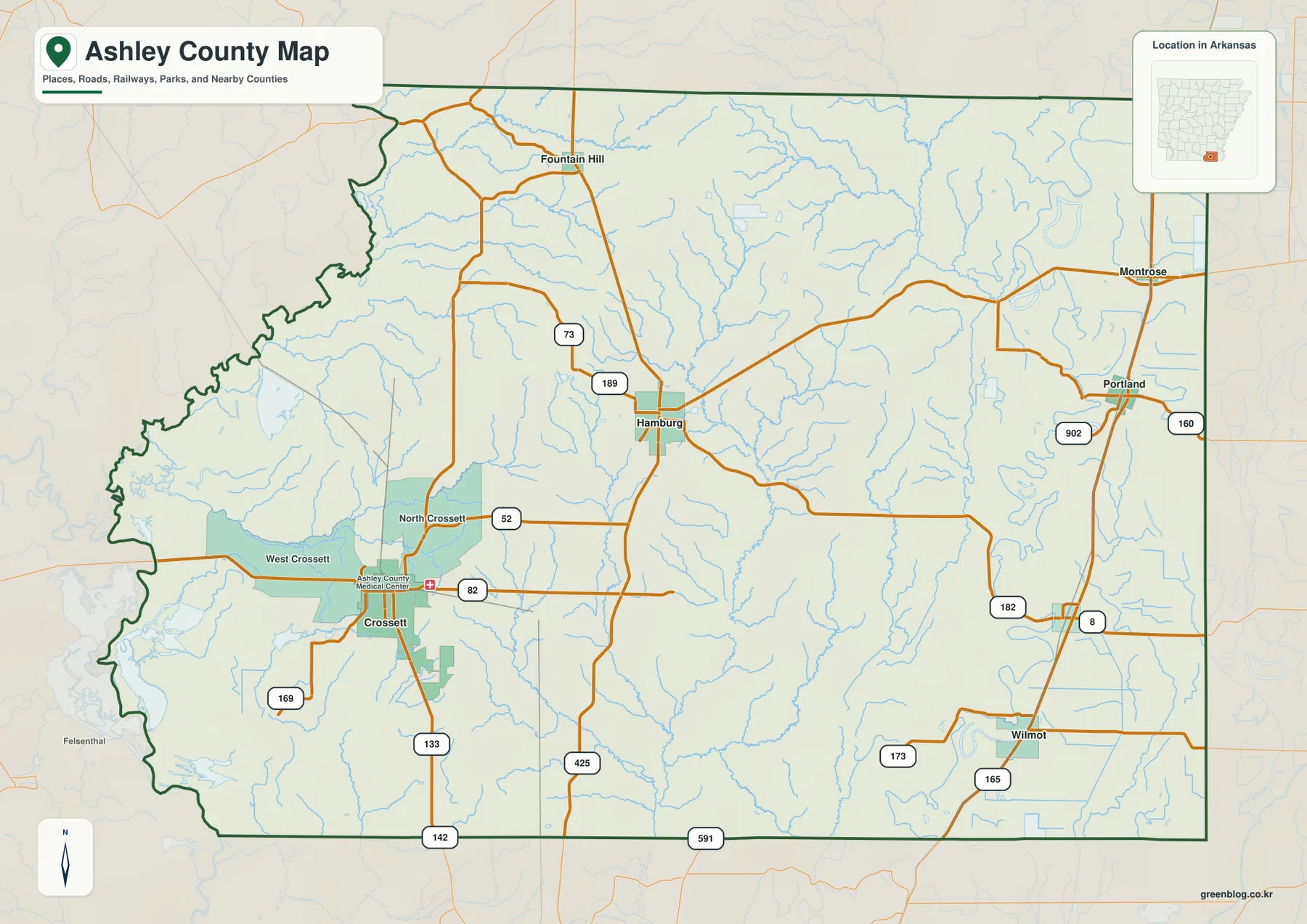
This overview is best used for county-scale orientation rather than turn-by-turn navigation. Routes such as U.S. 82, U.S. 425, Arkansas 133, 165, 52, 173, and 182 show the broad connections between communities, but the image is not intended to report closures, construction, speed limits, or current travel times. It is especially useful when matching the same places across the water and elevation maps: once Crossett, Hamburg, Portland, and Wilmot are located here, the natural features on the other images are much easier to place.
Six city markers reveal a split between western and eastern centers
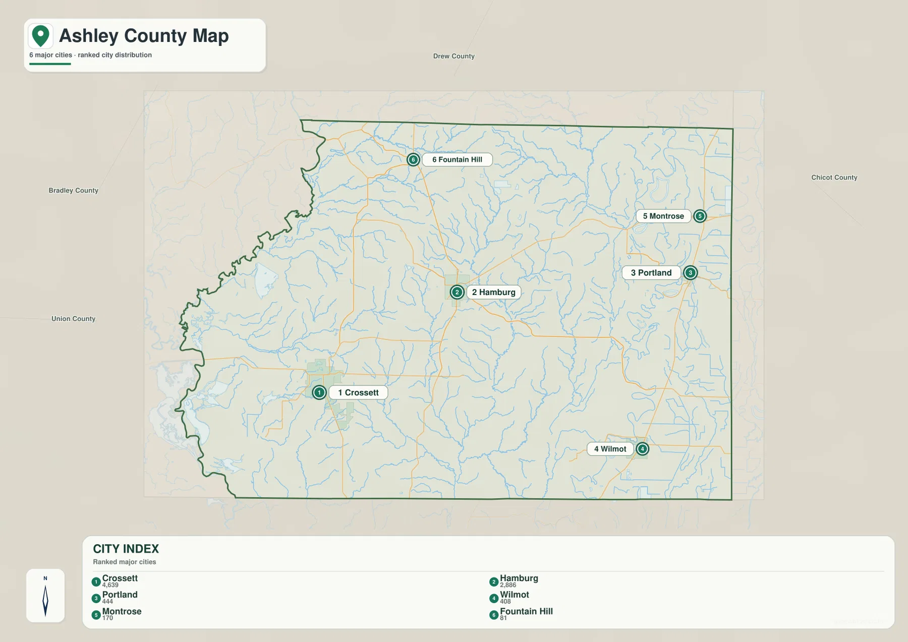
The city-index map labels six communities: Crossett, Hamburg, Portland, Wilmot, Montrose, and Fountain Hill. The reference values printed on the supplied map are 4,639 for Crossett, 2,886 for Hamburg, 444 for Portland, 408 for Wilmot, 170 for Montrose, and 81 for Fountain Hill. These numbers should be treated as values embedded in this particular graphic, not as live population estimates. Their purpose on this page is to show relative ranking and the geographic spread of the labeled places.
Crossett ranks first and sits well to the west, while Hamburg ranks second near the middle of the county. Portland and Montrose form two of the clearest eastern markers, Wilmot is farther south near the southeastern corner, and Fountain Hill is isolated toward the north. Because these places do not form one compact cluster, the map gives a useful picture of a county with several separated local centers. The western concentration around Crossett is visually different from the smaller towns distributed across the eastern half.
Comparing the city-index image with the road map adds another layer. Crossett is tied closely to U.S. 82, Hamburg sits at an important road junction, Portland is reached through the eastern road network, and Wilmot provides a clear reference for the southeastern part of the county. The graphic does not calculate driving distance or travel time, and there are no route connectors that should be read as measured road mileage. It works better as a simple location diagram showing where the six communities sit relative to the county outline.
The contrast between Crossett and the eastern communities also fits the county’s broader geography. The Encyclopedia of Arkansas describes the western side as an upland forest area associated historically with Crossett’s lumber industry, while the eastern Delta section is lower and strongly connected with agriculture. The maps here are not land-use or economic maps, so they should not be used to assign a specific activity to every location. Still, the settlement pattern and elevation image make the west-to-east difference easier to recognize without relying on a long statistical description.
Bayou Bartholomew defines the water-rich eastern side
Bayou Bartholomew is the most prominent named water feature on the eastern side of the terrain-and-water map. It follows a broad, winding north-south course instead of the straight lines seen in the road network. Nearby labels include Horseshoe Lake and Lake Grampus in the northeast and Lake Enterprise farther south. Overflow Creek and Bearhouse Creek run through the eastern interior, while Chemin-a-Haut Creek forms another long drainage feature closer to the middle of the county. Numerous smaller tributaries fill the spaces between these named waterways.
The western half has a different set of references. Lake Georgia Pacific appears near the irregular western boundary, and Big Brushy Creek reaches across part of the west-central area. Cemetery Lake, Mill Pond, and Mossy Lake are also labeled in the southwest. Instead of one dominant bayou controlling the visual pattern, smaller creeks, ponds, and lakes are scattered across several locations. Comparing both sides is more informative than simply counting water bodies because the maps show how the shape and concentration of water features change across the county.
Bayou Bartholomew is especially helpful when matching the water map with the eastern towns. Portland and Montrose sit on the eastern side on the county and city maps, while the water image shows a complex set of winding channels and lakes in the same broad area. Wilmot, farther south, is also close to the Lake Enterprise part of the map. These relationships help explain why the eastern edge looks much less regular than a simple grid of roads and why a water-focused image adds information that the county overview cannot show clearly at the same scale.
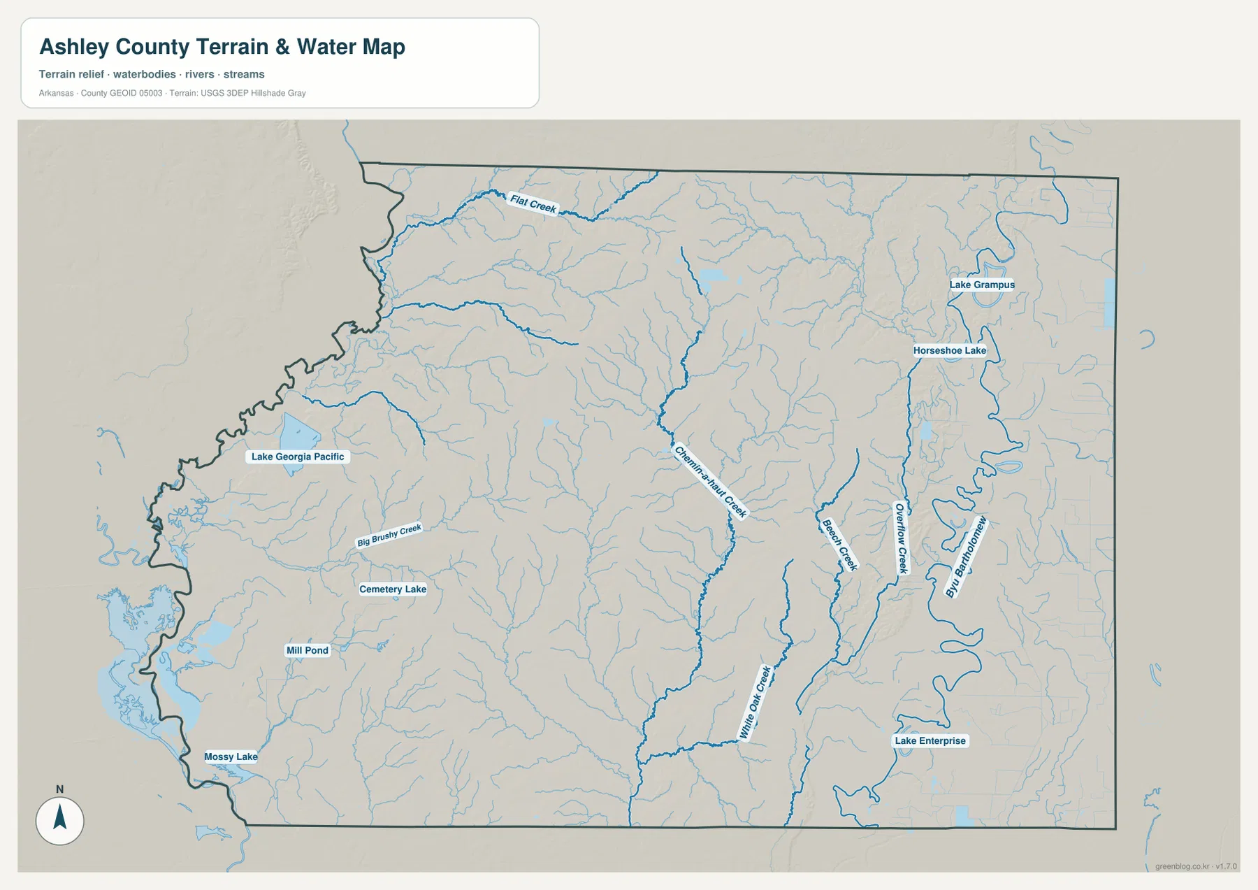
This is a general water-reference map, not a flood, navigation, parcel, levee, or drainage-engineering product. It shows the approximate geographic relationship of streams, lakes, and the county boundary, but it does not provide flood-zone status, channel depth, legal water boundaries, or current conditions. Those questions require the latest information from agencies such as FEMA, USGS, or the appropriate state and local offices. The map is best used for geographic explanation and for comparing water features with roads, towns, and elevation.
Elevation ranges from about 17 to 74 meters across a low-relief landscape
The supplied elevation map reports an actual county range of about 17 to 74 meters and a mean near 41 meters. Ashley County is therefore not a mountain county, but the local differences are still easy to see when the colors are scaled to the county itself. Brown and tan shades cover much of the north-central interior and indicate relatively higher ground. Green shades become broader along the western edge and across the eastern lowlands, showing where the terrain drops within this limited overall range.
The north-central high ground is not a single flat block. Shaded ridges and narrow lower corridors break it into a more textured surface, and some of those lower corridors align broadly with drainage lines visible on the water map. In the east, the large meanders associated with Bayou Bartholomew sit inside a broad low area. The western edge is also low in many places, even though reference material often describes the western part of the county as the more upland side overall. That distinction is useful: broad regional trends do not mean every point within a region has the same elevation.
The color scale should also be read carefully. Because it is adjusted to local relief, the darkest brown areas can look dramatic on the page even though the stated maximum is only about 74 meters. They represent the higher parts of Ashley County, not high mountains. Likewise, the green areas indicate lower ground relative to the county, not necessarily wetlands or flood zones. Water and elevation often relate to one another, but the elevation image alone does not classify soil, land cover, or flood risk.
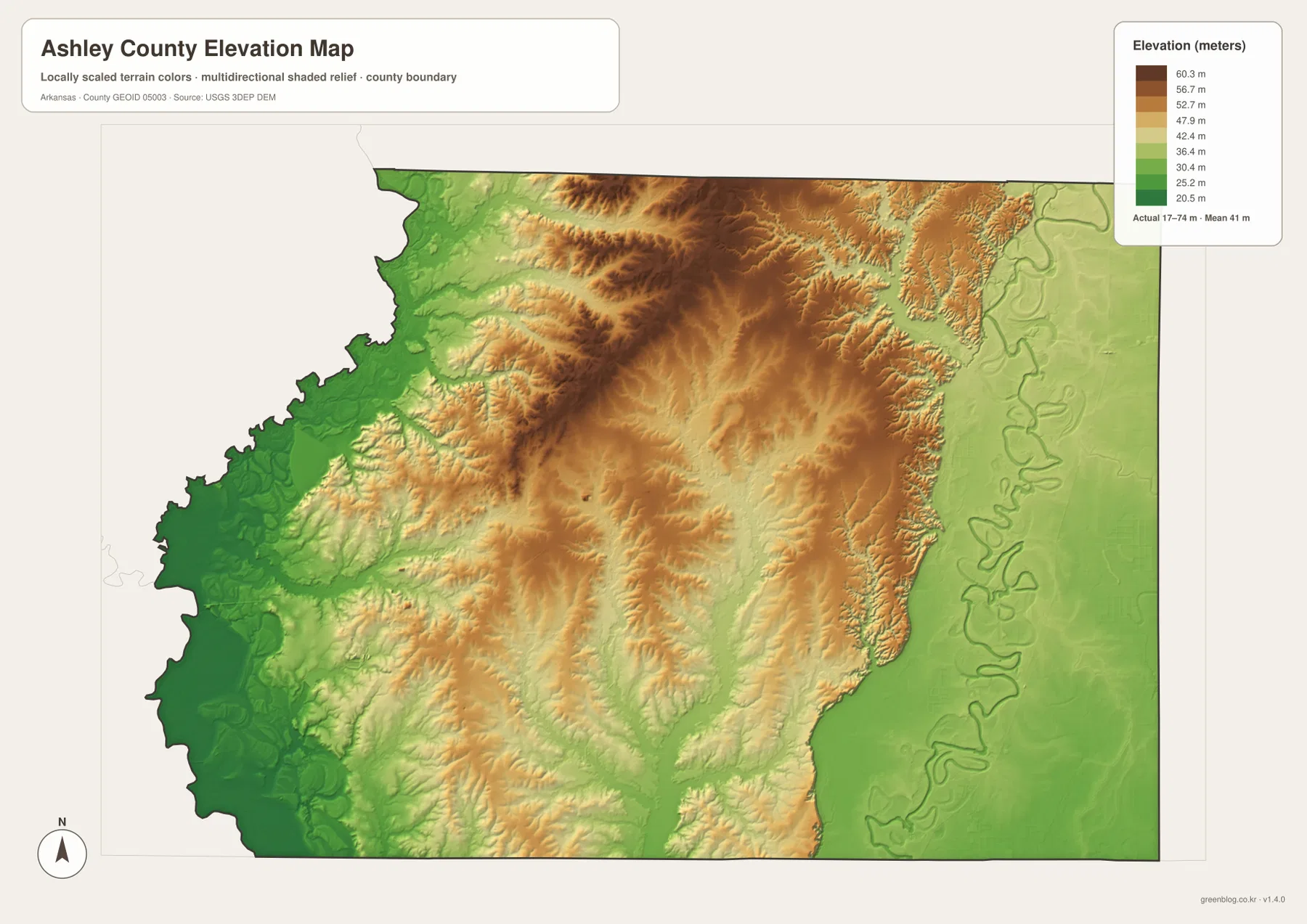
The surface is designed for county-scale comparison and should not be treated as survey-grade measurement. It cannot establish the exact elevation of a farm field, building site, road grade, culvert, or property corner. Construction, drainage design, engineering, and parcel-level work require original elevation data and, when appropriate, professional surveying. For ordinary geographic reading, however, the image clearly shows the relative contrast between higher interior ground and lower areas along the water-rich edges.
What becomes clearer when roads, towns, water, and relief are compared
The easiest way to use the set is to follow the same places from one image to the next. Start with Crossett and Hamburg on the road map and use U.S. 82 as an east-west anchor. Add Portland, Montrose, Wilmot, and Fountain Hill on the city-index map. Then switch to the water image: the eastern communities now sit beside a much denser network of winding channels and lakes, with Bayou Bartholomew providing the strongest natural reference. The elevation image completes the comparison by showing that much of that eastern water network occupies lower ground.
Crossett offers a different comparison. On the overview, it is a strong western urban marker surrounded by North Crossett and West Crossett. On the water map, Lake Georgia Pacific, Big Brushy Creek, and several smaller features provide nearby natural references. The elevation map shows broad low colors along the western boundary but more rising and textured ground toward the interior. This prevents an overly simple conclusion that the entire west is high and the entire east is low; each side contains local drainage corridors and variations inside the larger regional pattern.
Fountain Hill and Hamburg provide another useful north-to-center example. They are widely separated on the city-index map, connected by the road network on the overview, and surrounded by some of the more elevated colors on the relief image. Moving east toward Portland and Montrose, the road grid remains visible but the water map becomes much more visually complex and the elevation colors shift lower. The four images therefore describe more than four separate topics: together they show how transportation, settlement, drainage, and terrain are arranged across one county.
For a school assignment or a short county profile, the overview alone may be enough when the goal is to identify towns and highways. A natural-resources section benefits from placing the water and elevation images together, while a presentation about settlement can use the city-index map to simplify the locations of the six labeled communities. Choosing only the map that supports the point being made keeps a report clearer than repeating every image in every section.
Choosing a file for print, reports, or presentations
Use the county overview when road numbers, major communities, waterways, and the boundary all need to appear on one page. The city-index version is cleaner when the relative position and ranking of the six labeled communities are the main subject. The terrain-and-water image is the better choice for Bayou Bartholomew, Lake Enterprise, Horseshoe Lake, and the smaller drainage network. The elevation map works best when the purpose is to show the higher north-central interior and lower areas toward the county edges.
The WebP images displayed in the article are reduced for efficient web viewing. The download ZIP contains the corresponding high-resolution JPG originals at 3638 × 2572 pixels each. Those larger files are preferable for printing or for placing a map at a larger size in a document or slide deck because road shields, small place labels, and waterway names remain easier to read than they would in a screenshot. Each map is a separate file, so there is no need to use all four when only one topic is relevant.
Frequently Asked Questions
Should I use Crossett or Hamburg as the main reference point on an Ashley County map?
Use Crossett when you are focused on the western side and the U.S. 82 corridor. Use Hamburg when you need the county seat or a central road reference, especially where U.S. 82 and U.S. 425 help organize the map. Finding both cities first makes it much easier to place Portland, Wilmot, Montrose, and Fountain Hill.
Where does Bayou Bartholomew appear on the supplied water map?
Bayou Bartholomew follows the eastern side in a broad, winding north-south course. It is easiest to recognize when compared with Horseshoe Lake and Lake Grampus to the northeast and Lake Enterprise farther south. The feature is a strong natural reference for the county’s eastern lowlands.
Can the 17–74 meter elevation range be used for a specific property or construction project?
No. That range describes the countywide values reported on the supplied map. It is appropriate for broad geographic comparison, not parcel-level or engineering measurement. Site-specific work should use original elevation data and professional surveying when required.
Map File Information
The ZIP contains the high-resolution JPG versions of the Ashley County overview, city-index, terrain-and-water, and elevation maps.
- Included Files: county map, city map, water map, elevation map
- Printable Size: 3638 × 2572 px each
- File Type: JPG
Related Maps
Sources and References
The county background and administrative context were checked against the official Ashley County site and the Encyclopedia of Arkansas. Boundary, water, and elevation explanations also use the supplied maps and the U.S. government data programs listed below.
- Ashley County, Arkansas – official county offices and local information
- Encyclopedia of Arkansas – Ashley County – Hamburg, Crossett, regional plains, forests, and county history
- U.S. Census Bureau TIGER/Line Shapefiles – county-boundary and geographic reference data
- USGS National Hydrography – national water-feature reference
- USGS 3D Elevation Program – elevation-data reference
Green Map images are edited visual materials based on open geographic data. They are suitable for education, documents, presentations, printing, and general geographic reference, but they do not replace official legal boundaries, flood maps, navigation products, engineering datasets, or professional surveys.
Green Map creates custom-edited map images using open geographic data sources such as geoBoundaries, Natural Earth, OpenStreetMap, and government open data.
These maps are edited visual materials, not raw data files, and are provided for education, documents, presentations, and graphic reference.