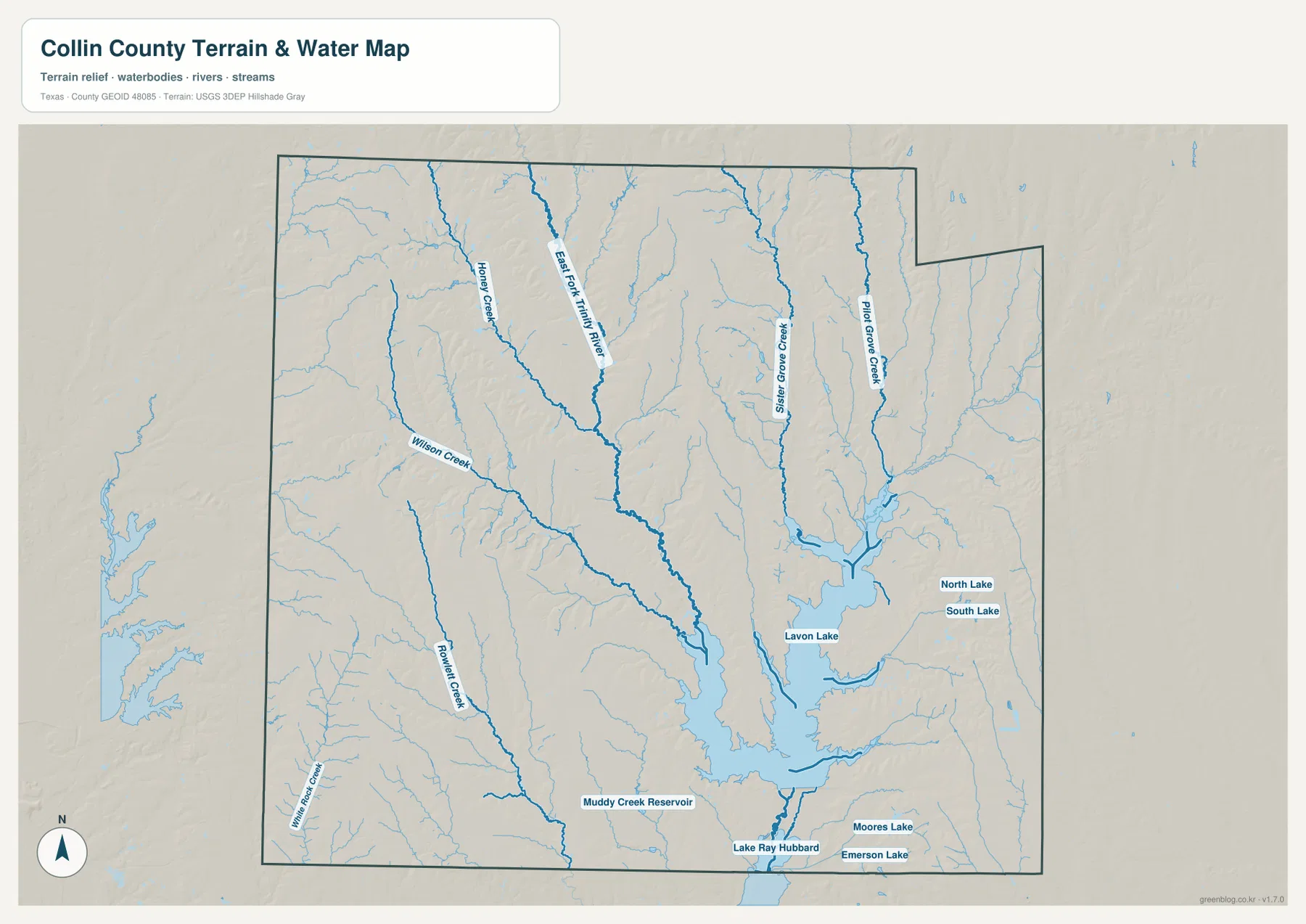
Collin County in North Texas combines one of the region’s densest suburban city clusters with a broad lake-and-creek landscape to the east. Plano, Frisco, Allen, and McKinney dominate the western and central part of the county map, while Princeton and Wylie sit closer to Lavon Lake and the East Fork Trinity River drainage. US 380 provides a strong east-west reference through McKinney toward Princeton, and State Highway 121 crosses another major part of the county. The terrain-and-water map adds East Fork Trinity River, Sister Grove Creek, Pilot Grove Creek, Honey Creek, Lavon Lake, and several smaller reservoirs and lakes. Elevation ranges from about 132 to 250 meters with a mean near 189 meters, showing a clear contrast between higher western ridges and the lower drainage country around Lavon Lake. The county, city, water, and elevation maps are available together as four high-resolution A3 JPG files in the ZIP download on this page.
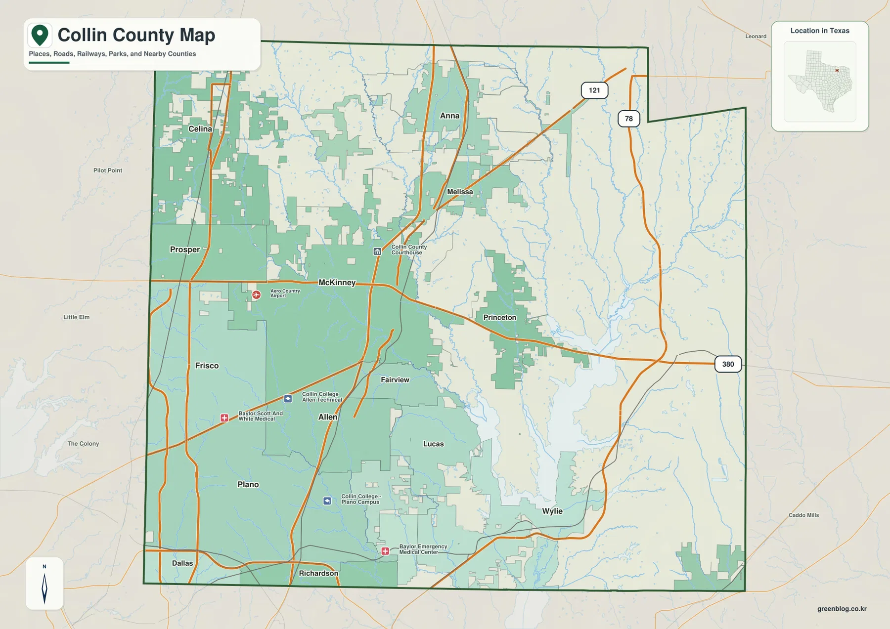
McKinney is the most useful place to establish orientation. It lies near the county center, with Frisco and Prosper to the west, Allen and Plano to the south, Melissa and Anna to the north, and Princeton to the east. Wylie is farther south near the lake-and-creek network. The western and southwestern cities appear almost continuous on the general map, while the eastern half opens into larger rural spaces and long drainage corridors. This west-to-east change is visible not only in settlement density but also in the elevation surface, where higher ridges give way to lower valleys.
Table of Contents
McKinney Connects the Plano–Allen Corridor with Frisco and Princeton
McKinney has one of the strongest road concentrations on the county map. US 380 crosses the city from west to east and continues toward Princeton, while the main north-south corridor links Allen and Plano with Melissa and Anna. Aero Country Airport is marked west of McKinney, and the Collin County Courthouse appears to the northeast of the central built-up area. These landmarks make McKinney easy to locate before the reader moves outward to the rest of the county.
West of McKinney, Frisco, Prosper, and Celina occupy a much more urbanized landscape. State Highway 121 forms another important diagonal reference through the county, and the road density around Frisco and the southwestern edge is substantially greater than in the east. Prosper lies between the Frisco side and McKinney’s western reach, while Celina extends the settlement pattern toward the northwestern boundary.
South of McKinney, Allen and Plano form a nearly continuous built-up corridor. Fairview and Lucas sit farther east, where urban development begins to break into larger open areas. Richardson and Dallas appear beyond the southern edge, showing how directly southwestern Collin County joins the Dallas urban region. Wylie, in the southeast, is separated from Plano and Allen by a more water-rich landscape associated with Lavon Lake and the lower creek system.
The eastern half is visibly less road-dense. Princeton sits on the US 380 route east of McKinney, but beyond it the map contains wider rural gaps and numerous blue drainage lines. Route 78 and State Highway 121 provide important references toward the northeastern and eastern side, yet the physical maps show that Sister Grove Creek, Pilot Grove Creek, and the Lavon Lake basin occupy far more of the landscape than the road map initially suggests.
Plano, Frisco, and McKinney Lead the Six-City Ranking
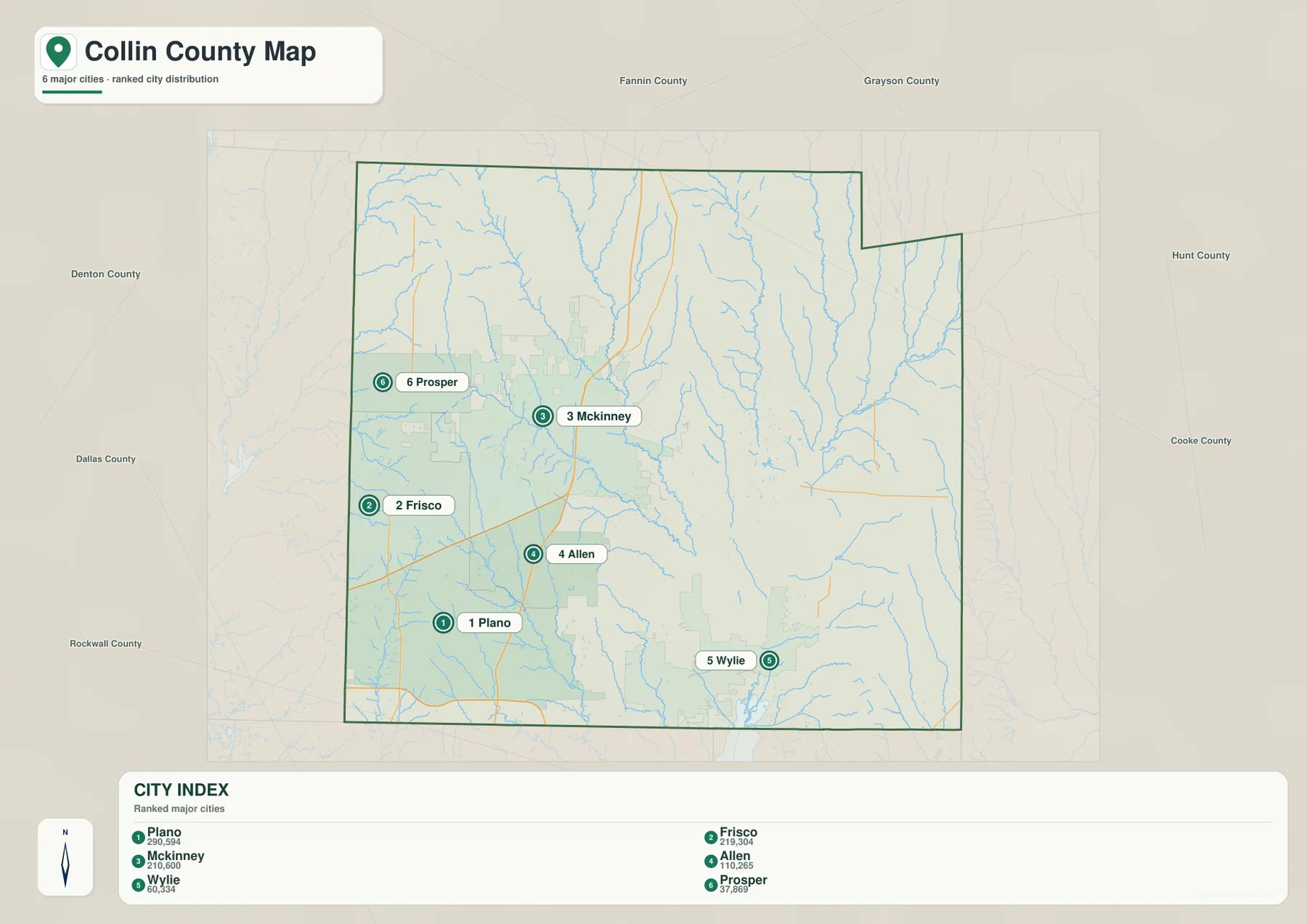
The ranked city map lists six communities. Plano is first at 290,594, Frisco second at 219,304, and McKinney third at 210,600. Allen follows at 110,265, Wylie at 60,334, and Prosper at 37,869. The distribution matters as much as the values: five of the six are concentrated in the western or central part of Collin County, while Wylie sits apart in the southeast.
Plano and Allen are close together near the southern edge, and Frisco lies to their northwest. McKinney is farther northeast and acts as a central bridge between the southwestern suburban cluster and the northern communities. Prosper sits north of Frisco and west of McKinney. Wylie is the outlier, positioned much closer to the lake-and-creek landscape that defines the southeastern county.
The city layer does not show connector lines or mileage labels, so the printed values should not be treated as distances or travel times. They are the figures shown in the supplied CITY INDEX. For transportation, the general county map is the better reference. For the physical setting between the cities, especially around Wylie, Princeton, and the eastern half, the water and elevation maps provide far more useful detail.
Neighboring county labels include Denton, Dallas, Rockwall, Hunt, Cooke, Grayson, and Fannin counties. Frisco and Prosper are close to the Denton County side, Plano lies near the Dallas County direction, and Wylie is close to Rockwall County. McKinney is more central, while the northern part of the county extends toward Grayson and Fannin counties. These relationships help explain why the six ranked cities connect to different parts of the wider North Texas region.
Lavon Lake Sits at the Center of the East Fork Trinity River Drainage
Lavon Lake is the dominant feature on the terrain-and-water map. It occupies a broad area in the southeastern interior and receives several long drainage lines from the north and northwest. East Fork Trinity River descends through the central-northern county toward the lake system, with Honey Creek running in a roughly parallel corridor farther west. The map makes the central countryside look completely different from the urban road layer because long blue valleys replace streets as the main visual structure.
Sister Grove Creek and Pilot Grove Creek are especially important in the eastern half. Both extend southward through long branching valleys, with Sister Grove closer to Lavon Lake and Pilot Grove farther east. Their tributaries divide the countryside north and east of Princeton into numerous narrow drainage corridors. This is one of the clearest physical differences between the suburban west and the more open eastern part of Collin County.
The southwestern side contains Wilson Creek and Rowlett Creek, while White Rock Creek is labeled beyond the western county edge. Muddy Creek Reservoir appears near the southern boundary, and Lake Ray Hubbard lies just beyond the county to the south. North Lake and South Lake are shown east of Lavon Lake, with Moores Lake and Emerson Lake farther southeast. These smaller water bodies help orient the lowland landscape when the larger Lavon Lake shoreline alone is too broad a reference.
This terrain-and-water map is intended for general geographic reference. It is not a flood-hazard map, parcel or legal-boundary map, depth chart, water-quality report, or navigation product. Those questions require specialized official data. For ordinary map reading, Lavon Lake, East Fork Trinity River, Sister Grove Creek, and Pilot Grove Creek provide the clearest framework for understanding the eastern half of the county.
Elevation from About 132 to 250 Meters Separates Western Ridges from the Lavon Lowlands
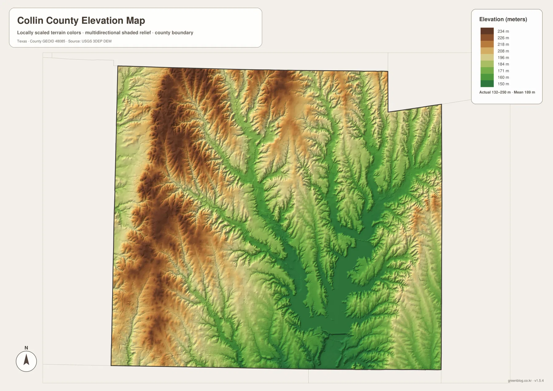
The supplied elevation map reports an actual range of approximately 132 to 250 meters and a mean near 189 meters. The highest dark-brown terrain is concentrated in the west and northwest, with another group of elevated ridges across the north-central area. Green lowlands become much more extensive toward the center and east, especially around the East Fork Trinity River system and Lavon Lake.
The western ridges are not one smooth upland surface. Numerous narrow green valleys cut through them, and several align with creek locations shown on the water map. Wilson Creek and Honey Creek provide useful examples. This helps explain why even the heavily urbanized Frisco–Plano–Allen side of the county is not perfectly flat; neighborhoods and roads occupy a gently rolling surface broken by local drainage.
Moving east, the lowland pattern becomes much more dominant. East Fork Trinity River occupies a broad green corridor, and Sister Grove and Pilot Grove creeks create separate low valleys farther east. Lavon Lake sits inside one of the largest low-elevation areas, with branching arms and tributary valleys extending outward like a network of fingers. The physical map therefore shows a strong basin-and-valley structure beneath the eastern rural landscape.
This elevation surface is suitable for county-scale comparison, not survey or engineering measurement. It should not be used to determine the precise elevation of a house, parcel corner, road grade, or construction site. The 132–250 meter range and 189 meter mean are best treated as broad reference values showing the contrast between western ridges, central drainage, and the low Lavon Lake basin.
The County Changes Sharply from the Urban Southwest to the Lake-and-Creek East
The strongest contrast in Collin County appears between the Plano–Frisco–Allen–McKinney side and the Lavon Lake–Princeton side. The general map shows dense roads and almost continuous built-up areas in the west and southwest, while the east contains larger rural gaps and a much more visible drainage network. The elevation map reinforces the same contrast, with higher western ridges giving way to lower creek valleys and the broad Lavon basin.
The McKinney-to-Princeton route along US 380 is a good example. On the road map it looks like a straightforward east-west connection. On the water map, the route approaches the East Fork Trinity system and other tributaries, and the elevation surface drops into increasingly broad green lowlands toward Lavon Lake. The physical setting changes even though the highway remains a simple visual line.
Wylie provides another useful comparison. It is one of the six ranked cities, yet it sits much closer to the lake network than Plano or Allen. Lavon Lake lies to the north and northeast, while the Lake Ray Hubbard system is visible farther south. The result is a city setting in which water and lowland terrain divide the surrounding landscape more strongly than they do in the continuous suburban corridor to the west.
Choosing the Best Collin County File for Roads, Cities, Water, or Relief
The general county map is the most complete single reference for Plano, Frisco, McKinney, Allen, Prosper, Princeton, Wylie, and the major road network. The ranked city map is cleaner when the goal is to compare the six selected communities and their distribution. The terrain-and-water map is the best choice for Lavon Lake, East Fork Trinity River, Sister Grove Creek, Pilot Grove Creek, and the smaller lakes. The elevation map most clearly explains the contrast between western ridges and the lower eastern drainage country.
Small creek labels and minor road details can be difficult to read in a reduced browser preview. The original JPG files are more convenient for enlargement and printing. They also work well for side-by-side comparison with Denton, Dallas, Rockwall, Hunt, Grayson, Fannin, or other North Texas counties when the same map type and similar display scale are used.
The ZIP below contains four high-resolution A3 JPG files corresponding to the county, city, water, and elevation maps shown in the article. They can be enlarged for detailed label reading, printed for classroom or personal reference, or arranged with neighboring county maps for regional comparison.
Frequently Asked Questions
Which city ranks first on the supplied Collin County city map?
Plano ranks first at 290,594 on the supplied CITY INDEX, followed by Frisco at 219,304 and McKinney at 210,600. Allen, Wylie, and Prosper are also shown, making the western and central concentration of the selected cities easy to compare.
Where are Lavon Lake and East Fork Trinity River on the map?
Lavon Lake occupies a broad area in the southeastern interior of Collin County. East Fork Trinity River descends through the central-northern county toward the lake system, while Sister Grove Creek and Pilot Grove Creek form additional long drainage corridors farther east.
Which part of Collin County is highest on the supplied elevation map?
The west and northwest contain much of the higher terrain. The map reports an elevation range of about 132–250 meters with a mean near 189 meters, while East Fork Trinity River, Lavon Lake, and the eastern creek valleys occupy lower ground.
Sources and Reference Data
- U.S. Census Bureau TIGER/Line Shapefiles — official geographic boundary, road, and place data.
- USGS National Hydrography — official information about rivers, creeks, lakes, and hydrography.
- USGS 3D Elevation Program — official elevation and terrain data information.
- USGS The National Map Viewer — interactive access to boundaries, transportation, hydrography, terrain, and other geographic layers.
Map File Information
Download the Collin County county, city, water, and elevation maps together as high-resolution A3 JPG files.
- Included Files: 4 maps
- File Type: JPG
Related Maps
- Rockwall County Texas map
- Tarrant County Texas map
- Wise County Texas map
- Rains County Texas map
- Van Zandt County Texas map
Green Map creates custom-edited map images using open geographic data sources such as geoBoundaries, Natural Earth, OpenStreetMap, and government open data.
These maps are edited visual materials, not raw data files, and are provided for education, documents, presentations, and graphic reference.