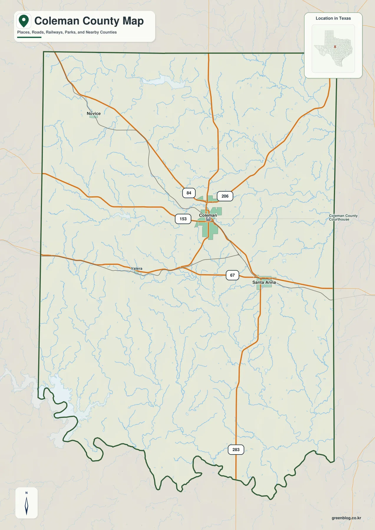
Coleman County in west-central Texas has a clear contrast between its higher western uplands and the lower country toward the east and southeast. Coleman sits near the center of the road network, Santa Anna lies to the southeast, and Novice is farther northwest. US 84 and routes 153 and 206 meet around Coleman, while Route 67 provides a strong reference through Santa Anna. The water map adds Hords Creek Lake, Lake Coleman, Lake Scarborough, the Colorado River, and a dense network of named creeks. The elevation surface ranges from about 392 to 687 meters with a mean near 518 meters, revealing much stronger relief than the road map alone suggests. The county, city, water, and elevation maps shown in the article are also available as four high-resolution A3 JPG files in a single ZIP download.
For orientation, locate Coleman first and then compare Santa Anna and Novice. Coleman is close to the center of the county, Novice sits northwest along the US 84 side, and Santa Anna occupies the southeast near Route 67. Valera provides another reference southwest of Coleman on the general county map. Once these places are familiar, the terrain maps become easier to understand because the broad rural spaces between them resolve into ridges, creek valleys, reservoirs, and a much lower Colorado River corridor near the southern edge.
Table of Contents
Coleman Is the Road Hub for US 84, Route 153, and Route 206
Coleman is the most obvious built-up area on the general county map. US 84 approaches from the northwest, crosses the town, and continues toward the southeast. Route 153 comes in from the west, while Route 206 reaches the Coleman area from the north and east. The Coleman County Courthouse is marked on the eastern side of town, providing an easy administrative landmark close to the road concentration.
Santa Anna lies southeast of Coleman. Route 67 passes through the community and joins the broader east-west transportation pattern. South of Santa Anna, Route 283 continues toward the southern county line and provides a useful reference for the more sparsely settled rural area. The road network thins quickly away from the towns, and small streams become much more visually important on the terrain map.
Novice is farther northwest, close to the US 84 route through the northern half of the county. The land between Novice and Coleman does not contain a continuous urban corridor; creeks and rolling uplands occupy most of the space. Valera, southwest of Coleman, provides a smaller reference on the long road crossing the western-central part of the county. Together, these places show that settlement is dispersed around one main hub rather than lined up in a single developed strip.
The southern edge becomes much more irregular near the Colorado River. In the southwest, the boundary bends sharply with the river and associated lowland. The northern and eastern edges contain longer straighter segments. This contrast is important because the road map can make the southern countryside appear simple, while the water and elevation maps reveal many deeply cut tributaries and a large change in height near the river system.
The City Map Shows Santa Anna 9 Miles and Novice 16 Miles from Coleman
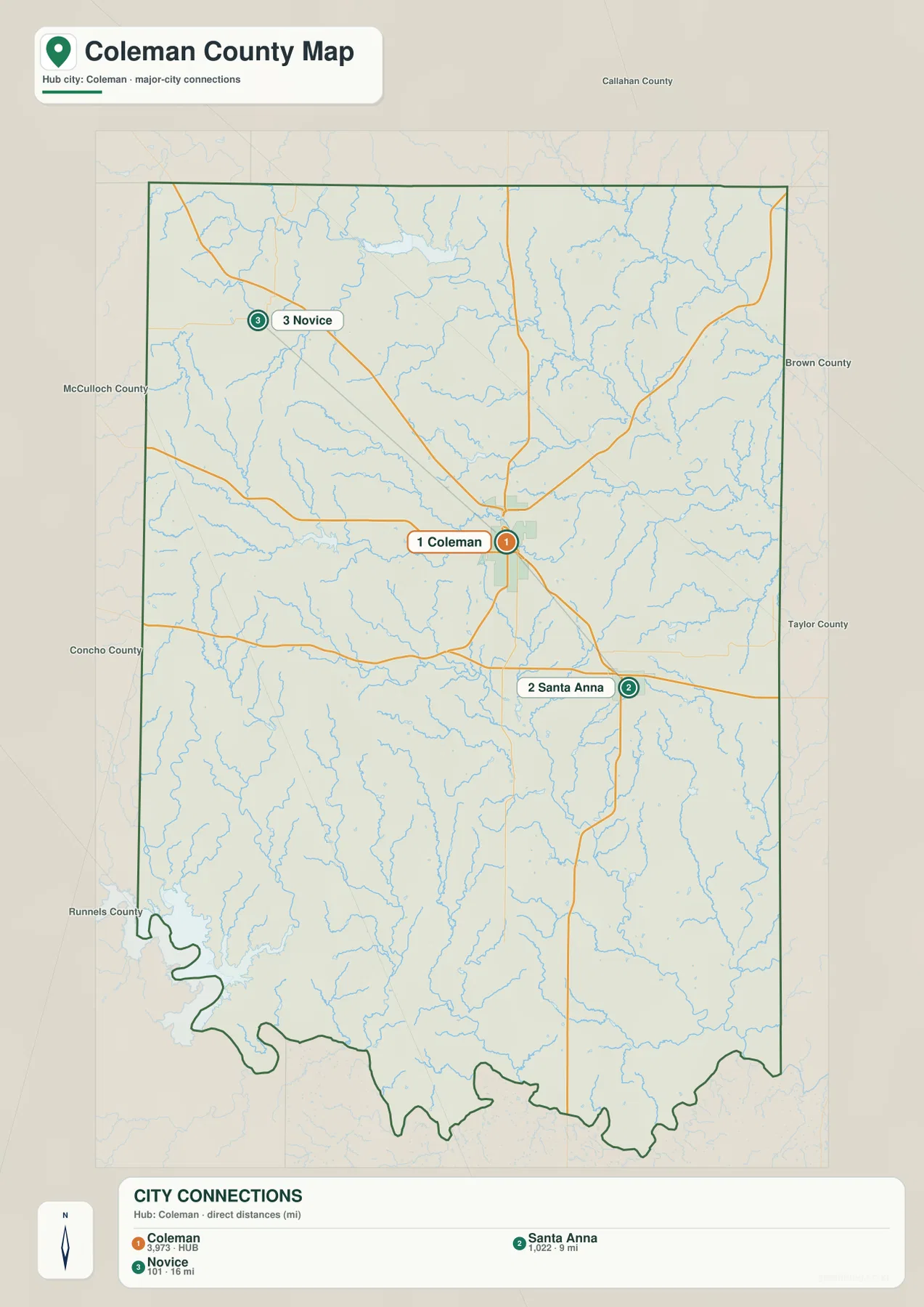
The city-connections map removes most minor road detail and focuses on three communities. Its lower index lists Coleman at 3,973 as the hub, Santa Anna at 1,022, and Novice at 101. Coleman is plotted close to the center, Santa Anna southeast, and Novice northwest. The arrangement makes it immediately clear that the two smaller communities lie in nearly opposite directions from the hub.
The mileage labels are direct point-to-point distances, not driving distances. The map shows about 9 miles from Coleman to Santa Anna and about 16 miles from Coleman to Novice. Actual road travel may be longer depending on the route and the exact starting and ending points. These straight-line values are still useful because they provide a quick sense of scale before the reader returns to the county map to trace US 84 and the route toward Santa Anna.
Neighboring county labels add regional orientation. Callahan and Taylor counties are visible toward the northern side of the broader view, Brown County lies east, and Runnels, Concho, and McCulloch counties frame the western and southern sides. Novice is closer to the northern and northwestern side of Coleman County, while Santa Anna provides a stronger reference for the Brown County direction. The hub-and-spoke city map makes those relationships easier to see than a road-heavy image.
Valera appears on the general county map but not on the city-connections layer. This is a useful reminder that the city map is not a complete ranked list of every named settlement. Its purpose is to show the selected hub connections. For a complete local road picture, the county map should be used alongside it, especially when the location of Valera or other smaller references matters.
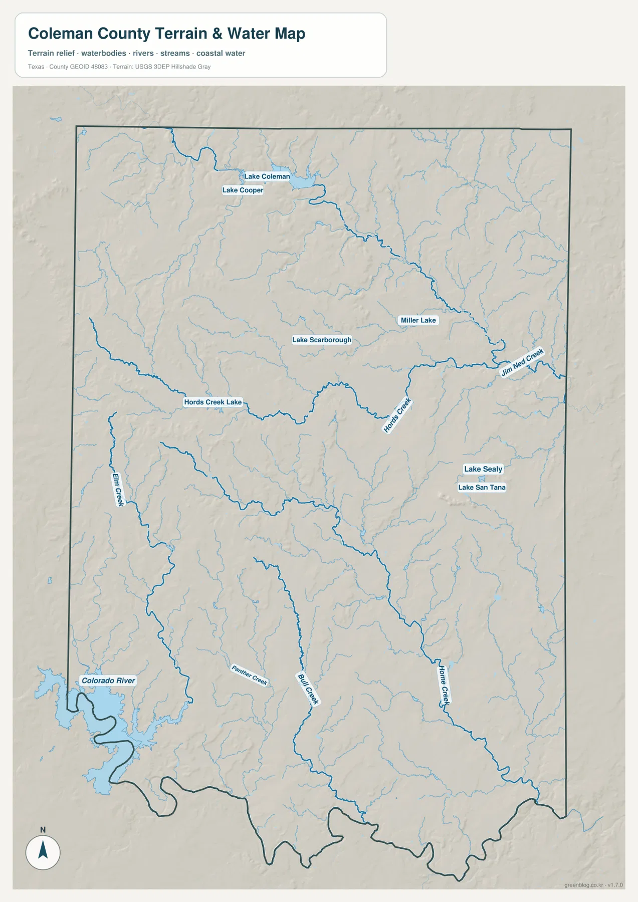
Hords Creek Lake, Lake Coleman, and the Colorado River Define the Water Map
Hords Creek and Hords Creek Lake are among the clearest water references in the western-central part of the supplied map. Hords Creek bends through the interior before widening into the named lake. Because Coleman is not far from this system, the lake becomes a useful reference when comparing the town and road map with the terrain-and-water image. The current preview labels the feature as Hords Creek Lake, while the earlier article title used Hords Creek Reservoir for the same well-known local water reference.
Farther north, Lake Coleman and Lake Cooper appear close together, with a long drainage extending southeast from that area. Lake Scarborough sits nearer the county center, and Miller Lake is farther east. Jim Ned Creek provides one of the strongest named channels in the eastern half and runs toward the county boundary. These features show that the northern and central sections contain many recognizable local water landmarks rather than one dominant river alone.
The southern half contains a different set of long creeks. Elm Creek follows the western side, while Panther Creek, Bull Creek, and Home Creek run through separate valleys farther east. Lake Sealy and Lake San Tana are labeled near the Santa Anna side. The Colorado River appears along the southwestern boundary and is the largest river reference in that part of the map, where the county line becomes highly irregular.
This terrain-and-water image is intended for general geographic reference. It is not a flood-hazard map, parcel or legal-boundary map, depth chart, water-quality report, or navigation product. Those uses require purpose-built official information. For ordinary map reading, Hords Creek Lake, Lake Coleman, Jim Ned Creek, and the Colorado River provide a strong framework for locating the smaller tributaries and comparing them with roads and elevation.
Elevation from About 392 to 687 Meters Drops Sharply from West to East
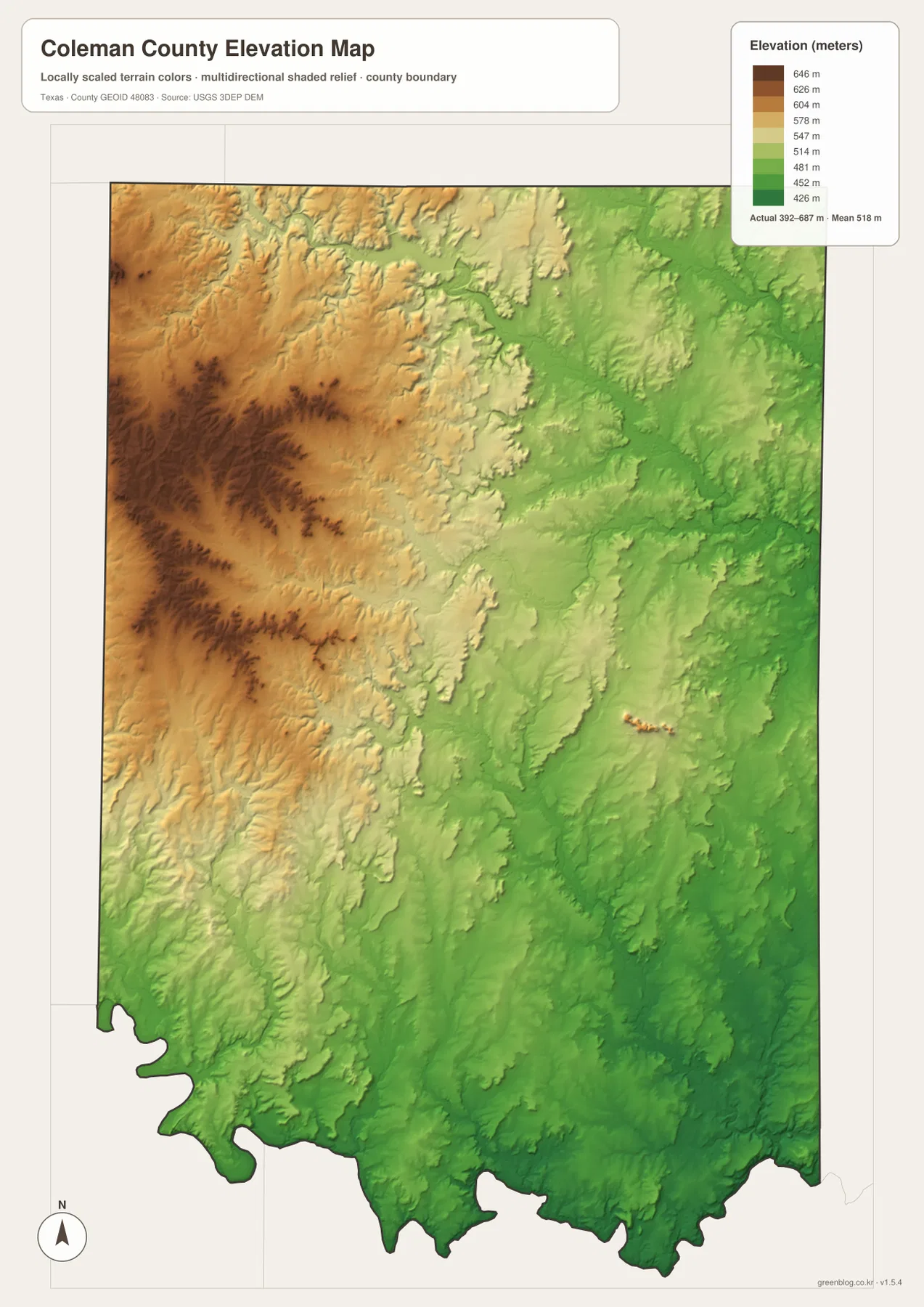
The supplied elevation map reports an actual range of approximately 392 to 687 meters and a mean near 518 meters. The highest dark-brown terrain is concentrated across the west and northwest, where long ridges dominate the surface. The eastern and southeastern parts are much greener and generally lower. A difference of almost 300 meters within one county gives Coleman County a pronounced west-to-east relief contrast.
The western uplands are not one smooth plateau. High ridges are cut by narrow yellow and green valleys, many of which match creek locations visible on the water map. Elm Creek, Panther Creek, and tributaries toward Hords Creek occupy lower corridors within the higher ground. As those valleys approach the central drainage, the surface drops quickly and the terrain becomes more dissected.
Moving east from Coleman, the overall elevation decreases, but small ridges remain throughout the landscape. The Santa Anna side is generally lower than the high western county, while Jim Ned Creek and other eastern channels occupy long green valleys. The Colorado River corridor along the south and southwest also sits below the nearby uplands, with low terrain following the river’s bends near the county boundary.
The elevation surface is designed for county-scale comparison, not survey or engineering measurement. It should not be used to determine the exact elevation of a house, parcel corner, road grade, or construction site. The 392–687 meter range and 518 meter mean are most useful as broad references for understanding how high western ridges, central creek valleys, and lower eastern and river corridors differ across Coleman County.
The Coleman–Santa Anna Route Looks Different Once Water and Relief Are Added
On the county map, the route from Coleman toward Santa Anna appears to be a fairly straightforward southeast connection. The physical maps add a more complex setting. Numerous tributaries cross the surrounding countryside, and elevation declines from the higher western side toward lower southeastern terrain. Route 67 and the connecting roads therefore pass through a sequence of small ridges and creek valleys rather than a perfectly level plain.
The Novice direction has a different character. Traveling northwest from Coleman brings the map closer to higher ground and to the Lake Coleman drainage. The city-connections map simplifies this relationship to a 16-mile straight line, but the water and elevation layers show how much rolling terrain occupies the space between the two communities. This makes Novice a useful reference for understanding the higher northern and northwestern part of the county.
Southwest of Coleman, Valera and the Colorado River side shift attention away from towns and toward physical geography. Elm Creek and Panther Creek descend from higher western ground toward lower valleys, and the county boundary becomes irregular near the river. Coleman County therefore contains several distinct map settings: a central road hub, higher northwest uplands, lower terrain toward Santa Anna, and a strongly incised river-and-creek landscape in the southwest.
Choosing the Best Coleman County File for Roads, Distances, Water, or Relief
The general county map is the most useful single image for Coleman, Santa Anna, Novice, Valera, US 84, and the main numbered roads. The city-connections map is cleaner when the goal is to compare directions and the 9- and 16-mile straight-line distances from Coleman. The terrain-and-water map is the best choice for Hords Creek Lake, Lake Coleman, Jim Ned Creek, the Colorado River, and the smaller named creeks. The elevation map most clearly explains the contrast between the high western uplands and the lower eastern and river valleys.
Small creek labels and minor road numbers can be difficult to read in a reduced browser preview. The original JPG files are more convenient for enlargement and printing. They also work well for side-by-side comparison with Runnels, Taylor, Brown, Callahan, Concho, McCulloch, or other west-central Texas counties when the same map type and similar display scale are used.
The ZIP below contains four high-resolution A3 JPG files corresponding to the county, city, water, and elevation maps shown in the article. They can be enlarged for detailed label reading, printed for classroom or personal reference, or arranged with neighboring county maps for regional comparison.
Frequently Asked Questions
Are the 9-mile and 16-mile city-connection labels driving distances?
No. The supplied city-connections map shows straight-line distances of about 9 miles from Coleman to Santa Anna and 16 miles from Coleman to Novice. Actual road mileage depends on the chosen route and the exact starting and ending points.
Which water features are easiest to identify on the Coleman County map?
Hords Creek Lake is a strong reference west of the county center, Lake Coleman is prominent in the north, Jim Ned Creek crosses the eastern side, and the Colorado River follows the southwest boundary. Elm, Panther, Bull, and Home creeks provide additional southern drainage references.
Which part of Coleman County is highest on the supplied elevation map?
The west and northwest contain much of the highest terrain. The map reports an elevation range of about 392–687 meters with a mean near 518 meters, while the east, southeast, major creek valleys, and Colorado River corridor occupy lower ground.
Sources and Reference Data
- U.S. Census Bureau TIGER/Line Shapefiles — official geographic boundary, road, and place data.
- USGS National Hydrography — official information about rivers, creeks, lakes, and hydrography.
- USGS 3D Elevation Program — official elevation and terrain data information.
- USGS The National Map Viewer — interactive access to boundaries, transportation, hydrography, terrain, and other geographic layers.
Map File Information
Download the Coleman County county, city, water, and elevation maps together as high-resolution A3 JPG files.
- Included Files: 4 maps
- File Type: JPG
Related Maps
- Runnels County Texas map
- Taylor County Texas map
- San Saba County Texas map
- Shackelford County Texas map
- Schleicher County Texas map
Green Map creates custom-edited map images using open geographic data sources such as geoBoundaries, Natural Earth, OpenStreetMap, and government open data.
These maps are edited visual materials, not raw data files, and are provided for education, documents, presentations, and graphic reference.