This Shackelford County Map set uses Albany as the main reference point for understanding roads, communities, waterways, and terrain across the county. Moran sits near the southeastern edge, U.S. 180 crosses the county through Albany, and the water map brings the Clear Fork Brazos River and the Hubbard Creek system into focus. The maps can be viewed directly in the article, and the download box below provides matching high-resolution A3 JPG files for printing or editing.
The strongest contrast in Shackelford County is not between several large towns. It is between the higher, more rugged western half and the lower eastern valleys. Albany lies close to the transition between those two landscapes. Once Albany and Moran are located on the road map, the water and elevation maps explain why the county’s streams bend through so many narrow valleys and why the eastern side looks noticeably greener on the relief map.
Table of Contents
U.S. 180 makes Albany the easiest place to orient the county
Albany appears slightly east of the county’s center and is the most useful anchor on the general reference map. U.S. 180 crosses the county from west to east through the Albany area. State Highway 6 runs south from Albany toward Moran. North of Albany, route shields 283 and 283N are visible, while 351 appears to the southwest. Rather than memorizing every number, the map becomes easier to read by following the roads outward from Albany.
Moran is well southeast of Albany and close to the county boundary. Sedwick is labeled along the same general southeastern direction, while Lueders appears beyond the western edge of the county. Berryhill is marked farther northwest. These surrounding place labels help show that Albany is not simply a point in the center; it sits where east-west and north-south movement can be compared across a broad rural county.
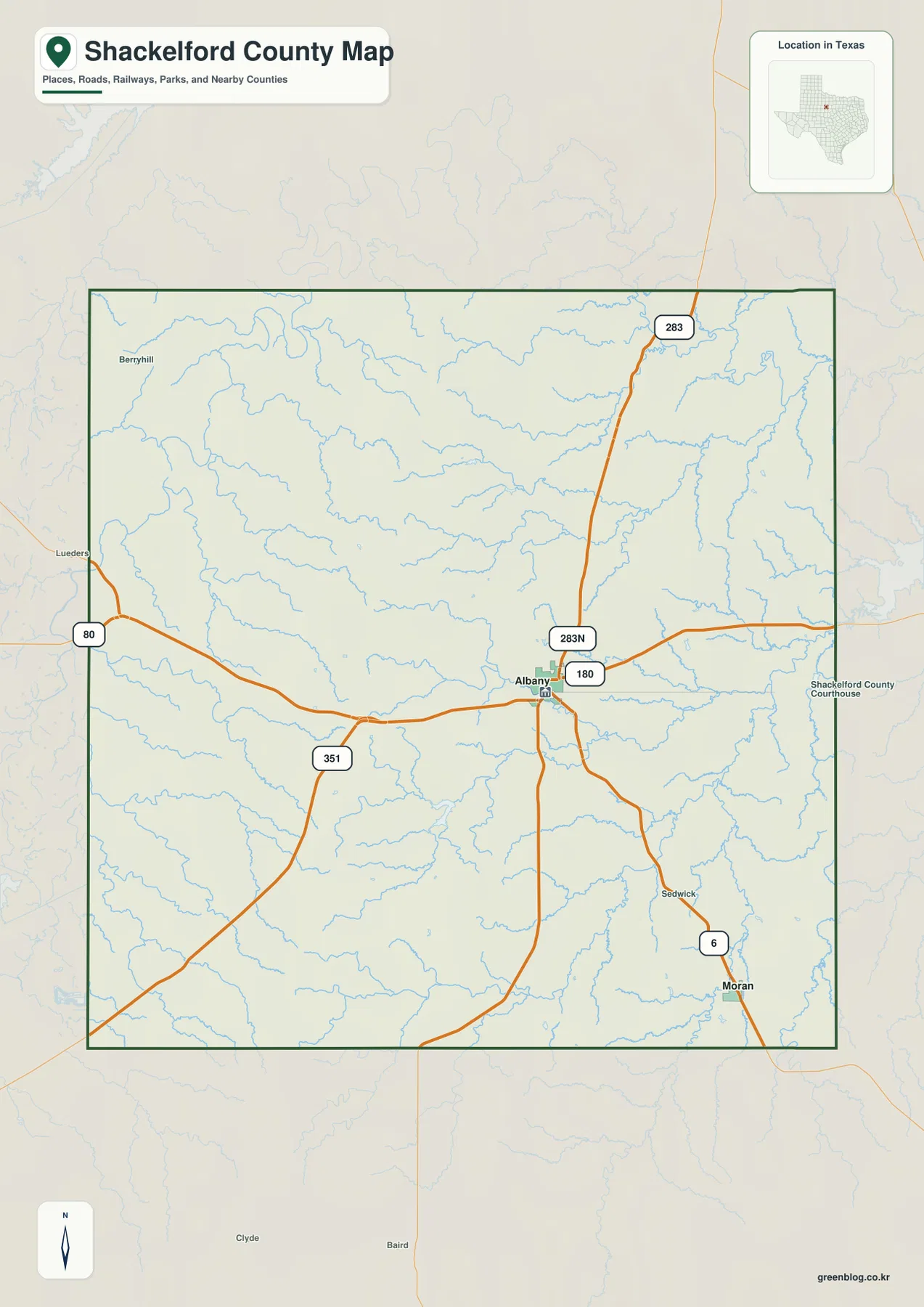
The outer boundary is fairly regular, but the interior stream pattern is much more intricate. Small blue channels branch across the north, east, and south, so the county looks very different when roads are removed and water is emphasized. This is why the reference map works best as a starting point: it establishes Albany, Moran, and the road network before the terrain-and-water map adds the natural detail.
Albany and Moran mark two very different parts of the county
The ranked city map reduces the settlement layer to Albany and Moran. Albany is positioned in the central-eastern part of the county, while Moran is close to the southeast boundary. Their separation is immediately visible when the secondary roads and place labels are removed. For a classroom handout or simple county overview, this version gives a cleaner sense of where the two principal mapped communities sit.
The CITY INDEX printed at the bottom lists Albany at 1,849 and Moran at 259. Those are the values used by the supplied map to rank the two places. They should not be treated as guaranteed current population estimates; anyone who needs the latest demographic total should use an official statistical source. For map reading, however, the index explains why Albany is marked number 1 and Moran number 2.
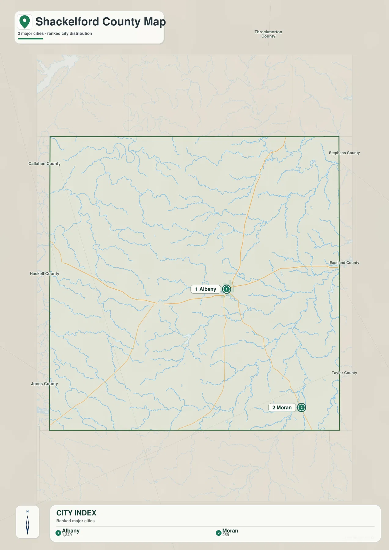
The simplified city view also leaves the surrounding county labels visible, which helps with regional orientation without overcrowding the map. Once Albany is fixed as the central reference and Moran as the southeastern point, the water map becomes easier to read because features such as Hubbard Creek and Moran Lake can be placed in relation to those settlements rather than treated as isolated names.
Clear Fork Brazos River dominates the northeastern drainage
The terrain-and-water map gives the strongest visual emphasis to the Clear Fork Brazos River in the northeast. The river bends through the upper-right part of the county, with Mill Creek and Foyle Creek approaching from the west. Nail Lake No 2 is labeled in the north-central interior, while Fish Creek crosses farther west. Compared with the straight road lines on the reference map, these channels show how strongly the natural terrain controls the shape of the drainage network.
Farther south and east, Salt Prong Hubbard Creek forms a long central channel before meeting the larger Hubbard Creek system near the eastern side. Long Creek and Spring Creek are visible in the south and southwest, and several named lakes appear closer to the lower boundary. Mc Carty Lake sits in the south-central interior, while Diller Lake and Snyder Lake are farther south and Moran Lake is near the southeastern corner.
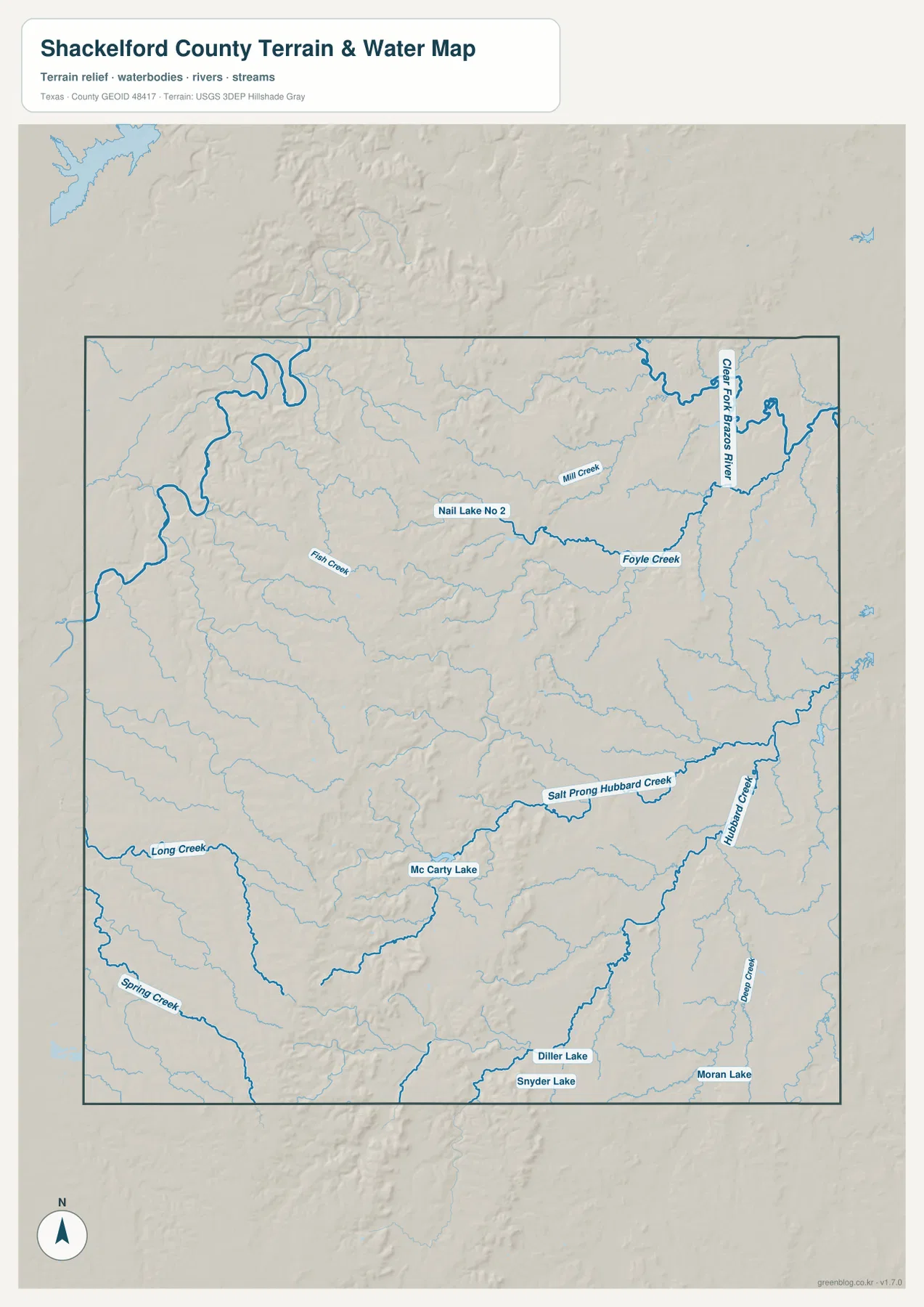
A simple way to read the water map is to separate the northeast Clear Fork Brazos system from the Hubbard Creek drainage farther south and east. The smaller western and southern creeks fill the valleys between those two references. This map is intended to show geographic water and terrain relationships; it is not a flood-risk map, parcel map, legal-boundary product, or navigation chart.
The western uplands stand far above the eastern valleys
The elevation map reports an actual range of about 348 to 621 meters and a mean elevation of 471 meters. Brown and tan colors dominate much of the western half, including a broad band of rugged higher ground through the west-central interior. The eastern half is much greener, indicating lower terrain. The west-to-east contrast is strong enough that it can be understood immediately without reading individual contour values.
The western upland is not a flat plateau. Narrow valleys cut deeply into the higher surface, producing a dense pattern of ridges and drainage lines. Moving east, the high brown terrain gives way to yellow-green and then broader green areas. When the elevation and water maps are compared, the lower corridors align with the same general areas occupied by the Clear Fork Brazos River, Hubbard Creek, and smaller tributaries.
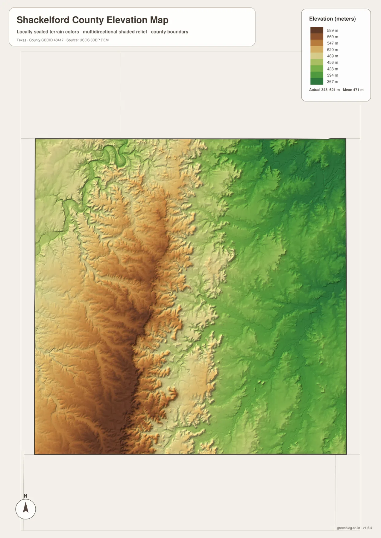
This countywide elevation surface is intended for broad comparison rather than survey or engineering work. It is useful for seeing which parts of the county are relatively high, where creek valleys cut through the uplands, and how the terrain changes from west to east. A project that needs a precise elevation for a parcel or structure should use detailed source data or a local survey.
Choose the map according to whether roads or terrain matter most
Use the county reference map when Albany, Moran, U.S. 180, State Highway 6, and the county boundary need to appear together. The ranked city map is cleaner when only the two principal settlements should stand out. Choose the terrain-and-water map for the Clear Fork Brazos River, Hubbard Creek, Foyle Creek, and the named lakes, and use the elevation map when the contrast between western uplands and eastern valleys is the main subject.
The WebP images in the article are convenient for quick on-screen viewing. For printing or editing, the ZIP below contains four matching high-resolution A3 JPG files: county reference, ranked city, terrain and water, and elevation. Because the maps remain separate files, you can print only the one needed for a classroom handout, local reference page, presentation, or personal project.
Frequently Asked Questions
Where is Moran in relation to Albany?
On the supplied maps, Moran is southeast of Albany and close to the county boundary. State Highway 6 runs from the Albany area toward Moran, making the relationship easy to follow on the reference map.
Where is the Clear Fork Brazos River on the map?
The Clear Fork Brazos River is the strongest named watercourse in the northeastern part of the terrain-and-water map. Mill Creek and Foyle Creek approach the same general drainage area from the west.
What elevation range is shown for Shackelford County?
The supplied elevation map states an actual range of about 348 to 621 meters and a mean of 471 meters. The western half is generally much higher, while broad lower valleys dominate the east.
Map File Information
The ZIP contains the four Shackelford County maps in high-resolution A3 JPG format.
- Included Versions: County reference, ranked city, terrain and water, elevation
- Included Files: 4 A3 JPG maps
Related Maps
Sources and data references
County boundaries and road reference data can be checked through the U.S. Census Bureau TIGER/Line Shapefiles. Rivers, creeks, and other hydrographic features can be cross-checked with USGS National Hydrography, while elevation data are available through the USGS 3D Elevation Program. The city index values, road labels, named waters, and elevation figures described above are based on the Shackelford County maps supplied in the current ZIP package.
Green Map creates custom-edited map images using open geographic data sources such as geoBoundaries, Natural Earth, OpenStreetMap, and government open data.
These maps are edited visual materials, not raw data files, and are provided for education, documents, presentations, and graphic reference.