Brookhaven is the easiest place to orient yourself on a map of Lincoln County, Mississippi. I-55 and US 51 run north and south through the county, while US 84 crosses them at Brookhaven and continues toward neighboring counties on both sides. The downloadable maps on this page add three other views to that road-and-boundary picture: a city-focused map, a water map, and an elevation map. Together they show why Lincoln County is not simply a highway junction on a flat surface, but a rolling Piney Woods county cut by the Bogue Chitto system and many smaller stream valleys.
The county had 34,907 residents in the 2020 census, and the July 2025 estimate listed in the supplied material is 35,012. The 2025 Gazetteer figures give 586.207 square miles of land and 2.043 square miles of water. Those countywide numbers provide scale, but the maps add the part that a table cannot: Brookhaven is the dominant labeled city, major roads converge there, and the rest of the county is a much more dispersed mixture of small communities, ridges, wooded uplands, and creek bottoms. High-resolution A3 JPG copies of all four supplied maps are available together in the ZIP file below.
Table of Contents
Brookhaven as the practical reference point for Lincoln County
The county map places Brookhaven near the north-central part of Lincoln County and makes the road pattern immediately understandable. I-55 and US 51 follow the same general north-south corridor, passing through Brookhaven and continuing toward Bogue Chitto farther south. US 84 crosses Brookhaven from west to east. MS 550 approaches from the northwest, and MS 583 provides a prominent route toward the southeast. Additional route shields visible around the county include US 184 to the east and MS 569 and MS 98 near the southwestern edge.
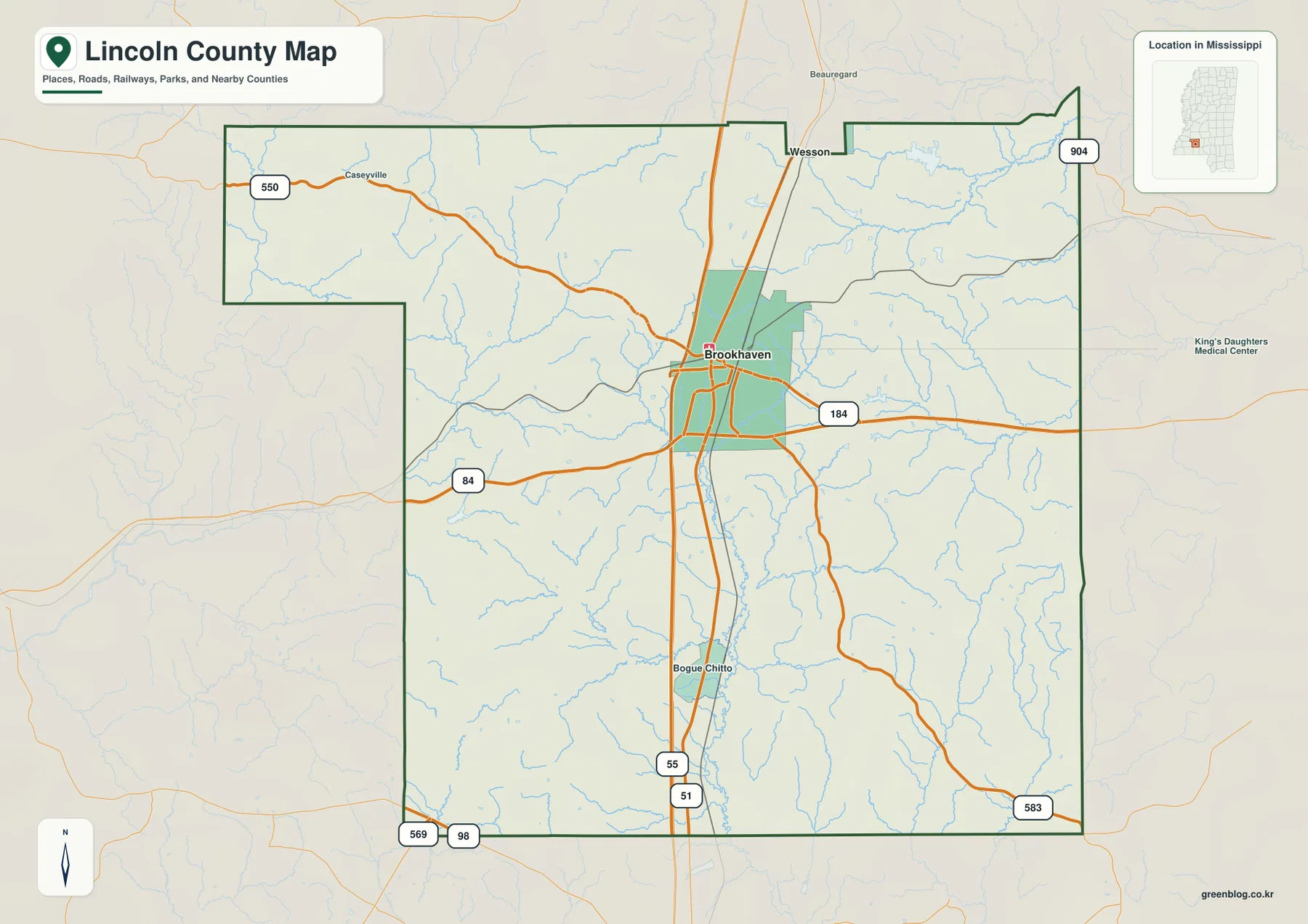
This road arrangement also helps explain the outside labels. Wesson and Beauregard appear beyond the northern county line, while Bogue Chitto is shown inside the county to the south of Brookhaven. Following I-55 north leads toward Copiah County; following it south leads toward Pike County. US 84 gives a useful east-west comparison because Franklin County lies to the west and Lawrence County lies to the east. The map therefore works well when the question is not just “Where is Brookhaven?” but “Which direction does a trip continue after leaving Brookhaven?”
| Reference | Value or feature shown in the supplied material |
|---|---|
| County seat | Brookhaven |
| FIPS code | 28085 |
| 2020 census population | 34,907 |
| July 2025 population estimate | 35,012 |
| 2025 land area | 586.207 square miles |
| 2025 water area | 2.043 square miles |
| Principal road references | I-55, US 51, US 84, MS 550, MS 583 |
| Elevation map range | About 70–174 meters; mean about 130 meters |
Using the 2020 population with the supplied 2025 land-area figure gives a countywide density of about 59.5 residents per square mile. That is useful only as a broad scale indicator. It should not be read as though people are spread evenly across the county. The city and road maps show a much more concentrated pattern around Brookhaven, while large parts of the county away from the main corridors contain fewer labeled places and a denser network of small streams and ridges.
A one-city index framed by seven neighboring counties
The city map is unusually simple because its CITY INDEX lists only one major city: Brookhaven, with a printed population value of 11,650. That simplicity is informative. Instead of presenting several similarly sized urban centers, the map emphasizes a single dominant city and then uses the county boundary and surrounding county names to establish regional direction. Brookhaven sits above the geographic midpoint of the main county body, with the city area clustered around the road junction rather than spread evenly across the county.
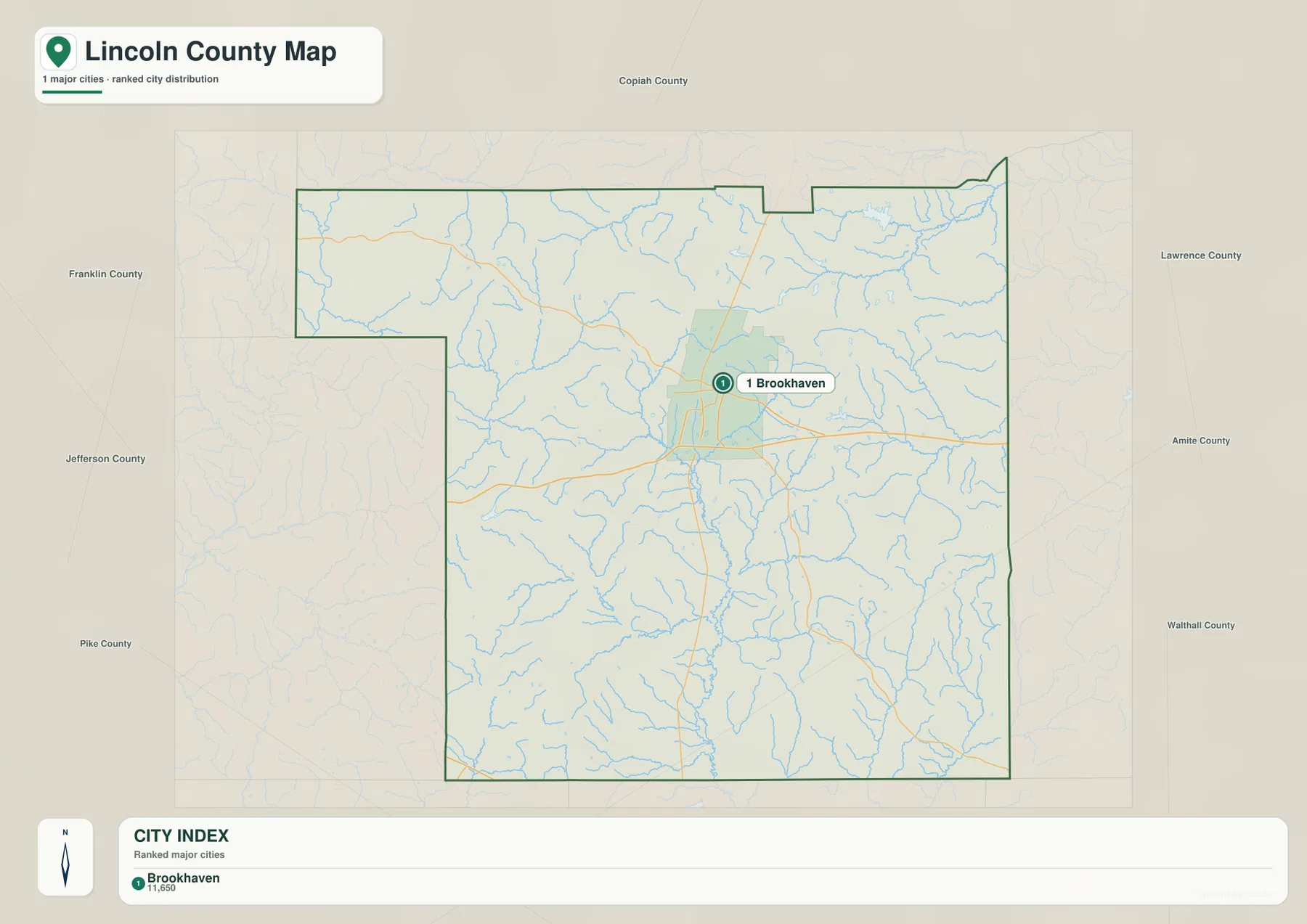
Copiah County is labeled to the north. Lawrence County lies to the upper east, with Amite County and Walthall County farther down the eastern side. Pike County is to the southwest, Jefferson County to the west, and Franklin County to the northwest. This surrounding frame is especially helpful when the county map is being used for travel orientation. A driver leaving Brookhaven on I-55 can quickly distinguish the Copiah County direction from the Pike County direction, while US 84 separates the Lawrence County side from the Franklin County side.
Wesson is a good example of why the boundary matters. It appears close to Lincoln County on the general county map, but it is north of the county line in Copiah County. Without the surrounding-county labels, a nearby place can easily look like part of Lincoln County simply because it is close to Brookhaven. The city view reduces that ambiguity. It is therefore the better choice when the main question is administrative position rather than detailed road names or stream locations.
West and East Bogue Chitto branches converge through the county
The water map reveals a feature that is easy to miss on the road map: Lincoln County contains a dense drainage network, and the Bogue Chitto system forms the clearest central structure. West Bogue Chitto River and East Bogue Chitto River descend from the northern half of the county and meet near the middle. From there, Bogue Chitto River continues south toward the county line. The central river corridor also corresponds with lower terrain on the elevation map, so the water and relief views reinforce each other rather than telling separate stories.
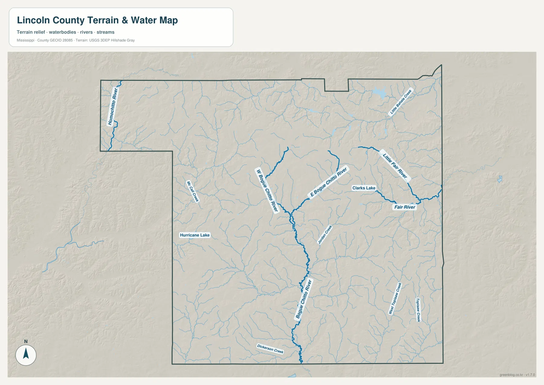
The eastern half has its own recognizable water features. Fair River and Little Fair River appear near the eastern side, and Clarks Lake is labeled between the main stream lines. Little Bahala Creek is shown near the northeast. Jordan Creek appears farther south near the center-east, while Middle Prong Creek and Topisaw Creek are labeled in the southeastern area. Dickerson Creek reaches the southern edge, and McCall Creek is visible on the western side. The Homochitto River label at the northwest edge adds a useful regional reference beyond the central Bogue Chitto drainage.
The repeated Bogue Chitto name can be confusing at first because it applies to both a community and a river system. On the county map, Bogue Chitto is a place south of Brookhaven along the I-55/US 51 corridor. On the water map, West Bogue Chitto River and East Bogue Chitto River are separate branches that combine into Bogue Chitto River. Checking the place map first and the hydrography map second keeps those two uses of the name clear. The water map is a location reference, not a flood-risk, navigation, parcel, or legal-boundary product.
Rolling relief from about 70 to 174 meters
The elevation map changes the impression of Lincoln County more than any of the other views. Rather than showing a broad, nearly level surface, it displays many short ridges separated by branching valleys. The actual range printed on the map is about 70 to 174 meters, with a mean elevation of about 130 meters. Brown and tan areas mark higher ground within the locally scaled display, while green corridors trace lower terrain. The result is a clear picture of the rolling Piney Woods landscape described in the supplied county material.
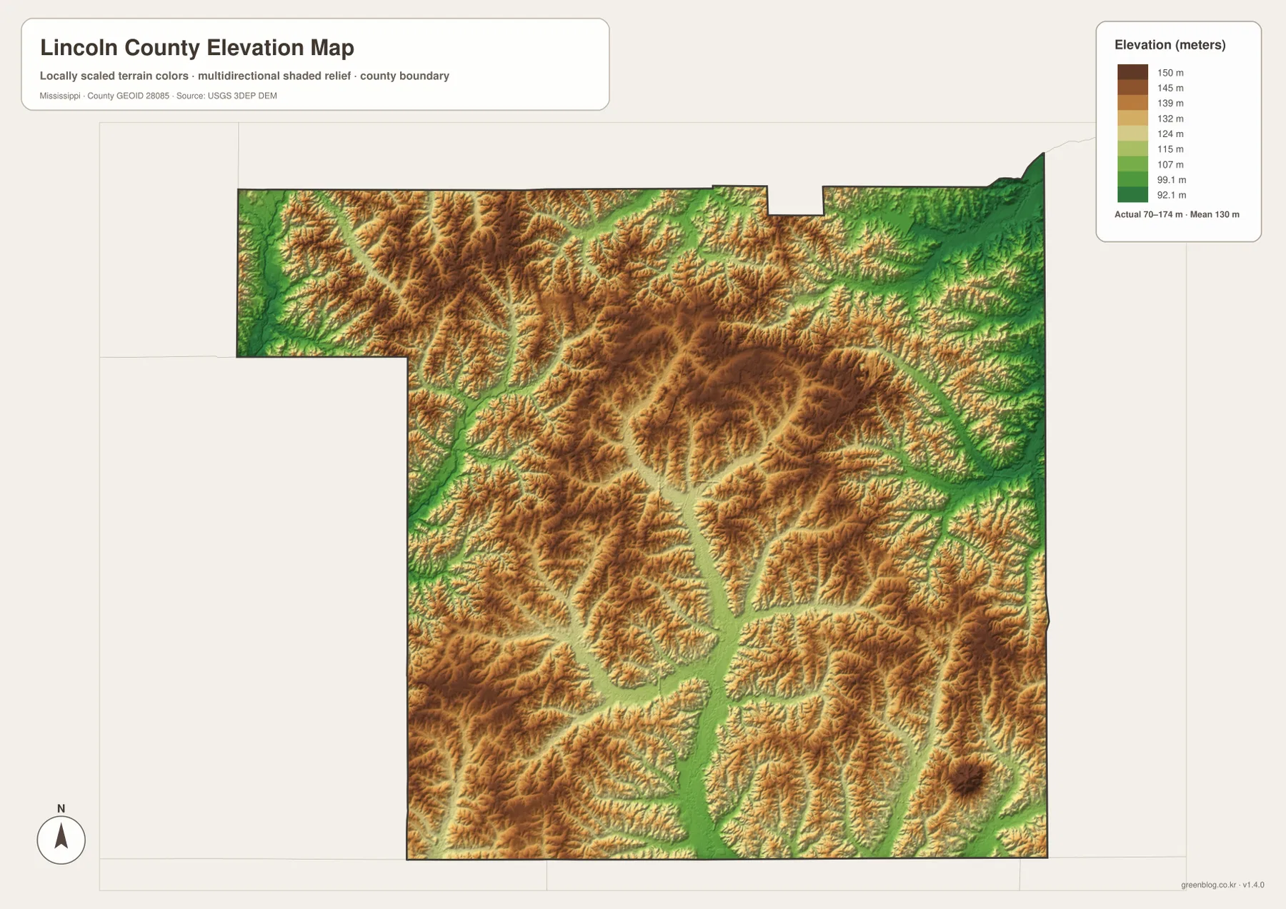
The lower north-south corridor through the central part of the county aligns with the Bogue Chitto drainage, and several eastern valleys follow the Fair River and smaller-creek network. Higher ridges occupy the ground between these waterways, producing a repeated pattern of narrow high and low zones rather than one single mountain or one continuous plain. This terrain helps explain why so many short tributaries appear on the water map: rainwater leaves the ridges through many small valleys before joining larger streams.
The elevation colors are best used for relative comparison inside the county. They make it easy to see which corridors are lower and which ridges stand above them, but they are not a substitute for a survey, engineering profile, or parcel-specific elevation measurement. If an exact elevation is required for construction, drainage design, or another technical purpose, the source elevation data should be consulted directly rather than reading a precise value from the generalized color surface.
Which Lincoln County map answers which question?
The four supplied maps are most useful when each is matched to a specific question. The general county map is the best starting point for Brookhaven, highway directions, Bogue Chitto, and the main road network. The city map removes much of that detail and makes the relationship between Brookhaven and the surrounding counties easier to read. The water map is the right choice for the Bogue Chitto branches, Fair River, Clarks Lake, and the smaller creeks. The elevation map is the clearest view for comparing the lower valleys with the higher ridges between them.
- Use the county map to trace I-55, US 51, US 84, MS 550, and MS 583 around Brookhaven.
- Use the city map when the important question is whether a place lies toward Copiah, Lawrence, Pike, or another neighboring county.
- Use the water map to follow West and East Bogue Chitto River into the main Bogue Chitto channel and to locate Fair River and Clarks Lake.
- Use the elevation map to compare the approximately 70–174 meter relief and see how lower stream valleys divide the rolling uplands.
The downloadable archive contains the same four subjects as high-resolution JPG files sized for an A3 layout. The WebP versions on the page are convenient for quick viewing, while the ZIP is better when you need the original map images for printing, close inspection, or use in a document. These are reference maps, so they should not be treated as legal boundary surveys, turn-by-turn navigation, flood determinations, or engineering-grade elevation products.
Frequently Asked Questions
Why is Brookhaven the best starting point for reading a Lincoln County map?
Brookhaven is the county seat, the only major city listed in the supplied city index, and the place where the principal north-south and east-west routes meet. From Brookhaven, I-55 and US 51 provide a clear Copiah County-to-Pike County direction, while US 84 gives an east-west reference toward Lawrence and Franklin counties. That makes it a practical anchor before looking at smaller streams or terrain details.
Why does the name Bogue Chitto appear in both the place map and the water map?
Bogue Chitto is used for a community south of Brookhaven and for the river system that crosses the county. The water map distinguishes West Bogue Chitto River and East Bogue Chitto River before they merge into Bogue Chitto River. The general county map is better for the community location, while the water map is better for following the river branches.
Can the 70–174 meter elevation range be used for a property survey?
No. The elevation map is designed to compare countywide terrain and show the relationship between higher ridges and lower valleys. It is a generalized surface rather than a survey of individual parcels or structures. Exact site elevations should come from appropriate source data or a professional survey when that level of precision is required.
Sources and reference data
Population and area figures were taken from the Census sources included with the package. Road, water, and elevation descriptions were checked against the supplied map previews and the official reference links below. For decisions that require current road status, precise hydrography, or detailed elevation values, consult the original agency data rather than relying only on the simplified blog maps.
- U.S. Census Bureau QuickFacts for Lincoln County, Mississippi
- U.S. Census Bureau Gazetteer Files
- Mississippi Department of Transportation official highway map
- USGS National Hydrography
- USGS 3D Elevation Program
Map File Information
The ZIP contains the Lincoln County reference, city, water, and elevation maps as high-resolution A3 JPG files.
- Included Files: 4 map JPGs
Related Maps
Green Map creates custom-edited map images using open geographic data sources such as geoBoundaries, Natural Earth, OpenStreetMap, and government open data. These maps are edited visual materials, not raw data files, and are provided for education, documents, presentations, and graphic reference.